
Dangerous and extreme heat will remain across portions of the Central U.S. this week, persisting across the Mid to Lower Mississippi Valleys, Gulf Coast, Southern Plains and portions of Texas. A heat wave over the Southwest will intensify late this week. Severe thunderstorms and flash flooding will spread from the Great Lakes/Ohio Valley to the Mid-Atlantic and Northeast the next few days. Read More >
New Short Term Probabilistic River Forecast Guidance
A new service is available on the NWS River Forecast web page for several of the existing river forecast points. Additional locations will be available over the next several months. The new guidance is a tool for assessing the range of possible river levels that may occur. The goal is to better quantify the uncertainty in our river forecasts for planning purposes.
| Current Official River Forecast Example | New Short Term Probabilistic River Guidance Example |
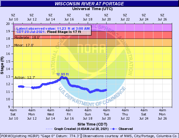 |
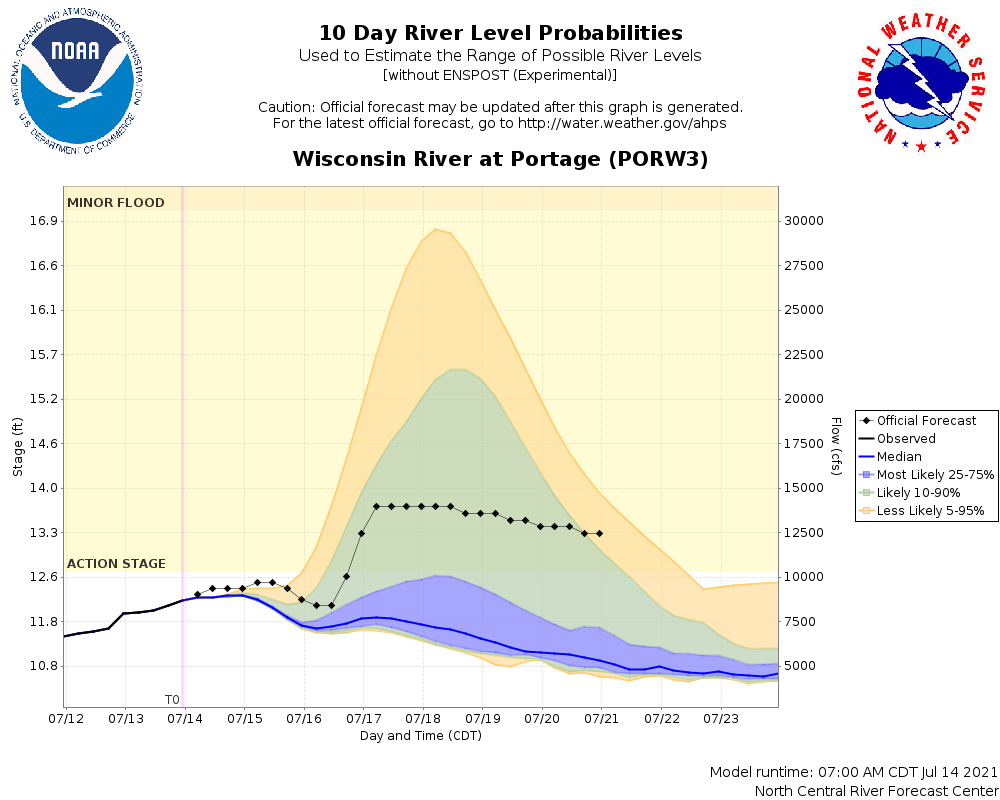 |
How To Interpret the Graphic:
The shaded areas show the predicted range of river levels over the next 10 days. There is also a chance the observed crest could exceed the highest crest shown. The forecast range can change over time and can be much larger for high rainfall events than for lower rainfall events.

Differences Between the Official River Forecasts and the New Probabilistic Guidance:
| Current, Official Forecast | New, Probabilistic Guidance |
|
Includes 24 or 48 hours of precipitation: 48 hours from Oct 1 to Mar 31 and 24 hours from Apr 1 to Sep 30 |
Includes 10 day of precipitation |
| Forecast created by a forecaster | Automated, No quality control by a forecaster - Model could be off |
| Updated at least twice a day, sometimes 3 or 4 times a day during flooding | Updated 2 times per day |
| Forecast may be too precise, and it does not show ranges of possible river crest | Range of river crests can help with planning but still may not show the highest crest |
Why Are There A Range of Forecast Crests?
The amount of rain and the time span it falls in affects the river level. More rain typically results in a higher river crest, while less rain typically results in a lower crest. The amount of melting snow also plays a role.
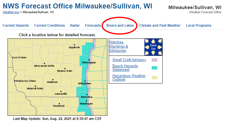
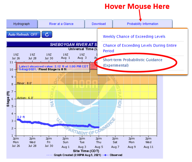
Where To Find It
From weather.gov/mkx/ go to the River and Lakes tab:
Select a river forecast location:
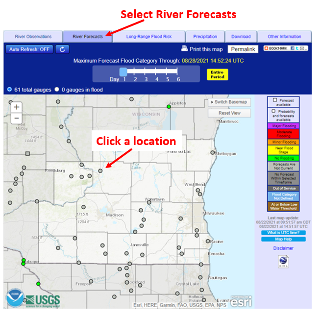
If graphics are available for that site, they will be posted under the Probability Information tab:
Additional Short Range Probabilistic River Guidance Information
The shaded area shows the range of possible river levels indicated by 59 different forecasts based on one model, the GFS. Other forecast models may predict more rain and this is one reason the actual river crest may be higher than what the forecast guidance shows. The modeled data will be updated twice daily, around 4:30 pm and 6:45 am. These times align with precipitation updates.
The new graphics are considered experimental and the NWS welcomes feedback.
Please send questions or comments to
Sarah Marquardt, Senior Service Hydrologist
sarah.marquardt@noaa.gov
Other River Outlooks
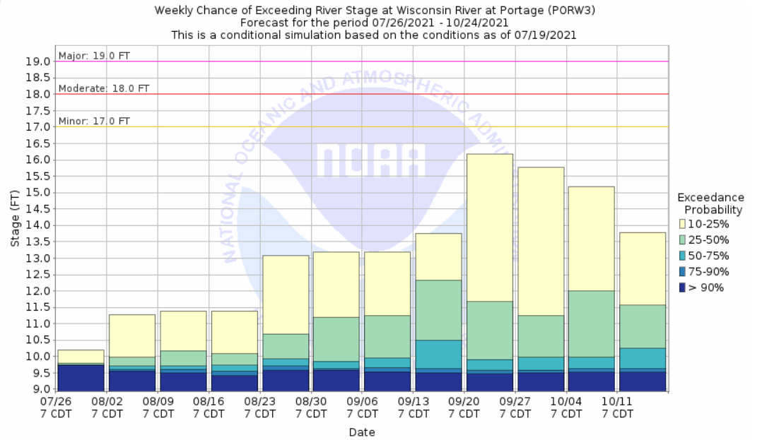
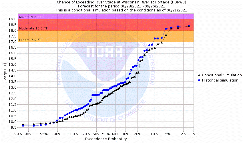
The short-term probabilistic guidance joins two other river outlooks on the NWS river forecast page: 1) probabilistic outlooks by week and 2) probabilistic outlooks for a 3 month time frame. The weekly outlook shows the probability of exceeding various flood stages during a specific week and the 3 month outlook shows the probability of exceeding various flood stages for a 3 month period compared to historical probabilities.
| Weekly Probabilistic Outlook | 3 Month Probabilistic Outlook |
 |
 |
 |
Media use of NWS Web News Stories is encouraged! Please acknowledge the NWS as the source of any news information accessed from this site. |
|

