Major flooding continues on the Baraboo River. The Baraboo River in Baraboo crested today (Saturday). The Baraboo River is gradually falling in Reedsburg and Rock Springs. Flooding will continue through the weekend. The Rock River and Fox River (in Green Lake County) are on the rise.
See the latest river stages and forecasts, along with the associated impacts:
https://water.weather.gov/ahps2/index.php?wfo=MKX
Here is more specific information about a few rivers that are in flood stage:
Baraboo River Near Baraboo:
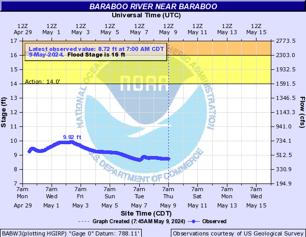
This graph automatically updates.
| Flood Stage | River level | Impacts |
| Major | 23.1 feet | Same as 22 feet |
| Moderate | 22 feet | (19-22 feet) Water affects trailer rental business and a road wayside park ~5 miles downstream near the Hwy 33 bridge. Water also affects an auto auction business near I-94. |
| Minor | 16 feet | Widespread flooding of agricultural land. |
Baraboo River at Rock Springs:
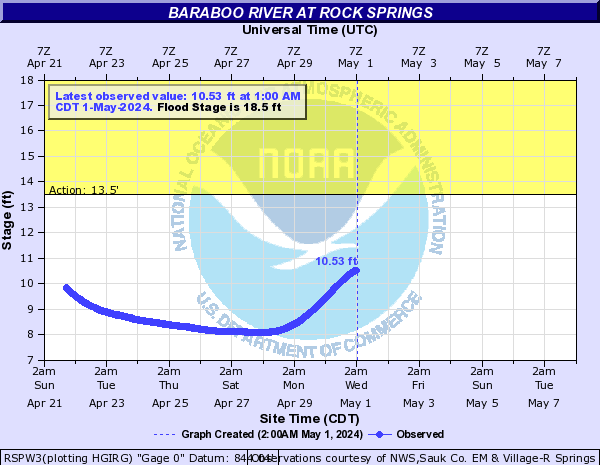
​This graph automatically updates.
| Flood Stage | River level | Impacts |
| Major | 23 feet | Floodwaters touch the base of the river gauge house in Rock Springs. Floodwaters cover much of Hwy DD, 154, and 136 in Rock Springs. Busser Park along Hwy 136 and the baseball diamond in Fireman's Park along Hwy DD are covered with water up to 4 feet deep. Floodwaters affect some businesses, including the Post Office along Hwy 154 in Rock Springs. |
| Moderate | 21 feet | Floodwaters are ~2 feet deep in the baseball diamond in Fireman's Park along Hwy DD. Water is over portions of Hwy DD, 154, and 136 in Rock Springs. |
| Minor | 18.5 feet | The river is well out of its banks and floodwaters affect a low spot on Hwy DD in Rock Springs. Farm fields are flooded in the Loganville area. |
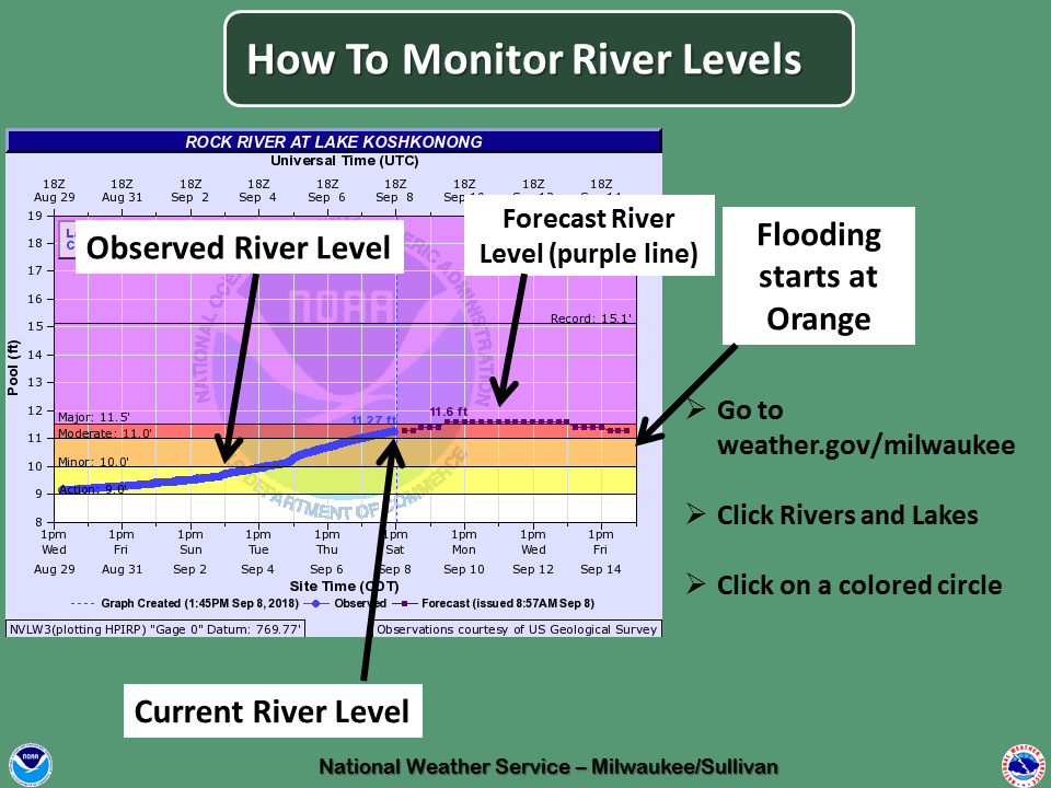
Rock River at Lake Koshkonong:
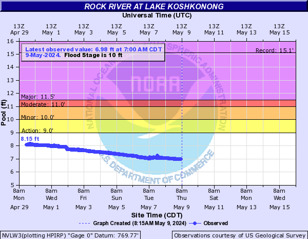
​This graph automatically updates.
| Flood Stage | River level | Impacts |
| Major | 11.5 feet | (11.26 feet) There is knee-deep water over Blackhawk Island Road. Lamp Road on west side of river also becomes flooded. Lake Koshkonong merges with Mud Lake to the east of Lake Koshkonong. |
| Moderate | 11 feet | Flooding of roads and docks in Town of Koshkonong and Town of Sumner including Ralph Road, Vets Lane, Blackhawk Island Road, Fox Hill Road, and Oxbow Bend Road. |
| Minor | 10 feet | Floodwaters affect homes and boat docks in the Blackhawk Island area on north side of Lake Koshkonong. Floodwaters spread over low spots on Blackhawk Island Road in the area where the Rock River enters the lake. |
Fox River at Berlin (in Green Lake County):
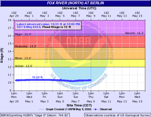
​This graph automatically updates.
| Flood Stage | River level | Impacts |
| Major | 16 feet | (16.2 feet) Many businesses and homes along Webster, Water, West Liberty, West Berlin, West Marquette, and Traverse Streets in Berlin are affected by floodwaters. |
| Moderate | 14.5 feet | There is moderate flooding in the Berlin area. Riverside and Webster Street Parks are flooded. A couple of homes along Webster St. are also affected. |
| Minor | 13 feet | Minor flooding in the Berlin area including Riverside Park and Webster Street Park. |
NWS Milwaukee/Sullivan, WI

