Milwaukee/Sullivan, WI
Weather Forecast Office
...Heavy Rainfall Possible Across Parts of Wisconsin Through Tonight...
A warm front will remain stalled across central Wisconsin through tonight. The front is combining with a low level jet stream and bringing persistent rounds of showers and thunderstorms into parts of southwest, west central and central Wisconsin. This is bringing periods of heavy rain and areas of flooding. A Flash Flood Watch is in effect for the southwest portion of the state. You can monitor area river stages by going to our Advanced Hydrologic Prediction Service page.
We are watching for an area of showers and storms to develop across southern Wisconsin this evening (most likely southwest Wisconsin). Keep up with the latest forecasts. Below is a 24 hour forecast rainfall total from 7 PM Thursday through 7 PM Friday.

Regional Radar Views:
 |
 |
Local Radar:

Parts of Wisconsin received 4 to 8 inches of rain from late Tuesday night through this morning (48 hour precipitation total below, as of 7 am Thursday). The heaviest hit areas were in southwest Wisconsin between La Crosse and Portage. There was a report of just over 6 inches in southwest Marquette County near Briggsville. Madison also experienced a period of heavy rain Wednesday afternoon around 4:30 pm. The Dane County Regional Airport reported a total of 2.42 inches between 7 pm Tuesday and 7 pm Wednesday.


Here is a clickable map with the additional forecast rainfall over south central and southeast Wisconsin:
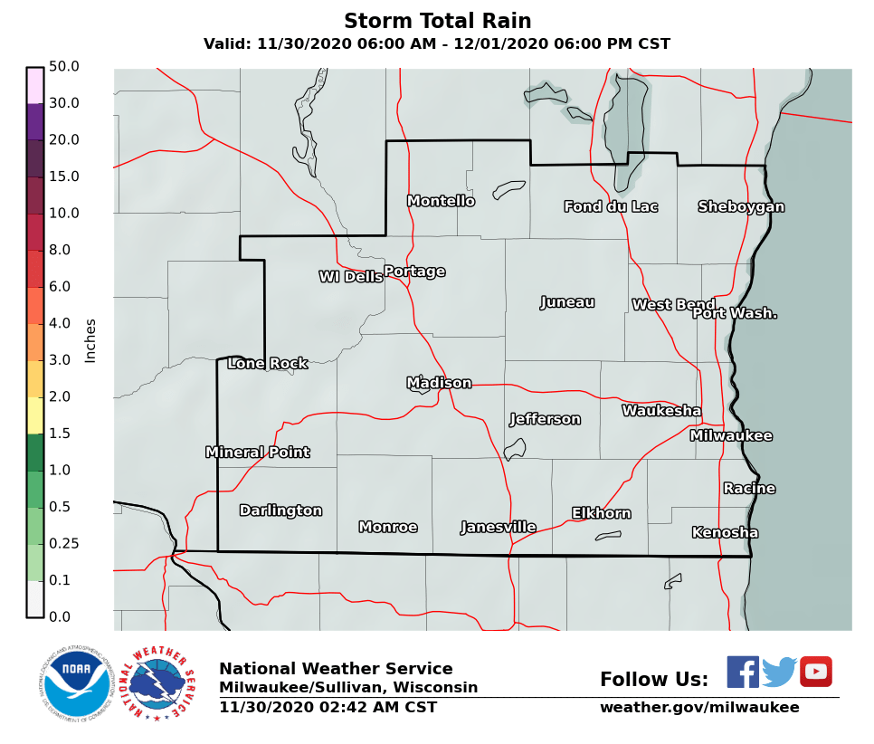
Here is a clickable map with the additional forecast rainfall over all of Wisconsin:

Main hazards:
Current Weather Story:
Short Term - Watches And Mesoscale Discussions:
|
Current Watches |
Latest Mesoscale Discussions |
Current Headlines:

Day 1 (Today and Tonight) Convective Outlook: (Key to interpreting categories/colors)

Day 2 (Thursday and Thursday Night) Convective Outlook:

Day 3 (Friday and Friday Night) Convective Outlook:

Links of interest:
Local Storm Report Graphic
Local Storm Report Text
SPC Local Storm Reports
Submit a Storm Report
Hazardous Weather Outlook
Forecast Discussion
Severe Thunderstorm Warnings
Tornado Warnings
Flash Flood Warnings
Severe Weather Statements
SPC Meso-Analysis Page
Our Severe Weather Page
Wood/Schultz/Cronce/Miller
NWS Milwaukee/Sullivan, WI
Hazards
National Briefing
Hazardous Weather Outlook
Skywarn
View Local Storm Reports
Submit A Storm Report
Winter Weather
Summer Weather
Beach Hazards
Local Forecasts
Marine
Aviation
Fire
Local Text Products
Local Precip Forecast
Hourly Forecast Graphics
Forecast Discussion
Climate
Daily Climate Graphics
Local Climate Products
Normals/Records MKE/MSN
CoCoRaHS
Historic Events For Srn WI
US Dept of Commerce
National Oceanic and Atmospheric Administration
National Weather Service
Milwaukee/Sullivan, WI
N3533 Hardscrabble Road
Dousman, WI 53118
262-965-2074
Comments? Questions? Please Contact Us.
Thank you for visiting a National Oceanic and Atmospheric Administration (NOAA) website. The link you have selected will take you to a non-U.S. Government website for additional information.
NOAA is not responsible for the content of any linked website not operated by NOAA. This link is provided solely for your information and convenience, and does not imply any endorsement by NOAA or the U.S. Department of Commerce of the linked website or any information, products, or services contained therein.
You will be redirected to:


