We've had a long stretch of warm, late summer weather across southern Wisconsin. Our days with highs in the 80s will come to an end as a strong cold front drops in later tonight. The front is expected to trigger a round of strong to possibly severe thunderstorms as it moves through Wisconsin.
The front will then stall just south of Wisconsin on Friday, allowing a low pressure system to track northeast along it, bringing another round of showers and thunderstorms Friday afternoon through Friday night. These two rounds of rainfall could produce a total of 1.2 to 1.7 inches of rainfall for southern Wisconsin. Locally higher amounts are possible.
Below are some images depicting how the weather will unfold. The first is round one, this afternoon into this evening:

We'll have to remain alert for the potential of strong to severe thunderstorms with the cold front this afternoon and evening. Here is the Storm Prediction Center outlook for the period of concern. The slight risk area is generally to the west and north of a line stretching from Green Bay to Dubuque. The rest of southern Wisconsin is in a marginal risk for severe thunderstorms.

Round two of the showers and thunderstorms will come in Friday afternoon through Friday night. The image below generally depicts how that will look.

The low pressure system moving along the front will bring a swath of moderate to heavy rainfall along and north of the cold front. Rainfall across the southeast could approach 1 inch, while lower amounts will be found north and west of Madison. It's a bit early for falling leaves, but if you have any gutters that may be blocked with debris, now would be a time to fix that (the usual safety precautions should be taken).
Here is the Storm Prediction Center outlook for severe weather on Friday.

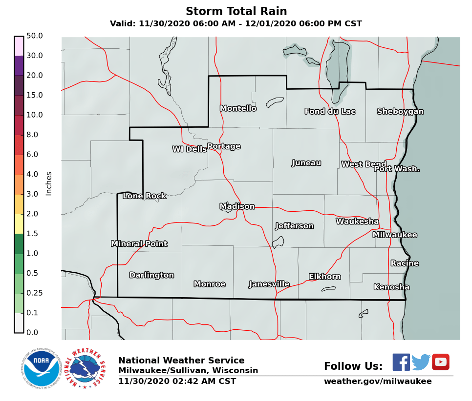
After these two rounds of rain, this is how the rainfall is forecast to tally up:

Regional Radars
 |
 |
Local Radar:

Links of interest:
Local Storm Report Graphic
Local Storm Report Text
SPC Local Storm Reports
Submit a Storm Report
Hazardous Weather Outlook
Forecast Discussion
Severe Thunderstorm Warnings
Tornado Warnings
Flash Flood Warnings
Severe Weather Statements
SPC Meso-Analysis Page
Our Severe Weather Page

