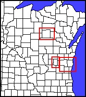
There were 12 confirmed tornadoes across Wisconsin on July 18, 1996. Click red-boxed areas on the graphic to the left to see detailed maps of where they occured.
Statewide Impact:
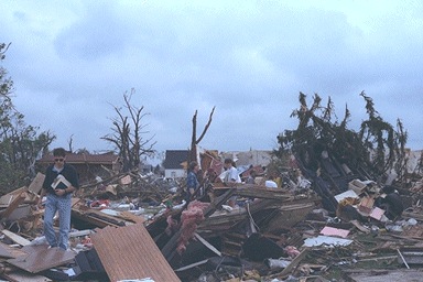
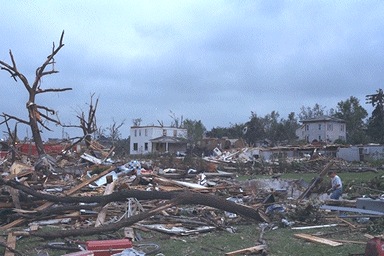
Property Damage $40.7 Million Crop Damage $1.7 Million
A personal account of the Oakfield Tornado as told by Kelly Wojahn:
"This is my personal account (to the very best of my recollection) of what happened the night of July 18th, 1996 - the night of the Oakfield Tornado.
That evening, my co-ed softball team was scheduled to play a game. I remember it was beautiful out,and it was very warm. About 85+ degrees that day. The sky was blue, but there was a tornado watch put out at about 4:30pm. The game was set to start at 6pm. We were at a softball diamond in Ladoga on Hwy. TC (otherwise known as 103).
Since I have always been intruiged by storms... I kept my eye to the sky. At that time, there wasn't a single cloud. But by the time I was up to bat for the first time, I remember that I saw a tiny patch of clouds Southwest of us that had just appeared out of nowhere.
These clouds were slowly moving Northeast and very slowly growing larger. By the time they were above our heads, they had grown into a long, but skinny, line of clouds that stretched from West to East. They moved to the North of us and then we all heard a loud rumbling noise. Most of us just dismissed this as a plane, and didn't think much of it. But then we realized the noise was constant and not letting up. We decided it must be coming from the thin line of clouds, which seemed very odd.
The rumbling continued for what seemed to be forever, and then we noticed the line of clouds expanding to the North and South and also darkening.
Not much later, the noticeably larger mass of clouds started moving back toward us- towards the Southeast. We hurried the game along, as we figured it would start raining any time.
We were right, a few minutes later it began to downpour. But only for a minute or so. The clouds then stalled overhead and became very eerie. It wasn't raining, so we continued to play as much as we could. After 2 or 3 batters, it began to rain hard again and it also began to hail. This wasn't a good sign, but it let up again a couple minutes later. At this point, we were determined to finish the game.
We all got back on the field... and it didn't rain again. A couple of us did notice that the clouds were beginning to swirl and expand even more. This made us feel a bit uneasy, but no one else seemed too bothered by it.
Although it was still rumbling constantly, there hadn't been any lightning- just rain and hail. We continued to play.
Not much later, the clouds were swirling and rotating like crazy, but the clouds started moving quickly to the Southeast- away from us. There was a big house and tree on the East side of the field that blocked most of the sight in that direction if you were batting. Only the outfielders could see past the house.
Then, I remember that we switched one last time... we came in to bat, and the other team went out in the field. All of a sudden,the fielder in left field started jumping up and down and screaming. None of us could hear him over the rumbling.
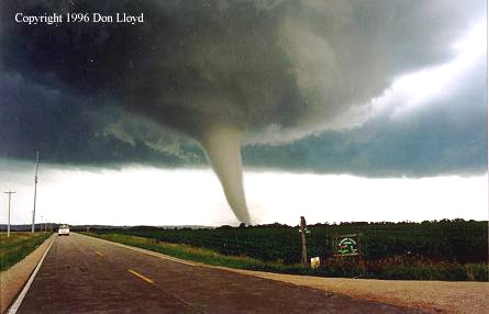
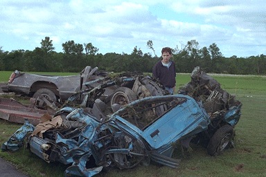
We ran out there just as the funnel cloud he was screaming about turned into a full-blown tornado... bigger than I ever imagined a tornado being in real life. It was about 1/2 mile to 3/4 miles away from us.
We stood there in awe, and then realized we needed to get out of there. By that time, my friend's parents were already there in their truck to pick us up (they lived about a 1/2 mile down the road). We took the truck and rode behind the tornado so we could get to the houses where it first touched down.
There were 3 houses in this area that were hit. We all split up and went to see who needed help. People started coming out of their basements in complete shock. Luckily, no one was hurt beyond a cut or a bruise. We helped them salvage what we could... pictures, breakables, etc. and called to get them more help. One of the men we helped found his boat more than 2 miles away a couple days later.
When we left this area, we used the CB in the truck to call into Oakfield. We had a chainsaw and 2 of us knew CPR and first aid. They had blockades everywhere, so we couldn't get into town- even though we told them were were there to help. It was very chaotic, so we understood.
I know that we helped as much as we could, but I wished we could have done more. I have since learned a lot about what I experienced that day. The Oakfield Tornado sparked my interest in what I can do to help my community, so I have taken storm spotting classes to learn about what I saw. There was a good 10 minutes or so from when the clouds started rotating to when the funnel cloud developed. If I had known more about the structures of thunderstorms and what to watch for, I think I could have recognized what was going on in time to warn someone."
 This image, showing the nice rounded, rotating updraft was taken in Ozaukee county, from the north side of Port Washington, looking north. This tornado spun up near Fredonia and moved southeast out over Lake Michigan. This supercell wasn't the same one that spun up the Oakfield tornado, but rather, one of several supercells that moved southeast that evening across southeast Wisconsin. This image, showing the nice rounded, rotating updraft was taken in Ozaukee county, from the north side of Port Washington, looking north. This tornado spun up near Fredonia and moved southeast out over Lake Michigan. This supercell wasn't the same one that spun up the Oakfield tornado, but rather, one of several supercells that moved southeast that evening across southeast Wisconsin. |
A message from Rusty Kapela, former Warning Coordination Meteorologist at the NWS Office at Milwaukee/Sullivan...
You have just read a personal account of the development of the Oakfield tornado. If you find yourself in a similar situation, and notice a tornado spin-up, call your local law enforcement official, and ask them to relay your report to the National Weather Service (NWS). Of course, your personal safety comes first - make sure you are safe, and then attempt to relay a severe weather report. The NWS needs to know what you observed, where it was located, and the time it occurred.
I recommend that only trained severe weather spotters call their local law enforcement official with reports of initial tornado development, or with reports of cloud features (rotating wall cloud) that usually precede tornado development. Untrained spotters are likely to mis-identify precursor cloud features and initial tornado development, and call in false reports. This happens many times each summer. Once you have been trained by me, I will give you our 800-number which is reserved for severe weather spotters. You would call your local law enforcement official, but also call the Milwaukee-Sullivan NWS office with your report.
The spotting of tornado development isn't easy. You need to understand thunderstorm structure and where tornadoes usually develop. You can easily get yourself into trouble, or relay a false tornado, funnel cloud, or rotating wall cloud report, if you don't understand thunderstorm structure.
You can find information on how to become a spotter at this web site address:
|


