Milwaukee/Sullivan, WI
Weather Forecast Office
...Strong To Severe Thunderstorms Possible Tonight...
Strong to severe thunderstorms are expected after 2 AM tonight and into early Monday morning.
Main threat:
Thunderstorms are expected to form late this afternoon and evening over the eastern Dakotas and Minnesota, then slide southeast into southern Wisconsin during the overnight hours. Scattered storms may develop sometime after 2 AM. Then a line of thunderstorms is expected to move southeast across southern Wisconsin from about 4 AM to 8 AM Monday morning.
Additional severe thunderstorms are possible during the afternoon and evening on Monday.
If you get severe weather, send us your report! Key elements: Time - Location - Type of severe weather/damage, etc
Short term - Watches and Mesoscale Discussion (not much action here until later today):
|
Current Watches |
Latest Mesoscale Discussions |
Current Headlines:

Day 1 Convective Outlook: (Key to interpreting categories/colors)

Day 2 Convective Outlook:

Regional Radar Views:
 |
 |
Local Radar:

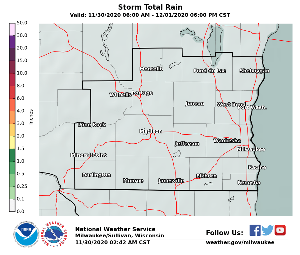
Expected Rainfall Amounts:
 |
Links of interest:
Local Storm Report Graphic
Local Storm Report Text
SPC Local Storm Reports
Submit a Storm Report
Hazardous Weather Outlook
Forecast Discussion
Severe Thunderstorm Warnings
Tornado Warnings
Flash Flood Warnings
Severe Weather Statements
SPC Meso-Analysis Page
Our Severe Weather Page
Davis
Hazards
National Briefing
Hazardous Weather Outlook
Skywarn
View Local Storm Reports
Submit A Storm Report
Winter Weather
Summer Weather
Beach Hazards
Local Forecasts
Marine
Aviation
Fire
Local Text Products
Local Precip Forecast
Hourly Forecast Graphics
Forecast Discussion
Climate
Historic Events For Srn WI
Daily Climate Graphics
Local Climate Products
Normals/Records MKE/MSN
CoCoRaHS
US Dept of Commerce
National Oceanic and Atmospheric Administration
National Weather Service
Milwaukee/Sullivan, WI
N3533 Hardscrabble Road
Dousman, WI 53118
262-965-2074
Comments? Questions? Please Contact Us.


