Southern and Central Wisconsin's Hurricane-force Downburst Wind Event on May 30-31, 1998(By WCMs Rusty Kapela (retired), Jeff Last, and Todd Shea)
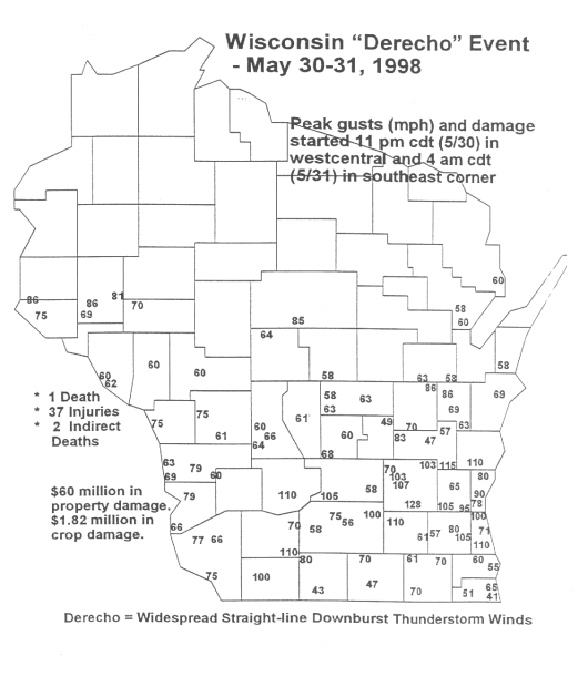
Southern and central Wisconsin residents and travelers experienced a devastating, widespread thunderstorm wind damage event during the late evening hours on Saturday, May 30th into the early morning hours of Sunday, May 31, 1998. The damage, totaling about $60 million to property and $1.82 million to crops, was the most widespread and intense (downburst related) during the past 20 years. Three people were killed during or shortly after the event: 1 directly and 2 indirectly. At least 37 people. Hundreds of structures such as homes, businesses, and farm buildings were damaged; thousands of trees were toppled or split, and hundreds of power lines were pushed over. Meteorologically, a line of severe thunderstorms, referred to as a squall line, raced east at about 50 mph across the southern two-thirds of the Badger state. Embedded in the squall line were several intense macrobursts and microbursts that resulted in concentrated swaths of structural or tree damage. Measured wind gusts exceeded minimal hurricane-force speeds of 74 mph in many locations, and in several spots exceeded 100 mph. The maximum measured wind gust was 128 mph northeast of Watertown in southern Dodge county. In addition, seven tornadoes touched down, scattered from west central to east central Wisconsin, and there were several large hail occurrences.
In the early 1980's the scientific community "christened" widespread thunderstorm wind events as "derechos", and the Wisconsin May 30-31 event ranks right up there with the worst of them. Residents described the powerful winds as sounding like "screaming freight trains," and couldn't believe the amount of damage in their wake. Overall, the damage in the worst hit areas resembled what would be generated by a lower-end F2 tornado (F2 has wind speeds of 113 to 157 mph). A series of individual downbursts with gusts to around 100 mph or more favored a corridor from southern Sauk county east/southeast to the Milwaukee area. Another favored area was across northern Dodge county through southern Fond du Lac county into southern Sheboygan and parts of Ozaukee county. The storm cluster that was responsible for southern Wisconsin's derecho initially spawned the killer tornado that leveled the South Dakota village of Spencer during the early evening hours of May 30th. The storms then moved east through southern Minnesota and began to generate straight-line downburst events. Maximum wind gusts eventually reached hurricane-force levels in the Twin Cities area late on the 30th. As the storms moved into Wisconsin they became more organized, increased in strength. This derecho also raked Lower Michigan during the daylight hours on the 31st, and eventually pushed east through New York state, where more killer tornadoes were reported. In the warning department, the National Weather Service Offices in Milwaukee/Sullivan, Green Bay, La Crosse, and Minneapolis/Chanhassen issued numerous severe thunderstorm warnings for the strong straight-line wind gusts. These warnings were issued anywhere from 25 to 45 minutes prior to the onset of damaging winds in the counties. |