Memphis, TN
Weather Forecast Office
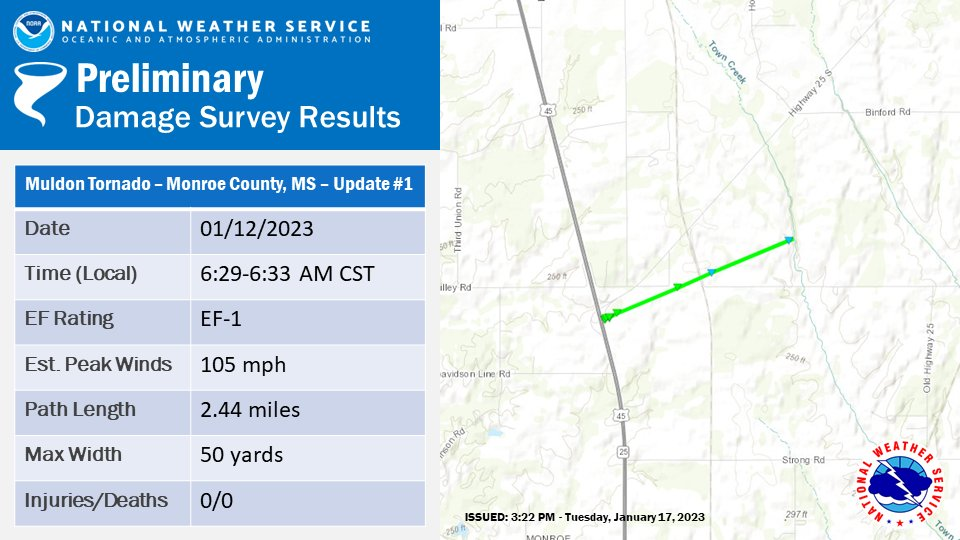
Public Information Statement
National Weather Service Memphis TN
341 PM CST Tue Jan 17 2023

...NWS Damage Survey for 01/12/23 Tornado Event...

Update #1 to the previous damage survey for the Muldon Tornado in Monroe
County to extend the track length and width.

.Muldon Tornado...

Rating:                 EF1
Estimated Peak Wind:    105 mph
Path Length /statute/:  2.44 miles
Path Width /maximum/:   50 yards
Fatalities:             0
Injuries:               0

Start Date:             01/12/2023
Start Time:             06:29 AM CST
Start Location:         5 S Prairie / Monroe County / MS
Start Lat/Lon:          33.7182 / -88.6716

End Date:               01/12/2023
End Time:               06:33 AM CST
End Location:           5 SSE Prairie / Monroe County / MS
End Lat/Lon:            33.7318 / -88.6325

Survey Summary:
A brief tornado initially touched down to the southeast of the
Intersection of highways 45A and 25. A house had its porch ripped
off, considerable roofing removed, and garage door and roof
completely removed. A workshop in the back was completely
destroyed. Two power poles were snapped behind the house. No
injuries were reported as the house was unoccupied at the time.
The damage continued across Sykes Rd to Town Creek with multiple
large trees uprooted. The tornado finally lifted up as it reached
Town Creek.

&&

EF Scale: The Enhanced Fujita Scale classifies tornadoes into the
following categories:

EF0...Weak......65 to 85 mph
EF1...Weak......86 to 110 mph
EF2...Strong....111 to 135 mph
EF3...Strong....136 to 165 mph
EF4...Violent...166 to 200 mph
EF5...Violent...>200 mph

NOTE:
The information in this statement is preliminary and subject to
change pending final review of the event and publication in
NWS Storm Data.


CURRENT HAZARDS
Briefing Page
Outlooks
Submit a Storm Report
Submit a Storm Photo
View Storm Report
Spot Forecast Request
Hazard Outlook
FORECASTS
Local
Graphical
Probabilistic
Precipitation
Aviation
Fire
Severe Weather
Winter Weather
Tropical Weather
Air Quality
US Dept of Commerce
National Oceanic and Atmospheric Administration
National Weather Service
Memphis, TN
7777 Walnut Grove Road, OM1
Memphis, TN 38120
(901) 544-0399
Comments? Questions? Please Contact Us.

