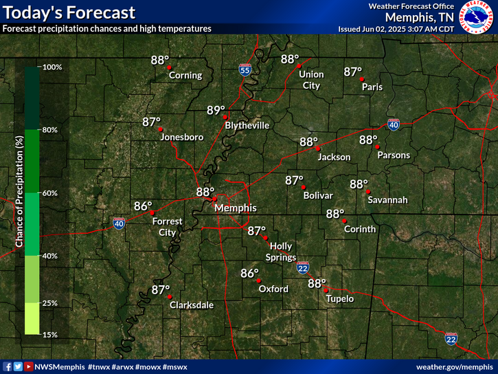
National Weather Service United States Department of Commerce
News Headlines
Click a location below for detailed forecast.

Last Map Update: Tue, Jul 15, 2025 at 3:38:19 pm CDT


Heat indices will be on an upward trend this week. Be sure to exercise caution if you must be outside for prolonged periods.
Isolated showers and thunderstorms, mainly north of I-40 today. Humid, with Highs 90 to 95.
Mostly clear tonight. An isolated evening thunderstorm or two near the Missouri, Kentucky and Tennessee borders. Mostly clear overnight with lows in the lower to mid 70s.

graphical hazard
Graphical Hazards
probabilistic
Probabilistic
current weather
Current Weather
be prepard
Being Prepared
estar preparado
Estar Preparado
safety
Weather Safety

Text Product Selector (Selected product opens in current window)

Hourly Weather Roundup ( )
Location Sky/Weather Temp Dewpt RH Wind Baro Remarks
Memphis, TN
N/A
N/A
N/A
N/A
N/A
N/A
N/A
Jackson, TN
N/A
N/A
N/A
N/A
N/A
N/A
N/A
Jonesboro, AR
N/A
N/A
N/A
N/A
N/A
N/A
N/A
Tupelo, MS
N/A
N/A
N/A
N/A
N/A
N/A
N/A
West Memphis, AR
N/A
N/A
N/A
N/A
N/A
N/A
N/A
Blytheville, AR
N/A
N/A
N/A
N/A
N/A
N/A
N/A
Dyersburg, TN
N/A
N/A
N/A
N/A
N/A
N/A
N/A
Oxford, MS
N/A
N/A
N/A
N/A
N/A
N/A
N/A
Note: "N/A" or "MISG" will be displayed if values are not available. In the LOCATION column, click on links for a list of recent observations at sites of interest. In the WIND column, VRB is "variable" and G is "gust". Wind speeds are in MPH. In the BARO (pressure) column, values are in inches. In the REMARKS column, HX is "heat index", WCI is "wind chill index", and VSB is "visibility" (if shown).