
Strong to severe thunderstorms will continue tonight across portions of the Ohio Valley into the Mid-Atlantic. Heavy rains may bring an isolated flash flooding threat over the central Appalachians, particularly in West Virginia. Moderate to heavy snow will continue over portions of northern Minnesota and the Upper Peninsula of Michigan through Tuesday morning. Read More >
In early September, ground across Virginia, Maryland, and the District of Columbia was saturated, following a very wet August even prior to the drenching from Hurricane Irene. Tropical Storm Lee developed in the northern Gulf of America on September 1 and made landfall in Louisiana on September 4. Lee moved northeastward into the Tennessee Valley as a Tropical Depression, eventually becoming extratropical. Southerly flow on the east side of Lee allowed rich tropical moisture to surge up the Eastern Seaboard and into the Mid-Atlantic. High pressure centered over eastern Canada blocked this moisture from moving further north and caused it to pool across our region. The high pressure also halted Lee’s northward progress, forcing it to drift northward over the Central Appalachians for several days. Bands of heavy rain developed and moved north across the area beginning on September 6th and continued through September 9th. During this period, rainfall totals were excessive, exceeding 12 inches in many locations. The most intense rain bands formed on Wednesday, September 7th and Thursday, September 8th, when the worst flash flooding occurred.
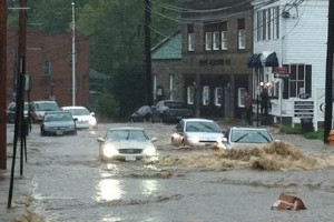
On Wednesday morning, September 7th, a torrential rainband set up in a north/south orientation across Maryland from Charles County into Baltimore County. Rainfall rates of 2 to 3 inches per hour occurred for several hours within this band, causing numerous high water rescues, road closures, and flooded homes. Of note was a rain gauge in Bowie, MD, that observed 4.57 inches of rain in 3 hours, which is an amount that only has a 0.5 percent chance of occurring in a given year. Central Charles County (above) and Ellicott City (left) in Howard County were particularly hard hit.
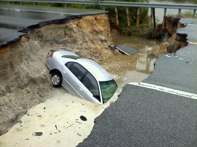
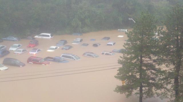
On Thursday, September 8th, the heaviest rainband set up slightly west of the previous day. This band brought torrential downpours through much of the daytime hours along a swath from King George County, VA to Montgomery County, VA, including the western suburbs of Washington DC. Extremely anomalous 3-hour rainfall amounts were recorded at several automated rain gauges during the event. One near Franconia observed 5.47 inches, a 3 hour amount that has approximately a 0.2 percent chance of occurring in any given year. A similarly rare six hour rainfall amount of 6.57 was observed at Reston (see right). Also, at Fort Belvoir, an automated weather station tallied 7.03 inches in only 3 hours. Rainfall of this magnitude and duration has a 1 in 1000 chance of occurring each year. This amount of rain caused nearly catastrophic flash flooding in portions of northern Virginia. Tragically, at least 2 people lost their lives in floodwaters in Fairfax County. Hundreds of citizens of Fairfax and Prince William County were evacuated. Numerous major thorough-fares were flooded and closed, including portions of the Capital Beltway, Interstate 66, and George Washington Parkway. The Virginia Railway Express’s Manassas Line and numerous school districts remained closed into Friday as floodwaters slowly subsided.
Over the course of the event, 34 Flash Flood Warnings were issued by the Baltimore-Washington Forecast Office. There were over 100 reports of flash floods received by our office. This rainfall and the overall wet period of August and September 2011 will go down in the record books in a number of ways. At Baltimore-Washington International Airport (BWI), several daily rainfall records were broken. September 2011 ranked the wettest September on record, with 13.32” of rain being tallied. The two-month period set the record wettest 2 months ever recorded at BWI, with 23.70”. The remnants of Tropical Storm Lee proved to be a reminder for residents of the Mid-Atlantic of the dangers of flash flooding. Always remember when high water is observed, turn around, don’t drown.
|
Allens Fresh (Charles County, MD) |
Main Street in Ellicott City |
|
Reston Park and Ride (Fairfax County, VA) |
PUBLIC INFORMATION STATEMENT
NATIONAL WEATHER SERVICE BALTIMORE MD/WASHINGTON DC
932 AM EDT WED SEP 14 2011

...RECENT HEAVY RAINFALL WAS A RARE EVENT...

THE MID-ATLANTIC REGION...ESPECIALLY FROM WASHINGTON AND BALTIMORE
EASTWARD...HAVE RECENTLY BEEN AFFECTED BY BOTH HURRICANE IRENE AND
A WET PERIOD CAUSED LARGELY BY THE REMNANTS OF TROPICAL STORM LEE.

SOME OF THE HIGHEST RAINFALL TOTALS OVER THE LAST 30 DAYS INCLUDE...
TRUMAN DRIVE IN LARGO        24.13
CABIN BRANCH - FORESTVILLE   23.98
LEELAND ROAD IFLOWS          23.62
HERRING ROUTE 40 BALTIMORE   23.11
BRISTOL                      23.04
BOWIE                        22.90
PRINCE GEORGES JUSTICE CTR   22.87
LAKE ARBOR - LARGO           22.52
DISTRICT HEIGHTS             21.49
KINGSTOWNE - FAIRFAX         20.34
FORT MCHENRY                 19.83
FORT BELVOIR                 18.61
BWI AIRPORT                  17.43

ADDITIONALLY...THE REMNANTS OF LEE BROUGHT TWO INTENSE BANDS OF
RAINFALL TO THE REGION...ONE STRETCHING FROM CHARLES COUNTY
NORTHWARD INTO BALTIMORE COUNTY...AND ANOTHER FROM KING GEORGE
COUNTY NORTHWARD INTO MONTGOMERY COUNTY. THESE RAINBANDS LED TO
RAINFALL THAT IS EXTREMELY UNUSUAL.

ON WEDNESDAY...SEPTEMBER 7TH...THE IFLOWS GAUGE IN BOWIE RECORDED
4.57 INCHES IN THREE HOURS...WHICH HAS APPROXIMATELY A 0.5 PERCENT
CHANCE OF OCCURRING IN ANY GIVEN YEAR /SOMETIMES CALLED A 200-YEAR
RAINFALL/.

FOR ELLICOTT CITY...WHERE SEVERE FLASH FLOODING OCCURRED...THE
RAINS WERE ACTUALLY LESS RARE...ROUGHLY A 1 TO 2 PERCENT CHANCE OF
OCCURRING IN ANY GIVEN YEAR.

THE HEAVY RAINS ON THURSDAY...SEPTEMBER 8TH...WERE EVEN MORE RARE.
THE KINGSTOWNE IFLOWS GAUGE NEAR FRANCONIA IN FAIRFAX COUNTY
RECORDED 5.47 INCHES IN JUST THREE HOURS...WHICH HAS APPROXIMATELY
A 0.2 PERCENT CHANCE OF OCCURRING IN ANY GIVEN YEAR /SOMETIMES
CALLED A 500-YEAR RAINFALL/. THE SAME IS TRUE FOR RAINS IN
RESTON...WHERE 6.57 INCHES WAS RECORDED IN SIX HOURS.

AT FORT BELVOIR...THE AUTOMATED WEATHER STATION THERE RECORDED AN
INCREDIBLE 7.03 INCHES IN JUST THREE HOURS. THIS HAS LESS THAN A
0.1 PERCENT CHANCE OF OCCURRING IN ANY GIVEN YEAR /SOMETIMES
CALLED A 1000-YEAR RAINFALL/.

THESE VALUES ARE PRELIMINARY AND BASED ON PRECIPITATION FREQUENCY
CALCULATIONS FROM THE NEAREST AVAILABLE STATION. THE VALUES ARE
SUBJECT TO CORRECTION.


 Coastal Flood
 FAQ
FAQ