
Lake effect snow will continue downwind of the Lower Great Lakes through Wednesday, with accumulations of 4 to 8 inches possible for portions of Upstate New York and the Adirondacks. Gusty winds and dry conditions will result in critical fire weather conditions in the Southwest and Southern Plains Wednesday through Friday. Red Flag Warnings have been issued. Read More >
Baltimore/Washington
Weather Forecast Office
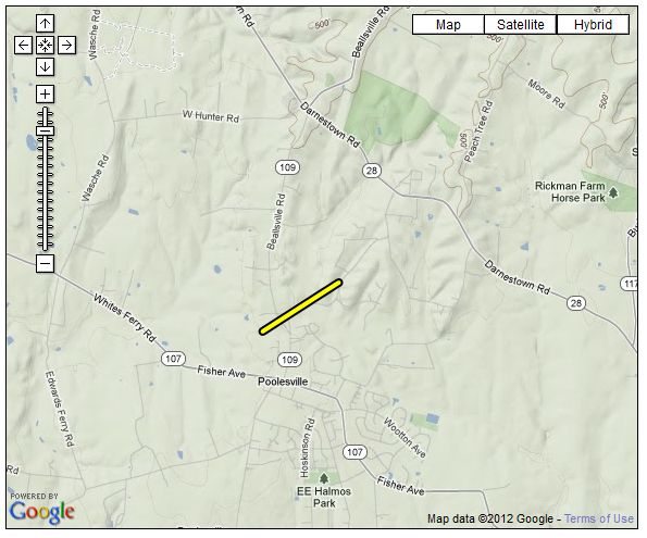
...EF-0 TORNADO CONFIRMED NEAR POOLESVILLE MARYLAND...

LOCATION...NORTH OF POOLESVILLE IN MONTGOMERY COUNTY MD
DATE...APRIL 28 2011
ESTIMATED TIME...6:45 AM TO 6:47 AM EDT
MAXIMUM EF-SCALE RATING...EF-0
MAXIMUM WIND SPEED...65 MPH
MAXIMUM PATH WIDTH...50 YARDS
LENGTH...0.8 MILES
BEGINNING LAT/LON...39.152N / 77.420W
ENDING LAT/LON...39.158N / 77.408W
* FATALITIES...NONE
* INJURIES...NONE

* THE INFORMATION IN THIS STATEMENT IS PRELIMINARY AND SUBJECT TO
CHANGE PENDING FINAL REVIEW OF THE EVENT/S/ AND PUBLICATION IN NWS
STORM DATA.

...SUMMARY...
A SHORT DAMAGE PATH NORTH OF POOLESVILLE MARYLAND WAS DETERMINED BY
NATIONAL WEATHER SERVICE GROUND SURVEY. SPOTTY TREE DAMAGE WAS
OBSERVED ALONG THE TRACK ON BEALLSVILLE ROAD...ELGIN ROAD AND
JERUSALEM ROAD. A TRAMPOLINE WAS LOFTED AND DEPOSITED ATOP A POWER
POLE...WITH ADJACENT DAMAGE TO A FENCE AND SMALL TREE.
US Dept of Commerce
National Oceanic and Atmospheric Administration
National Weather Service
Baltimore/Washington
Weather Forecast Office Baltimore/Washington
43858 Weather Service Rd.
Sterling, VA 20166
(571) 888-3500
Comments? Questions? Please Contact Us.


 Coastal Flood
 FAQ
FAQ