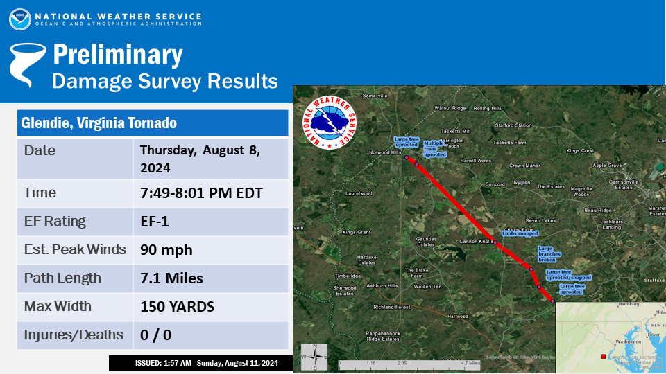
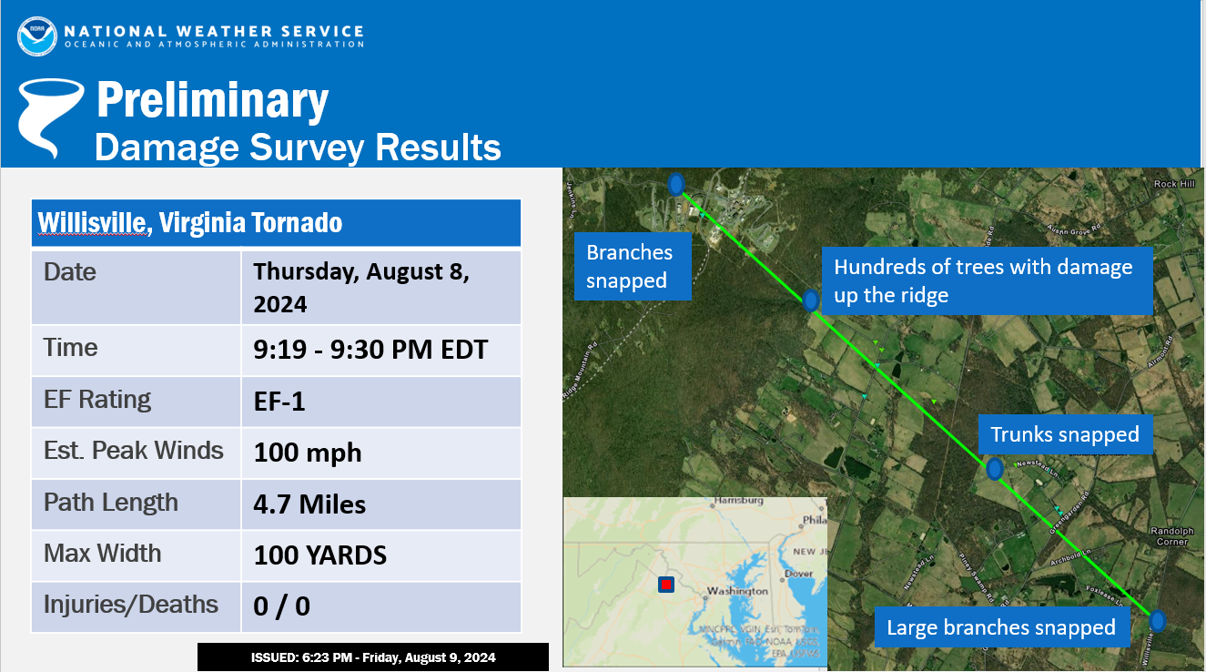
Public Information Statement
National Weather Service Baltimore MD/Washington DC
1101 AM EDT Mon Aug 12 2024

...NWS Damage Surveys for 8/8/24 Tornado Event Update 2...

.Update 2...
Additional information was received that extended the track of the
Hedgesville WV tornado another two tenths of a mile to the
northwest.

.Overview...The remnants of Hurricane Debby passed over the Mid
Atlantic, spawning tornadoes in northern and eastern Virginia as
well as eastern West Virginia panhandle.

.Glendie VA Tornado...

Rating:                 EF-1
Estimated Peak Wind:    90 mph
Path Length /statute/:  7.1 miles
Path Width /maximum/:150 yards
Fatalities:0
Injuries:0

Start Date:             August 08 2024
Start Time:             7:49 PM EDT
Start Location:         1 NW Glendie / Stafford County / VA
Start Lat/Lon:          38.4097 / -77.5131

End Date:               August 08 2024
End Time:               8:01 PM EDT
End Location:           1 W Heflin / Stafford County / VA
End Lat/Lon:            38.4883 / -77.5925

Survey Summary: National Weather Service Baltimore/Washington
Weather Forecast Office staff conducted a ground survey of storm
damage in western Stafford County that occurred on Thursday
evening, August 8, 2024. NWS Doppler Radar in Sterling, Virginia
showed a rotating severe thunderstorm that produced a tornado
just before 8pm August 8, 2024.

The tornado touched down one mile northwest of Glendie, Virginia
in the vicinity of Kellogg Mill Road and Mt. Olive Road around
7:49 PM EDT. Multiple large trees were snapped at the trunk and
uprooted, leading to the closure of Mt. Olive Road for a period of
time Thursday evening. The tornado continued northwest toward the
Saratoga Woods And Manor Woods Estates subdivision. Multiple
medium to large trees were uprooted, branches sheared off, or
otherwise damaged along Arden Lane and Mt. Olive Road.
The tornado traveled toward the Poplar Manor subdivision
along Stony Hill Road. One tree was snapped and uprooted along
Stately Avenue with another smaller tree and branches sheared off
toward the back end of Poplar Avenue. This damage coincides with
tightening rotation that was indicated on the KLWX radar around
7:55 PM EDT.

By 7:57 PM, radar picked up a tornado debris signature as the
storm moved northwest along Potomac Run toward Hartwood Road.
Several medium to large trees were uprooted, branches sheared off,
or otherwise damaged between the 1600 block of Hartwood Road and
Park Farm Lane. One tree fell onto a structure in this location,
but no other structural damage nor casualties were reported.
The tornado continued to strengthen as it continued north-
northwest toward the Sullivan Estates subdivision a half mile west
of Heflin, VA. This is where the most noteworthy damage as found
which coincides with the strongest tornado debris signature on
radar between 7:58 PM EDT and 8:00 PM EDT. Several medium to large
trees were uprooted, branches sheared off, or otherwise damaged
in this area. The worst damage was back along the 300 block of
Kingdom Drive where multiple large trees were either snapped mid way
or uprooted in a convergent pattern, including one tree that fell
onto a residence and damaged both the roof and garage. Luckily no
injuries were reported although damage was observed to both the
roof and garage of the structure.

Additional small to medium sized trees were uprooted or snapped
along the 100 block of Castlebar and Ireland Drive. This is
where the tornado debris signature weakened. The tornado lifted
near the intersection of Castlebar Drive and Ireland Drive.
The National Weather Service would like to thank the citizens of
western Stafford County, VA for their help and support in
conducting this survey, and providing storm damage reports to
the National Weather Service. The National Weather Service would
also like to thank the Stafford County Office of Emergency
Management for their assistance in this survey.

.Willisville VA Tornado...

Rating:                 EF-1
Estimated Peak Wind:    100 mph
Path Length /statute/:  4.7 miles
Path Width /maximum/:   100 yards
Fatalities:             0
Injuries:               0

Start Date:             August 08 2024
Start Time:             9:19 PM EDT
Start Location:         1 N Willisville / Loudoun County / VA
Start Lat/Lon:          39.0202 / -77.8310

End Date:               August 08 2024
End Time:               9:30 PM EDT
End Location:           5 SW Bluemont / Clarke County / VA
End Lat/Lon:            39.0662 / -77.8970

Survey Summary: National Weather Service Baltimore/Washington
Weather Forecast Office staff conducted a ground survey of storm
damage in western Loudoun County, VA, into far eastern Clarke
County, VA, that occurred on Thursday evening, August 8, 2024.
NWS Doppler Radar in Sterling, Virginia showed a rotating severe
thunderstorm that developed a tornado.

The tornado touched down north of Willisville where scattered
tree damage in the form of downed and sheared off branches were
observed. The tornado traveled west-northwest through the fields of horse
farms along Foxlease Lane before producing additional tree damage
along Newstead Lane. Several dozen trees were uprooted, branches
sheared off, or otherwise damaged in this area. No damage to
buildings or barns was noted. The tornado then continued moving
west-northwest into rural farmland with sporadic tree damage.

By the time the tornado approached Trappe Road, the damage became
more concentrated. Considerable tree damage was observed to the
farmsteads east and west Trappe Road. Multiple tree lines had
trees sheared off at the top. The most widespread damage was to wooded
areas along the eastern facing slopes of the Blue Ridge. The
hillside had approximately a hundred yard wide stretch of damage
moving the entire way up the ridge. In this area, several
hundreds of trees were visibly sheared at the top, uprooted, or otherwise
damaged. The resulting downed trees were laying in every direction.

As the tornado continued further west towards the top of the Blue
Ridge, additional tree damage was observed in the vicinity of
Blue Ridge Mountain Road and Morgans Mill Road where approximately two
dozen trees were uprooted and others sustained branch damage. The
tornado then dissipated as it moved westward into Clarke County,
VA.

The National Weather Service would like to thank the citizens of
western Loudoun County, VA and eastern Clarke County, VA for
their help and support in conducting this survey, and providing storm
damage reports to the National Weather Service. The National
Weather Service would also like to thank the Loudoun County Office of
Emergency Management and Clarke County Fire, EMS, and Emergency
Management Department.

.Hedgesville WV Tornado...

Rating:                 EF-0
Estimated Peak Wind:    80 mph
Path Length /statute/:  0.5 miles
Path Width /maximum/:   150 yards
Fatalities:             0
Injuries:               0

Start Date:             August 8 2024
Start Time:             11:50 PM EDT
Start Location:         Hedgesville / Berkeley County / WV
Start Lat/Lon:          39.551 / -78.111

End Date:               August 8 2024
End Time:               11:52 PM EDT
End Location:           Hedgesville / Berkeley County / WV
End Lat/Lon:            39.557 / -78.116

Survey Summary: Berkeley County WV Emergency Management and the
National Weather Service Baltimore/Washington Forecast Office
conducted a survey of storm damage that occurred near Hedgesville
in Berkeley County West Virginia on Thursday night, August 08,
2024.

NWS Doppler Weather Radar in Sterling, Virginia showed a rotating
thunderstorm that developed a tornado based on this survey. The
damage was first noticed at 11:50 PM EDT around at the intersection
of Wampum Lane and Lodge Road where a large tree was uprooted and
branches were snapped. The tornado continued on a path to the
northeast where most of the damage was concentrated on Brumbaugh
Lane at 11:51 PM EDT. Several trees were uprooted and a few trees
were snapped about midway up. Numerous large branches were down
across the area as well. The direction of the damage appeared to be
chaotic. The last noted damage was along the 200 block of Mound
Builder Loop where several trees were uprooted and one snapped.

The National Weather Service Baltimore/Washington Forecast Office
would like to thank the Berkeley County Office of Emergency
Management for providing helpful information and assisting in the
survey today.
&&

EF Scale: The Enhanced Fujita Scale classifies tornadoes into the
following categories:
EF0.........65 to 85 mph
EF1.........86 to 110 mph
EF2.........111 to 135 mph
EF3.........136 to 165 mph
EF4.........166 to 200 mph
EF5.........>200 mph

NOTE:
The information in this statement is preliminary and subject to
change pending final review of the event and publication in NWS
Storm Data.


 Coastal Flood
 FAQ
FAQ