
Excessive rainfall continues to produce life-threatening, locally catastrophic flash flooding along the central Gulf Coast. Isolated to scattered dry thunderstorms may cause lightning-ignited fires and erratic behavior due to gusty winds across parts Oregon, California, and the Great Basin into the weekend. Read More >
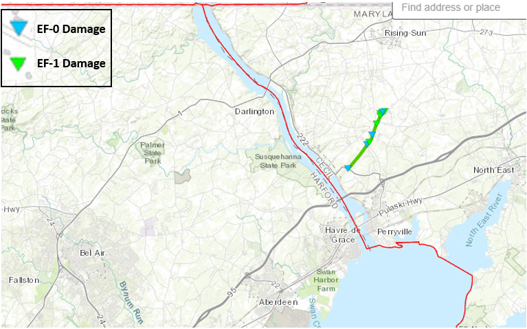
Start Location...Port Deposit in Cecil County, MD
End Location...Woodlawn in Cecil County, MD
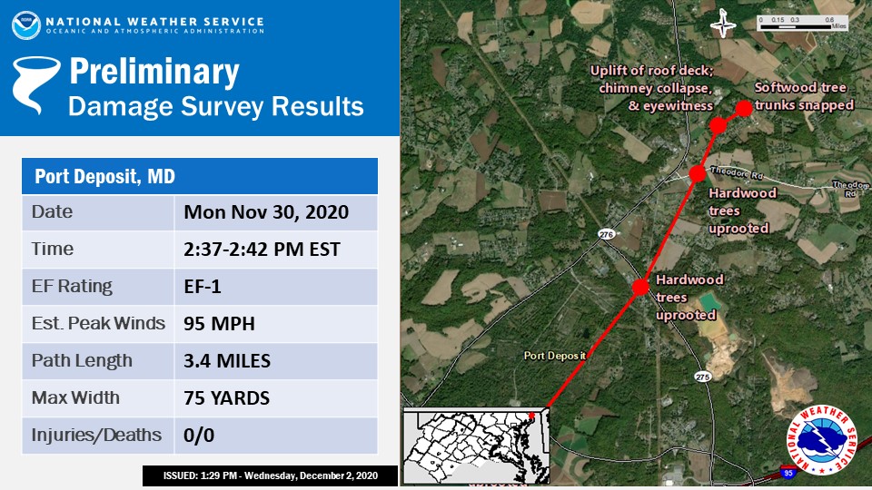
Date...November 30, 2020
Estimated Time...2:37 PM EST to 2:42 PM EST
Maximum EF-Scale Rating...EF1
Estimated Maximum Wind Speed...95 mph
Maximum Path Width...75 yards
Path Length...3.4 miles
Beginning Lat/Lon...39.644/-76.063
Ending Lat/Lon...39.603/-76097
* Fatalities...None
* Injuries...None
...Summary...
Staff from NOAA's National Weather Service (NWS) Baltimore/Washington Weather Forecast Office performed a survey of storm damage that occurred in Cecil County MD from Port Deposit to Woodlawn, on the afternoon of Monday November 30th, 2020. This survey, coupled with radar analysis from the NWS’s KLWX WSR-88D and the FAA's TBWI Doppler Weather Radars, concluded that a tornado rated EF1 on the Enhanced Fujita scale with max winds of 95 mph struck between 2:37 PM and 2:42 PM EST. The tornado had a path length of 3.4 miles producing consistent damage, with a path width of up to 75 yards. The tornado was moving north-northeast at approximately 40 MPH.
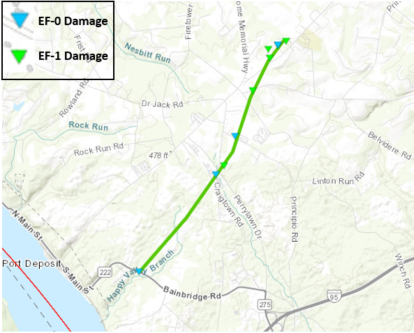
The first reported damage was along Bainbridge Road near the intersection with Frenchtown Road, about 1 mile east of the town center of Port Deposit, MD, where several trees were uprooted and snapped near a residence. Tree damage continued into the woods northeast of the property, where tops of some trees were snapped and twisted. The storm moved to the northeast, uprooting more trees along Craigtown Road near the intersection with Perrylawn Drive. Reports from the day before noted more trees were down prior to our ground survey, but had to be cleared from roadways. Numerous trees were reported down behind the convenience store at that intersection.
The tornado continued towards the northeast through a large field before reaching Jackson Park Road. Along that road there was evidence of powerline damage, where new poles had just been installed near a residence. Additionally, there was tree debris in the yard, but the direction of fall could not be determined in this area. The tornado continued northeast, passing over a residence on Theodore Road where multiple trees were snapped, uprooted, and twisted in multiple directions. Additionally, there was a power pole replaced in front of the home that was confirmed to have been snapped during the tornado.
The tornado strengthened as it continued northeast, and moved into communities along Hopewell Road. The most severe damage noted occurred to homes on Hopewell Court and Bullet Street, where there was structural damage noted to several homes. Damage included shingle and siding damage, and a garage door bent inward.
The strongest wind noted lifted off and removed the front porch awning of one home’s roof. The debris was blown over and behind the home. In addition to the structural damage here, there were several trees uprooted and snapped in various directions. One tree fell onto and crushed a back porch. A resident on Hopewell Court reported seeing the tornado as it went by her home. Based on the damage, winds were estimated to have peaked here at 95 MPH.
Finally, there was tree damage observed along Twin Lakes Road, just northeast of the previous two streets noted. The tornado then moved off into a large field and lifted. At the next crossing of Hopewell Road to the northeast, there were no signs of damage. Therefore, the survey concludes that the path ended in the vicinity of Twin Lakes Road.
The National Weather Service would like to thank Cecil County’s Department of Emergency Services and our NWS weather spotters for their assistance with this survey.
EF Scale: The Enhanced Fujita Scale classifies tornadoes into the following categories:
EF0.........65 to 85 mph
EF1.........86 to 110 mph
EF2.........111 to 135 mph
EF3.........136 to 165 mph
EF4.........166 to 200 mph
EF5.........>200 mph
* The information in this statement is preliminary and subject to change pending final review of the event and publication in NWS Storm Data.


 Coastal Flood
 FAQ
FAQ