
Strong to severe thunderstorms will continue tonight across portions of the Ohio Valley into the Mid-Atlantic. Heavy rains may bring an isolated flash flooding threat over the central Appalachians, particularly in West Virginia. Moderate to heavy snow will continue over portions of northern Minnesota and the Upper Peninsula of Michigan through Tuesday morning. Read More >
...Two tornadoes confirmed on May 30 2019...
Below is a summary of two tornadoes confirmed by the National Weather Service Forecast Office in Sterling, VA, following data analysis and surveys in Frederick and Howard Counties in north central Maryland.
===================================================================================
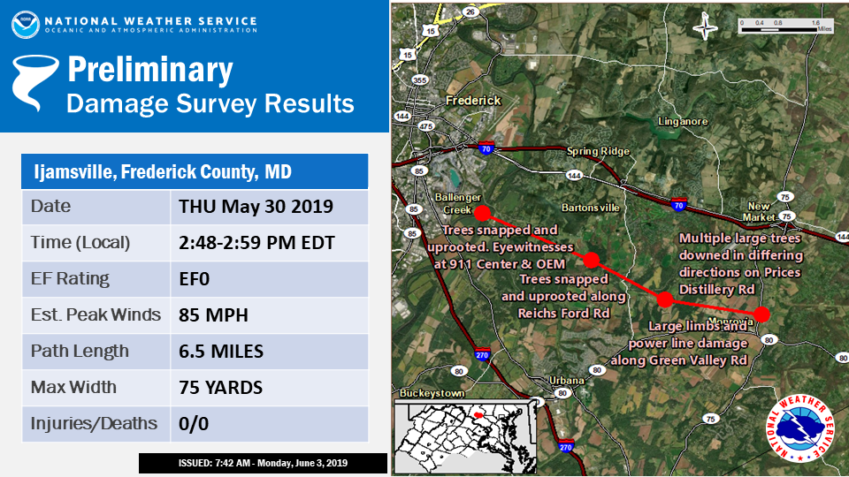
...NWS DAMAGE SURVEY FOR MAY 30 2019 FREDERICK COUNTY TORNADO EVENT...

Start Location...Frederick in Frederick County Maryland
End Location...Monrovia in Frederick County Maryland
Date...May 30 2019
Estimated Time...248 PM EDT to 259 PM EDT
Maximum EF-Scale Rating...EF0
Estimated Maximum Wind Speed...85 mph
Maximum Path Width...75 yards
Path Length...6.5 miles
Beginning Lat/Lon...39.383/-77.382
Ending Lat/Lon...39.357/-77.265

* Fatalities...0
* Injuries...0

...Summary...

Staff from the National Weather Service`s Baltimore/Washington
Forecast Office conducted a storm survey of damage created by a
tornado that occurred on Thursday May 30 2019 near Frederick,
Maryland. The 6.5 mile path of damage extended from the eastern
suburbs of Frederick, through Ijamsville, to Monrovia. The survey
was conducted together with Frederick County`s Office of Emergency
Management, who had aerial video of the western part of the
damage path.

The tornado touched down near the Monocacy River at approximately
248 PM EDT, just west of the Frederick County Public Safety
Training Facility. As it moved east over the county training
facility and property, it snapped and uprooted many trees, but no
structural damage was reported to the building from the wind. Many
county employees in the building witnessed the tornadic rotation.

The tornado tracked a little south of due east, uprooting and
snapping trees along Reichs Ford Road. As it crossed into
Ijamsville, trees were uprooted and large branches were snapped
along Ijamsville Road and Mussetter Road near the Methodist
church.

Continuing east, trees were noted uprooted and large branches
snapped in multiple directions along a path that crossed Prices
Distillery Road, Whiskey Road just south of Whiskey Creek Golf
Course, a new residential community along Ed McClain Road, and
Green Valley Road before lifting at approximately 259 PM EDT.

EF Scale: The Enhanced Fujita Scale classifies tornadoes into the
following categories:

EF0...65 to 85 mph
EF1...86 to 110 mph
EF2...111 to 135 mph
EF3...136 to 165 mph
EF4...166 to 200 mph
EF5...>200 mph

* The information in this statement is preliminary and subject to
change pending final review of the event and publication in NWS
Storm Data.

$$
===========================================================================================================================
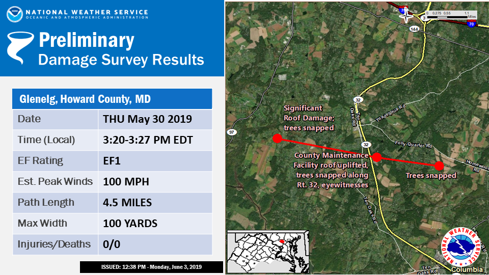
Public Information Statement
National Weather Service Baltimore MD/Washington DC
1213 PM EDT Mon Jun 3 2019

...NWS DAMAGE SURVEY FOR MAY 30 2019 HOWARD COUNTY TORNADO EVENT...

Start Location...Glenelg in Howard County Maryland
End Location...Glenelg in Howard County Maryland
Date...May 30 2019
Estimated Time...320 PM EDT to 327 PM EDT
Maximum EF-Scale Rating...EF1
Estimated Maximum Wind Speed...100 mph
Maximum Path Width...100 yards
Path Length...4.5 miles
Beginning Lat/Lon...39.258/-77.027
Ending Lat/Lon...39.248/-76.944

* Fatalities...0
* Injuries...0

...Summary...

Staff from the National Weather Service`s Baltimore/Washington
Forecast Office conducted a storm survey of damage created by a
tornado that occurred Thursday May 30 2019 near Glenelg, Maryland.
The survey was conducted together with Howard County`s Office of
Emergency Management.

At 3:20 PM EDT, the tornado touched down in a residential community
west of Glenelg between Meriweather Drive and Edgewoods Way. As
the tornado was passing through the community, it ripped sections
of roofing deck off homes. It also snapped and uprooted trees and
large branches, and lofted loose objects hundreds of feet. Moving
east-southeast, it crossed over Tridelphia Road and other nearby
roads, downing large trees and power lines.

As it reached Maryland Route 32 it downed a swath of trees on both
sides of the road before moving over and just north of a Howard
County Highway Maintenance facility. At the facility, the tornado
ripped off its tin roofing, damaged some roof framing, tore a
large section of fabric from a salt dome, destroyed garage bay
doors, damaged fencing, and continued to snap and uproot large
trees along its path. County employees witnessed the rotating
tornado and debris as it crossed the facility.

Continuing along, it snapped and uprooted large trees in residential
areas along Buckskin Lake Drive, Folly Quarter Lane, and Heritage
Hill Lane. It also ripped off a section of barn roofing. The
tornado lifted at 3:27 PM EDT, over a farm property before it
reached Sheppard Lane.

Other isolated tree damage was reported with this severe thunderstorm
away from the main tornadic track. Those downed trees also blocked
roads and downed power lines in the area.

EF Scale: The Enhanced Fujita Scale classifies tornadoes into the
following categories:

EF0...65 to 85 mph
EF1...86 to 110 mph
EF2...111 to 135 mph
EF3...136 to 165 mph
EF4...166 to 200 mph
EF5...>200 mph

* The information in this statement is preliminary and subject to
change pending final review of the event and publication in NWS
Storm Data.

$$


 Coastal Flood
 FAQ
FAQ