
Strong to severe thunderstorms will continue tonight across portions of the Ohio Valley into the Mid-Atlantic. Heavy rains may bring an isolated flash flooding threat over the central Appalachians, particularly in West Virginia. Moderate to heavy snow will continue over portions of northern Minnesota and the Upper Peninsula of Michigan through Tuesday morning. Read More >
Early Season Tornado Outbreak Sweeps Across Mid-Atlantic
Half a dozen tornadoes confirmed across Virginia and Maryland
Summary by Dan Hofmann, Meteorologist at NWS Baltimore/Washington; Individual reports by NWS Staff
An historic tornado outbreak swept across the Mid-Atlantic during the early morning hours of Friday, February 7th, 2020.
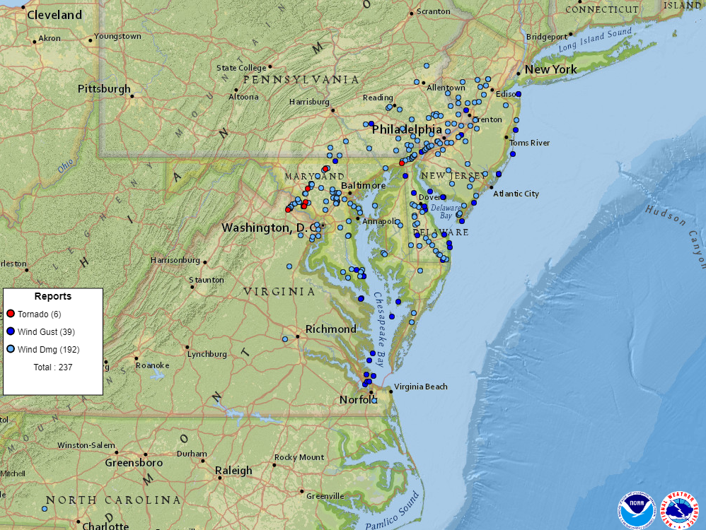
As of early the next morning, over 220 preliminary reports of severe weather had been received from Virginia northeastward into Maryland, Delaware, Pennsylvania and New Jersey, including six confirmed tornadoes.
In just over two hours, five of the confirmed tornadoes struck the state of Maryland, unprecedented for the month of February. Prior to this outbreak, only four tornadoes had ever been reported in the state of Maryland in the month of February since 1950, according to National Weather Service Storm Data. An F1 tornado touched down in Frederick County on February 13th, 1966; an EF0 tornado tracked across parts of St. Mary's and Calvert Counties on February 21st, 2014; another EF0 tornado briefly touched down in St. Mary's County on February 24th, 2016; and an EF1 tornado swept through parts of Charles County on February 25th, 2017.
Unusually warm and humid conditions hugged the region south of a warm front across northern Virginia and north-central Maryland just after daybreak, the product of several days of winds pushing toward the area from the Gulf of America. Meanwhile, extreme winds in the jet stream several thousands of feet above the ground (nearly 200 MPH at 35,000 feet) and a rapidly deepening area of low pressure at the surface tracked directly over the area. The result was a tremendous amount of wind shear and lift caused by feedback between the surface low and the jet stream. The temperature gradient and wind shift across the warm front provided the necessary convergence and spin to initiate and intensify the storms, even in the presence of low convective instability (a more traditional precursor to severe thunderstorms and tornadoes).
Despite the quick moving storms hitting during the morning commute, no fatalities were reported. There was one injury in southern Maryland when straight line winds removed the roof from a small building at a business near Redgate.
Below are summaries of the five tornadoes that were confirmed in the area served by the National Weather Service Weather Forecast Office in Sterling, Virginia. The sixth was in Cecil County, Maryland, which is covered by the Weather Forecast Office in Mount Holly, New Jersey (www.weather.gov/phi). These summaries are preliminary, pending further data analysis and quality control, and ultimately certification and entry into the official National Weather Service Storm Data Archive, which is typically available after 60 days.
=========================================================================================================================
Leesburg, Virginia (EF0)
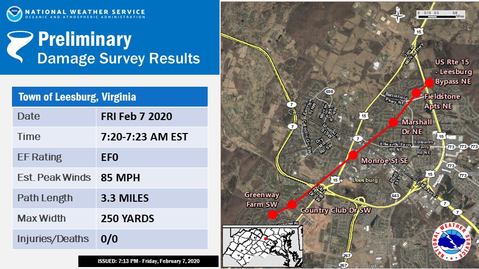
...EF0 TORNADO CONFIRMED IN LEESBURG VIRGINIA FRIDAY MORNING FEB 7 2020...
LOCATION: Town of Leesburg in Loudoun County, Virginia
DATE: Friday, February 7th, 2020
ESTIMATED TIME: 7:20AM to 7:23AM EST
MAXIMUM EF-SCALE RATING: EF0
ESTIMATED MAXIMUM WIND SPEED: 85 MPH
MAXIMUM PATH WIDTH: 250 yards
PATH LENGTH: 3.3 miles
BEGINNING LAT/LON: 39.0946º N, 77.5874º W
ENDING LAT/LON: 39.1291º N, 77.5431º W
* FATALITIES: 0
* INJURIES: 0
...SUMMARY...
Staff from NOAA's National Weather Service Baltimore/Washington Weather Forecast Office located in Sterling, Virginia, performed a survey of storm damage that occurred in the town of Leesburg, Virginia, on the morning of February 7th, 2020. This survey, coupled with radar analysis from the KLWX WSR-88D and the FAA's TIAD Terminal Doppler Weather Radar, concluded that a tornado rated EF0 on the Enhanced Fujita scaled impacted the town of Leesburg between 7:20AM and 7:23AM EST. The tornado had a path length of 3.3 miles producing intermittent damage, with a path width of up to 250 yards. The tornado was moving northeast at approximately 60 MPH.
The first damage was reported in the Greenway Farm and Linden Hill Subdivision in Southwest Leesburg. Here numerous large tree limbs were downed along with several trees completely uprooted. The damage was determined to be concentrated between Lawford Drive and Nickels Drive in a wooded area, and also along Governors Drive and Country Club Drive. TIAD radar was showing a rotational signature beginning at 7:20AM in these locations. Wind gusts in this area were estimated to be 65 MPH from radar analysis and damage indicators.
The tornado then lifted over Route 7, with just some minor tree damage noted in the 800 block of Davis Court SE. The historic downtown portion of the town of Leesburg, near King and Market Streets, was spared with just minimal damage. The only noteworthy damage that was observed was tree damage along Monroe Street.
As the tornado moved into northeast Leesburg, both the radar and the storm survey indicated that it became much stronger. Two areas of widespread, concentrated tree damage were found. The first one was in the vicinity of Lounsberry Road NE and the Exeter Subdivision; which are north of Edwards Ferry Road and south of Battlefield Parkway NE. A townhome on Ginger Square NE had its siding and underlayment completely peeled off, exposing its roof trusses. Many homes along Marshall Drive NE also had roofing damage, along with trees uprooted and large branches downed. One house had lawn furniture lifted and blown in the opposite direction of the way the trees were fallen and debris was plastered on cars and homes. Damage was noted spanning the 500 and 600 blocks of Marshall Drive NE, which supports the damage width estimate of 250 yards.
The other area of concentrated wind damage was north of Battlefield Parkway NE, in and around the Fieldstone Apartment Complex. Here, fifteen to twenty 1.5-2.0 foot diameter pines were uprooted. Of special note was a line of five large pine trees in the easternmost portion of the apartment complex which were uprooted and which fell onto two unoccupied vehicles. Several of these trees did fall in a convergent pattern. Additional large pine trees were uprooted along the US Route 15 Leesburg Bypass near its intersection with Battlefield Parkway NE.
Analysis from TIAD radar showed velocity measurements up to 77 knots at approximately 210 feet above ground level as the tornado was in the vicinity of the Fieldstone Apartments. Taking into account some decrease in the wind's magnitude as it got closer to ground level, along with the damage indicated in and around the
Fieldstone Apartments, corroborates estimated wind gusts of up to 85 MPH. The NWS Baltimore/Washington Weather Forecast Office thanks the Loudoun County Office of Emergency Management for providing information supporting the storm survey.
LEE
=========================================================================================================================
Near Dickerson, Maryland (EF1)
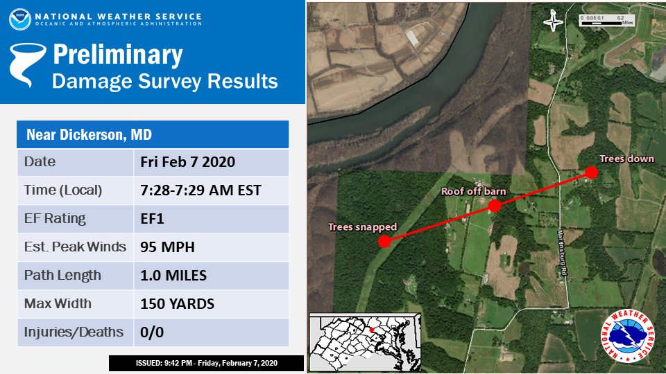
...EF1 TORNADO CONFIRMED NEAR DICKERSON MARYLAND...
LOCATION: Dickerson in western Montgomery County, Maryland
DATE: Friday, February 7th, 2020
ESTIMATED TIME: 7:28AM to 7:29AM EST
MAXIMUM EF-SCALE RATING: EF1
ESTIMATED MAXIMUM WIND SPEED: 95 MPH
MAXIMUM PATH WIDTH: 150 yards
PATH LENGTH: 1.0 mile
BEGINNING LAT/LON: 39.1763º N, 77.4827º W
ENDING LAT/LON: 39.1819º N, 77.4633º W
* FATALITIES: 0
* INJURIES: 0
...SUMMARY...
Staff from NOAA's National Weather Service Baltimore/Washington Weather Forecast Office located in Sterling, Virginia, performed a survey of storm damage that occurred in western Montgomery County, Maryland, near Dickerson. This survey, coupled with radar analysis from the KLWX WSR-88D and an FAA Terminal Doppler Weather Radar (TIAD), concluded that a tornado rated EF1 on the Enhanced Fujita Scale impacted portions of extreme western Montgomery County, Maryland, near Dickerson.
Initial damage was noted in trees just west of a farm near the Potomac River off Martinsburg Road. A large barn used to house horses lost all of its roof while an adjacent open-air pole barn was flattened. Several small outbuildings were destroyed. Bleachers at a horse showing facility were overturned. A metal frame windmill tower was toppled. Numerous trees, both hardwood and softwood, were either uprooted or snapped. Then the tornado moved northeast across open fields. It then crossed Martinsburg Road near a farmhouse where several large trees were uprooted and a farmhouse lost many shingles. No damage was noted past the farm house.
This tornado was not the same one that struck near Lessburg, Virginia, earlier. Rather it was a short-lived tornado that spun up quickly to the northeast of the circulation that spawned the Leesburg, Virginia EF0 tornado.
SMZ/KJP
=========================================================================================================================
Boyds/Dawsonville, Maryland (EF0)
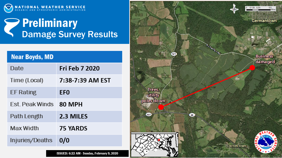
...EF0 TORNADO CONFIRMED NEAR BOYDS MARYLAND......
LOCATION: Boyds in Montgomery County, Maryland
DATE: Friday, February 7th, 2020
ESTIMATED TIME: 7:38AM to 7:39AM EST
MAXIMUM EF-SCALE RATING: EF0
ESTIMATED MAXIMUM WIND SPEED...80 MPH
MAXIMUM PATH WIDTH...75 yards
PATH LENGTH...2.3 miles
BEGINNING LAT/LON...39.1301º N, 77.3464º W
ENDING LAT/LON...39.1431º N, 77.3113º W
* FATALITIES: 0
* INJURIES: 0
...SUMMARY...
Staff from NOAA's National Weather Service Baltimore/Washington Weather Forecast Office located in Sterling, Virginia, performed a survey of storm damage that occurred in west-central Montgomery County, Maryland, near Boyds. This survey, coupled with radar analysis from the KLWX WSR-88D and an FAA Terminal Doppler Weather Radar (TIAD), concluded that a tornado rated EF0 on the Enhanced Fujita Scale impacted portions of west-central Montgomery County, Maryland, near Boyds and Dawsonville.
Initial damage was noted on Darnestown Road (RT 28) between White Ground Road and Sugarland Road where several softwood trees were toppled and fell across utility lines on Darnestown Road.
After passing over largely rural fields and woodlands, the tornado damaged several structures at a dog training facility in the 14000 block of Schaeffer Road. Here, an open facing storage outbuilding was flattened. Roofing material carried from the destroyed outbuilding damaged two other office trailer structures. A 10 foot 2x4 impaled the side of one of the office trailers, while another 2x4 impaled the roof of the second office trailer. Some tree damage was noted just to the northeast of this facility, but all damage ended shortly thereafter.
SMZ/KJP
=========================================================================================================================
Monrovia, Maryland (EF1)
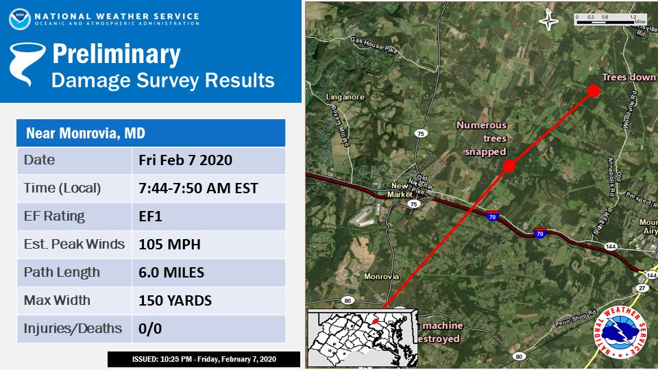
...EF1 TORNADO CONFIRMED IN FREDERICK COUNTY, MARYLAND FRIDAY MORNING FEBRUARY, 7TH 2020...
LOCATION: Monrovia in Frederick County, Maryland
DATE: Friday, February 7th, 2020
ESTIMATED TIME: 7:44AM to 7:50AM EST
MAXIMUM EF-SCALE RATING: EF1
ESTIMATED MAXIMUM WIND SPEED: 105 MPH
MAXIMUM PATH WIDTH: 150 yards
PATH LENGTH: 6.0 MILES
BEGINNING LAT/LON: 39.3427º N, 77.2758º W
ENDING LAT/LON: 39.4155º N, 77.1917º W
* FATALITIES: 0
* INJURIES: 0
...SUMMARY...
Staff from NOAA's National Weather Service Baltimore/Washington Weather Forecast Office located in Sterling, Virginia, performed a survey of storm damage that occurred in eastern Frederick County, Maryland, near Monrovia and New Market. This survey, coupled with radar analysis from the KLWX WSR-88D radar and an FAA Terminal Doppler Weather Radar (TIAD), concluded that a tornado rated EF1 on the Enhanced Fujita Scale impacted portions of eastern Frederick County, Maryland.
Initial damage was to several structures at a farm in the 11000 block of Fingerboard Road, where a machine shed and barn were flattened. A silo was also heavily damaged. Tree damage was noted near the intersection of State Routes 75 and 80. A large swath of tree and utility line damage was noted along Lynn Burke Road near Old Barhtolows Road, just south of I-70.
The tornado crossed I-70 and moved along Jesse Smith Road where more tree damage (uprooted and topped) was observed. Further north along the 12900 block of Jesse Smith Road, more significant tree damage occurred with numerous softwood trees topped at two residences along a concentrated damage path.
The tornado continued northeast over open country before crossing Old Annapolis Road near Ravenwood Road, producing extensive tree damage at several residences. Finally, the tornado caused tree damage as it crossed Bottom Road along Woodville Branch and continued into a wooded area that was not surveyed due to impending darkness.
SMZ/KJP
=========================================================================================================================
Westminster/Manchester, Maryland (EF1)
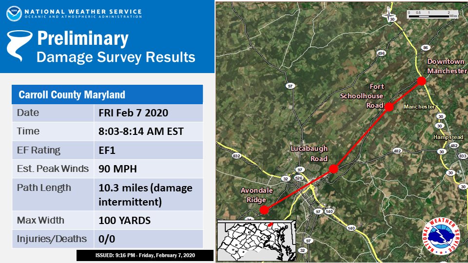
...EF-1 TORNADO CONFIRMED IN CARROLL COUNTY, MARYLAND ON FRIDAY MORNING FEBRUARY, 7TH 2020...
LOCATION: Carroll County, Maryland
DATE: Friday, February 7th, 2020
ESTIMATED TIME: 8:03AM to 8:14AM EST
MAXIMUM EF-SCALE RATING: EF1
ESTIMATED MAXIMUM WIND SPEED: 90 MPH
MAXIMUM PATH WIDTH: 100 yards
PATH LENGTH: 10.3 miles (intermittent)
BEGINNING LAT/LON: 39.5620º N, 77.0310º W
ENDING LAT/LON: 39.6610º N, 76.8860º W
* FATALITIES: 0
* INJURIES: 0
...SUMMARY...
Early on Friday, February 7th, a tornado touched down and skipped northeast across central Carroll County, Maryland, causing erratic damage. While there was scattered tree damage across southwestern Carroll County, the first noted damage consistent with a tornado was in the Avondale Ridge Community just west of Route 31 and southwest of Westminster. Clusters of snapped and uprooted trees were noted. From there, the tornado caused intermittent damage as it traveled northeast through downtown Westminster, roughly paralleling Ridge Road and Union Street. Trees were uprooted and snapped, some onto cars, roads and homes. Additionally, roofing was blown off, and shingle and siding damage was noted from the wind. The tornado continued up Hahn Road and into the community along Sunshine Way, where more snapped and uprooted trees were noted, as well as residential fencing damage. A large recreational vehicle was blown over. On adjacent property, the National Guard recruiting office had tree damage. Additionally, a small military trailer was blown over. The last known damage from this segment of the tornado was along Lucabaugh Mill Road, about 250 yards west of Route 27/Manchester Road. Most of the trees along this area were heavily damaged or downed. In addition to ground surveying, there was an eyewitness report, as well as video of a small tornado posted to social media, both in the Westminster area. Peak estimated winds were 90 MPH based on the most heavily damaged areas.
The tornado lifted northeast of Westminster, and no damage was noted for about 4 miles until it neared Manchester, Maryland. Substantial tree damage, with numerous large trees uprooted and snapped, were noted along Fort Schoolhouse Road, from Albert Rill Road, to the northeast about 400 yards. A home had a section crushed by a large falling tree. As the tornado traveled northeast along Park Avenue, tree damage became more scattered, and no tornadic damage was noted northeast of MD Route 30 in Manchester.
Thanks to Carroll County, Maryland, Office of Emergency Management for their support of our storm survey.
STRONG/LEE
=========================================================================================================================
EF Scale: The Enhanced Fujita Scale classified tornadoes into the following categories:
EF0: 65 to 75 MPH
EF1: 86 to 110 MPH
EF2: 111 to 135 MPH
EF3: 136 to 165 MPH
EF4: 166 to 200 MPH
EF5: >200 MPH
* The information in these statements is preliminary and subject to change pending final review of
the event and publication in NWS Storm Data.


 Coastal Flood
 FAQ
FAQ