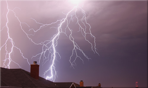
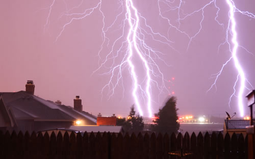
Picture of cloud-to-ground Lightning in South Lubbock on the night of Thursday, June 19th. Photo by Todd Lindley
Active Weather for the Middle and End of June 2008
The middle and end of June has been an active one for the South Plains of West Texas, with showers and thunderstorms found somewhere in the area everyday from the 14th of June onward through the end of the month. The active weather has been a result of a number of factors. The first couple of the days (14-16 June), very hot temperatures, with highs soaring into the upper 90s and lower triple digits, combined with sufficient moisture to produce isolated to widely scattered high based thunderstorms. One particularly strong isolated supercell thunderstorm generated very large hail and strong winds in the Childress area, causing extensive damage the evening of Sunday, June 15th.
Below you will find three tables that contain a series of 24-hour radar estimated precipitation totals generated from the Lubbock radar for the middle and end of June. Although the exact values of the rainfall estimates are not to be taken as truth (as they often too high, due to hail contamination, among other problems), they do give a good feel with regards to the general coverage of precipitation each day. The images immediately below indicate that precipitation was initially limited mostly to the eastern part of the area, where the higher amounts of moisture were located.
 |
 |
 |
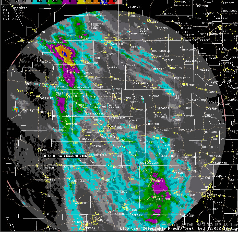 |
| Sequence of 24-hr radar estimated precipitation totals from the Lubbock WSR-88D radar between June 14th and 17th, 2008. Although the exact precipitation amounts are often too large (especially in areas where hail fell), the depiction does give a good representation with regards to the precipitation coverage. Click on the images for a larger view. | |
By the 17th, temperatures cooled down below average and low level moisture levels improved as outflow air from thunderstorms to the east moved through the area. Along with the improved low-level moisture, a"northwest flow"-type upper air weather pattern became established across the region in mid-June. The improved moisture and southeasterly winds at ground level combined with the persistent northwest flow aloft to create a pattern conducive for the repeated occurrence of evening and nighttime thunderstorms moving out of northeastern New Mexico and into West Texas. The northwest flow pattern is one where a ridge of warm air and high pressure aloft settles in across the desert southwest. Eastward-moving air from the Pacific is diverted around this high pressure dome across the 4-corners region and through the central Rocky Mountains. Then, once it reaches the east side of the ridge, it turns to the southeast. This is what directs storms which develop in the afternoon along the high terrain of Colorado and New Mexico into West Texas. When sufficient moisture is in place, and it is fed directly into the storms coming off the mountains on southeast winds, these thunderstorms are apt to grow in coverage and persist well into the night as they continue on their trek to the southeast.
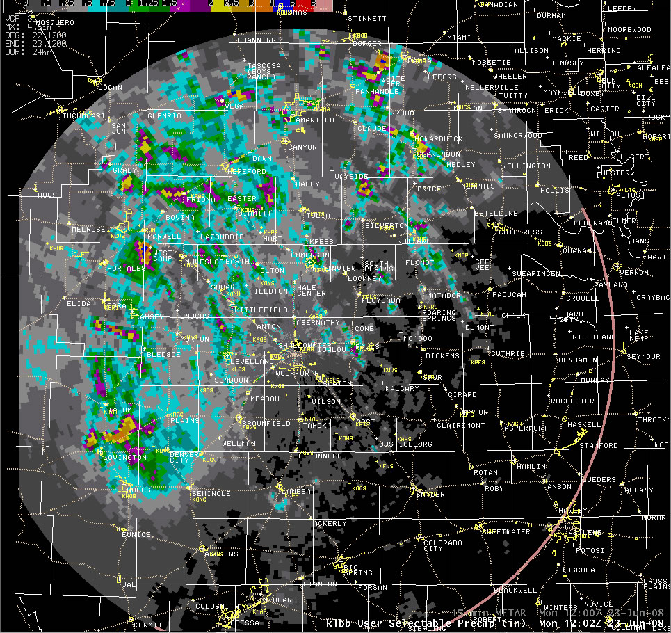
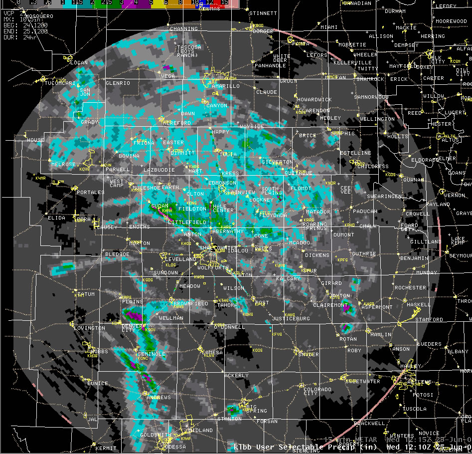
The below images indicate the general precipitation coverage between the 18th and 25th of June, when moderate mid-level northwest flow remained in place over the region. Although the exact coverage and intensity of the precipitation from day to day varied (due to many factors), a majority of these days did see fairly widespread coverage, with locations on the Caprock, closer to the thunderstorm source region, generally favored.
 |
 |
 |
 |
 |
 |
 |
 |
| Sequence of 24-hr radar estimated precipitation totals from the Lubbock WSR-88D radar between June 18th and 25th, 2008. Although the exact precipitation amounts are often too large (especially in areas where hail fell), the depiction does give a good representation with regards to the precipitation coverage. Click on the images for a larger view. | |
Toward the end of June the northwest flow finally broke down, and the steer winds became very weak, thus making it difficult for storms that formed near the mountains to make it all the way to West Texas. Still, a few storms still did develop across the western South Plains and southwest Texas Panhandle along a surface trough during the afternoon and evening hours, but overall coverage diminished. The exception was the 28th, when a cold front moved into the area. This front helped to lift a relatively moist air mass, resulting in fairly widespread rains, some which were on the heavy side. More scattered rainfall did persist across the southern sections on the 29th, with isolated activity on the 30th (not shown). However, the rainfall at the end of the month was not due to northwest flow. Instead, the rain moved westward, and was a result of an upper level low that developed and remained nearby to the south.
 |
 |
 |
 |
| Sequence of 24-hr radar estimated precipitation totals from the Lubbock WSR-88D radar between June 26th and 29th, 2008. Although the exact precipitation amounts are often too large (especially in areas where hail fell), the depiction does give a good representation with regards to the precipitation coverage. Click on the images for a larger view. | |
In addition to consistent rainfall in the area through the second half of June, a number of the thunderstorms did bring some severe weather to the region, with many of the days producing at least isolated severe weather. Below is a list of the preliminary storm reports collected here in the Lubbock office over the period. Days without any severe weather reports are omitted.
|
Preliminary Storm Reports (14-26 June)
|
|||
|
|
|||
Even though severe weather was observed a majority of the days through the period, a few stood above the rest in terms of severity. In addition to the strong winds and large hail that impacted Childress on the 15th, a few very intense storms tracked almost due south from the extreme southwest Texas Panhandle through the western South Plains on the 17th. These storms brought baseball to softball size hail to Friona, Muleshoe and Plains. The softball sized hail broke windshields and even punctured mobile homes in the Muleshoe area.
The 19th brought widespread severe weather, with numerous wind gusts over 60 mph measured, many reports of golf ball sized hail, and even one brief tornado touchdown observed north of Paducah. This day also brought the very intense lightning displays that are featured on this page.
Additionally, the 23rd and 24th brought thunderstorm complexes that produced numerous severe wind reports across portions of the central and western South Plains. All in all, a pretty active late spring and early summer for the region.
A second picture of cloud-to-ground Lightning in South Lubbock on the night of Thursday, June 19th. Photo by Todd Lindley.

