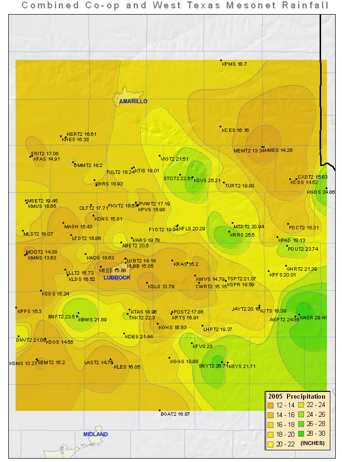
Unlike 2004, precipitation was scarce during the end of 2005. In fact, the Lubbock airport only recorded a trace of precipitation in both November and December, ending the year with 65 days without measurable precipitation.
|
LUBBOCK
|
Average High
|
Average Low
|
Precip (inches)
|
|
January
|
55.1
|
31.8
|
1.33
|
|
February
|
56.8
|
35.1
|
1.32
|
|
March
|
64.2
|
36.7
|
0.73
|
|
April
|
74.8
|
44.0
|
0.27
|
|
May
|
80.8
|
57.2
|
2.24
|
|
June
|
92.6
|
65.4
|
1.84
|
|
July
|
91.7
|
67.1
|
2.42
|
|
August
|
88.7
|
65.5
|
2.01
|
|
September
|
89.7
|
62.2
|
0.28
|
|
October
|
74.3
|
49.5
|
2.61
|
|
November
|
68.4
|
35.0
|
T
|
|
December
|
56.7
|
26.1
|
T
|
|
Annual
|
74.6 (avg)
|
48.0 (avg)
|
15.05 (total)
|
|
Normal
|
73.2
|
46.2
|
18.69
|
|
Departure
|
1.4
|
1.8
|
-3.64
|
JANUARY:
4th: Thunderstorms produced 1" and 0.75" diameter hail near Lubbock and Brownfield, respectively.
30th: Hail, up to golfball-sized, was reported in central Bailey county (about 15 mile SSW of Muleshoe).
FEBRUARY :
1st: A potent upper-level storm system brought snowfall to much of the South Plains, with the southeastern South Plains receiving the heaviest amounts. Specifically, portions of Lynn, Garza and Crosby counties received 5 to 8 inches, with the NWS Weather Forecast Office in Lubbock recording 1.7 inches.
MARCH:
15th: Heavy snow fell across much of the southern Texas Panhandle and northern South Plains, resulting in about a half a foot of snow reported across much of the area (including Pep, Plainview, Aiken, Silverton, Tulia, Springlake, Muleshoe and Friona). The big winner was Dimmitt, where 8 to 10 inches fell.
26th: Another round of snow fell across the southwest Texas Panhandle and northwest South Plains, with Vigo Park recording 7 inches. Please read more HERE.
APRIL:
5-6th: A powerful upper-level storm system moving across the Texas Panhandle produced strong winds across the southern Texas Panhandle, South Plains and Rolling Plains for nearly 36 continuous hours. Wind speeds generally topped out near 60 mph, with a maximum gust of 62 mph recorded by the West Texas Mesonet located near White River Lake.
18th: Severe thunderstorms producing hail and high winds moved through portions of the southern Texas Panhandle and northern South and Rolling Plains. Golfball-sized hail was reported 6 miles west of Matador.
20th: Severe thunderstorms moved across Briscoe and Hall counties, with hail up to the size of a baseball reported 8 miles north of Turkey.
MAY:
10th: Severe thunderstorms moved across the western and central counties of the South Plains and southwest Texas Panhandle. Locations at Littlefield, a mile west of Pep and a mile west of Whiteface all reported golfball sized hail. Additionally, a number of location reported severe wind gusts, with Brownfield recording the highest gust at 79 mph.
12-13th: An outbreak of Severe Weather occurred across portions of the South and Rolling Plains and Texas Panhandle. Nine tornadoes were confirmed through this period, with an F3 tornado observed southwest of Ralls, an F2 tornado west of Ralls, and another F2 tornado observed near South Plains. Also, softball-sized hail was observed near South Plains and north of Lockney. Please read more HERE. Also, NWS Lubbock won an award for its performance during this outbreak. If you would like to read about it, click HERE.
31st: A couple rounds of severe thunderstorms impacted the region, including golfball-sized hail around 5:30 am in Lubbock. For a more complete summary of the event click HERE.
JUNE:
5th: Numerous hail and several high wind reports were received, including softball-sized hail near Wilson and a 78 mph wind gust caused by a heat burst at Jayton.
9th: Proficient hail producing storms moved across the central South Plains during the late afternoon, before one supercell thunderstorms took over by evening. The earlier storms produced up to grapefruit-sized hail 4 miles northeast of Abernathy. The supercell then generated large hail, tornadoes, and flash flooding. One of the tornadoes was rated an F3 due to significant damage it did in the vicinity of McCoy. Click HERE to learn more.
11th: A supercell thunderstorm produced three short lived tornadoes northwest of Vigo Park. Click HERE for more details.
12th: A total of 10 tornadoes occurred in the Lubbock County Warning Area (CWA) from a couple of supercell thunderstorms. One of the tornadoes that occurred northeast of Clairemont became very large (0.6 to 0.7 miles wide) was rated an F2 after assessing large farm equipment (tractors and cotton trailers) that were tossed and mangled. To learn more click HERE.
16th: Thunderstorms produced golfball-sized hail 7 miles west of Lazbuddie, with more widespread small hail reports and severe wind gusts.
JULY:
1st: Severe thunderstorms impacted portions of the South and Rolling Plains. Some highlights were 1” hail at Farwell and a 69 mph wind gust at Spur, which downed some power poles.
5th: Severe thunderstorms brought strong winds to portions of the central and western South Plains, including a thunderstorm wind gust to 69 mph wind gust at Anton, which snapped several large tree limbs and blew the roof off a manufactured home. Additionally, several power lines and large trees were downed near Levelland.
9th: A thunderstorm brought golf ball-sized hail to Roaring Springs.
AUGUST:
4-5th: Flash flooding occurred in Lynn and Garza counties. The heavy rains prompted the closure of numerous roads around Post and Tahoka.
8th: Golfball-sized hail was reported in Bailey county 4 miles west of Enochs.
11-16th: Heavy rain fell across much of the region. Click HERE for more details.
19-22nd: Heavy rains fall on the Northwest South Plains and Southern Texas Panhandle. To learn more click HERE.
27th: An outbreak of severe thunderstorms brought large hail, high winds and flash flooding to portions of the South Plains. Click HERE to learn more.
SEPTEMBER:
14th: Hail up to the size of golf balls fell from a round of thunderstorms across Lynn, Garza, Dickens and Kent Counties. Additionally, strong winds (measured up to 71 mph at the West Texas Mesonet station located 10 miles southwest of Paducah) downed several large trees near Paducah and Dumont.
17th: Severe weather and heat burst events impacted the South Plains. Click HERE for details.
OCTOBER:
October started out with a couple of rounds of rain, but quickly dried out, with only 0.20 of an inch observed at the Lubbock airport for the 11th on. The last measurable precipitation of 2005 was recorded at the Lubbock airport on October 27, when 0.02 fell.
NOVEMBER:
15th: Strong north winds affected the Panhandles, South Plains, and Rolling Plains. To learn more click HERE.
16th: Most locations experienced the first hard freeze of the fall. See more HERE.
27th: Strong winds (gusting above 50 mph across many location) brought blowing dust to much of the area. To learn more click HERE.
Note: No appreciable rain fell across the region, with the Lubbock airport recording only a trace.
DECEMBER:
NOTE: No appreciable rain fell across most of the region. However, a number of locations did record very light precipitation when fog and light drizzle and freezing drizzle blanketed the area mid-month. The Lubbock airport only recorded a trace of precipitation for the second straight month.


