Lubbock, TX
Weather Forecast Office
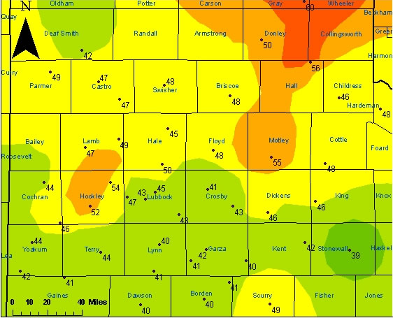
| Image of the highest wind gusts (mph) recorded across the region from the morning and early afternoon on November 15, 2005. Wind gusts over 50 mph are generally in orange, with weaker winds in green and yellow. The above image was created with data from the Texas Tech West Texas Mesonet. County names are also displayed. |
STRONG NORTH WINDS AFFECTED THE SOUTHERN PANHANDLE...SOUTH PLAINS
AND ROLLING PLAINS EARLY THIS MORNING IN THE WAKE OF A POWERFUL
CANADIAN COLD FRONT. THE FOLLOWING IS A LIST OF TEXAS TECH WEST
TEXAS MESONET STATIONS AND OTHER LOCATIONS THAT EXPERIENCED WIND
SPEEDS AT OR ABOVE 45 MPH.


ABERNATHY 5NE       50 MPH
AMHERST 1NE         47 MPH
ANTON 6S            54 MPH
CHILDRESS AIRPORT   46 MPH
CLARENDON 2W        50 MPH
DIMMITT 2NE         47 MPH
FLOYDADA 2NE        48 MPH
FRIONA 2NE          49 MPH
GOODLETT 3W         48 MPH
GUTHRIE 10W         46 MPH
HART 3N             47 MPH
LEVELLAND 4S        52 MPH
LUBBOCK AIRPORT     45 MPH
LUBBOCK (REESE CTR) 47 MPH
MCLEAN 1E           60 MPH
MEMPHIS 1NE         56 MPH
OLTON 6S            49 MPH
PAMPA 2E            58 MPH
PADUCAH 10SW        48 MPH
PLAINVIEW 1S        45 MPH
ROARING SPRINGS 3N  55 MPH
SILVERTON 7E        48 MPH
SNYDER 3E           49 MPH
SPUR 1W             46 MPH
SUNDOWN 8SW         46 MPH
TULIA 2NE           48 MPH
US Dept of Commerce
National Oceanic and Atmospheric Administration
National Weather Service
Lubbock, TX
2579 S. Loop 289
Suite 100
Lubbock, TX 79423-1400
806-745-4260
Comments? Questions? Please Contact Us.

