Overview
During the overnight hours of Friday, July 22 into Saturday, July 23, thunderstorms developed across portions of Winnebago, Boone, McHenry, and Lake counties in northern Illinois. These initial thunderstorms trained, or re-developed continuously, over the same areas for several hours which led to significant flash flooding across parts of Lake County. As these storms moved to the southeast, they dropped copious rainfall over these same counties with parts of Lake and McHenry counties quickly picking up 2-6+ inches of rain, in part due to precipitable water (PWAT) values in excess of 1.5 inches during the overnight hours. In addition to the heavy rain, the storms initially dropped hail up to 1.75 inches in diameter in Lake and McHenry Counties. This hail was also accompanied by strong winds which brought down trees and damaged roofs in some areas. As the night went on, more storms began to fire near the Freeport/Rockford area and moved off towards the southeast. These storms sporadically dropped large hail and produced scattered damaging wind gusts near the I-88 corridor. Eventually, as the storms continued to congeal together towards daybreak, they developed into a Quasi-Linear Convective System (QLCS) as they moved into the Chicago metro. A few areas of embedded rotation eventually developed within this line of storms, and one of these areas of rotation went on to produce a cyclic path of 3 brief tornadoes in Will County. In the process, these storms continued to produce scattered strong wind gusts and large hail as they moved off to the east and southeast. As the initial storms moved out of the area, they left behind a boundary upon which additional storms developed through the morning and early afternoon hours. These storms produced up to a few additional inches of rainfall along and south of a Dixon to Joliet to Rensselaer line along with isolated instances of hail up to 1.75 inches in diameter. As the morning and early afternoon storms died off and moved out of the region, it was quiet within the area until late in the night when the final round of storms arrived from the west. These storms were a bit weaker than the previous rounds of storms but still produced a few damaging wind gusts and added to the high rainfall totals in already soaked areas. |
Storm Reports
 |
 |
|
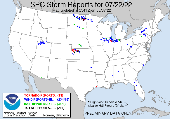
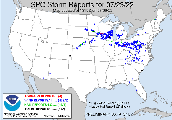
National Storm Reports for July 22nd, 2022 through 7 AM CDT on July 23rd |
PRELIMINARY LOCAL STORM REPORT...SUMMARY
NATIONAL WEATHER SERVICE CHICAGO IL
745 PM CDT TUE JUL 26 2022
..TIME... ...EVENT... ...CITY LOCATION... ...LAT.LON...
..DATE... ....MAG.... ..COUNTY LOCATION..ST.. ...SOURCE....
..REMARKS..
1105 PM HAIL 1 W IRVING PARK - CHICA 41.95N 87.74W
07/22/2022 M1.00 INCH COOK IL PUBLIC
PHOTO SHARED ON SOCIAL MEDIA SHOWING QUARTER
SIZE HAILSTONE IN OLD IRVING PARK. SEVERAL
OTHER REPORTS OF HALF INCH TO QUARTER SIZE
HAIL IN THE IRVING PARK AND ALBANY PARK
NEIGHBORHOODS OF CHICAGO.
1111 PM HAIL 1 NW LINCOLN PARK - CHI 41.93N 87.66W
07/22/2022 E0.88 INCH COOK IL PUBLIC
MULTIPLE REPORTS OF HALF INCH TO NICKEL SIZE
HAIL ACROSS THE NORTH SIDE OF CHICAGO,
INCLUDING IN THE LAKEVIEW, LOGAN SQUARE, AND
LINCOLN PARK NEIGHBORHOODS.
1122 PM MARINE TSTM WIND 3 NE NAVY PIER 41.92N 87.57W
07/22/2022 M43 MPH LMZ741 IL C-MAN STATION
PEAK GUST AT HARRISON-DEVER CRIB WITH
INITIAL STORM.
1220 AM TSTM WND DMG 1 SSE SPRING GROVE 42.43N 88.23W
07/23/2022 MCHENRY IL TRAINED SPOTTER
DELAYED REPORT... TREES AND LARGE TREE LIMBS
DOWNED IN SPRING GROVE.
1228 AM HAIL LAKE VILLA 42.42N 88.08W
07/23/2022 E1.00 INCH LAKE IL PUBLIC
MULTIPLE REPORTS OF NICKEL TO QUARTER SIZE
HAIL IN LAKE VILLA. TIME ESTIMATED FROM
RADAR.
1235 AM HAIL 1 WNW ZION 42.45N 87.85W
07/23/2022 E0.75 INCH LAKE IL TRAINED SPOTTER
PHOTO SHARED VIA SOCIAL MEDIA.
1259 AM HAIL ISLAND LAKE 42.27N 88.19W
07/23/2022 M1.00 INCH LAKE IL TRAINED SPOTTER
TIME ESTIMATED FROM RADAR.
0100 AM HAIL MCHENRY 42.34N 88.28W
07/23/2022 M1.00 INCH MCHENRY IL PUBLIC
MULTIPLE REPORTS OF NICKEL TO QUARTER SIZE
HAIL IN MCHENRY.
0114 AM TSTM WND DMG LAKEMOOR 42.33N 88.19W
07/23/2022 LAKE IL PUBLIC
DELAYED REPORT... TREES WERE BLOWN DOWN AND
ROOF SHINGLES WERE BLOWN OFF. TIME ESTIMATED
FROM RADAR.
0114 AM HAIL LAKEMOOR 42.33N 88.20W
07/23/2022 E1.75 INCH LAKE IL PUBLIC
DELAYED REPORT... HAIL BROKE EXTERIOR
LIGHTS. TIME ESTIMATED FROM RADAR.
0120 AM HAIL MUNDELEIN 42.27N 88.00W
07/23/2022 E1.00 INCH LAKE IL PUBLIC
MULTIPLE REPORTS OF PENNY TO QUARTER SIZE
HAIL IN MUNDELEIN.
0120 AM TSTM WND DMG 1 W LONG LAKE 42.37N 88.15W
07/23/2022 LAKE IL DEPT OF HIGHWAYS
DELAYED: ROUTE 134 CLOSED DUE TO FALLEN
TREE, BETWEEN WILSON AND CAMBRIDGE. TIME
ESTIMATED (VARIABLE) BY RADAR.
0121 AM HAIL ROUND LAKE 42.36N 88.09W
07/23/2022 M1.00 INCH LAKE IL PUBLIC
PHOTO SHARED ON SOCIAL MEDIA SHOWING QUARTER
SIZE HAIL IN ROUND LAKE. TIME ESTIMATED FROM
RADAR.
0122 AM HAIL HAINESVILLE 42.35N 88.07W
07/23/2022 E0.88 INCH LAKE IL PUBLIC
0122 AM HAIL ROUND LAKE BEACH 42.38N 88.09W
07/23/2022 M1.00 INCH LAKE IL PUBLIC
PHOTO SHARED ON SOCIAL MEDIA SHOWING QUARTER
SIZE HAIL IN ROUND LAKE BEACH. TIME
ESTIMATED FROM RADAR.
0123 AM HAIL GRAYSLAKE 42.34N 88.04W
07/23/2022 E1.50 INCH LAKE IL PUBLIC
PHOTO SHARED ON SOCIAL MEDIA SHOWING HAIL
APPROXIMATELY 1.5 INCHES IN DIAMETER IN
GRAYSLAKE. TIME ESTIMATED FROM RADAR.
0145 AM HAIL PARK CITY 42.35N 87.88W
07/23/2022 M1.00 INCH LAKE IL PUBLIC
PHOTO RECEIVED VIA TWITTER.
0146 AM HAIL ROUND LAKE 42.35N 88.09W
07/23/2022 E1.00 INCH LAKE IL PUBLIC
FROM SECOND STORM THAT PASSED THROUGH ROUND
LAKE.
0330 AM FLASH FLOOD 1 S GREEN OAKS 42.28N 87.91W
07/23/2022 LAKE IL DEPT OF HIGHWAYS
DELAYED: I-94 NEAR PARK AVE WAS CLOSED DUE
TO FLOODING. TIME ESTIMATED (VARIABLE) BY
RADAR.
0400 AM FLASH FLOOD 2 W LAKE BLUFF 42.28N 87.87W
07/23/2022 LAKE IL 911 CALL CENTER
DELAYED: MAJOR FLOODING IN THE 41/176
VIADUCT. POLICE REPORTED ON SCENE AND IDOT
EN ROUTE WITH BARRICADES. A FEW CARS
STRANDED. TIME ESTIMATED (VARIABLE) BY
RADAR.
0400 AM FLASH FLOOD 1 W LAKE BLUFF 42.28N 87.85W
07/23/2022 LAKE IL BROADCAST MEDIA
DELAYED: SEVERAL FEET OF WATER REPORTED ON
ROADWAY. TIME ESTIMATED (VARIABLE) BY RADAR.
0400 AM FLOOD 1 SW LAKE FOREST 42.25N 87.86W
07/23/2022 LAKE IL BROADCAST MEDIA
DELAYED: SEVERAL INCHES OF STANDING WATER
REPORTED. TIME ESTIMATED (VARIABLE) BY
RADAR.
0400 AM FLASH FLOOD 2 WNW LAKE BLUFF 42.29N 87.87W
07/23/2022 LAKE IL BROADCAST MEDIA
DELAYED: SEVERAL FEET OF WATER REPORTED ON
ROADWAY. TIME ESTIMATED (VARIABLE) BY RADAR.
0400 AM FLASH FLOOD 2 SSW GAGES LAKE 42.32N 88.00W
07/23/2022 LAKE IL DEPT OF HIGHWAYS
DELAYED: US-45/CASEY ROAD WAS CLOSED DUE TO
FLOODING. TIME ESTIMATED (VARIABLE) BY
RADAR.
0421 AM TSTM WND DMG POLO 41.98N 89.58W
07/23/2022 OGLE IL TRAINED SPOTTER
SEVERAL 3 INCH DIAMETER TREE LIMBS AND ONE
20 FOOT LONG, 6 INCH DIAMETER TREE LIMB
DOWNED. TIME ESTIMATED FROM RADAR.
0424 AM MARINE TSTM WIND 1 NE MONTROSE HARBOR 41.97N 87.63W
07/23/2022 M48 MPH LMZ741 IL MESONET
MESONET STATION XMTB MONTROSE BEACH LIGHT
PEAK GUST.
0432 AM MARINE TSTM WIND 3 NE NAVY PIER 41.92N 87.57W
07/23/2022 M58 MPH LMZ741 IL C-MAN STATION
PEAK GUST AT HARRISON-DEVER CRIB WITH SECOND
ROUND OF STORMS.
0439 AM TSTM WND GST 2 ESE DIXON 41.83N 89.45W
07/23/2022 M44 MPH LEE IL AWOS
C739 AWOS (DIXON AIRPORT) PEAK GUST.
0500 AM TSTM WND DMG LONG GROVE 42.18N 88.00W
07/23/2022 LAKE IL DEPT OF HIGHWAYS
DELAYED: ROAD CLOSED DUE TO FALLEN TREE AT
OLD MCHENRY AND CUBA. TIME ESTIMATED
(VARIABLE) BY RADAR.
0505 AM TSTM WND DMG CHESTERTON 41.61N 87.06W
07/23/2022 PORTER IN PARK/FOREST SRVC
CORRECTS PREVIOUS TSTM WND DMG REPORT FROM
CHESTERTON. [DELAYED REPORT] LARGE TREE LIMB
DOWN ON SOUTH PARK DRIVE WEST OF PORTER
AVENUE. TIME ESTIMATED BASED ON RADAR. PHOTO
FROM TOWN FACEBOOK PAGE.
0505 AM TSTM WND DMG ASHTON 41.87N 89.22W
07/23/2022 LEE IL PUBLIC
VIDEO SHARED ON SOCIAL MEDIA SHOWS SEVERAL
LARGE TREE BRANCHES AND TREE LIMBS DOWNED IN
ASHTON. TIME ESTIMATED FROM RADAR.
0506 AM TSTM WND DMG 1 ESE CHESTERTON 41.61N 87.05W
07/23/2022 PORTER IN PARK/FOREST SRVC
[DELAYED REPORT] LARGE TREES DOWN IN THE
VICINITY OF S 2ND STREET AND W MORGAN
AVENUE. BROUGHT WIRES AND POWER POLES DOWN.
TIME ESTIMATED BASED ON RADAR. PHOTO FROM
TOWN FACEBOOK PAGE.
0515 AM TSTM WND DMG ROCHELLE 41.92N 89.07W
07/23/2022 OGLE IL TRAINED SPOTTER
SEVERAL TREES AND 4-6 INCH DIAMETER BRANCHES
DOWNED IN ROCHELLE. TIME ESTIMATED BASED ON
KRPJ AWOS PEAK GUST.
0515 AM TSTM WND GST 2 SSW ROCHELLE 41.89N 89.08W
07/23/2022 M58 MPH OGLE IL AWOS
KRPJ AWOS PEAK GUST.
0517 AM TSTM WND DMG NILES 42.03N 87.80W
07/23/2022 COOK IL PUBLIC
LARGE TREE LIMBS DOWNED IN NILES. TIME
ESTIMATED FROM RADAR.
0518 AM TSTM WND GST OHARE AIRPORT 41.98N 87.90W
07/23/2022 M58 MPH COOK IL ASOS
CORRECTION TO TIME. PEAK THUNDERSTORM WIND
GUST AT OHARE AIRPORT.
0527 AM TSTM WND GST 2 W SUGAR GROVE 41.77N 88.48W
07/23/2022 M54 MPH KANE IL ASOS
ASOS STATION KARR SUGAR GROVE - AURORA ARPT.
0532 AM TSTM WND DMG 1 WNW DEKALB 41.93N 88.78W
07/23/2022 DE KALB IL CO-OP OBSERVER
A COUPLE OF TREE BRANCHES ABOUT 3-6 INCHES
IN DIAMETER WERE DOWNED NEAR THE NIU COOP
STATION. TIME ESTIMATED BASED ON KDKB AWOS
PEAK GUST.
0535 AM TSTM WND GST 1 NNW CORTLAND 41.93N 88.70W
07/23/2022 M48 MPH DE KALB IL AWOS
KDKB AWOS PEAK GUST.
0540 AM TORNADO 5 SW NAPERVILLE 41.71N 88.20W
07/23/2022 WILL IL NWS STORM SURVEY
AN NWS STORM SURVEY DETERMINED THAT AN EF-0
TORNADO WITH ESTIMATED PEAK WINDS OF 85 MPH
TOUCHED DOWN IN FAR SOUTHEASTERN AURORA
BEFORE TRACKING SOUTHEASTWARD INTO
NAPERVILLE.
0552 AM TORNADO 2 N CREST HILL 41.59N 88.10W
07/23/2022 WILL IL NWS STORM SURVEY
AN NWS STORM SURVEY DETERMINED THAT AN EF-0
TORNADO WITH ESTIMATED PEAK WINDS OF 70 MPH
TOUCHED DOWN IN FAR SOUTHERN ROMEOVILLE AND
TRACKED SOUTHWARD THROUGH CREST HILL AND
INTO JOLIET BEFORE LIFTING. FOOTAGE FROM A
CONSTRUCTION CAMERA AT LEWIS UNIVERSITY
AIRPORT SHOWED THAT THIS TORNADO LIFTED AT
LEAST ONCE AND WAS NOT CONTINUOUSLY ON THE
GROUND FOR THE ENTIRE LENGTH OF ITS TRACK.
0553 AM TSTM WND DMG ROMEOVILLE 41.65N 88.10W
07/23/2022 WILL IL PUBLIC
LARGE TREE BRANCHES AND TREE LIMBS DOWNED IN
ROMEOVILLE. TIME ESTIMATED FROM RADAR.
0555 AM TSTM WND GST ROMEOVILLE-LEWIS UNIVER 41.60N 88.10W
07/23/2022 M49 MPH WILL IL AWOS
KLOT AWOS PEAK GUST.
0600 AM HEAVY RAIN 1 WNW GRAYSLAKE 42.35N 88.05W
07/23/2022 M3.65 INCH LAKE IL COCORAHS
COCORAHS STATION IL-LK-18 GRAYSLAKE 1 WNW.
0600 AM HEAVY RAIN 2 W LAKE BLUFF 42.28N 87.88W
07/23/2022 M6.38 INCH LAKE IL COCORAHS
COCORAHS STATION IL-LK-13 LAKE BLUFF 2 W.
0600 AM TSTM WND DMG 1 ESE TINLEY PARK 41.57N 87.78W
07/23/2022 COOK IL TRAINED SPOTTER
LARGE TREE LIMB SNAPPED OFF TREE. TIME
ESTIMATED FROM RADAR.
0600 AM FLOOD 1 N ARCHER HTS. - CHICA 41.82N 87.72W
07/23/2022 COOK IL BROADCAST MEDIA
DELAYED: SEVERAL INCHES OF WATER REPORTED ON
I-55/PULASKI ROAD. TIME ESTIMATED (VARIABLE)
BY RADAR.
0605 AM TORNADO 2 NNW MANHATTAN 41.46N 88.00W
07/23/2022 WILL IL NWS STORM SURVEY
AN NWS STORM SURVEY DETERMINED THAT A BRIEF
EF-0 TORNADO WITH ESTIMATED PEAK WINDS OF 75
MPH TOUCHED DOWN NORTH OF MANHATTAN WHERE IT
PRODUCED SPORADIC TREE DAMAGE AND SOME MINOR
STRUCTURAL DAMAGE.
0610 AM TSTM WND GST 1 NNW EAST CHICAGO 41.65N 87.47W
07/23/2022 M44 MPH LAKE IN MESONET
MESONET STATION XCAV CLINE AVENUE BRIDGE
PEAK GUST.
0614 AM TSTM WND DMG 5 SSW FRANKFORT 41.43N 87.89W
07/23/2022 WILL IL TRAINED SPOTTER
CONCENTRATED AREA OF TREE DAMAGE NEAR US
ROUTE 45 AND MANHATTAN-MONEE RD. EAST OF
MANHATTAN. TIME ESTIMATED FROM RADAR.
0621 AM TSTM WND DMG PEOTONE 41.33N 87.80W
07/23/2022 WILL IL TRAINED SPOTTER
DELAYED REPORT... SEVERAL LARGE TREE LIMBS
DOWNED IN PEOTONE. TIME ESTIMATED FROM
RADAR.
0626 AM TSTM WND DMG CROWN POINT 41.42N 87.36W
07/23/2022 LAKE IN PUBLIC
LARGE TREE LIMB DOWNED IN FRONT OF THE
HISTORIC COURTHOUSE IN CROWN POINT. TIME
ESTIMATED FROM RADAR.
0630 AM HEAVY RAIN 1 SE GRANDWOOD PARK 42.38N 87.97W
07/23/2022 M3.46 INCH LAKE IL COCORAHS
COCORAHS STATION IL-LK-42 GRANDWOOD PARK 1
SE.
0630 AM HEAVY RAIN 1 NW ZION 42.46N 87.85W
07/23/2022 M4.21 INCH LAKE IL COCORAHS
COCORAHS STATION IL-LK-26 ZION 1 NW.
0653 AM HEAVY RAIN 1 SW WINTHROP HARBOR 42.47N 87.84W
07/23/2022 M3.84 INCH LAKE IL COCORAHS
COCORAHS STATION IL-LK-27 WINTHROP HARBOR 1
SW.
0655 AM TSTM WND DMG WHEATFIELD 41.19N 87.05W
07/23/2022 JASPER IN LAW ENFORCEMENT
[DELAYED REPORT] REPORT OF TREE AND
POWERLINE DAMAGE ACROSS WHEATFIELD. TIME
ESTIMATED BASED ON RADAR. LOCATION
APPROXIMATE.
0700 AM TSTM WND DMG 5 E FAIR OAKS 41.07N 87.15W
07/23/2022 JASPER IN LAW ENFORCEMENT
[DELAYED REPORT] REPORT OF SEVERAL
POWERLINES SNAPPED ALONG US ROUTE 231. TIME
ESTIMATED BASED ON RADAR. LOCATION
APPROXIMATE.
0700 AM TSTM WND GST WHEATFIELD 41.19N 87.05W
07/23/2022 M67 MPH JASPER IN TRAINED SPOTTER
MEASURED 67 MPH WIND GUST WITH A MOBILE
ANEMOMETER AT THE INTERSECTION OF SR 10 AND
49 IN WHEATFIELD.
0700 AM HEAVY RAIN 1 SSW LAKE IN THE HILLS 42.17N 88.34W
07/23/2022 M2.50 INCH MCHENRY IL COCORAHS
COCORAHS STATION IL-MCH-9 ALGONQUIN 2.1 W.
0700 AM HEAVY RAIN HIGHWOOD 42.20N 87.81W
07/23/2022 M4.40 INCH LAKE IL COCORAHS
COCORAHS STATION IL-LK-69 HIGHWOOD.
0700 AM HEAVY RAIN 1 ESE VOLO 42.32N 88.16W
07/23/2022 M3.07 INCH LAKE IL COCORAHS
COCORAHS STATION IL-LK-47 VOLO 0.9 S.
0700 AM HEAVY RAIN BANNOCKBURN 42.19N 87.86W
07/23/2022 M2.85 INCH LAKE IL COCORAHS
COCORAHS STATION IL-LK-15 BANNOCKBURN.
0700 AM HEAVY RAIN 1 ESE VILLA PARK 41.88N 87.96W
07/23/2022 M2.57 INCH DUPAGE IL COCORAHS
COCORAHS STATION IL-DP-178 VILLA PARK.
0700 AM HEAVY RAIN 2 E SCHAUMBURG 42.03N 88.04W
07/23/2022 M3.21 INCH COOK IL COCORAHS
COCORAHS STATION IL-CK-131 SCHAUMBURG 2 E.
0700 AM HEAVY RAIN 1 W HOFFMAN ESTATES 42.05N 88.12W
07/23/2022 M2.90 INCH COOK IL COCORAHS
COCORAHS STATION IL-CK-278 HOFFMAN ESTATES.
0700 AM HEAVY RAIN 1 SE SCHAUMBURG 42.02N 88.06W
07/23/2022 M2.83 INCH COOK IL COCORAHS
COCORAHS STATION IL-CK-351 SCHAUMBURG 1.4
SE.
0710 AM HAIL MARTINTON 40.92N 87.72W
07/23/2022 U0.88 INCH IROQUOIS IL BROADCAST MEDIA
0711 AM TSTM WND DMG RENSSELAER 40.94N 87.15W
07/23/2022 JASPER IN LAW ENFORCEMENT
[DELAYED REPORT] REPORT OF WIDESPREAD TREE
AND POWERLINE DAMAGE THROUGHOUT RENSSELAER
WITH NUMEROUS LARGE TREES DOWN--MANY SNAPPED
SEVERAL FEET UP. A LARGE TREE FELL AND
SMASHED A CAMPER RV PARKED AT THE JASPER
COUNTY FAIRGROUNDS (NO ONE WAS INSIDE). TIME
APPROXIMATE (VARIABLE).
0711 AM TSTM WND DMG RENSSELAER 40.94N 87.15W
07/23/2022 JASPER IN PUBLIC
[DELAYED REPORT] PHOTO OF AN ESTIMATED 25
FOOT TALL LIVE TREE UPROOTED AT THE
RENSSELAER COURTHOUSE. ADDITIONAL PHOTOS OF
ROOFING MATERIAL BLOWN OFF AND LARGE LIMBS
DOWNED AROUND TOWN. TIME ESTIMATED BASED ON
RADAR.
0724 AM HAIL POLO 41.98N 89.58W
07/23/2022 M1.00 INCH OGLE IL TRAINED SPOTTER
PHOTO SHARED VIA SOCIAL MEDIA.
0729 AM TSTM WND GST 2 ENE REMINGTON 40.77N 87.12W
07/23/2022 M53 MPH JASPER IN MESONET
MESONET STATION IN048 1.7 E REMINGTON
(INDOT) PEAK GUST WITH FIRST ROUND OF
STORMS.
0730 AM HEAVY RAIN LIBERTYVILLE 42.28N 87.96W
07/23/2022 M4.86 INCH LAKE IL COCORAHS
COCORAHS STATION IL-LK-121 LIBERTYVILLE.
0800 AM HEAVY RAIN 1 NNE MUNDELEIN 42.27N 88.00W
07/23/2022 M4.04 INCH LAKE IL COCORAHS
COCORAHS STATION IL-LK-54 MUNDELEIN 1 NNE.
0800 AM HEAVY RAIN 1 NNW LAKE FOREST 42.27N 87.85W
07/23/2022 M6.24 INCH LAKE IL COCORAHS
COCORAHS STATION IL-LK-22 LAKE FOREST 1 NNW.
0805 AM HEAVY RAIN 1 ESE LIBERTYVILLE 42.27N 87.93W
07/23/2022 M5.02 INCH LAKE IL COCORAHS
COCORAHS STATION IL-LK-78 LIBERTYVILLE 1
ESE.
0815 AM HEAVY RAIN LIBERTYVILLE 42.28N 87.95W
07/23/2022 M5.74 INCH LAKE IL PUBLIC
STORM TOTAL.
0900 AM FLOOD ELMHURST 41.90N 87.94W
07/23/2022 DUPAGE IL BROADCAST MEDIA
DELAYED REPORT... 2.47 INCHES OF RAIN FELL
IN ELMHURST IN THE SPAN OF ONE HOUR BETWEEN
5:15 AM AND 6:15 AM. AN UNDERPASS WAS
FLOODED AND WAS IMPASSABLE AS OF 9:00 AM.
0938 AM HAIL 1 NNE SUGAR GROVE 41.78N 88.43W
07/23/2022 U0.70 INCH KANE IL PUBLIC
REPORT FROM MPING.
1000 AM FLOOD 1 ESE BANNOCKBURN 42.19N 87.86W
07/23/2022 LAKE IL PUBLIC
DEERFIELD HIGH SCHOOL TRACK FLOODED WITH A
FEW FEET OF WATER. TIME ESTIMATED (VARIABLE)
BY RADAR.
1000 AM HAIL 2 SE KEMPTON 40.92N 88.21W
07/23/2022 U0.70 INCH FORD IL BROADCAST MEDIA
1012 AM HAIL 4 SW PLAINFIELD 41.57N 88.25W
07/23/2022 E1.00 INCH WILL IL TRAINED SPOTTER
LARGEST HAILSTONES WERE ABOUT QUARTER SIZE.
1022 AM HAIL 4 SSW NAPERVILLE 41.71N 88.17W
07/23/2022 E1.00 INCH WILL IL TRAINED SPOTTER
SEVERAL REPORTS OF NICKEL TO QUARTER SIZE
HAIL ON THE SOUTH SIDE OF NAPERVILLE.
1100 AM TSTM WND GST 6 SW NAPERVILLE 41.70N 88.21W
07/23/2022 M47 MPH WILL IL MESONET
MESONET STATION EW9853 NAPERVILLE PEAK GUST.
1125 AM HAIL 5 SW LAKE VILLAGE 41.09N 87.51W
07/23/2022 M0.75 INCH NEWTON IN TRAINED SPOTTER
1136 AM HAIL 3 WSW COLLEGEVILLE 40.90N 87.21W
07/23/2022 U1.00 INCH JASPER IN PUBLIC
REPORT FROM MPING: QUARTER (1.00 IN.).
1149 AM TSTM WND GST 2 ENE REMINGTON 40.77N 87.12W
07/23/2022 M45 MPH JASPER IN MESONET
MESONET STATION IN048 1.7 E REMINGTON
(INDOT) PEAK GUST.
1215 PM HAIL 1 SE WHEATON 41.85N 88.09W
07/23/2022 U0.50 INCH DUPAGE IL PUBLIC
REPORT FROM MPING: HALF-INCH (0.50 IN.).
1217 PM HAIL 2 S GLEN ELLYN 41.85N 88.07W
07/23/2022 U0.50 INCH DUPAGE IL PUBLIC
REPORT FROM MPING: HALF-INCH (0.50 IN.).
0142 PM TSTM WND DMG FAIRBURY 40.74N 88.52W
07/23/2022 LIVINGSTON IL CO-OP OBSERVER
DELAYED REPORT... TREES WERE DOWNED IN
FAIRBURY. TIME ESTIMATED FROM RADAR.
0247 PM TSTM WND DMG GIBSON CITY 40.47N 88.38W
07/23/2022 FORD IL BROADCAST MEDIA
TREE DOWNED ON PINE ST. IN GIBSON CITY. TIME
ESTIMATED FROM RADAR.
0325 PM HEAVY RAIN REMINGTON 40.76N 87.15W
07/23/2022 M3.31 INCH JASPER IN COCORAHS
STORM TOTAL OVER 7 HOURS. MINOR FLOODING
REPORTED IN REMINGTON.
0355 PM HEAVY RAIN 1 SW BEACH PARK 42.42N 87.87W
07/23/2022 M4.04 INCH LAKE IL ASOS
ASOS STATION KUGN WAUKEGAN AIRPORT.
0630 PM HEAVY RAIN GIBSON CITY 40.47N 88.38W
07/23/2022 E3.00 INCH FORD IL PUBLIC
RELAYED BY BROADCAST MEDIA.
0700 PM HEAVY RAIN 1 SSE LAKE BLUFF 42.27N 87.83W
07/23/2022 M5.39 INCH LAKE IL MESONET
MESONET STATION EW1558 LAKE FOREST.
0700 PM HEAVY RAIN 1 NE METTAWA 42.26N 87.90W
07/23/2022 M4.16 INCH LAKE IL MESONET
MESONET STATION EW1412 LAKE FOREST.
0700 PM HEAVY RAIN 2 NNW VERNON HILLS 42.26N 87.97W
07/23/2022 M4.26 INCH LAKE IL MESONET
MESONET STATION DW7775 VERNON HILLS.
0705 PM HEAVY RAIN 2 SE DEERFIELD 42.16N 87.82W
07/23/2022 M4.97 INCH LAKE IL MESONET
MESONET STATION DW8777 DEERFIELD.
0707 PM HEAVY RAIN 1 SSW LIBERTYVILLE 42.26N 87.96W
07/23/2022 M4.25 INCH LAKE IL MESONET
MESONET STATION FW4338 LIBERTYVILLE.
0709 PM HEAVY RAIN 1 ENE THIRD LAKE 42.37N 87.99W
07/23/2022 M3.91 INCH LAKE IL MESONET
MESONET STATION FW4175 GURNEE.
0710 PM HEAVY RAIN 5 NW REMINGTON 40.81N 87.21W
07/23/2022 M3.38 INCH JASPER IN MESONET
MESONET STATION 3847D 4 NW REMINGTON.
Tornadoes
Full Public Information Statement
Tornado #1: Naperville, IL EF-0 (DuPage and Will Counties)
Summary: Based on a combination of damage photos shared with the NWS and an NWS storm survey, it was determined that an EF-0 tornado began within the city limits of Aurora in extreme southern DuPage County on the northwest side of the White Eagle Golf Club, where approximately a dozen golf carts were damaged and several softwood trees were snapped, along with numerous downed tree limbs. Damage in this area was found to be consistent with a high-end EF-0 tornado with winds peaking near 85 mph. The tornado then tracked southeastward into Naperville and Will County where it snapped several small trees and caused the loss of some roofing material at a shopping plaza at the intersection of State Route 59 and 95th St. Additional damage was found near Neuqua Valley High School where bleachers were tossed and fencing was blown down. The tornado continued to produce intermittent tree damage as it tracked into a subdivision south of 103rd St before it lifted in the vicinity of W 119th St and Book Rd.
|
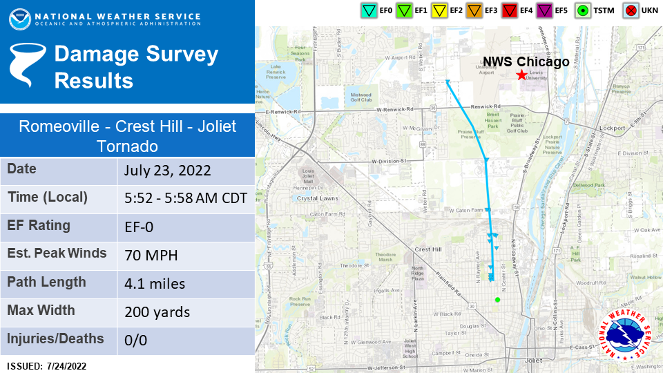
Tornado #2: Romeoville to Crest Hill to Joliet, IL EF-0 (Will County)
Summary: An NWS storm survey determined that an EF-0 tornado initially touched down along Pinnacle Dr north of Renwick Rd on the south side of Romeoville. A construction camera at Lewis University Airport indicated that the tornado likely lifted off the ground, then briefly touched down again as it moved into the Prairie Bluff Preserve in Crest Hill before lifting once more. The tornado then touched down once again near the Stateville Correctional Center, where it caused minor tree damage, and then continued tracking southward, crossing W Caton Farm Rd into a residential area of Crest Hill. A concentrated area of damage including several uprooted trees and numerous broken tree limbs was found in the vicinity of Elsie and Highland Avenues. The tornado then continued south, paralleling Highland Ave and Clement St as it crossed into the far north side of Joliet, where it produced sporadic tree limb damage before lifting at the southeast corner of Mount Moriah Cemetery just north of Ingalls Ave.
|
Tornado #3: Manhattan, IL EF-0 (Will County)
|
Summary: An NWS storm survey determined that an EF-0 tornado began just north of the intersection of Baker Rd and U.S. Route 52 and tracked southward along Route 52, causing sporadic tree damage as well as some minor roof damage to a building just south of Baker Rd on the east side of Route 52. The tornado appeared to have ended north of White Feather Dr.
|
The Enhanced Fujita (EF) Scale classifies tornadoes into the following categories:
| EF0 Weak 65-85 mph |
EF1 Moderate 86-110 mph |
EF2 Significant 111-135 mph |
EF3 Severe 136-165 mph |
EF4 Extreme 166-200 mph |
EF5 Catastrophic 200+ mph |
 |
|||||
When a tornado is known to have occurred but does not cause damage to any qualified damage indicators, or if the only damage is located in an area that is inaccessible to NWS storm survey personnel, then a tornado may be assigned the EF-Unknown (EF-U) rating.
Photos
|
|
|
 |
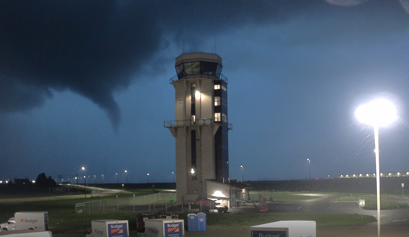
| Screenshot from a construction camera video showing a tornado south of the Lewis University Airport. Footage courtesy of the Lewis University Airport. | Storm near Gibson City, IL. Photo courtesy of Andrew Pritchard. | Multiple snapped trees at the White Eagle Golf Club in Naperville, IL. Photo courtesy of the White Eagle Golf Club. |
|
|
|
|
| Damage at the White Eagle Golf Club in Naperville, IL. Photo courtesy of the White Eagle Golf Club. | Damage at a shopping plaza at the intersection of Route 59 and 95th St. in Naperville, IL. Photo from NWS storm survey. | Damage at a shopping plaza at the intersection of Route 59 and 95th St. in Naperville, IL. Photo from NWS storm survey. |
|
|
|
|
| Damage along Clement Street in Joliet, IL. Photo courtesy of the Joliet Weather Center. | Damage along Clement Street in Joliet, IL. Photo courtesy of the Joliet Weather Center. | Damage along Clement Street in Joliet, IL. Photo courtesy of the Joliet Weather Center. |
|
|
|
 |
| Damage north of Manhattan, IL. Photo courtesy of Joel Werner. | Tree damage near Manhattan, IL. Photo courtesy of Danny Neal. | A large uprooted tree in Fairbury, IL. Photo courtesy of Bruce Sanders. |
Radar
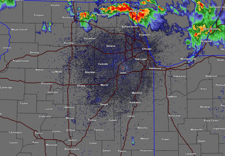 |
| Loop from our KLOT WSR-88D radar between 2 AM to 8 AM on Saturday, July 23rd. |
 |
| Loop from our KLOT WSR-88D radar between 1 PM and 4 PM depicting an afternoon round of strong to severe thunderstorms. |
Rainfall
 |
| 2-day rainfall map |
|
|
 |
| Bias-corrected rainfall estimates using data from 200 ASOS, AWOS, COOP, CoCoRaHS, USGS, and other private observations. Data is a 6-hour rainfall ending at 6 AM. | Gridded Average Recurrence Interval (ARI) values using bias-corrected rainfall estimates. A 200-year ARI, for example, indicates these rainfall totals (in a 6-hour window) have a 0.5% chance of occurring in any given year. |
PUBLIC INFORMATION STATEMENT
NATIONAL WEATHER SERVICE CHICAGO IL
1037 AM CDT MON JUL 25 2022

...PRECIPITATION TOTALS SINCE 7/22...

LOCATION                     AMOUNT    TIME/DATE       PROVIDER
----------------------------------------------------------------
LAKE BLUFF 1 W               6.68 IN   0600 AM 07/25   COCORAHS
ZION                         6.60 IN   1018 AM 07/25   CWOP
LAKE BLUFF                   6.19 IN   1013 AM 07/25   CWOP
LAKE FOREST                  5.54 IN   1015 AM 07/25   CWOP
LIBERTYVILLE                 5.34 IN   0730 AM 07/25   COCORAHS
LIBERTYVILLE 1 ESE           5.24 IN   0700 AM 07/25   COCORAHS
DEERFIELD                    5.12 IN   1015 AM 07/25   CWOP
DEERFIELD                    4.77 IN   1019 AM 07/25   CWOP
HIGHWOOD                     4.72 IN   0700 AM 07/25   COCORAHS
1 SE BOULDER HILL            4.45 IN   0600 AM 07/25   COCORAHS
LIBERTYVILLE                 4.34 IN   1013 AM 07/25   CWOP
AURORA 4 ESE                 4.34 IN   0700 AM 07/25   COCORAHS
MUNDELEIN 1 NNE              4.34 IN   0730 AM 07/25   COCORAHS
VERNON HILLS                 4.32 IN   1017 AM 07/25   CWOP
AURORA 4 ESE                 4.29 IN   0700 AM 07/25   COCORAHS
LAKE FOREST                  4.27 IN   1015 AM 07/25   CWOP
WAUKEGAN AIRPORT             4.26 IN   0955 AM 07/25   ASOS
GURNEE                       4.17 IN   1016 AM 07/25   CWOP
AURORA 4 ESE                 4.09 IN   0800 AM 07/25   COCORAHS
MOROCCO                      3.94 IN   0600 AM 07/25   COOP
ZION                         3.83 IN   1015 AM 07/25   CWOP
GURNEE 2 W                   3.77 IN   0700 AM 07/25   COCORAHS
NEW LENOX 1 SSE              3.73 IN   0700 AM 07/25   COCORAHS
4 NW REMINGTON               3.70 IN   1020 AM 07/25   AWS
NEW LENOX 1 SE               3.60 IN   0800 AM 07/25   COCORAHS
NAPERVILLE                   3.59 IN   1015 AM 07/25   CWOP
SCHAUMBURG 2 E               3.59 IN   0700 AM 07/25   COCORAHS
BOURBONNAIS                  3.57 IN   0700 AM 07/25   COOP
DEERFIELD - W. FORK N. BR. C 3.57 IN   1010 AM 07/25   HADS
KANKAKEE 1.4 WSW             3.54 IN   0600 AM 07/25   COCORAHS
NAPERVILLE 5 SSW             3.52 IN   0700 AM 07/25   COCORAHS
VOLO 0.9 S                   3.48 IN   0700 AM 07/25   COCORAHS
PORTER                       3.38 IN   0700 AM 07/25   COCORAHS
AROMA PARK 0.6 S             3.37 IN   0700 AM 07/25   COCORAHS
ST. ANNE                     3.29 IN   0700 AM 07/25   COOP
MOKENA 2 WSW                 3.27 IN   0700 AM 07/25   COCORAHS
LA GRANGE                    3.25 IN   1018 AM 07/25   CWOP
AURORA                       3.23 IN   0700 AM 07/25   COOP
HOFFMAN ESTATES              3.21 IN   0700 AM 07/25   COCORAHS
GURNEE  - DES PLAINES R.     3.20 IN   0930 AM 07/25   HADS
BANNOCKBURN                  3.20 IN   0700 AM 07/25   COCORAHS
AURORA 2 W                   3.19 IN   0700 AM 07/25   COCORAHS
MANHATTAN 5 ENE              3.15 IN   0800 AM 07/25   COCORAHS
ST. ANNE 3 NNE               3.08 IN   0700 AM 07/25   COCORAHS
MANHATTAN 1 E                3.07 IN   0730 AM 07/25   COCORAHS
RENSSELAER 5 NW              3.07 IN   0600 AM 07/25   COCORAHS
MANHATTAN 5 ENE              3.05 IN   0800 AM 07/25   COOP
CRETE 3 E                    3.03 IN   0700 AM 07/25   COCORAHS
PORTER 1 WNW                 3.03 IN   0700 AM 07/25   COCORAHS
FORESMAN - IROQUOIS R.       3.02 IN   0945 AM 07/25   HADS
1 NW ROCKDALE                3.02 IN   0700 AM 07/25   COCORAHS
HOMEWOOD                     2.99 IN   0700 AM 07/25   COCORAHS
VILLA PARK                   2.96 IN   0700 AM 07/25   COCORAHS
GLEN ELLYN 1 W               2.95 IN   0700 AM 07/25   COCORAHS
BATAVIA                      2.94 IN   0600 AM 07/25   UCOOP
NAPERVILLE 4 SE              2.94 IN   0900 AM 07/25   COCORAHS
GLEN ELLYN 1 SW              2.91 IN   0735 AM 07/25   COCORAHS
MORTON ARBORETUM             2.91 IN   0700 AM 07/25   COOP
ELK GROVE VILLAGE 2 WSW      2.90 IN   0655 AM 07/25   COCORAHS
2 SW NORTH AURORA            2.90 IN   0800 AM 07/25   COCORAHS
MOUNT AYR 2 NNE              2.88 IN   0810 AM 07/25   COCORAHS
DUPAGE R. NEAR PLAINFIELD    2.88 IN   0945 AM 07/25   HADS
MONEE 5 SE                   2.87 IN   0800 AM 07/25   COCORAHS
NAPERVILLE                   2.85 IN   0600 AM 07/25   COCORAHS
ITASCA                       2.82 IN   1025 AM 07/25   AWS
ELK GROVE VILLAGE 1 ESE      2.81 IN   0700 AM 07/25   COCORAHS
OAK FOREST 1 NNW             2.80 IN   0700 AM 07/25   COCORAHS
BEECHER 4 ENE                2.80 IN   0800 AM 07/25   COCORAHS
OSWEGO                       2.78 IN   0700 AM 07/25   COCORAHS
BATAVIA 3.4 WSW              2.78 IN   0630 AM 07/25   COCORAHS
3 WNW NORTH AURORA           2.77 IN   1020 AM 07/25   AWS
NEW LENOX 2 SW               2.76 IN   0700 AM 07/25   COCORAHS
BEECHER 3 SE                 2.76 IN   0700 AM 07/25   COCORAHS
SUGAR GROVE 1 NNW            2.75 IN   0700 AM 07/25   COCORAHS
ASHKUM 6 E                   2.74 IN   0700 AM 07/25   COCORAHS
LIBERTYVILLE                 2.74 IN   1025 AM 07/25   AWS
CARPENTERSVILLE              2.73 IN   1017 AM 07/25   CWOP
LOMBARD                      2.72 IN   0700 AM 07/25   COCORAHS
ST. JOHN 3 SSE               2.72 IN   0700 AM 07/25   COCORAHS
DEERFIELD - N. BR. CHICAGO R 2.69 IN   1010 AM 07/25   HADS
HOMER GLEN 3 S               2.69 IN   0700 AM 07/25   COCORAHS
AURORA                       2.67 IN   1015 AM 07/25   CWOP
1 ESE DEERFIELD              2.67 IN   1024 AM 07/25   AWS
4 ESE CLIFTON                2.67 IN   0600 AM 07/25   COCORAHS
BRADLEY 0.7 SW               2.66 IN   0600 AM 07/25   COCORAHS
JOLIET 0.8 E                 2.66 IN   0600 AM 07/25   COCORAHS
VILLA PARK 1 NW              2.64 IN   0600 AM 07/25   COCORAHS
ST. JOHN                     2.63 IN   0600 AM 07/25   COCORAHS
JOLIET 2 N                   2.63 IN   0700 AM 07/25   UCOOP
MOUNT PROSPECT 0.2 NNE       2.62 IN   0645 AM 07/25   COCORAHS
ALGONQUIN                    2.61 IN   1017 AM 07/25   CWOP
LOMBARD 1.2 N                2.61 IN   0800 AM 07/25   COCORAHS
SUGAR GROVE 1 NNE            2.61 IN   0700 AM 07/25   COCORAHS
RIVERWOODS 1 NE              2.61 IN   0700 AM 07/25   COCORAHS
WHEATON                      2.59 IN   1020 AM 07/25   CWOP
BLOOMINGDALE 1 SSE           2.59 IN   0700 AM 07/25   COCORAHS
WARRENVILLE                  2.58 IN   1019 AM 07/25   CWOP
WOODSTOCK                    2.58 IN   1015 AM 07/25   CWOP
CHESTERTON                   2.57 IN   1016 AM 07/25   CWOP
PALATINE 1 NNE               2.57 IN   0700 AM 07/25   COCORAHS
PALOS PARK 2 WSW             2.57 IN   0600 AM 07/25   COCORAHS
WESTMONT                     2.56 IN   1018 AM 07/25   CWOP
DUNE ACRES RAWS              2.56 IN   0955 AM 07/25   RAWS
JOLIET                       2.54 IN   1010 AM 07/25   CWOP
JOLIET 3 WNW                 2.54 IN   0700 AM 07/25   COCORAHS
SALT CR. - ELMHURST          2.52 IN   0920 AM 07/25   HADS
STREAMWOOD                   2.51 IN   1015 AM 07/25   CWOP
LOMBARD 1 NW                 2.51 IN   0800 AM 07/25   COCORAHS
BULL VALLEY 2 WNW            2.51 IN   0800 AM 07/25   COCORAHS
CLARENDON HILLS              2.51 IN   0700 AM 07/25   UCOOP
LONG LAKE                    2.50 IN   0706 AM 07/25   COCORAHS
WARRENVILLE                  2.49 IN   1019 AM 07/25   CWOP
CRETE 3 ENE                  2.49 IN   0700 AM 07/25   COCORAHS
MCHENRY 1 ENE                2.48 IN   0900 AM 07/25   COCORAHS
MUNDELEIN 4 WSW              2.48 IN   0700 AM 07/25   COOP
PLAINFIELD                   2.47 IN   1015 AM 07/25   CWOP
BARRINGTON                   2.46 IN   0800 AM 07/25   COOP
OAK LAWN                     2.46 IN   0700 AM 07/25   COCORAHS
COLLEGEVILLE                 2.45 IN   0600 AM 07/25   COCORAHS
WARRENVILLE                  2.43 IN   1015 AM 07/25   CWOP
LINDENHURST 1 NE             2.43 IN   0800 AM 07/25   COCORAHS
KANKAKEE                     2.43 IN   0700 AM 07/25   COOP
PEOTONE                      2.42 IN   0700 AM 07/25   COCORAHS
PEOTONE                      2.42 IN   0700 AM 07/25   COOP
BONFIELD                     2.41 IN   1015 AM 07/25   CWOP
HOMER GLEN 1 NNE             2.41 IN   0700 AM 07/25   COCORAHS
MIDWAY 3 SW                  2.41 IN   0700 AM 07/25   COOP
1 WSW LAKE IN THE HILLS      2.40 IN   0600 AM 07/25   COCORAHS
GENEVA 4 WSW                 2.39 IN   0600 AM 07/25   COCORAHS
BATAVIA                      2.37 IN   1015 AM 07/25   CWOP
MIDLOTHIAN                   2.37 IN   0700 AM 07/25   COCORAHS
GARY 5.9 ENE                 2.37 IN   0630 AM 07/25   COCORAHS
PARK RIDGE 1 WNW             2.36 IN   0700 AM 07/25   COCORAHS
FLOSSMOOR 1 SE               2.36 IN   0700 AM 07/25   COCORAHS
MONEE 5 W                    2.35 IN   0730 AM 07/25   COCORAHS
WOODSTOCK 4 SW               2.34 IN   0700 AM 07/25   COCORAHS
SCHERERVILLE 1 E             2.34 IN   0800 AM 07/25   COCORAHS
HAWTHORN WOODS               2.33 IN   1015 AM 07/25   CWOP
HOFFMAN ESTATES              2.32 IN   1015 AM 07/25   CWOP
PARK FOREST 1 WNW            2.31 IN   0730 AM 07/25   COCORAHS
CLIFTON 1 WNW                2.31 IN   0600 AM 07/25   COCORAHS
2 S GLEN ELLYN               2.30 IN   1025 AM 07/25   AWS
HOMER GLEN 2 NNE             2.29 IN   0700 AM 07/25   COCORAHS
JOHNSBURG                    2.28 IN   1016 AM 07/25   CWOP
WEST CHICAGO 4 SE            2.28 IN   0655 AM 07/25   COCORAHS
SCHAUMBURG AIRPORT           2.28 IN   1015 AM 07/25   AWOS
HUNTLEY                      2.27 IN   1016 AM 07/25   CWOP
EVANSTON 1 E                 2.27 IN   0800 AM 07/25   COCORAHS
MCHENRY LOCK AND DAM         2.26 IN   0800 AM 07/25   COOP
1 SW HOFFMAN ESTATES         2.26 IN   1025 AM 07/25   AWS
BATAVIA 1 NW                 2.25 IN   0700 AM 07/25   COCORAHS
BUFFALO GROVE                2.24 IN   1015 AM 07/25   CWOP
PLAINFIELD 3 ESE             2.23 IN   0900 AM 07/25   COCORAHS
PORTAGE 3 E                  2.23 IN   0700 AM 07/25   COCORAHS
BATAVIA                      2.22 IN   1001 AM 07/25   CWOP
FRANKFORT                    2.22 IN   1017 AM 07/25   CWOP
ELGIN                        2.22 IN   0700 AM 07/25   COOP
ELBURN                       2.20 IN   1020 AM 07/25   CWOP
BRIDGEVIEW 1 WNW             2.20 IN   0730 AM 07/25   COCORAHS
FOREST PARK 1 ENE            2.20 IN   0700 AM 07/25   COCORAHS
BOLINGBROOK 3 NE             2.20 IN   0700 AM 07/25   COCORAHS
1 WNW AURORA                 2.19 IN   1024 AM 07/25   AWS
OAK LAWN 2 WNW               2.19 IN   0800 AM 07/25   COCORAHS
HOMER GLEN                   2.18 IN   1015 AM 07/25   CWOP
GENEVA 1 SSW                 2.18 IN   0730 AM 07/25   COCORAHS
PARK FOREST                  2.18 IN   0500 AM 07/25   COOP
HERSCHER 3 E                 2.17 IN   0700 AM 07/25   COCORAHS
WHEATON                      2.16 IN   1020 AM 07/25   CWOP
LISLE 1 WSW                  2.16 IN   0700 AM 07/25   COCORAHS
HICKORY HILLS                2.15 IN   1016 AM 07/25   CWOP
DE MOTTE 6 S                 2.15 IN   0700 AM 07/25   COCORAHS
SOUTH HOLLAND                2.15 IN   1025 AM 07/25   AWS
PARK FOREST 1 NNE            2.14 IN   0700 AM 07/25   COCORAHS
CEDAR LAKE 2 S               2.14 IN   0800 AM 07/25   COCORAHS
HARWOOD HEIGHTS              2.13 IN   0645 AM 07/25   COCORAHS
GRIFFITH                     2.13 IN   0600 AM 07/25   COCORAHS
ARLINGTON HEIGHTS 1 W        2.12 IN   0700 AM 07/25   COCORAHS
WHEATON                      2.11 IN   1015 AM 07/25   CWOP
BOLINGBROOK 2.6 NE           2.10 IN   0800 AM 07/25   COCORAHS
GENEVA 1 SSW                 2.10 IN   0800 AM 07/25   COCORAHS
HOFFMAN ESTATES 5 W          2.09 IN   0815 AM 07/25   COCORAHS
GENEVA                       2.09 IN   0800 AM 07/25   COCORAHS
PLAINFIELD 2 SSE             2.09 IN   0700 AM 07/25   COCORAHS
BENSENVILLE                  2.08 IN   1024 AM 07/25   AWS
1 SSE CAROL STREAM           2.08 IN   1025 AM 07/25   AWS
1 WSW WOODRIDGE              2.06 IN   1020 AM 07/25   AWS
GENEVA                       2.05 IN   0700 AM 07/25   COCORAHS
ALGONQUIN 1 NNW              2.05 IN   0545 AM 07/25   COCORAHS
ELBURN                       2.04 IN   1015 AM 07/25   CWOP
BUFFALO GROVE 1 ESE          2.03 IN   0700 AM 07/25   COCORAHS
WEST CHICAGO                 2.02 IN   1015 AM 07/25   CWOP
WHEATON                      2.02 IN   1015 AM 07/25   CWOP
JOLIET                       2.02 IN   1010 AM 07/25   CWOP
BUFFALO GROVE                2.01 IN   1015 AM 07/25   CWOP
NAPERVILLE                   2.01 IN   1015 AM 07/25   CWOP
CHICAGO OHARE                2.09 IN   0951 AM 07/25   ASOS

OBSERVATIONS ARE COLLECTED FROM A VARIETY OF SOURCES WITH VARYING
EQUIPMENT AND EXPOSURES. WE THANK ALL VOLUNTEER WEATHER OBSERVERS
FOR THEIR DEDICATION. NOT ALL DATA LISTED ARE CONSIDERED OFFICIAL.
Additional Info
 |
Media use of NWS Web News Stories is encouraged! Please acknowledge the NWS as the source of any news information accessed from this site. Additional recaps can be found on the NWS Chicago Past Events Page |
|


.png)


.jpg)


