
Isolated severe thunderstorms are likely across parts of the Southeast/Deep South Tuesday morning into early evening. A couple tornadoes are possible in parts of eastern Mississippi and Alabama. In the north-central U.S., a storm will bring heavy snow and gusty to high winds over parts of the northern Plains and Upper Midwest Tuesday before impacting the Great Lakes Wednesday into Thanksgiving. Read More >
Overview
|
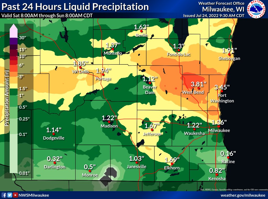
Multiple rounds of severe thunderstorm pushed through southern and central Wisconsin on Saturday evening, July 23, 2022 into early Sunday morning, July 24, 2022. This brought widespread wind damage across the area along with a few large hail reports southeast of Madison and a few funnel cloud reports in Dodge County. Additionally, these storms also brought area widespread rainfall with amounts up to and even exceeding 4 inches, especially where multiple storms moved over the same area. Saturday morning began with a round of scattered thunderstorms across the southern tier of the state. Most of these storms produced sub-severe hail, but one storm around 6 AM produced localized damaging winds around the Sturtevant and Racine area. The morning activity cleared out quickly allowing hot and humid conditions to develop across southern Wisconsin through the afternoon. This along with an approaching cold front and upper-level forcing aligning, helped set the stage for a favorable environment to fuel the multiple rounds severe thunderstorms through the evening. SPC issued two Severe Thunderstorms Watches through the event, while MKX issue numerous severe thunderstorm warnings. Additional information about the event can be found here: |
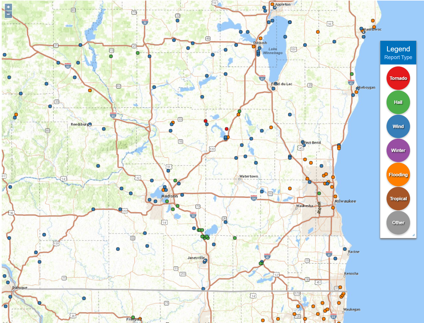 Local Storm Reports from July 23-24, 2022 |
First Round of Severe Thunderstorms:
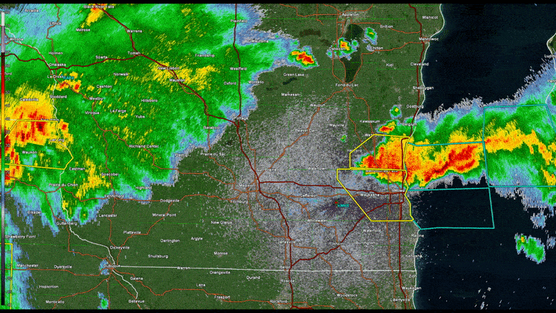
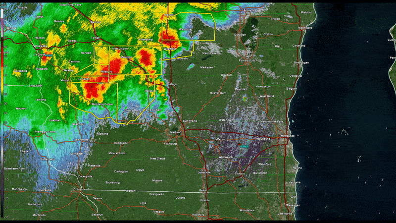 MKX - Radar loop of base reflectivity from 4:30PM - 9:00 PM CDT July 23, 2022 |
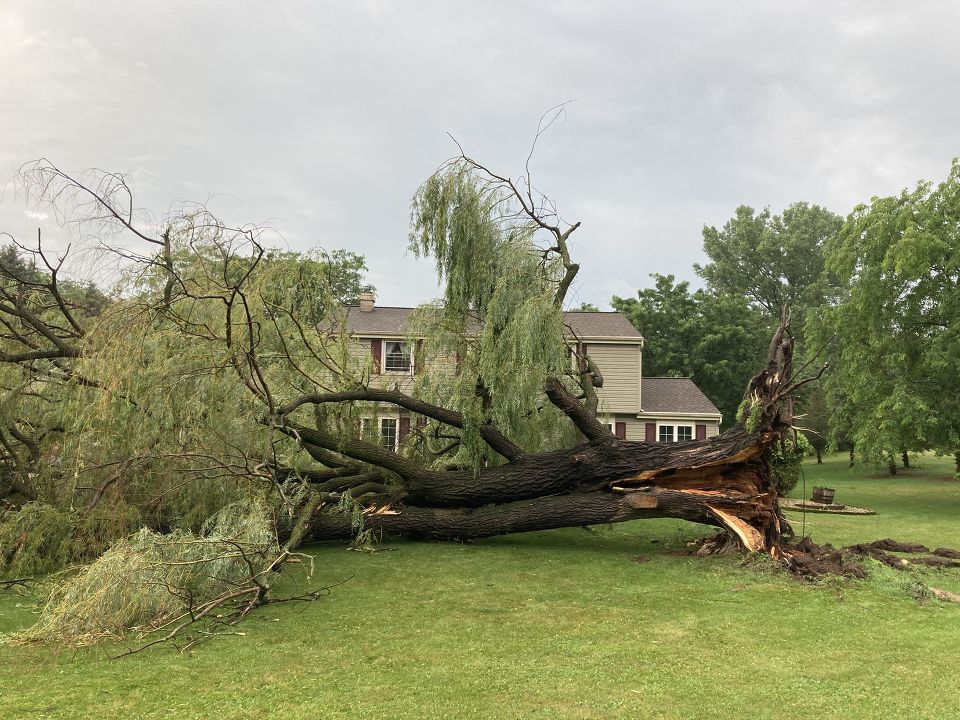
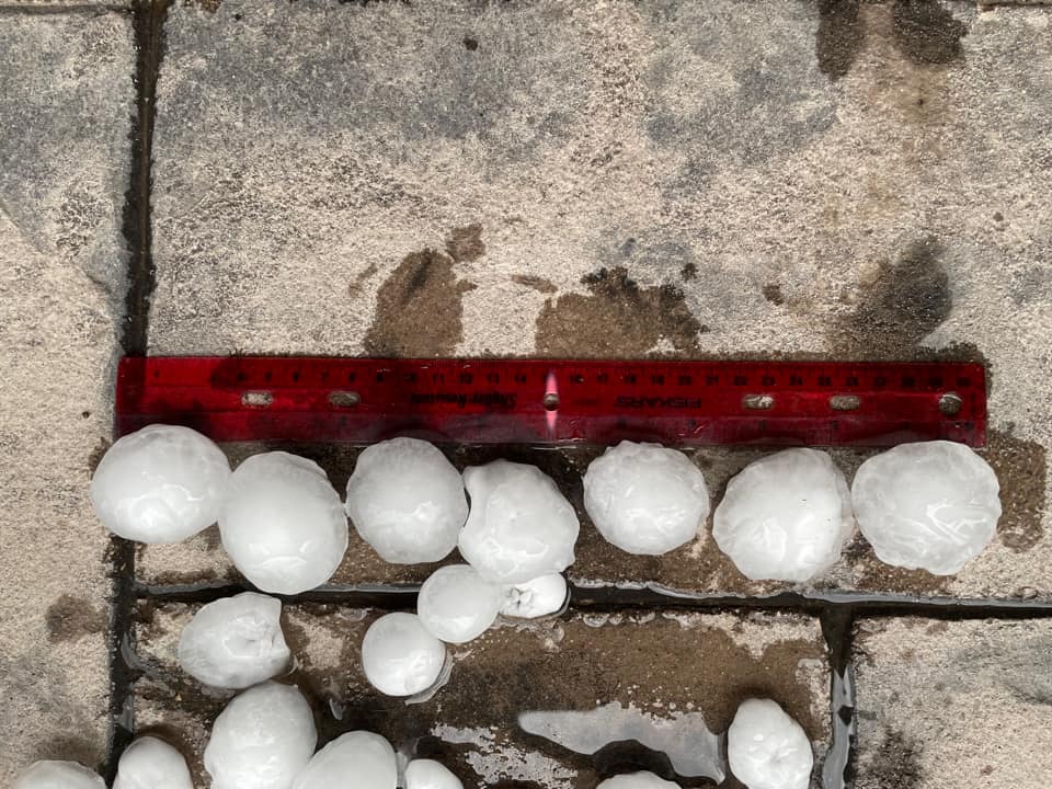
The first round of severe storms developed across central Minnesota late morning/early afternoon and tracked east-southeast into western Wisconsin. Storms began to merge into a line around 4 PM CDT and push into the area. Damaging winds were the main concern with the line, especially where any bowing features developed and numerous wind damage reports occurred. However as the line pushed further east, the western edge of the line took on more of a supercell structure across Dane County. This supercell tracked southeast across Rock County, where in addition to damaging winds also produced large hail up to 2 inches around the Lake Koshkonong area. This supercell continued into Walworth county before weakening. The first line of severe thunderstorms pushed out over Lake Michigan around 8 PM CDT. |
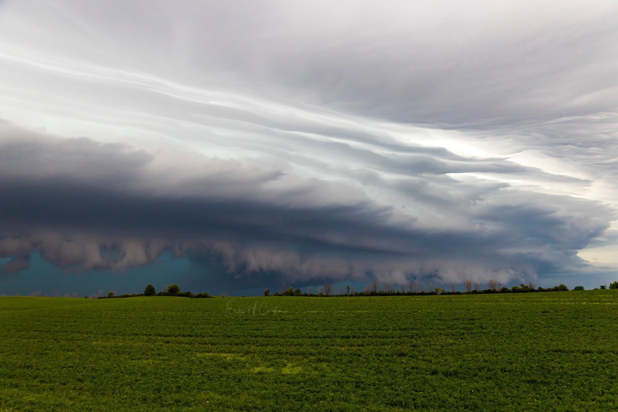
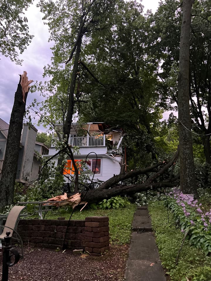
Photos & Damage from the First Round of Severe Thunderstorms
 |
 |
 |
 |
|
Shelf Cloud from Line of Severe Thunderstorms in Belgium WI Photo courtesy of Eric Curtain |
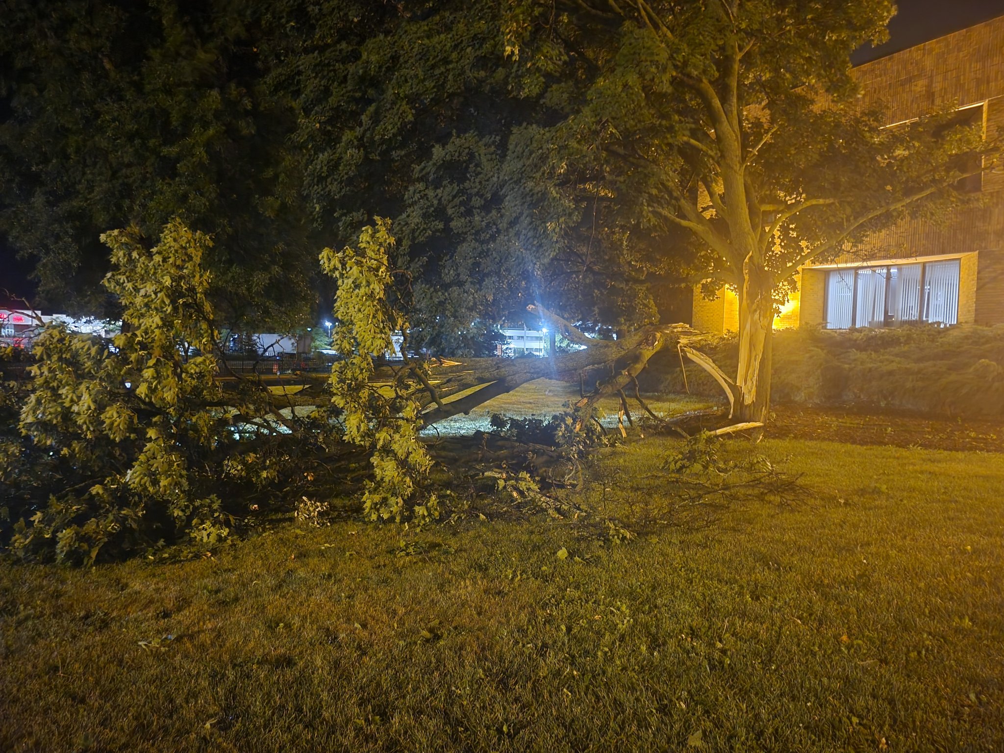
Tree Damage in West Bend, WI Photo courtesy of Jason Stendahl |
Wind Damage in Milton, WI Photo courtesy of Jennifer Markham |
Golf Ball to Egg size Hail in Edgerton, WI Photo courtesy of Marissa Hanson |
Second Round of Severe Thunderstorms:
 MKX - Radar loop of base reflectivity from 9:00 PM CDT July 23, 2022 - 12:30AM CDT July 24, 2022 |
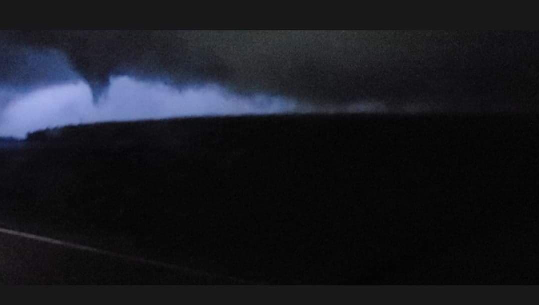
A second round of severe thunderstorms quickly developed across Marquette and Green Lake counties. This round produced another supercell, which tracked southeast across Dodge county. Rotation was evident on radar and there were multiple reports of funnel clouds associated with this storm. However, there has not been any evidence of a tornado at this time and most damage was related to straight lined winds. The supercell eventually evolved more into a linear structure and continued to produce wind damage, most notable across West Bend and Brown Deer areas before pushing out over Lake Michigan around midnight. Additionally, these storms and its heavy rain moved over a similar area as the previous round leading to flooding across Washington, Ozaukee, northeastern Waukesha, and northern Milwaukee counties counties. |
Photos & Damage from the Second Round of Severe Thunderstorms
 |
 |
 |
|
Funnel Cloud near Beaver Dam, WI Photo courtesy of Sara Wiza |
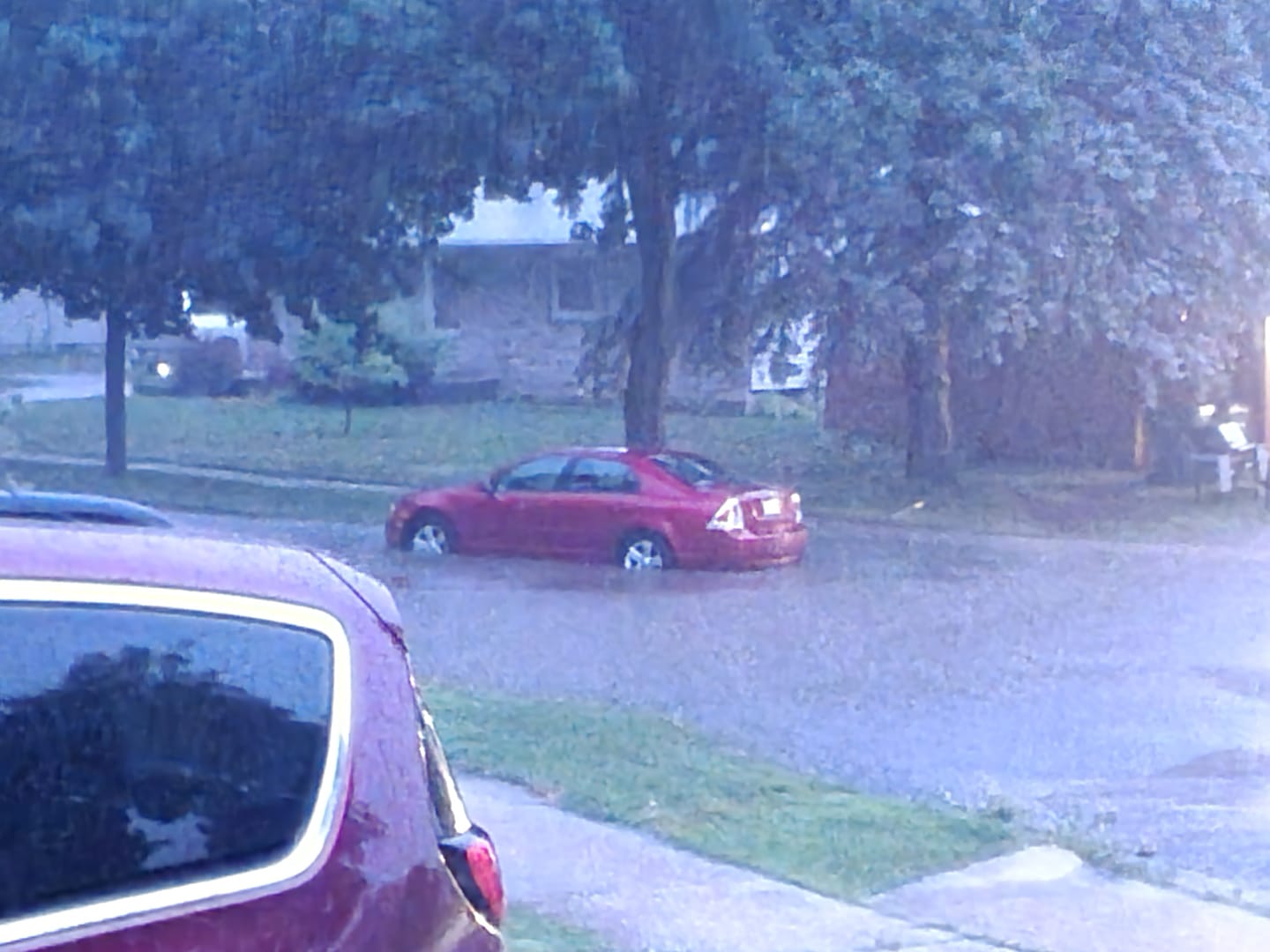
Flooding in West Bend, WI Photo courtesy of Scott Lewandowski |
Wind damage in Brown Deer, WI Photo courtesy of FOX6 - AJ Waterman |
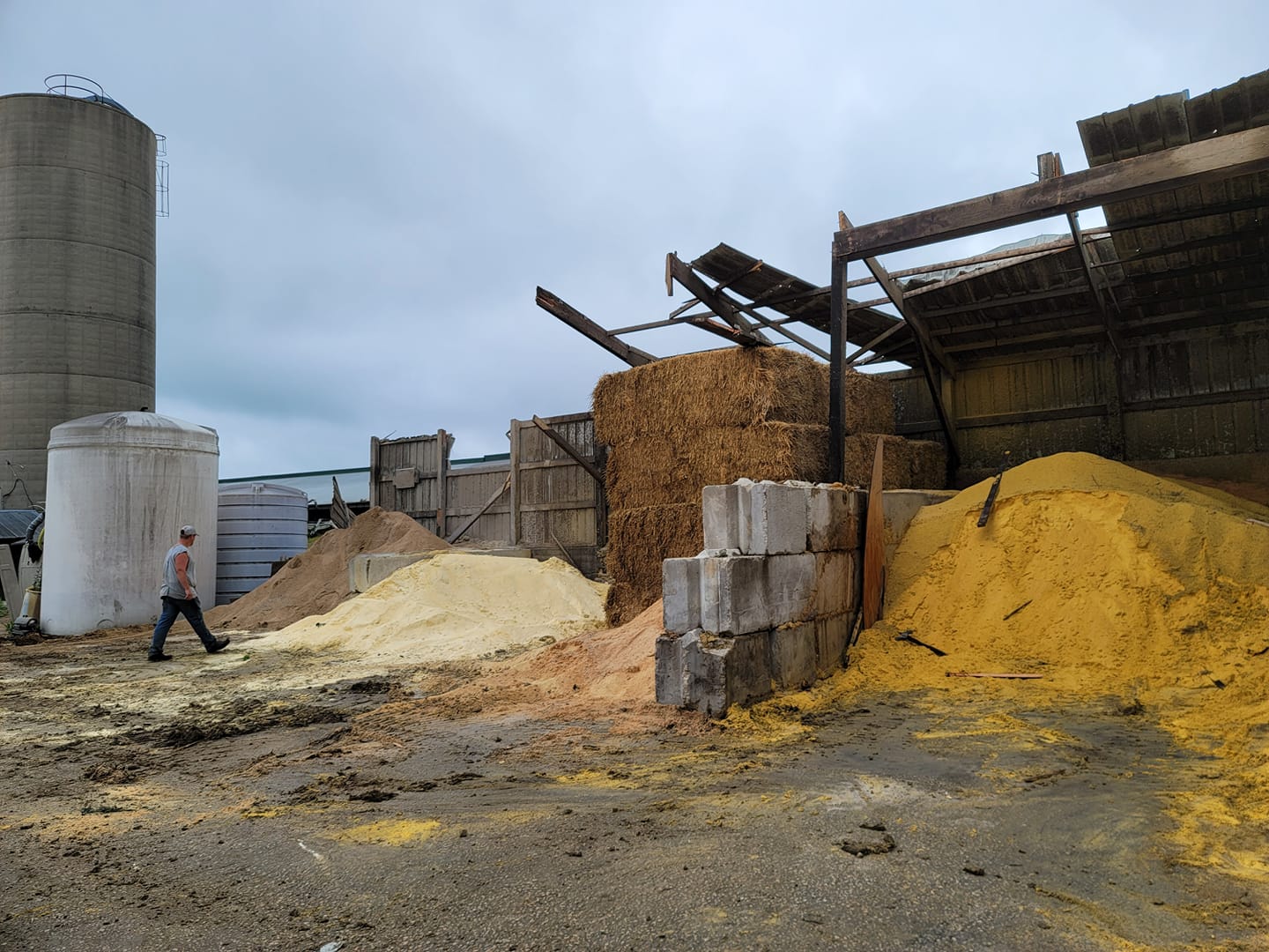
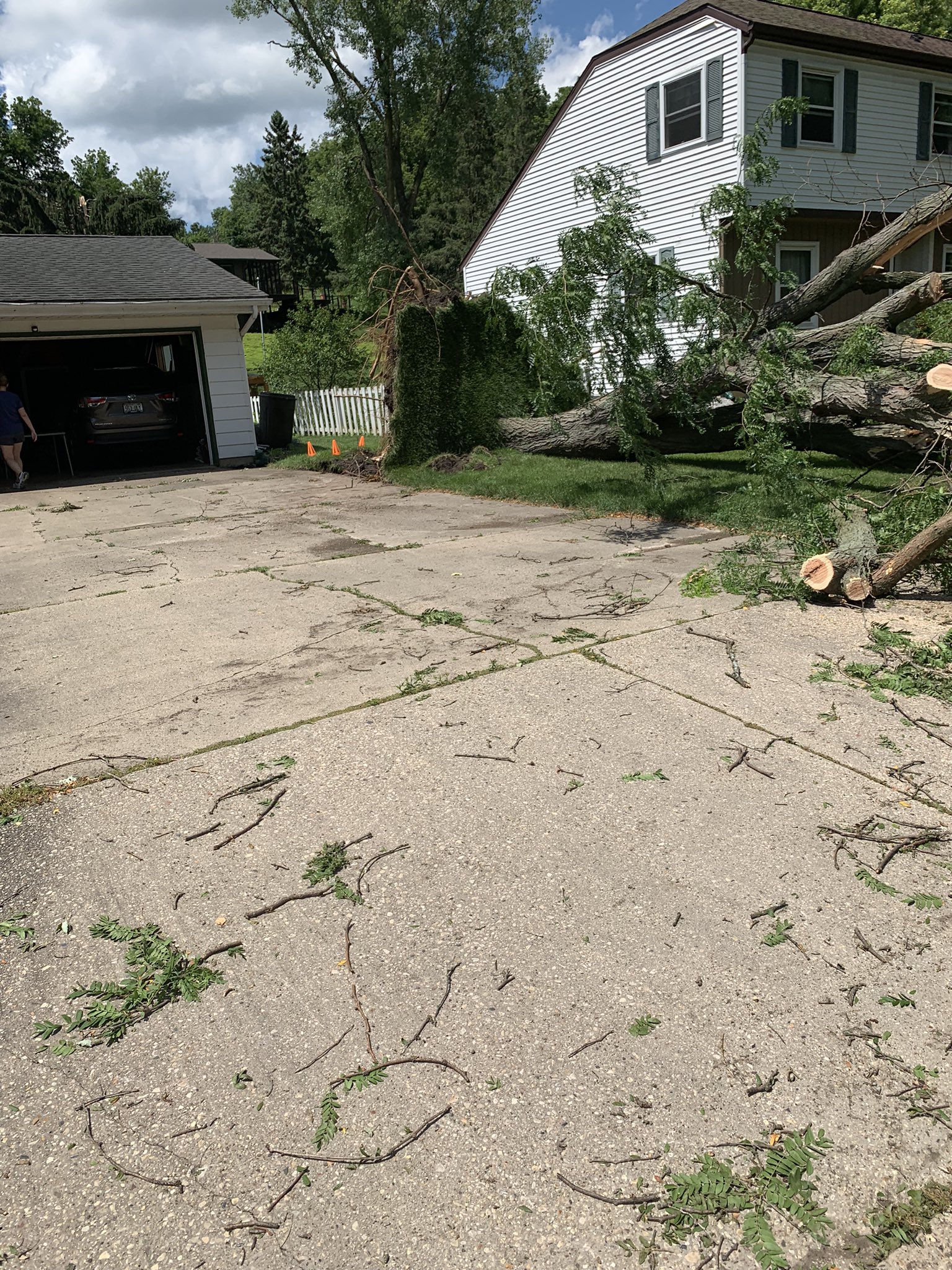
Third Round of Severe Thunderstorms:
 MKX - Radar loop of base reflectivity from 12:00 AM - 3:30 AM CDT July 24, 2022 |
Despite the previous storms, the environment remained supportive for another round of severe thunderstorms, thanks in part to a strong low-level jet developing across southern Wisconsin. This third round began to take shape across western Wisconsin and northeast Iowa. As the line pushed eastward with the northern portions taking on mesoscale convective vortex structure, the storms were able to easily mix down stronger winds aloft and multiple reports of winds in excess of 60 mph came in across southern Wisconsin. Then the line weaken as it pushed into the lake counties, but gusty winds were still occurring with the lingering shower activity. |
Photos & Damage from the Last Round of Severe Thunderstorms
 |
 |
 |
 |
|
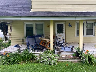
Wind Damage in Sauk City, WI Photo courtesy of Sara Beth |
Wind Damage in Linden, WI Photo courtesy of Brittany Clay |
Wind Damage in Argyle, WI Photo courtesy of Matt Maurer |
Wind Damage in Cross Plains, WI Photo courtesy of Logan Frey |
Storm Total Rainfall
Public Information Statement National Weather Service Milwaukee/Sullivan WI 605 PM CDT Sun Jul 24 2022 ...24 HR PRECIPITATION REPORTS FROM SATURDAY INTO SUNDAY OF 1.50 INCHES OR MORE... Location Amount Time/Date ...Wisconsin... ...Columbia County... Randolph 2.2 NNW 2.81 in 0800 AM 07/24 Portage 5.7 WSW 2.50 in 0600 AM 07/24 Friesland 2.40 in 0645 AM 07/24 1 NNE Pardeeville 1.81 in 0805 AM 07/24 Pardeeville 1.67 in 0214 PM 07/24 Cambria 6.9 NNW 1.65 in 0700 AM 07/24 Columbus 1.2 S 1.56 in 0700 AM 07/24 ...Dane County... Maple Bluff 1.7 N 2.02 in 0630 AM 07/24 Waunakee 0.7 WNW 1.98 in 0700 AM 07/24 Sun Prairie 1.95 in 0455 PM 07/24 Madison 4.4 NE 1.88 in 0800 AM 07/24 McFarland 1.3 NE 1.87 in 0700 AM 07/24 Madison 5.5 N 1.84 in 0800 AM 07/24 Deerfield 1.79 in 0457 PM 07/24 Cottage Grove 2.2 E 1.76 in 0700 AM 07/24 Cottage Grove 3.6 SSW 1.75 in 0700 AM 07/24 DeForest 1.74 in 0459 PM 07/24 Sun Prairie 3.0 W 1.73 in 0700 AM 07/24 Madison 3.2 ENE 1.67 in 0700 AM 07/24 ...Dodge County... Theresa 0.5 SSW 4.40 in 0700 AM 07/24 Horicon-WWTP 4.08 in 0700 AM 07/24 Theresa 0.1 ESE 4.07 in 0700 AM 07/24 Theresa 3.1 SE 3.96 in 0800 AM 07/24 Brownsville 3.67 in 0700 AM 07/24 Horicon 3.67 in 0430 PM 07/24 Horicon 2.1 ENE 3.40 in 0700 AM 07/24 Mayville 4.9 NNW 3.40 in 0723 AM 07/24 Beaver Dam 2.66 in 0500 PM 07/24 Beaver Dam 1.4 SSW 2.62 in 0658 AM 07/24 Beaver Dam 3.9 E 2.58 in 0700 AM 07/24 Juneau 2.28 in 0455 PM 07/24 Fox Lake 2.3 WNW 2.24 in 0700 AM 07/24 Beaver Dam 2.15 in 1000 AM 07/24 Beaver Dam 2.1 SW 2.03 in 0700 AM 07/24 Columbus 4.8 ENE 1.68 in 0750 AM 07/24 ...Fond du Lac County... Waupun 3.1 NNW 3.86 in 0700 AM 07/24 Campbellsport 3.85 in 0500 PM 07/24 Campbellsport 8.7 NNE 1.91 in 0700 AM 07/24 St. Peter 1.85 in 0700 AM 07/24 Mount Calvary 1.6 WSW 1.73 in 0630 AM 07/24 Fond Du Lac 1.7 E 1.60 in 0600 AM 07/24 ...Green Lake County... Markesan 4.1 NNW 2.02 in 0800 AM 07/24 ...Jefferson County... Jefferson 0.9 SW 1.95 in 0600 AM 07/24 Lake Mills 4.3 N 1.85 in 0700 AM 07/24 Johnson Creek 3.2 NW 1.76 in 0700 AM 07/24 Waterloo 1.68 in 0800 AM 07/24 Jefferson-WWTP 1.65 in 0700 AM 07/24 Fort Atkinson 0.3 SSE 1.63 in 0700 AM 07/24 Waterloo 1.63 in 0732 AM 07/24 Lac LaBelle 1.2 SW 1.55 in 0747 AM 07/24 ...Marquette County... 2.0 SE Montello 1.52 in 0700 AM 07/24 ...Milwaukee County... Brown Deer 0.8 NW 3.42 in 0700 AM 07/24 Fox Point 0.5 SSW 2.85 in 0700 AM 07/24 Milwaukee 3.6 NNW 2.13 in 0600 AM 07/24 1 W Shorewood 2.06 in 0500 AM 07/24 ...Ozaukee County... Port Washington 4.2 NE 3.86 in 0700 AM 07/24 Cedarburg 3.78 in 0457 PM 07/24 Mequon 3.50 in 0414 AM 07/24 1 SW Mequon 3.25 in 0715 AM 07/24 1 NNE Port Washington 3.15 in 0700 AM 07/24 Cedar Grove 2.1 SSW 2.91 in 0720 AM 07/24 West Bend 7.3 E 2.71 in 0700 AM 07/24 Saukville 2.62 in 0630 AM 07/24 Port Washington-CoCoRaHS 2.53 in 0700 AM 07/24 Cedarburg 1.2 SSW 2.39 in 0700 AM 07/24 Mequon 2.7 ENE 1.95 in 0700 AM 07/24 ...Sauk County... 4 SSE Lime Ridge 3.14 in 0645 AM 07/24 Rock Springs 1.6 NW 3.06 in 0700 AM 07/24 Rock Springs 2.8 WSW 2.90 in 0700 AM 07/24 Reedsburg 1.3 N 2.71 in 0650 AM 07/24 Baraboo 2.46 in 0445 PM 07/24 Baraboo 6.0 NNE 2.10 in 0700 AM 07/24 Baraboo 3.2 ESE 1.95 in 0800 AM 07/24 ...Sheboygan County... Random Lake-CoCoRaHS 2.97 in 0700 AM 07/24 Cedar Grove 0.4 NNE 2.59 in 1000 AM 07/24 Belgium 3.8 NW 2.36 in 0625 AM 07/24 Sheboygan 0.7 SSW 1.99 in 0745 AM 07/24 Plymouth 1.91 in 0500 PM 07/24 Sheboygan Falls 0.9 ENE 1.78 in 0700 AM 07/24 Sheboygan 3.7 NW 1.56 in 0800 AM 07/24 ...Walworth County... Whitewater 4.7 SSE 2.04 in 0700 AM 07/24 Elkhorn 0.4 ESE 1.69 in 0530 AM 07/24 Elkhorn 5.3 N 1.53 in 0700 AM 07/24 ...Washington County... Jackson 1.9 N 5.35 in 0910 AM 07/24 Kewaskum 1.8 WNW 4.24 in 0700 AM 07/24 West Bend 3.9 N 3.99 in 0600 AM 07/24 Allenton 1.4 WSW 3.93 in 0548 AM 07/24 West Bend 3.81 in 0745 AM 07/24 Jackson 0.5 SSE 3.78 in 0715 AM 07/24 West Bend 1.3 NNW 3.75 in 0551 AM 07/24 West Bend 5.4 SE 3.72 in 0800 AM 07/24 Slinger 1 WNW 3.52 in 0700 AM 07/24 West Bend 3.4 WSW 3.48 in 0700 AM 07/24 Hubertus 3.1 E 3.00 in 0600 AM 07/24 Richfield 2.8 WNW 2.83 in 0800 AM 07/24 Germantown 0.6 S 2.47 in 0700 AM 07/24 0.7 SW Hartford 2.46 in 0900 AM 07/24 1.9 SE Hubertus 2.32 in 0600 AM 07/24 Hartford 1.7 ESE 2.11 in 0700 AM 07/24 ...Waukesha County... Menomonee Falls 3.2 NNW 2.54 in 0700 AM 07/24 Genesee Depot 2.45 in 0306 PM 07/24 Menomonee Falls 2.0 NE 2.40 in 0700 AM 07/24 Menomonee Falls 1.9 NNE 2.12 in 0555 AM 07/24 Oconomowoc 1.2 W 1.64 in 0700 AM 07/24 New Berlin 0.6 ESE 1.50 in 0700 AM 07/24 Observations are collected from a variety of sources with varying equipment and exposures. We thank all volunteer weather observers for their dedication. Not all data listed are considered official. |
 |
 |
Media use of NWS Web News Stories is encouraged! Please acknowledge the NWS as the source of any news information accessed from this site. |
|

