BASIC ICE CLOUD MICROPHYSICS
Ice Crystal Formation
Three processes can cause ice crystal formation in a cloud, including heterogeneous nucleation, deposition, and ice multiplication.
Heterogeneous Nucleation:
Heterogeneous nucleation is the process by which ice crystals form from liquid water molecules as the molecules collect and freeze onto foreign particles, such as dust, clay, and aerosols.
Heterogeneous nucleation is most likely at temperatures less than -10 C (especially around -15 C), but can occur as warm as -5 C; heterogeneous nucleation accelerates the freezing of drops, i.e., if no foreign particles are present, the air must be much colder for freezing to occur.
However, ice embryos also can pre-exist in clouds, which can freeze drops at temperatures warmer (around -5 C) than those associated with heterogeneous nucleation freezing. If freezing occurs by this process, larger drop diameters tend to have higher/warmer freezing temperatures (e.g., a 1.0 mm drop freezes at about -12 C) than smaller drops (e.g., a 0.2 mm drop freezes at about -20 C), since large drops have more freezing nuclei/particles in them.
Deposition:
Deposition is the process by which ice crystals form directly from the water vapor stage in a saturated, subfreezing cloud, although deposition nuclei (centers upon which ice crystals form) must be present.
The number of crystals forming in a cloud via deposition is a function of temperature. At temperatures greater than -10 C, not enough deposition nuclei are present to form enough crystals for an efficient precipitation process to occur, although crystals can still form. Temperatures colder than -10 C, i.e., -10 to -20 C, are necessary for efficient crystal formation via the deposition process.
The deposition process is maximized at temperatures of -12 to -15 C when coincident with saturated ascent. At these temperatures, ice crystals grow at the expense of water droplets, as water vapor molecules migrate to the crystals. Also, these temperatures typically are found in the 700 to 500 mb layer in winter, i.e., where ascent usually is maximized near the level of non-divergence in winter storms. This can be visualized in time-height cross sections of vertical motion, temperature, and relative humidity.
Deposition can produce cloud size crystals around 1 mm but this generally is not large enough to produce much surface precipitation (see crystal growth information below).
Ice Multiplication:
Ice multiplication results in many more crystals in a cloud than that caused by heterogeneous nucleation or deposition alone. Ice multiplication results in fragmented or splintered ice crystals; ice (rime) splintering occurs at temperatures warmer than -10 C while mechanical fracture of ice occurs at colder than -10 C.
Ice (rime) splintering is the primary ice multiplication mechanism and is common at temperatures from 0 to -10 C with a peak at about -5 C. Splintering occurs when crystals originating in saturated layers aloft that are colder than -10 C (from either heterogeneous nucleation or deposition) fall into a 0 to -10 C layer where many supercooled droplets exist. The droplets freeze as they contact the crystals, then tend to break up (fragment/splinter) if large enough as the crystal/frozen droplet particles travel through the cloud.
Ice multiplication via splintering is common where low and middle-level saturated ascent is occurring with mean temperatures about -5 C (e.g., in a comma head of a mature cyclone or where strong isentropic ascent and frontogenetical forcing are occurring). In these areas, a lot of crystals and nuclei are present due to ice multiplication which, due to strong ascent, rise into layers with temperatures less than -10 C. This in turn leads to additional crystal formation and deposition which can then result in even more ice multiplication and so on. The result is that bursts of heavy snow can occur.
Ice Crystal Growth
Ice Crystal Types:
Ice crystals come in different types and shapes which are dependent on the temperatures in which they form and grow. The shapes of crystals and their associated temperature range include:
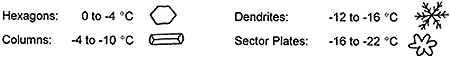
Dendritic crystals are the dominant type in many snow events as they form in a range of temperatures that is most conducive to deposition and maximum ascent in the 700 to 500 mb layer.
Ice crystal formation and growth by deposition alone typically cannot produce much precipitation sized particles. Ice crystal growth to precipitation sized particles (about 10 mm) is achieved via riming and aggregation. Growth rate increases as the size of ice particles increases.
Riming:
Growth by riming occurs and is most efficient when crystals fall from a cold layer aloft (less than -10 C) and contact supercooled water droplets in a saturated 0 to -10 C layer below, causing freezing of the droplets. Many of these particles then break apart via ice multiplication and splintering resulting in many different sized crystals. Excessive riming can produce snow graupel and sleet.
Aggregation:
Aggregation is a very important method for crystal growth, and occurs when the terminal fall speeds of varying crystal shapes are different resulting in crystal collisions and subsequent growth.
Fall speeds generally are strongly dependent on the shapes and sizes of crystals, which is a function of the temperatures in which they are growing (which affects shape) and the amount of riming (which affects size) crystals have undergone. For dendrites, fall speed is independent of crystal diameter; for columns and graupel, fall speed is dependent on diameter.
|
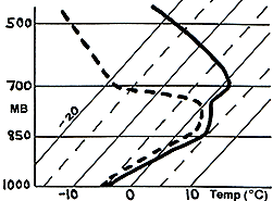
Soundings which are saturated through a deep layer (i.e., saturation spans a wide range of temperatures) will feature different crystal shapes which increases the efficiency of the aggregation process and the growth of the crystals (e.g., as shown in Figure 1). Aggregation also increases when crystals become sticky, i.e., when temperatures are above -10 C (below about 700 mb). Soundings that have deep isothermal layers at or below 0 C (below 700 mb) coincident with saturated ascent can produce very large crystals and snowflakes due to lots of aggregation. Figure 1 shows a saturated isothermal layer from about 950-850 mb. |
 |
In Summary:
In assessing heavy snow potential, first evaluate whether strong lift and enough cold air are present in the lower and middle levels of the atmosphere. Next, check soundings for deep saturated layers and whether a low-to-middle level isothermal layer is present below 0 C. Finally, determine if the maximum ascent is coincident with the -12 to -16 C temperature range (which enhances dendritic crystal formation and growth). These features can be evaluated via observed and model soundings as well as time-height cross sections. These factors can combine to produce heavy snow with large snowflakes.
PRECIPITATION CONCEPTS; FACTORS AFFECTING PRECIPITATION; THICKNESS
Precipitation Concepts
Freezing Rain:
|
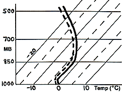
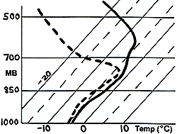
Precipitation starts in cold air aloft as ice crystals/snowflakes that have formed via heterogeneous nucleation, deposition, and ice multiplication and grown through aggregation and riming. Crystals then fall through a melting (warm) layer that is sufficiently deep or warm enough to completely melt the crystals to water drops. The drops then become supercooled as they fall through a subfreezing (refreezing) layer near the surface and freeze on contact if ground objects are colder than 0 C (32 F). A typical freezing rain sounding is shown in Figure 2. Melting layers greater than 1200 ft deep usually cause complete melting, although for large flakes or for maximum melting layer temperatures less than or equal to 1 C, a deeper melting layer may be required for complete melting. |
 Figure 2 Figure 2 |
If the ground temperature is warmer than 0 C but the air temperature is colder than 0 C, then heat conduction may prevent freezing on the ground/streets, but freezing will occur on elevated cold surfaces, i.e., trees, power lines, and cars. If the ground is frozen, then freezing rain can occur despite air temperatures above 0 C (at least for awhile).
Freezing Drizzle:
Most freezing drizzle soundings are similar to freezing rain soundings except that drizzle soundings usually are accompanied only by weak ascent and a dry layer near and above 700 mb on top of a low-level moist layer (Figure 3). This results in only small precipitation particles at the surface.
However, some freezing drizzle events occur with complete subfreezing temperatures in the sounding (surface and above) where there is a low-level moist layer between about 0 and -5 C and deep dry air aloft near and above 700 mb (Figure 4). This results from the supercooled warm rain process, i.e., droplets in the moist layer remain supercooled due to a lack of ice embryos, ice crystals, and nuclei to freeze on at these temperatures (remember that heterogeneous nucleation and deposition are most common at temperatures equal to and colder than -10 C).
|
|
|
Sleet:
|
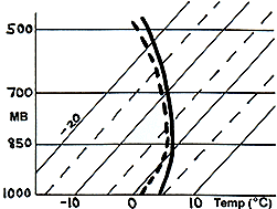
A sleet sounding is similar to that for freezing rain, i.e., a melting layer aloft and subfreezing layer below are present. The main differences are the depth and temperature of these two layers and the crystal/snowflake size as to whether complete (freezing rain) or partial (sleet) melting occurs. A typical sleet sounding is shown in Figure 5. Partially melted snowflakes can refreeze much more readily resulting in sleet (or even snow) than completely melted crystals, since ice nuclei still exist in partially melted particles. As the melting layer decreases in depth and temperature and the subfreezing layer increases in depth, the probability of sleet or a mix of sleet and snow graupel increases. |
|
Unmixed (no freezing rain) sleet events usually are most probable when the average minimum temperature of the low-level subfreezing layer is colder than -5 C. Mixed (sleet and freezing rain) events can occur when the minimum temperature of the subfreezing layer is as warm as -2.5 C.
Snow Versus Rain:
A borderline rain/snow sounding (Figure 6) is different (opposite) from freezing rain and sleet soundings in that the melting/warm layer usually exists near the surface while subfreezing temperatures are located aloft above the warmer boundary layer air.
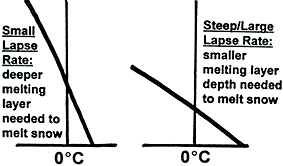
The depth of low-level warm air (below the freezing level) needed to melt snow falling from above to rain varies from about 750-1500 ft and depends on the mass of the flakes and the lapse rate of the melting layer. When the lapse rate is small (i.e., temperature decreases slowly with height in the layer; left diagram in Figure 7), the melting layer is weak so it must be deeper to melt snow completely. When the lapse rate is large (right diagram in Figure 7), the layer can be smaller and still melt snow.
 |
 |
Precipitation likely will be snow at the surface if the height/depth of the melting layer is less than 900 ft (i.e., a 50 percent or greater chance of snow reaching the ground). If the depth is only about 200 ft (i.e., surface temperatures are above freezing but the freezing level is at 200 ft above the ground), then the probability of snow is about 90 percent. If the depth is more than 1000 ft, then the probability of snow decreases rapidly below 50 percent.
It is crucial to evaluate the depth and temperature of warm and cold layers (as well as which layer lies on top versus underneath) in soundings to help determine precipitation type in the winter.
Factors Affecting Precipitation
Thermal Advection:
Local change of temperature (at a point) = (Temperature advection) + (Upward vertical motion) + (Diabatic processes).
The local temperature change especially is important aloft where precipitation is forming in borderline precipitation type areas, i.e., transition zones.
If warm air advection (WAA) is occurring (typical phenomenon ahead of storm systems), then upward vertical motion (UVM), which causes adiabatic cooling, usually also is occurring (i.e., isentropic lift). However, warm air advection often overwhelms the cooling produced by upward vertical motion resulting in a net warming at a particular point aloft (e.g., as occurs ahead of an approaching warm front).
If ascent and adiabatic cooling are quite significant (other physical processes must be occurring in the atmosphere), the warm advection may be overwhelmed resulting in little or no net temperature change or even cooling aloft (e.g., which can result in what appears to be a nearly stationary warm front since the air ahead of the front is not warming due to strong lift). When model data show little or no warming (e.g., in 850/700 mb temperatures or thickness values) in the face of warm advection, then strong lift must be present which could result in significant precipitation.
If warm air advection is occurring with not that much lift, then net warming will be most efficient and isentropes will move in the same direction as the wind. In general, actual warming at a point aloft is about one-half that expected from warm advection alone, due to compensating upward motion.
Diabatic Effects:
In major storms, thermal advection and vertical motion usually are the controlling factors in determining precipitation type. However, in weaker storms where advection is relatively weak, or near precipitation type transition zones, diabatic effects, such as melting, evaporative cooling, and solar radiation, can be important.
Evaporative Cooling: Evaporation removes heat from the air resulting in a temperature decease. If an unsaturated layer is present on a sounding and precipitation is expected to fall through it from above, then use the wet bulb temperature, which is between the temperature and dewpoint, to determine the effect evaporative cooling will have on the ultimate temperature of the layer and precipitation type. In borderline situations, evaporative cooling could cause precipitation to fall as or change to snow for awhile before possibly changing to rain if warmer air moves in after layer saturation. Depending on the temperature and dewpoint spread and precipitation rate, evaporative cooling could cause the temperature to fall several degrees until saturation occurs.
Melting: Melting of snow requires heat from the air, causing a net cooling. Normally, local temperature aloft is affected much more by thermal advection than by melting, with the effect of melting fairly insignificant. In fact, evaporation often causes more cooling than does melting. However, if advection is weak, the sounding is marginal between freezing rain, sleet, and snow, and if the precipitation rate is significant, then enough melting of snow to rain aloft could o0


 Weather Story
 Weather Map
 Local Radar