
June 1830
Counties: Clark IN and Jefferson KY
F-scale:
Deaths:
Injuries:
Path width: 70 yards
Path length:
Time:
Narrative: Moved east, crossing the Ohio River about 6 miles "north" (upstream?) of Louisville, knocking down trees and fences.
August 27, 1854
Counties: Jefferson KY
F-scale: F2
Deaths: 25
Injuries: 100
Path width: 800 yards
Path length: 2 miles
Time: 12:12pm
Notes: This deadly storm touched down near the intersection of Jefferson and Twentieth Streets, unroofing 21 buildings at the German Protestant Orphan Asylum. The Louisville Daily Courier described the storm as "a whirlwind revolving leftwise." The tornado appears to have travelled in an east-southeasterly direction. Seventeen houses were damaged along Walnut Street from Fifteenth to Seventeenth Streets, a home was severely damaged near the corner of Madison and Thirteenth Streets, and a factory was damaged at the corner of Chestnut and Twelfth Streets. However, the most catastrophic damage occurred when the tornado destroyed the Third Presbyterian Church at Walnut and Eleventh Streets. At a quarter past noon during Sunday services the twister struck the church, causing it to collapse. A door was opened by gusts of wind just moments prior to the tornado, and this may have been one factor in the destruction of the church as powerful tornado winds battered the outside of the building and also were allowed to sweep into the interior of the building. Many women and children were killed, the youngest victim being nine years old. A mother and her three children were discovered grouped in death, and in another spot a father lay dead with the mother mortally wounded, their young child placed beneath them unhurt, protected by the forms of its parents. The toll in the church was about 18 to 20 dead, out of the 55 who were in the church at the time. From the Daily Courier, describing the aftermath of the destroyed church, "Each piercing shriek reveals the fact that some new dead form has been brought to light. Here comes a father borne along by his friends, who take him from his bed of death; next the mother, then the daughter and two sons -- all crushed -- mutilated -- dead!" The church was scheduled to be dedicated the following Sunday. A Mr. Joseph Bradley, while assisting in removing victims from the rubble immediately after the storm, had his eye cut out by a hatchet wielded by a nearby person removing fallen rafters. Mr. Bradley made a full recovery. It was noted in subsequent days that the church was very poorly constructed. People would cross the street rather than walk by it. The Daily Courier noted, "There was scarcely any more cohesiveness in the mortar in the brickwork than if had been made of sand and water." Older, shabbier buildings in the storm were less damaged than the church full of parishioners. Moving on from the church, the tornado tore off rooftops along Tenth, Ninth, and Eighth Streets between Chestnut Street and Broadway. A new frame home was destroyed on Sixth Street just south of Broadway, and chimney and other miscellaneous damage occurred along Broadway between Fifth and Fourth Streets as the tornado began to dissipate. The final damage was that of an unroofed house at the corner of Breckenridge and Fifth Streets. It was the worst disaster seen in Louisville up to that time. At least a hundred buildings were affected. Mayor James Speed ordered all businesses in the city closed the next day.
Side note: Interestingly, in researching this event, we found two distinct paths of destruction across Louisville (see map). The path described above was more certainly a tornado. The other path was parallel to the tornado and about half a mile to the north, on the west edge of downtown. Significant destruction was done on Main Street between Ninth and Eighth Streets where two of the "best and most substantial business houses in the city were scattered as though they had been made of cards," with the walls collapsing inward. A factory was damaged on Main Street just west of Ninth Street, in the Tobacco District. Boats in the Ohio River were blown loose of their moorings and landed on the falls. Many boats were damaged and some were totally destroyed, including a steamboat. Four houses were even blown down across the river in Jeffersonville. Significant damage continued until the intersection of Main and Sixth Streets. Beyond that, slight damage was done to the Walnut Street Baptist Church (corner of Fourth Street and Muhammad Ali Boulevard), and worshippers participating in Mass at the cathedral on Fifth Street were blown off their feet. It has been decided, to the best of our ability, that these events were due to straight-line winds. Also, the storm brought extremely heavy rain that caused Beargrass Creek to flood, but the rains were generally welcome as the region had been suffering through a severe drought.
June 2, 1875
Counties: Jefferson KY
F-scale: F2
Deaths: 0
Injuries: 2 (known)
Path width: 880 yards
Path length: 3 miles
Time: 7:00pm local time
Notes: This storm swept through the southern half of Louisville with the primary damage swath a mile wide. However the actual tornado appears to have been about half a mile wide, embedded within the wind damage. The tornado moved from west to east, generally bounded by Kentucky Street on the north and Oak Street on the south. The first damage from the tornado took place along Eighteenth Street (today's Dixie Highway). Large brick homes lost their roofs on 18th at Prentice and at Oak. Proceeding to the east, some of the most concentrated damage was done along Harney and Churchill Streets (both now Saint Catherine) from Sixteenth Street to Tenth Street. A stable was destroyed and a frame home "was knocked higher than a kite" on Harney between Fifteenth and Sixteenth (just east of today's California Park). A frame cottage was entirely destroyed and a three-story brick residence lost its facade along Churchill between Fifteenth and Fourteenth. Homes were unroofed on both the east and west sides of the intersection of Churchill at Thirteenth. Cottages were destroyed on the southeast corner of Churchill and Twelfth. A brick house on Twelfth between Churchill and Oldham was blown down. Cottages were destroyed at Churchill and Eleventh and a brick house was blown down just south of that intersection. In the block bordered by Kentucky, Oak, Eleventh, and Tenth (along Oldham Street) the Louisville Bridge Company building was wrecked, with only the northern part of it (which was on the northern fringe of the tornado) still standing. The rest of the building was leveled to the ground. Homes lost their roofs along Oak Street at Sixth, between Fifth and Fourth, and at Fourth. Houses were damaged at Churchill and Fourth, and the Baptist Orphan's Home lost its roof at Churchill and First. The tornado may have then turned to the left (northeast) as it caused F2-level damage to a two-story brick dwelling near the corner of Breckinridge and Preston. It dissipated shortly thereafter. Significant wind damage occurred outside the tornado's path. Strong winds, possibly a result of a phenomenon known as a "rear flank downdraft" or RFD, blew down the length of Magnolia Street from Twelfth to Third. Saints Mary and Elizabeth Hospital lost part of its roof at Twelfth, roofs were lost at Sixth, and homes were damaged at Fourth and Third. As the tornado turned to the northeast, so did the RFD, and a two-and-a-half story house lost its roof in Germantown (which the 1875 newspaper described as a "remote suburb") at Mary and Logan Streets. The final damages northeast of the tornado's endpoint were at Chestnut and Madison where a horse-and-buggy were turned over and at Main and Jackson (site of today's Slugger Field) where a tree was blown down. However, some of the most significant damage of the storm took place almost a mile south of where this project feels the true tornado took place. The Masonic Home for Widows and Orphans was located where DuPont Manual High School is today. The facility was shaped somewhat like a squat capital "H," with the relatively longer sides of the H lined up along B Street and C Street (now Bloom Street and Cardinal Boulevard), and the short connecting section parallel to First and Second Streets (the two longer sides of the "H" had been stand-alone buildings, and were subsequently connected by the short middle section of the "H"). When the storm came through, the entire middle section of the building was obliterated. It's interesting to note that the part that was destroyed was aligned north-south, so that a strong west wind, which would be typical of an RFD, would have hit it broadside. Or, it's also possible that a small satellite vortex spun out of the main tornado to the north. Fortunately the section that was demolished was so new that it hadn't even been moved in to yet. However, two boys at the home were hurt. Click here for an incredible picture of the damage (courtesy of the University of Louisville Photographic Archives).
June 8, 1899
Counties: Orange
F-scale: F2
Deaths:
Injuries:
Path width:
Path length:
Time:
Narrative: Timber and barns were destroyed four miles north of Paoli.
June 25, 1902
Counties: Garrard, Madison
F-scale: F2
Deaths: 4
Injuries: 25
Path width:
Path length: 9 miles
Time: 10:00pm
Narrative: Moved northeast from near Cartersville to north of Berea. An elderly man and a child were killed in a home two miles west of Berea. Two other people died in Garrard County near Cartersville. At least 15 homes were destroyed or torn apart.
June 1, 1917
Counties: Fayette
F-scale: F2
Deaths: 0
Injuries: 3
Path width:
Path length:
Time: 10:30am
Narrative: Buildings were unroofed in downtown Lexington and at Sayre College.
June 6, 1917
Counties: Butler (from Muhlenberg)
F-scale: F2
Deaths: 7
Injuries: 30
Path width: 75 yards
Path length: 17 miles
Time: 5:00pm
Narrative: Moved east from two miles north of Greenville to near Powderly and to southeast of Rochester. The tornado moved through a rural area of poorly constructed homes, many owned by miners. A number of these homes were swept away. One man was killed in Butler County, running from a house to a barn. Both were destroyed.
July 29, 1943
Counties: Clark, IN
F-scale: F3
Deaths: 0
Injuries: 25
Path width: 300 yards
Path length: 7 miles
Time: 7:00pm
Narrative: After damaging a farm one mile west of Charlestown, the tornado moved into the village. The twister first struck Pleasant Ridge on the southwest side of town, which was a neighborhood of pre-fab housing built for war effort employees. Sixty-five homes were unroofed, shifted, or blown apart, and seven people were badly hurt. The tornado sounded like "a dozen freight trains crossing a trestle." It then proceeded through the center of Charlestown and removed several roofs. The tornado was about three blocks wide in Charlestown. Debris could be seen in the air swirling around the funnel.
June 7, 1948
Counties: Clark, IN
F-scale: F4
Deaths: 1
Injuries: 20
Path width: 100 yards
Path length: 7 miles
Time: 6:10pm
Narrative: Moved southeast along the edge of Henryville. A child was killed as a two-story hilltop home was leveled and swept away. About twenty other homes were damaged.
August 1, 1954
Counties: Orange
F-scale: F2
Deaths:
Injuries:
Path width:
Path length:
Time: Noon
Noted discrepancies: SPC and NCDC list this as an F2, Grazulis does not list it. SPC gives a path length of 1/10 of a mile, NCDC gives nothing. SPC gives a path width of 10 yards, NCDC gives nothing.
August 2, 1954
Counties: Washington KY
F-scale: F2
Deaths: 0
Injuries: 0
Path width:
Path length:
Time: 3:00pm
Grazulis Narrative: Three barns and a small school were destroyed two miles south of Springfield. One home was unroofed.
Noted discrepancies: SPC and Storm Data list both Taylor and Washington counties...NCDC lists only Taylor County...Grazulis lists only Washington County. SPC's and Storm Data's "Taylor and Washington" counties makes no sense since those two counties don't border each other. SPC/NCDC's lat/lon pairs start this tornado in Taylor County and end it in Washington County, crossing the entire width of Marion County in between. SPC and NCDC give a path length of 15 miles, Grazulis and Storm Data give 1 1/2 miles. SPC gives a path width of 10 yards...NCDC 30 yards...Grazulis and Storm Data 100 yards. Apparently the only tornado damage Grazulis could find with this event was two miles south of Springfield near the Washington/Marion County line (which is where SPC and NCDC have the tornado track's end point). Storm Data narrative says, "Tornado first appeared near Finley in Taylor County, completely missed Marion County, and came to earth again in Washington County a short distance south of Springfield." The distance across Marion County is about 14 miles. Thus, it seems this should be plotted as two separate tornadoes...with one in Taylor County near Finely and the other in Washington County near Springfield. However, before plotting the Taylor County tornado, an F-scale must be investigated.
July 13, 1956
Counties: Fayette, Bourbon
F-scale: F1
Deaths: 0
Injuries: 0
Path width: 30 yards
Path length: 3 miles
Time: 5:00pm
Grazulis Narrative: Moved northeast from extreme northeast Fayette County, tearing apart four farms. At least one barn was destroyed.
Noted discrepancies: SPC and NCDC list this as an F1...Grazulis calls it an F2. SPC and NCDC give a time of 6:00pm, Storm Data gives 5:00pm, Grazulis says 6:30pm. SPC gives a path length of 1/10 of a mile...NCDC gives nothing...Grazulis gives 3 miles. SPC and Grazulis give a path width of 30 yards...NCDC gives nothing...Storm Data says 38 yards. SPC and NCDC give only a touchdown point (which agrees with Grazulis' touchdown point), but no lift-off point.
June 9, 1961
Counties: Adair
F-scale: F2
Deaths:
Injuries:
Path width:
Path length:
Time: 1:00pm
Noted discrepancies: SPC and NCDC rank this as an F2, Grazulis does not list it. SPC gives a path width of 10 yards, NCDC says 30 yards.
July 23, 1961
Counties: Clark IN
F-scale: F2
Deaths: 0
Injuries: 0
Path width:
Path length:
Time: 6:30pm
Grazulis narrative: Near New Washington a small tornado leveled two barns and damaged a farm house.
Noted discrepancies: SPC gives a path length of 1/10 of a mile and a width of 10 yards...NCDC gives nothing for either.
July 23, 1961
Counties: Clark IN
F-scale: F1
Deaths:
Injuries:
Path width:
Path length:
Time: 6:30pm
Noted discrepancies: SPC gives a path length of 1/10 of a mile and a width of 10 yards...NCDC gives nothing for either.
June 8, 1963
Counties: Taylor
F-scale: F1
Deaths:
Injuries:
Path width: 20 yards
Path length: 1/3 of a mile
Time: 1:00pm
Noted discrepancies: SPC gives a path width of 10 yards and a path length of 1/10 of a mile...NCDC gives nothing for either. Storm Data gives a path length of 500 yards and a width of 20 yards.
Notes: Storm Data says this tornado hit Palestine.
June 12, 1964
Counties: Scott KY
F-scale: F1
Deaths:
Injuries: 2
Path width:
Path length:
Time: 3:30pm
Noted discrepancies: None.
June 15, 1964
Counties: Scott KY, Harrison KY, Nicholas (and Fleming)
F-scale: F2
Deaths: 0
Injuries: 0
Path width: 30 yards
Path length: 49 miles
Time: 2:30pm
Grazulis narrative: Moved east, destroying barns and badly damaging two farm houses near Turkey Foot. This was one of a family of small tornado that skipped across three counties.
Noted discrepancies: At NCDC Scott County is listed twice and Harrison and Nicholas counties are not included. Storm Data only mentions Scott, Harrison, and Fleming counties (which doesn't make sense since Nicholas County is between Harrison and Fleming counties). The end lat/lon in the first NCDC Scott County entry is the same as the begin lat/lon in the second Scott County entry. Grazulis lists only Scott County...he does not specifically list Harrison or Nicholas...though he does mention that his Scott County tornado was "one of a family of small tornadoes that skipped across three counties" and he does mention Fleming County as being one of those three. SPC gives an ending lat/lon of 38.42/-83.73...NCDC gives 38.40/-83.93. SPC and NCDC give a path length of 49 miles, Grazulis gives one mile, Storm Data says 50 miles. SPC gives a path width of 10 yards, NCDC 30 yards, Grazulis gives nothing. Storm Data says the tornado touched down near Skinnersburg in Scott County, then lifted and touched down again at Turkey Foot in Scott County..."apparently across Harrison County", and then did damage near Flemingsburg. Should probably plot as one coherent tornado from Skinnersburg to Fleming, including all counties in between (and avoiding Bourbon County).
June 15, 1964
Counties: Adair
F-scale: F2
Deaths:
Injuries:
Path width:
Path length:
Time: 4:30pm
Noted discrepancies: SPC and NCDC list this as an F2...Grazulis does not list it.
August 13, 1966
Counties: Ohio
F-scale: F2
Deaths:
Injuries:
Path width:
Path length:
Time: 5:25pm
Noted discrepancies: SPC/NCDC call this an F2...Grazulis does not list it.
Notes: Storm Data says this tornado touched down one and a half miles northeast of Hartford and moved northeast for a mile and a half.
August 9, 1968
Counties: Scott IN
F-scale: F2
Deaths: 0
Injuries: 0
Path width:
Path length:
Time: 2:00pm
Grazulis narrative: A barn was destroyed near Scottsburg. Minimal F2.
Noted discrepancies: SPC gives a path length of 1/10 of a mile and a width of 10 yards...NCDC gives nothing for either.
June 13, 1970
Counties: Hancock
F-scale: F1
Deaths:
Injuries:
Path width:
Path length:
Time: 6:45am
Notes: According to Storm Data, one house was struck on Happy Hollow Road four miles south of Hawesville.
July 18, 1971
Counties: Henry, Shelby
F-scale: F2
Deaths:
Injuries:
Path width:
Path length:
Time: 2:15pm
Grazulis narrative: In the Pleasureville-Defoe area a tornado destroyed three barns and a silo.
Noted discrepancies: NCDC and Grazulis only list Henry County. The single lat/lon SPC gives is indeed in Shelby County, but very close to the county line. SPC gives a path length of 1/10 of a mile and a path width of 10 yards...NCDC and Grazulis give nothing for either. Both places of damage listed by Grazulis are on the Henry/Shelby county line. Using damage locations listed by Grazulis the path length might have been longer than the 1/10 mile given by SPC. Storm Data says the tornado touched down between Pleasureville and Defoe and almost immediately lifted back into the clouds. Storm Data lists both Shelby and Henry counties.
July 2, 1972
Counties: Simpson
F-scale: F1
Deaths:
Injuries:
Path width:
Path length:
Time: 6:30pm
Noted discrepancies: None
July 28, 1972
Counties: Hart
F-scale: F1
Deaths:
Injuries:
Path width:
Path length:
Time: 6:30pm
Notes: According to Storm Data, this tornado damaged four city blocks on the west side of Munfordville.
August 19, 1972
Counties: Madison
F-scale: F2
Deaths:
Injuries: 1
Path width:
Path length:
Time: 2:00pm
Noted discrepancies: NWS lists this as an F2, Grazulis does not list it. SPC gives a path length of 1/10 of a mile and a path width of 10 yards...NCDC gives nothing for either.
August 25, 1972
Counties: Nelson
F-scale: F1
Deaths:
Injuries:
Path width:
Path length:
Time: 1:50pm
Noted discrepancies: SPC gives a path width of 10 yards, NCDC gives 30 yards. This tornado is not listed in Storm Data! More research would be helpful.
June 16, 1973
Counties: Clark IN
F-scale: F1
Deaths:
Injuries:
Path width:
Path length:
Time: 7:10pm
Noted discrepancies: Lat/lon actually places this in Oldham County. Listed in Storm Data in Clark County near New Washington. More research is needed.
June 20, 1973
Counties: Warren
F-scale: F1
Deaths:
Injuries:
Path width:
Path length:
Time: 8:00pm
Noted discrepancies: SPC gives a path width of 10 yards, NCDC 30 yards. The SPC and NCDC longitude (-88.45) for this tornado is in Marshall County. If changed to -86.45 it is in Warren County (right in Bowling Green). Storm Data reports damage on a farm just south of Bowling Green. Even if using -86.45, that would put the tornado right in the city of Bowling Green, not on a farm south of town. More research reveals that this very small tornado hit the Kenneth Hardcastle property between Hardcastle and Greenhill east-southeast of Bowling Green.
June 27, 1973
Counties: Clark IN
F-scale: F1
Deaths:
Injuries:
Path width:
Path length:
Time: 9:00am
Notes: Six homes damaged in Utica. Tornado was described as "small, yellow, and muddy looking."
June 27, 1973
Counties: Lincoln
F-scale: F1
Deaths:
Injuries:
Path width:
Path length:
Time: 1:00pm
Noted discrepancies: SPC gives a path width of 10 yards, NCDC 30 yards.
June 27, 1973
Counties: Shelby
F-scale: F1
Deaths:
Injuries:
Path width:
Path length:
Time: 1:00pm
Noted discrepancies: SPC gives a path width of 10 yards, NCDC 30 yards. The lat/lon given at SPC and NCDC for this tornado is in Nicholas County. Storm Data lists it in Shelby County. If the longitude is changed from SPC/NCDC's -84.08 to -85.08, it's in Shelby County. More research would be nice.
June 27, 1973
Counties: Hart
F-scale: F1
Deaths:
Injuries: 2
Path width:
Path length: 4 miles
Time: 3:30pm
Noted discrepancies: SPC gives a path width of 10 yards, NCDC gives 30 yards.
Narrative: Tornado touched down about a mile southwest of Canmer and moved to the east-northeast. In the Canmer area, Gilead Church (near the intersection of US 31E and Gilead Fairview Road) lost its roof, and debris from the roof was found two miles away. A house under construction collapsed and injured the man inside, while another man was pulled from the garage and rolled across the ground. Several homes lost roofs. Hopewell Cumberland Presbyterian Church was damaged. Near the end of the track along Davis Bend Road, trees were blown down and 22 barns and stables were damaged or destroyed. Marble sized hail was also reported.
July 22, 1973
Counties: Simpson
F-scale: F1
Deaths:
Injuries:
Path width:
Path length:
Time: 3:00pm
Noted discrepancies: SPC gives a path width of 10 yards, NCDC gives 30 yards.
June 22, 1974
Counties: Oldham
F-scale: F1
Deaths:
Injuries:
Path width:
Path length:
Time: 6:20pm
Noted discrepancies: None
June 30, 1977
Counties: Jefferson KY
F-scale: F0
Deaths:
Injuries:
Path width:
Path length:
Time: 6:30pm
Notes: Storm Data says this tornado struck Valley Station.
June 30, 1977
Counties: Anderson
F-scale: F1
Deaths: 0
Injuries: 0
Path width: 300 yards
Path length: 1 mile
Time: 8:00pm
Grazulis narrative: Moved east-southeast in the south part of the county. A trailer and two barns were destroyed. A house was damaged.
Noted discrepancies: SPC and NCDC list this as an F1, Grazulis ranks it as an F2. SPC and NCDC place it at 8:00pm, Grazulis and Storm Data at 10:00pm.
June 29, 1979
Counties: Shelby
F-scale: F1
Deaths:
Injuries:
Path width:
Path length:
Time: 5:35pm
Notes: Storm Data has this tornado touch down at Finchville and end near Bagdad.
June 29, 1979
Counties: Franklin, Scott KY, Harrison KY
F-scale: F2
Deaths:
Injuries: 7
Path width:
Path length:
Time: 6:00pm
Noted discrepancies: SPC and NCDC list this as an F2, Grazulis does not list it. NCDC's county-by-county lat/lons result in a very strange path. Will use more logical SPC lat/lons for plotting. Storm Data has this tornado touch down four miles north of Frankfort and moves it to Georgetown and near Cynthiana. Further research would be good, to confirm this tornado's track.
July 12, 1979
Counties: Scott KY
F-scale: F1
Deaths:
Injuries:
Path width:
Path length:
Time: 2:30pm
Notes: Storm Data touches this tornado down on "Lemon Hill Road" near Georgetown...it seems this should be "Lemons Mill Road".
August 1, 1979
Counties: Jefferson IN
F-scale: F0
Deaths:
Injuries:
Path width:
Path length:
Time: 10:25am
Notes: Storm Data has this tornado touch down near Paris.
June 7, 1980
Counties: Orange
F-scale: F1
Deaths: 0
Injuries: 0
Path width:
Path length:
Time: 6:00pm
Notes: This tornado touched down in or near Paoli.
June 7, 1980
Counties: Orange
F-scale: F1
Deaths:
Injuries:
Path width:
Path length:
Time: 6:00pm
Noted discrepancies: This tornado blew down a barn on the north side of Orleans.
The Louisville Courier-Journal mentions two tornadoes in Washington County on this day. One in the Livonia, Smedley, and Salem areas, and the other in the Fredericksburg/Martinsburg area. This project has been unable to find any corroboration of this at Storm Data, NCDC, SPC, or Grazulis (though, in the interest of full disclosure, the entry for Indiana in this month's Storm Data simply says, "No Data Received"). Also, the tornado in the Fredericksburg/Martinsburg area may be the tornado listed next, which is officially placed just across the border in far northern Harrison County. The only specific damage mentioned by the Courier-Journal from either of these potential tornadoes is a mobile home losing its roof at Smedley. At this time will not plot any tornadoes in Washington County.
June 7, 1980
Counties: Harrison IN
F-scale: F1
Deaths:
Injuries:
Path width:
Path length:
Time: 6:30pm
Noted discrepancies: None
June 10, 1980
Counties: Fayette
F-scale: F0
Deaths: 0
Injuries: 0
Path width: 30 yards
Path length: 3 miles (skipping)
Time: 4:00pm
Notes: This tornado touched down in Lexington on Patterson Street and skipped to the east-southeast at 35mph, lifting near New Circle Road south of Winchester Road. Numerous trees and power lines were blown down and windows were broken.
July 2, 1980
Counties: Scott KY, Fayette
F-scale: F1
Deaths: 0
Injuries: 0
Path width: 300 yards
Path length: 13 miles (skipping)
Time: 6:55pm
Noted discrepancies: SPC gives a path width of 10 yards, NCDC 30 yards, Storm Data 300 yards. The details concerning this tornado are somewhat murky, but it appears that it touched down southwest of Georgetown where it damaged a greenhouse, and skipped to the east into far northern Fayette County. The Lexington Leader mentions the tornado north of the city but doesn't say anything about any damage. Rather, the paper instead describes damage in Lexington in a southwest-northeast path from Collier Court through Balmoral Court to the intersection of Bryanwood Parkway and Bellcastle Road. It's possible that this was a very small weak tornado, but knowing that for certain is virtually impossible this far after the event. The newspaper also mentions light damage on Nantucket Drive and Melbourne Way in the southwest part of the city, and a tree that was blown down somewhere on Emerson Drive.
July 2, 1980
Counties: Mercer, Woodford
F-scale: F1
Deaths:
Injuries: 1
Path width:
Path length:
Time: 7:30pm
Noted discrepancies: Storm Data also includes Jessamine County, but mentions no specific damage.
July 2, 1980
Counties: Boyle
F-scale: F1
Deaths:
Injuries:
Path width:
Path length:
Time: 7:45pm
Noted discrepancies: Storm Data mentions damage at Perryville, Parksville, and Michelsville. Lat/lon pair given by SPC disagrees with this storm striking Perryville. Cannot find Michelsville on any map. There is a Mitchellsburg in Boyle County, but it's not in line with Perryville/Parksville. Will plot according to the lat/lon for now.
August 5, 1981
Counties: Taylor
F-scale: F2
Deaths:
Injuries: 1
Path width:
Path length:
Time: 9:00pm
Noted discrepancies: NWS ranks this as an F2, Grazulis does not list it.
June 16, 1982
Counties: Clark KY
F-scale: F2
Deaths: 0
Injuries: 4
Path width: 30 yards
Path length: 12 miles
Time: 11:00am
Grazulis narrative: A nursing home, gas station, and trailers were wrecked near Winchester.
Noted discrepancies: None
August 11, 1983
Counties: Warren
F-scale: F1
Deaths:
Injuries: 6
Path width:
Path length:
Time: 2:00pm
Notes: Storm Data says this tornado struck the Greenwood Trailer Park on the north side of Bowling Green.
August 11, 1983
Counties: Clark KY
F-scale: F0
Deaths:
Injuries:
Path width:
Path length:
Time: 2:50pm
Noted discrepancies: Storm Data says this storm struck on Irvine Road. Mapped as best as possible, since lat/lon given was just off of Irvine Road. In appears to have struck in or very near Winchester, so additional research may help to pinpoint its exact location.
August 12, 1983
Counties: Garrard
F-scale: F0
Deaths:
Injuries:
Path width:
Path length:
Time: 8:00pm
Notes: Storm Data says this tornado struck on Gaffney Road. Plotted on Gaffney Road as close to the given lat/lon as possible.
June 23, 1984
Counties: Trimble
F-scale: F1
Deaths:
Injuries: 1
Path width:
Path length:
Time: 8:15pm
Noted discrepancies: None
July 26, 1984
Counties: Spencer
F-scale: F2
Deaths: 0
Injuries: 0
Path width: 70 yards
Path length: 2 1/2 miles
Time: 4:00pm
Grazulis narrative: Several barns were destroyed or unroofed near Taylorsville. Trees three feet in diameter were twisted off eight feet above the ground.
Noted discrepancies: None
July 26, 1984
Counties: Warren
F-scale: F1
Deaths:
Injuries:
Path width:
Path length:
Time: 4:00pm
Notes: Storm data places this tornado just south of Smiths Grove.
June 7, 1985
Counties: Lincoln
F-scale: F0
Deaths:
Injuries:
Path width:
Path length:
Time: 10:39am
Noted discrepancies: None
June 10, 1985
Counties: Shelby
F-scale: F0
Deaths:
Injuries:
Path width:
Path length:
Time: Midnight
Notes: Storm Data begins this tornado on the west side of Simpsonville.
June 11, 1985
Counties: LaRue
F-scale: F0
Deaths:
Injuries:
Path width:
Path length:
Time: 5:00pm
Noted discrepancies: None
July 11, 1986
Counties: Hardin
F-scale: F1
Deaths:
Injuries: 1
Path width:
Path length:
Time: 9:00pm
Noted discrepancies: Storm Data mentions damage on Black Jack Road in southeast Radcliff.
June 2, 1987
Counties: Anderson
F-scale: F0
Deaths:
Injuries:
Path width:
Path length:
Time: 3:55pm
Noted discrepancies: None
June 13, 1987
Counties: Meade
F-scale: F1
Deaths:
Injuries:
Path width:
Path length:
Time: 5:30pm
Noted discrepancies: None
June 16, 1987
Counties: Hancock
F-scale: F0
Deaths:
Injuries:
Path width:
Path length:
Time: 6:15pm
Notes: Storm Data mentions damage at Pellsville and Roseville.
July 5, 1987
Counties: Harrison IN
F-scale: F0
Deaths:
Injuries:
Path width:
Path length:
Time: 4:30pm
Noted discrepancies: None
July 5, 1987
Counties: Orange
F-scale: F0
Deaths:
Injuries:
Path width:
Path length:
Time: 4:30pm
Noted discrepancies: None
July 13, 1987
Counties: Woodford
F-scale: F0
Deaths:
Injuries:
Path width:
Path length:
Time: 1:30pm
Notes: Storm Data says this tornado hit the Buckley Wildlife Refuge.
August 9, 1987
Counties: Clinton
F-scale: F0
Deaths:
Injuries:
Path width:
Path length:
Time: 7:23pm
Notes: Storm Data says this tornado touched down just south of Shipley.
July 18, 1988
Counties: Meade
F-scale: F1
Deaths:
Injuries:
Path width:
Path length:
Time: 1:05pm
Noted discrepancies: None
June 12, 1989
Counties: Shelby
F-scale: F1
Deaths:
Injuries:
Path width:
Path length:
Time: 1:17pm
Noted discrepancies: None
June 2, 1990
Counties: Orange (from Martin, to Lawrence)
F-scale: F4
Deaths:
Injuries:
Path width:
Path length:
Time: 6:29pm
Grazulis narrative: Grazulis gives a lengthy description of this tornado, but does not give any information about Orange County, most likely since the tornado just barely clipped the corner of the county and went through an extremely rural, wooded area that is virtually unpopulated.
Noted discrepancies: Only Martin, Orange, and Lawrence are listed in this SPC entry. Grazulis has an event that starts in Illinois at 5:20pm and crosses into Indiana as a 110-mile long tornado family path. Grazulis lists Hamilton, Wayne, Edwards, Wabash IL, Knox, Gibson, Pike, Daviess, Martin, Orange, and Lawrence IN (note the last three match the SPC entry). NCDC lists Hamilton County Illinois with an F4 at 5:20pm, agreeing perfectly with Grazulis. Along Grazulis' path at NCDC, Wayne County Illinois is listed as an F4 at 5:24pm, Edwards County Illinois as an F4 at 5:49pm, Wabash County Illinois as an F4 at 6:08pm, Knox County Indiana as an F4 at 6:29pm, Gibson County Indiana as an F4 at 6:39pm, Pike County Indiana as an F4 at 6:48pm, Daviess County Indiana as an F4 at 7:08pm, Martin County Indiana as an F4 at 7:24pm, Orange County Indiana as an F4 at 7:41pm, and Lawrence County Indiana as an F4 at 7:43pm. Strange time disagreement between SPC and NCDC.
Notes: Grazulis/NCDC seem more believable here. Grazulis/NCDC information agrees well with a track map of the outbreak drawn up by NSSFC. Storm Data says this tornado entered Orange County three miles south-southwest of Huron and entered Lawrence County three miles south-southeast of Huron. Will plot in Orange County according to the Storm Data description. Further research would be nice, to see what it did in Orange County, though it went through a rather desolate area in Hoosier National Forest.
June 2, 1990
Counties: Orange
F-scale: F1
Deaths:
Injuries:
Path width:
Path length:
Time: 7:54pm
Notes: Storm Data says this tornado struck Orangeville and Orleans.
June 2, 1990
Counties: Washington IN
F-scale: F0
Deaths:
Injuries:
Path width:
Path length:
Time: 8:17pm
Noted discrepancies: None
June 2, 1990
Counties: Washington IN, (Jackson), Scott IN, Jefferson IN
F-scale: F3
Deaths: 0
Injuries: 0
Path width: 150 yards
Path length:
Time: 8:25pm
Grazulis narrative: Moved east-northeast through rural areas from one mile south of Milport passing two miles east of Crothersville and two miles southeast of Paris Crossing, ending one mile northeast of Lancaster. One home was destroyed and 15 were damaged.
Noted discrepancies: SPC has a path length of 41 miles, NCDC has 31 miles, Grazulis says 29 miles. Using NCDC's lat/lons this comes out rather strange. May need to re-visit this with SPC's lat/lons.
June 2, 1990
Counties: Washington IN
F-scale: F2
Deaths: 0
Injuries: 2
Path width: 150 yards
Path length: 5 miles
Time: 9:03pm
Grazulis narrative: Moved east from 1 1/2 miles southeast of Salem, passing south of Harristown, and ending one mile northwest of South Boston. Seven trailers and a barn were destroyed, 15 trailers and several frame homes were damaged.
Noted discrepancies: Grazulis lists this at 10:03pm.
June 2, 1990
Counties: Crawford, Harrison IN
F-scale: F2
Deaths: 0
Injuries: 9
Path width:
Path length: 11 miles
Time: 9:30pm
Grazulis narrative: Moved east-northeast from near I-64 at Riddle to five miles east-northeast of Carefree. Four homes were destroyed and several others damaged two miles north of Carefree, injuring several people. Three 400-foot-long broiler buildings were destroyed at Magnolia. The path ended at Blue River.
Noted discrepancies: SPC and Grazulis list a path width of 100 yards, NCDC lists 200 yards. Grazulis lists this tornado at 10:30pm.
June 2, 1990
Counties: Clark IN, Jefferson IN, Trimble
F-scale: F3
Deaths: 0
Injuries: 5
Path width:
Path length: 17 miles
Time: 9:40pm
Grazulis narrative: Moved east from near Marysville, with the funnel up to a half mile wide, just north and northeast of New Washington. The most intense damage was 200 yards wide. Many buildings, homes, and trailers were severely damaged. In Kentucky 15 homes and 25 barns were damaged in and around Mount Pleasant, with one injury. The funnel lifted northeast of Bedford.
Noted discrepancies: SPC and NCDC list a path width of 440 yards, Grazulis lists 400 yards. Ending lat/lon at SPC is over the Ohio River. NCDC does not include Trimble County. Grazulis takes it to just northeast of Bedford, which generally agree with a track map of the outbreak drawn up by NSSFC. Storm Data mentions that the tornado entered Jefferson County three miles east-northeast of New Washington and then crossed into Trimble County ending northeast of Bedford and mentions damage at Mount Pleasant as well. Will use the end point given by Storm Data and Grazulis. Grazulis times this tornado at 10:40pm.
June 2, 1990
Counties: Floyd, Clark IN
F-scale: F3
Deaths: 0
Injuries: 7
Path width: 300 yards
Path length: 12 miles
Time: 9:57pm
Grazulis narrative: Moved east-northeast from one mile northwest of Galena to Sellersburg, passing through Floyds Knobs and Hamburg. Over 25 homes and mobile homes were destroyed. A bowling alley and several businesses were damaged at Sellersburg.
Noted discrepancies: SPC gives an endpoint longitude of -85.75, NCDC gives -85.78. SPC more closely agrees with Grazulis. Grazulis lists this tornado at 10:57pm.
June 2, 1990
Counties: Oldham, Henry
F-scale: F3
Deaths: 0
Injuries: 5
Path width: 75 yards
Path length: 10 miles
Time: 10:30pm
Grazulis narrative: Moved east from just east of Goshen, passing one mile north of Lagrange, and through Jericho. At the edge of Lagrange three frame homes and three mobile homes were destroyed. A dozen other homes were damaged.
Noted discrepancies: SPC and NCDC give a path length of 10 miles, Grazulis give 9 miles. A straight line between SPC's touchdown and liftoff points doesn't quite fit with the description given by Grazulis (which agrees with Storm Data). Adjusted track here to agree with Storm Data/Grazulis. Grazulis times this tornado at 11:30pm.
June 2, 1990
Counties: Logan
F-scale: F1
Deaths:
Injuries:
Path width:
Path length:
Time: 10:34pm
Notes: Storm Data says this tornado moved from Allensville (which is actually in Todd County, but is very close to the Logan County line) to Corinth.
June 2, 1990
Counties: Henry
F-scale: F1
Deaths:
Injuries:
Path width:
Path length:
Time: 10:55pm
Notes: Storm Data says this tornado struck just south of Franklinton.
June 2, 1990
Counties: Shelby
F-scale: F2
Deaths: 0
Injuries: 0
Path width: 100 yards
Path length: 1 mile
Time: 11:14pm
Grazulis narrative: Sixteen homes and 12 barns were damaged along the north edge of Shelbyville.
Noted discrepancies: Grazulis lists this at 12:14am June 3.
June 6, 1990
Counties: Breckinridge
F-scale: F0
Deaths:
Injuries:
Path width:
Path length:
Time: 1:53pm
Noted discrepancies: None
June 6, 1990
Counties: Hancock
F-scale: F0
Deaths:
Injuries:
Path width:
Path length:
Time: 2:15pm
Notes: Storm Data says this tornado struck Sunny Corner.
June 6, 1990
Counties: Harrison IN
F-scale: F1
Deaths:
Injuries:
Path width:
Path length:
Time: 2:20pm
Notes: Storm Data says this tornado touched down just south of Corydon.
June 6, 1990
Counties: Floyd
F-scale: F0
Deaths:
Injuries:
Path width:
Path length:
Time: 2:37pm
Noted discrepancies: None
July 8, 1991
Counties: Garrard
F-scale: F1
Deaths:
Injuries:
Path width:
Path length:
Time: 5:38pm
Noted discrepancies: SPC gives a time of 5:38pm, NCDC gives 4:38pm, Storm Data says 6:38pm.
Notes: Storm Data says this tornado touched down in Cartersville.
June 18, 1992
Counties: Shelby
F-scale: F1
Deaths:
Injuries:
Path width:
Path length:
Time: 3:00pm
Noted discrepancies: SPC gives a time of 3:00pm, NCDC 2:00pm, Storm Data 4:00pm.
Notes: Storm Data says this tornado touched down east of Christianburg on Christianburg-Bagdad Road, damaging Christianburg Baptist Church.
June 18, 1992
Counties: Woodford
F-scale: F0
Deaths:
Injuries:
Path width:
Path length:
Time: 5:22pm
Noted discrepancies: SPC gives a time of 5:22pm, NCDC gives 4:22pm, Storm Data gives 6:22pm.
Notes: Storm Data says this tornado struck near Troy.
June 18, 1992
Counties: Jessamine
F-scale: F0
Deaths:
Injuries:
Path width:
Path length:
Time: 6:01pm
Noted discrepancies: SPC gives a time of 6:01pm, NCDC gives 5:01pm, Storm Data says 7:01pm.
Notes: Storm Data says this tornado struck near Keene.
June 23, 1992
Counties: Hancock
F-scale: F0
Deaths:
Injuries:
Path width:
Path length:
Time: 7:05pm
Notes: Storm Data says this tornado struck near Lewisport.
June 14, 1993
Counties: Shelby
F-scale: F0
Deaths:
Injuries:
Path width:
Path length:
Time: 3:55pm
Noted discrepancies: Not listed at NCDC.
June 24, 1995
Counties: Oldham
F-scale: F0
Deaths: 0
Injuries: 0
Path width: 50 yards
Path length: 1/2 mile
Time: 6:02pm
Notes: This appears to have been a westward moving tornado. A firefighter with the Westport Volunteer Fire Department saw the tornado begin on Eighteen Mile Creek Road, and proceed into Westport. Numerous trees were felled and several outbuildings were damaged. Many residents saw the tornado, and one person described it as looking like "a giant burnt curlicue French fry." The tornado hit the Westport General Store and blew down trees and power lines in town. Roofs were damaged as the tornado proceeded along Main Street/KY 524. Residents told the Louisville Courier-Journal that the tornado crossed the river and damaged trees on the Indiana shore, however that is not reflected in the official record. The record does state thast damaging straight-line winds were also associated with this storm, so perhaps the feeling was that any damage on the Indiana side was from non-tornadic wind.
June 3, 1996
Counties: Clinton
F-scale: F0
Deaths:
Injuries:
Path width:
Path length:
Time: 8:10pm
Notes: Storm Data puts this tornado at Shipley.
July 21, 1996
Counties: Harrison IN
F-scale: F1
Deaths:
Injuries:
Path width:
Path length:
Time: 2:05pm
Notes: Storm Data puts this tornado four miles south of Corydon.
June 16, 1997
Counties: Warren
F-scale: F0
Deaths:
Injuries:
Path width:
Path length:
Time: 6:21pm
Notes: Storm Data puts this tornado at Richardsville.
June 16, 1997
Counties: Bourbon
F-scale: F0
Deaths:
Injuries:
Path width:
Path length:
Time: 7:15pm
Noted discrepancies: None
June 17, 1997
Counties: Butler
F-scale: F0
Deaths:
Injuries:
Path width:
Path length:
Time: 7:25pm
Noted discrepancies: None
July 27, 1997
Counties: Jefferson KY
F-scale: F0
Deaths:
Injuries:
Path width:
Path length: 1/2 mile
Time: 7:05pm
Noted discrepancies: SPC's lat/lon do not agree with NCDC's narrative. Plotted according to NCDC's narrative. Storm Data says this tornado touched down just south of the Gene Snyder Freeway two miles south-southeast of Jeffersontown.
August 19, 1999
Counties: Lincoln
F-scale: F0
Deaths:
Injuries:
Path width:
Path length:
Time: 2:00pm
Notes: Storm Data puts this tornado two miles north of Crab Orchard.
August 14, 2002
Counties: Jefferson IN
F-scale: F1
Deaths:
Injuries:
Path width: 125 yards
Path length: 4 miles
Time: 12:52pm
Noted discrepancies: SPC lists a path width of 40 yards, NCDC lists 123 yards, Storm Data says 125 yards.
Notes: Storm Data takes this tornado from 1/10 of a mile southwest of Deputy to 3.9 miles northeast of Deputy.
June 12, 2004
Counties: Breckinridge
F-scale: F0
Deaths:
Injuries:
Path width:
Path length:
Time: 11:55am
Notes: Storm Data takes this tornado from half a mile south to .7 miles east of Hardinsburg. It touched down just east of Old US 60 near the Breckinridge Emergency Management Center. It then struck Meadowside Apartments and Cody Lane.
June 27, 2008
Counties: Harrison IN
EF-scale: EF0
Deaths: 0
Injuries: 0
Path width: 15 yards
Path length: 0.3 miles
Time: 7:06pm EST
Notes: A weak squall line tornado briefly touched down along IN 135, doing minor damage to several residences and downing several trees three miles northeast of Hillgrove.
June 27, 2008
Counties: Harrison IN
EF-scale: EF0
Deaths: 0
Injuries: 0
Path width: 30 yards
Path length: 0.4 miles
Time: 8:07pm EST to 8:08pm EST
Notes: A weak tornado touched down along Hancock Chapel Road Northeast, uprooting several trees in a cyclonic fashion.
June 27, 2008
Counties: Harrison IN
EF-scale: EF0
Deaths: 0
Injuries: 0
Path width: 50 yards
Path length: 0.8 miles
Time: 8:08pm EST to 8:09pm EST
Notes: This weak tornado hit the south side of a farm on Gettlefinger Road, causing a milk barn to collapse and tearing several panels off of a large metal outbuilding in addition to snapping trees in wooded areas on either side of the farm.
June 11, 2009
Counties: Warren, Edmonson, Barren
EF-scale: EF1
Deaths: 0
Injuries: 0
Path width: 150 yards
Path length: 18 miles (skipping)
Time: 7:00pm CDT
Notes: This tornado touched down along the Edmonson/Warren county line between Brownsville and Bowling Green. It moved to the east-southeast, passing just north of Smiths Grove, west of Hays, and dissipating at Beckton west of Glasgow. Many trees were snapped or uprooted, and farms in the path suffered roof and outbuilding damage. Cornfields were flattened and convergent wind signatures could be seen in the vegetation.
June 11, 2009
Counties: Metcalfe, Monroe
EF-scale: EF1
Deaths: 0
Injuries: 0
Path width: 150 yards
Path length: 1.3 miles
Time: 8:01pm CDT
Notes: A small tornado traveled from northwest of Cyclone to south of Cyclone, damaging a few buildings and felling trees.
July 30, 2009
County: Allen
EF-scale: EF1
Deaths: 0
Injuries: 0
Path width: 200 yards
Path length: 1 mile
Time: 11:35 - 11:40pm CDT
Notes: A small tornado touched down near the intersection of state routes 234 and 1533 near the northern tip of Allen County. Most of the damage was to trees, and there was some minor structural damage to two farms. Three track maps are available: zoomed in (local view), zoomed out (regional view), and a satellite map with damage points plotted.
June 9, 2010
Counties: Adair
F-scale: EF0
Deaths: 0
Injuries: 0
Path width: 40 yards
Path length: 0.6 mile
Time: 6:12pm CDT
Notes: A barn was destroyed and several trees were blown down west of Columbia.
June 19, 2011
Counties: Perry
EF-Scale: EF-0
Deaths: 0
Injuries: 0
Path width: 70 yards
Path length: 0.2 mile
Time: 6:31am CDT
Notes: Ten trees were uprooted, blown over, or snapped on either side of Route 66 north of Oriole.
June 19, 2011
Counties: Breckinridge
EF-Scale: EF-2
Deaths: 0
Injuries: 0
Path width: 180 yards
Path length: 1 mile
Time: 6:39am CDT
Notes: The tornado touched down at the west end of A.H. Wilson Road with EF-0 strength and a width of 60 yards. A dozen trees were snapped, uprooted, and twisted. A barn collapsed when an oak tree fell on it. A rock garden was blown 25 yards upwind. The tornado proceeded to Route 79/259 and struck a home just north of A.H. Wilson Road with EF-2 strength. A roof was torn off and thrown 60 yards. A 30x50 foot barn was thrown 200 yards and metal sheeting was thrown 300 yards. A second barn had metal sheeting thrown 500 yards. Power lines were leaning over Route 79/259. The tornado dissipated after snapping and uprooting a few trees between Route 79/259 and Harned Locust Hill Road.
June 19, 2011
Counties: Breckinridge
EF-Scale: EF-0
Deaths: 0
Injuries: 0
Path width: 60 yards
Path length: 0.1 mile
Time: 6:43am CDT
Notes: On Route 1401 southeast of Harned a large well constructed barn, 30x50x80 feet, lost roof panels that were thrown 200 yards.
June 22, 2011
Counties: Harrison IN
EF-Scale: EF-0
Deaths: 0
Injuries: 0
Path width: 75 yards
Path length: 0.3 mile
Time: 7:27pm EDT
Notes: This tornado touched down in the 3900 block of Elizabeth-New Middletown Road. It damaged a row of trees behind a home and removed some flashing on the home. The tornado apparently lifted and crossed Elizabeth-New Middletown Road and headed east into a wooded area. The tornado snapped large limbs from the tree canopy in this area and likely was not in total contact with the ground. The tornado lasted for a minute or less.
June 22, 2011
Counties: Jefferson KY
EF-Scale: EF-2
Deaths: 0
Injuries: 0
Path width: 120 yards
Path length: 1.2 mile
Time: 8:04pm EDT
Notes: This tornado touched down at Churchill Downs with EF-1 strength and wind speeds of up to 105 mph. Five barns at the race track had large sections of their roofs blown off and cinder block walls buckled or collapsed. Christ Church on Churchill Downs had some roof and siding damage. As the tornado moved east it strengthened to EF-2 intensity near the intersection of Floyd Street and Central Avenue where a large industrial building was heavily damaged. Numerous trees were uprooted and snapped along the storm's path. Near the intersection of Crittenden Drive and Central Avenue a Super 8 Motel had minor roof damage.
June 22, 2011
Counties: Jefferson KY
EF-Scale: EF-1
Deaths: 0
Injuries: 0
Path width: 150 yards
Path length: 1.9 mile
Time: 9:29pm EDT
Notes: At the start of the path the tornado was EF-0 strength as it damaged shingles and siding and snapped maple trees. At Orchard Lake Boulevard and Fallen Apple Lane trees were blown down and laid out in north, northeast, and south directions. The tornado moved into the Hurstbourne Woods subdivision and ripped a locked pool gate free and threw it over a building and 35 yards downwind. This location suffered the worst damage with gutters, siding, and soffits ripped from buildings and deposited 30 yards away in trees. Next a large oak tree was uprooted at 3705 Modesto Road and a trampoline was thrown into a Volkswagen and then over a house. At 9407 Willowwood Way there was roof damage and many trees, both hardwood and softwood, were snapped and uprooted. The tornado briefly made about a 25 degree turn to the northeast just before dissipating and causing some roof damage and tree damage at its end point.
June 22, 2011
Counties: Jefferson KY
EF-Scale: EF-2
Deaths: 0
Injuries: 0
Path width: 100 yards
Path length: 1.6 mile
Time: 9:34pm EDT
Notes: This tornado began just east of the end of the previous tornado and began by damaging roofs of about a dozen houses and uprooting and snapping trees along Saint Edwards Drive. Damage was also observed along Charlane Parkway and Dell Road. At the corner of Maple Road and Galene Drive a significant portion of a large oak tree split off and was thrust into a wall of Tully School. There was also structural damage and roof damage at the Good Samaritan Society Nursing Home at 3500 Good Samaritan Way. Two vehicles in the parking lot were thrown about 20 yards and flipped over. Low end EF-2 damage was observed. The storm continued to the east and apparently lifted off the ground as the ground surface descended into a small valley along Ruckriegel Parkway and Chenoweth Run. The tornado again caused damage on Electron Drive at the Dillard's Warehouse and Machinery Specialties Warehouse. At those locations the brick facade of each building was pushed out. A large fence around the Dillard's Warehouse was damaged and a security shack was thrown about 30 yards. The tornado lifted on the south side of Electron Drive.
June 22, 2011
Counties: Jefferson KY
EF-Scale: EF-1
Deaths: 0
Injuries: 0
Path width: 60 yards
Path length: 3.5 mile (skipping)
Time: 9:38pm EDT
Notes: The tornado touched down on the north side of Electron Drive at Ampere Drive just to the northeast of the end point of the previous tornado. An air handler was blown off of the roof of JCK Enterprises and thrown 125 yards. Farther east on Electron Drive several corporations and warehouses had structural damage to roofs and the sides of buildings. The most significant damage was at Oxmoor Collision Center where there was structural damage to some steel framing and stucco. RBI Corporation, next door, also had some structural damage. More than a dozen uprooted and snapped trees were observed around the Tucker House Bed and Breakfast at 2406 Tucker Station Road. The rope-like tornado lifted between Tucker Station Road and Interstate 265. However, the tornado touched back down again just on the other side of the interstate at 1600 South English Station Road as an EF-0. At this location damage included five trees blown down including a 60-foot tall sycamore, shingle damage to a house, a damaged satellite dish, and a destroyed pergola.
June 26, 2011
Counties: Dubois
EF-Scale: EF-1
Deaths: 0
Injuries: 0
Path width: 130 yards
Path length: 2.2 mile
Time: 2:54am EDT
Notes: In the Duff area several homes suffered minor damage and numerous trees, both softwood and hardwood, were snapped or uprooted.
June 26, 2011
Counties: Perry (from Spencer)
EF-Scale: EF-1
Deaths: 0
Injuries: 0
Path width: 200 yards
Path length: 2.3 miles
Time: 2:12am CDT
Notes: A tornado touched down 0.7 miles south of St. Meinrad in Spencer County on the southern end of the St. Meinrad Seminary grounds. It destroyed a cinder block outbuilding and took a 100 foot section of roofing off of a large metal outbuilding. The tornado also uprooted numerous trees and ripped off sections of roofing from several other buildings. The tornado weakened as it moved into forested hills where it snapped and uprooted several trees along a narrowing path. The tornado lifted near Catnip Road in Perry County which is about 2.3 miles east of St. Meinrad.
June 10, 2013
Counties: Logan and Simpson
EF-Scale: EF2
Deaths: 0
Injuries: 4
Path width: 325 yards
Path length: 14 miles
Time: 1:40pm CDT
Notes: Touchdown occurred northwest of Adairville near the intersection of Vick Road and Route 96, where a barn sustained roof damage and another outbuilding was destroyed. EF2 damage occurred sporadically from near Route 96 to the Logan/Simpson county line. The worst damage occurred north-northeast of Adairsville where the tornado crossed Route 663. Several homes sustained extensive damage and three people were injured. A fourth person was injured on Trimble Road. The tornado entered Simpson County just north of the intersection of Conn Road and Reames Dixon Road. The tornado produced EF1 and EF0 damage in Simpson County until it lifted at Russellville-Gallatin Road at 2:09pm CDT. A total of five homes sustained extensive damage, and two homes suffered minor damage. Five grain bins were blown away, and two others collapsed. Numerous outbuildings were damaged or destroyed.
June 26, 2013
County: Perry
EF-Scale:EF1
Deaths: 0
Injuries: 0
Path width: 100 yards
Path length: 5.2 miles
Time: 8:29pm CDT
Notes: This tornado touched down southeast of Troy and moved southeast through the east side of Tell City. Several large trees were felled and there was some minor roof damage and damage to outbuildings. A large semi trailer and a few rides were blown sideways at a carnival at 10th & Watt streets.
June 26, 2013
Counties: LaRue
EF-Scale: EF2
Deaths: 0
Injuries: 0
Path width: 300 yards
Path length: 7 miles
Time: 10:25pm EDT
Notes: The tornado initially touched down near the Hardin-LaRue County line between routes 210 and 61 just north of Tonieville. From there the tornado moved northeast. On Castleman Road, just north of the intersection with Carter Brothers Road, a metal shop building had its metal sheet roof taken off and thrown downwind 150 yards. The garage doors were bent and pushed in. Insulation was everywhere. Several trees were uprooted. Here the tornado was estimated to be EF1 with a maximum wind speed of 105 mph. On Carter Brothers Road a large RV inside a metal shed was blown onto its side and the shed was destroyed. A two-story pole tobacco barn was also destroyed. Red and white oak and walnut trees were sheared off. Across the road a metal livestock building was destroyed. Here the tornado was estimated at EF2 with 115mph winds. Next, along KY 1607, not far from Salem Church Road and Dan Dunn Road, a silo was crumbled and some parts of a corn field were mashed sown. Some bradford pear trees were uprooted on Dan Dunn Road. Considerable damage occurred on parts of Slack Road. A one room schoolhouse was destroyed. A dairy farming operation lost several barns, along with some trees that were uprooted. The worst damage was at the dairy farm where winds were estimated around 135 mph, or high-end EF2. Also on Slack Road a two-story house lost its entire roof. Insulation was caked onto the entire back side of the house opposite the direction of travel of the tornado. A shed was blown down and some trees were uprooted. The winds at this location were estimated around 120 mpg (EF2). The exact end point of the tornado was difficult to determine as it went into a thickly wooded area with limited access. The tornado may have skipped a few times along its path.
July 10, 2015
County: Meade, Hardin
EF-Scale: EF0
Deaths: 0
Injuries: 0
Path width: 100 yards
Path length: 3.2 miles
Time: 10:35am - 10:41am EDT
Notes: A weak, skipping tornado occurred on Fort Knox. The tornado first touched down near the intersection of Lee Road and Fort Avenue just west of the military base's boundary. It traveled east over forested land, doing occasional damage to trees before it passed into Hardin County, 0.7 miles WSW of the U.S. Bullion Depository. It continued east for approximately 0.5 miles, then turned northeast over the PX and commissary complex before lifting 0.6 miles ENE of the base high school near Wilson Road. Several large hackberry and oak trees were uprooted and snapped between the PX and Scott Middle School. There was also some shingle damage to some of the buildings near the high school track. The tornado also caused significant tree damage from the middle school north/northeast across a remote area of the northeast part of the post.
July 10, 2015
County: Bullitt
EF-Scale: EF0
Deaths: 0
Injuries: 0
Path width: 150 yards
Path length: 0.9 mile
Time: 10:53am - 10:54am EDT
Notes: A small tornado touched down in southern Bullitt County, just east of the eastern boundary of Fort Knox Army Base. This rain-wrapped tornado was only on the ground for about a minute, with most of its damage limited to large limbs and weaker tree trunks being snapped. The tornado started along Belmont Rd (KY 251) 0.7 miles west of Belmont, then traveled east-northeast through the community of Belmont, and lifting just east of Church Street. At least three homes were damaged, two from trees falling on them, with minor roofing damage to a third. Trees also fell on at least two outbuildings.
July 13, 2015
County: Green
EF-Scale: EF1
Deaths: 0
Injuries: 0
Path width: 50 yards
Path length: 1.1 miles
Time: 5:20pm - 5:22pm CDT
Notes: The highest winds with this tornado were estimated to have been 95 to 105 mph. The tornado destroyed two barns and one mobile home in addition to doing considerable roof damage to six outbuildings along Ebenezer Road and KY 61 southeast of Greensburg.
July 13, 2015
County: Adair
EF-Scale: EF0
Deaths: 0
Injuries: 0
Path width: 35 yards
Path length: 1.5 miles
Time: 5:58pm - 6:00pm CDT
Notes: This small tornado destroyed one outbuilding in addition to uprooting and snapping limbs on several trees in a very narrow path near the community of Breeding.
July 13, 2015
County: Cumberland
EF-Scale: EF0
Deaths: 0
Injuries: 0
Path width: 100 yards
Path length: 0.7 mile
Time: 6:13pm - 6:15pm CDT
Notes: This small tornado destoryed one outbuilding and tore roof panels off another before crossing the state line into the Pearidge area of Tennessee just west of Dale Hollow Lake.
August 20, 2016
County: Barren
EF-Scale: EF0
Deaths: 0
Injuries: 0
Path width: 30 yards
Path length: 1.5 miles
Time: 5:30pm - 5:33pm CDT
Notes: The tornado touched down in a corn field near Morrison Park Road, just east of Tompkinsville Road. The tornado moved east-northeast, roughly paralleling Morrison Park Road, flattening corn on several farms. Structural damage was observed on one farm, where the roof was torn off a large metal outbuilding and minor damage occurred to several other buildings as a result of this debris. Several trees were snapped or uprooted before the tornado lifted just east of Highway 90.
June 23, 2017
County: LaRue
EF-Scale: EF1
Deaths: 0
Injuries: 0
Path width: 75 yards
Path length: 5.1 miles
Time: 5:37pm - 5:45pm EDT
Notes: The tornado first downed a large tree on McDowell Road 2.8 miles south of Hodgenville. It damaged tree tops at the Abraham Lincoln Birthplace National Historical Park as it moved northeast. At the end of Earl Jones Road the tornado destroyed one cinder block and wood barn and damaged the roof of another, scattering debris several hundred yards. The tornado then skipped intermittently over primarily open farmland for before uprooting and snapping several trees along Leafdale Road west of KY 470.
June 23, 2017
County: Marion
EF-Scale: EF1
Deaths: 0
Injuries: 0
Path width: 100 yards
Path length: 2.1 miles
Time: 6:05pm - 6:07pm EDT
Notes: This tornado spun up in a broader area of 40-60 mph winds that caused minor tree damage across an area over a mile wide. The tornado itself touched down on the edge of a large wooded area west of KY 527 0.4 mile south of Saint Francis. Moving due east, it snapped the trunks of several large trees, blocking the highway, and mowed down a line of trees along Louis Mattingly Road. It continued to do tree-top damage in a heavily wooded area as it moved east, then tore roof panels off of several hog barns on the south end of A Mills Road. Drone footage of corn near the barns showed multiple streaks of converging winds in an area approximately 100 yards in width. Continuing to the east-southeast, the tornado downed numerous trees in a cyclonic pattern on both sides of Spencer-Hamilton Road south of Loretto.
June 25, 2018
County: Ohio
EF-Scale: EF1
Deaths: 0
Injuries: 0
Path width: 100 yards
Path length: 0.6 mile
Time: 10:50am - 10:51am CDT
Notes: This brief tornado did most of its damage at treetop level, snapping the trunks of or uprooting at least two dozen large, mature oaks and cedars and causing limb damage to many others. In one case, it snapped the 2-foot diameter trunk of a large cedar less than 5 feet above the ground, but lofted the tree over nearby utility poles -- which remained intact -- and deposited the tree 200 feet to the east. The tornado did occasionally reach closer to the ground, causing significant damage to two structures. The first was a large brick ranch home which had most of the north half of its roof torn off, and insulation spread eastward in a narrow path. One piece of roofing lumber was found 500 feet ENE of the home. A second building, a large two-story brick industrial building 1/2 mile east, had about 20 percent of its metal roof peeled off. Immediately after hitting this building and downing trees in a nearby cemetery, it crossed US 62 and did additional tree damage as it moved through a wooded area.
June 25, 2018
County: Edmonson
EF-Scale: EF0
Deaths: 0
Injuries: 0
Path width: 50 yards
Path length: 1.6 mile
Time: 12:04pm - 12:06pm CDT
Notes: This weak tornado skipped along mainly at treetop level near the Moutardier Recreation Area and 1/2 mile south of the Edmonson-Grayson county line. The tornado snapped the upper reaches of several tree trunks near its initial point near several homes -- leaving debris in a circular pattern -- then skipped eastward, causing other minor tree damage before crossing Nolin Lake northeast of the Moutardier Marina. The tornado was captured on video and shared on social media, confirming the existence of the rotation and funnel. The tornado dissipated as it approached the east shore of the channel.
June 26, 2018
County: Jefferson KY, Oldham
EF-Scale: EF1
Deaths: 0
Injuries: 0
Path width: 150 yards
Path length: 3.5 miles
Time: 1:44pm - 1:46pm EDT
Notes: This tornado touched down at the entrance of Westport Woods Apartments. Across from the complex numerous trees were snapped or topped off. On Pacelli Place parts of trees were thrown into two houses, puncturing the siding. Most of the damage was high end EF0 around 85 mph with much of the damage being 20 to 50 yards off the ground. There were some hardwood trees uprooted and parts of them fell onto homes, fences, trampolines, and swing sets. Besides trees being twisted and turned in multiple directions, there was leaf and mud spattering on several homes in opposite directions of the storm movement. Intermittent tree top damage continued near Lake Louisvilla. At Westport Business Center there was significant roof damage with portions of the roofing material and parts of the roof supports 20 to 50 yards downwind and several windows blown out. At Ceva Logistics a large section of the north wall was pushed out due to 75-80mph winds. The tornado struck the north portion of Westport Bend Commerce Park, snapping and bending several trees. The tornado began to skip and struck a few trees in Forest Springs North before moving into Oldham County. The tornado lifted briefly before dropping back down on the east side of Pewee Valley near Five Forks Drive. Near Manassas Drive a trampoline was thrown 60 yards and a large sycamore tree was uprooted next to an air conditioner that was thrown to the north. The tornado then increased in strength and uprooted several trees along Hawley Gibson Road. One resident lost twenty softwood and hardwood trees, The tornado lifted just east of Hawley Gibson Road, twisting several trees on a farm there.
July 20, 2018
County: Washington IN
EF-Scale: EF0
Deaths: 0
Injuries: 0
Path width: 75 yards
Path length: 1.1 miles
Time: 2:03pm - 2:05pm EDT
Notes: This very small, skipping tornado did its damage primarily on hilltops between Sparks Ferry Road and the intersection of IN 135 and Lewellen Road. A few tree limbs and a small fence were downed near Sparks Ferry Road before it moved northeast over a large wooded area and open farmland. The next damage was concentrated about a quarter mile south of Water Tower Road, just west of IN 135. Here the tornado tore multiple metal roof panels off a barn, blew the southward-facing overhead doors of a garage in, and tore the entrance door off the garage on the west side. The attached home sustained considerable siding and roof damage. A small play shed on the west side of the home was destroyed, with the debris blown to the west-northwest. Debris from the barn and home were scattered in a narrow path through row crops up to a third of a mile to the northeast, where a resident witnessed large sheets of roofing and siding fall into a hay field on the north side of Lewellen Road. A corn field on the south side of Lewellen Road showed cyclonic rotation in a narrow path of flattened corn.
July 20, 2018
County: Harrison IN
EF-Scale: EF1
Deaths: 0
Injuries: 0
Path width: 250 yards
Path length: 6 miles
Time: 2:04pm - 2:20pm EDT
Notes: A National Weather Service storm survey team confirmed a maximum wind speed of 105 mph. The tornado first touched down along Justin`s Trail in the Southwind Estates subdivision. There was significant tree damage along Pleasure Ridge Road where a large tree fell on a garage. Farther east along Pleasure Ridge Road, several small funnels from the main funnel did extensive damage. A 2 x 8 impaled a concrete grain silo. At least four big barns received extensive damage, including a turkey barn. Further east, several funnels congealed into one main tornado doing extensive damage to hardwood trees and significant roof damage to several homes. Along South Pleasant Road, one home had mud spatter on the east side of the house where several pieces of wood were impaled in the ground. At that property, a pole barn was completely destroyed and thrown in different directions. A truck and horse trailer were moved 50 feet and twisted. At the end of Sarabeth Way, there was extensive hardwood tree damage which included uprooted, twisted, and mangled trees. This included several healthy hickory trees which were snapped. Further east on Sinker Road, there was impressive cyclonic crop damage across a corn field with corn laying in every direction. On Simler Road, there was consistent snapped tree damage and a camper that had been tossed and flipped over and several barns received extensive damage. During the final stages of the tornado, it struck homes along Peyton Road flipping over single wide trailers, lifting the roof of a barn, and doing extensive tree damage. Parts of the barn, including insulation and sheet metal, were thrown into the trees.
July 20, 2018
County: Metcalfe
EF-Scale: EF0
Deaths: 0
Injuries: 0
Path width: 60 yards
Path length: 2.1 miles
Time: 6:03pm - 6:05pm CDT
Notes: This short-lived spin-up occurred as a northeast-moving storm interacted with outflow winds from a southeastward-moving storm in eastern Metcalfe County. The first damage occurred along Subtle Road, where a carport was overturned and a large part of a metal outbuilding's roof was torn off, in addition to snapping numerous trees. The tornado then moved east-northeast at tree-top level over wooded areas and farm fields, doing its next major damage a mile away where it pushed a double-wide mobile home to the northwest off its blocks, breaking windows, and ripping off shingles from the roof. The tornado continued on for another mile, causing occasional tree damage and dropping debris before lifting near the east end of Groce Road, where it peeled roofing material from a metal out building.
July 20, 2018
County: Hart
EF-Scale: EF1
Deaths: 0
Injuries: 0
Path width: 60 yards
Path length: 1.2 miles
Time: 9:56pm - 9:59pm CDT
Notes: This tornado touched down in a wooded area midway between J Riggs Rd and Copelin Rd north of KY 728, snapping trees as it moved southeast along a hay field where it destroyed two 1200 lb hay bales and rolled numerous others up to a tenth of a mile into a soybean field and uphill onto a knoll. Snapping trees on the land adjacent to the hay and soybean fields, the tornado took a slight right turn, crossing KY 728, and destroyed a large barn. Large parts of the barn debris were lofted into trees southwest of the structure, snapping their trunks. A 20 x 20 section of the barn was blown 500 feet to the south-southeast. The tornado continued southward for another two-tenths of a mile, downing trees along Campground Rd before lifting.
June 21, 2019
County: Simpson
EF-Scale: EF1
Deaths: 0
Injuries: 0
Path width: 75 yards
Path length: 0.6 mile
Time: 7:35pm CDT
Notes: The tornado touched down near I-65 embedded in straight line winds. The tornado hit the Salem Rd area hard with extensive tree damage. A wheat field had distinct circulations quite visible.
June 21, 2019
County: Allen
EF-Scale: EF1
Deaths: 0
Injuries: 0
Path width: 125 yards
Path length: 4.6 mile
Time: 7:39pm CDT
Notes: There was significant straight line wind damage across much of the county facing an easterly and southeasterly direction. Interspersed with the straight line wind damage was at least one tornado in western Allen County north of and paralleling KY 585. The tornado touched down near the Horseshoe Ford Road and Horseshoe Bend Road intersection. There were numerous large hardwood trees split, twisted, and uprooted facing from northerly to southeasterly. Horseshoe Bend Road was closed due to trees down across the road and from flooding. Winds in this area were estimated to be between 90 and 95 mph. Further east along Mayhew Road a large, well-built barn was uplifted and removed from its foundation with several cedar and maple trees twisted and snapped. Across a farmer's field, corn was flattened and twisted in multiple directions. Large, heavy fuel tanks were rolled in two different directions on Mayhew Road. Several barns and outbuildings had roof damage as well. At the Mayhew and Pope Road intersection there was extensive softwood and hardwood tree damage, especially around the Harmony Missionary Baptist Church at 5226 Pope Road. Residents said there was a major pressure change with the tornado. There were indications there may have been more than one tornado as tree positions would go from a tornadic circulation of northeasterly to southeasterly direction and then to all straight line wind damage in an easterly wind direction, then back to a tornadic circulation in multiple directions. The width of the individual circulations varied between 75 and 125 yards with widespread straight line wind damage all around. Most of the wind damage was between 85 and 95 mph. More tree and power line damage was along KY 585 near Shores Road. The tornado dissipated halfway between the intersection of KY 585 and Shores Road and the intersection of Shirk Road and Grider Drive.
June 21, 2019
County: Allen
EF-Scale: EF1
Deaths: 0
Injuries: 0
Path width: 125 yards
Path length: 1.6 mile
Time: 8:04pm CDT
Notes: Interspersed among straight-line wind damage was a tornado that first touched down a half mile east of Amos. A family farm had numerous trees twisted, snapped, and uprooted. Several barns sustained severe structural damage to the roofs. A dozen or so portions of two-by-fours were impaled into the ground in multiple directions. Further southeast on Highland Church Road numerous trees were uprooted and snapped with trees facing from the north northeast to the southeast. The tornado continued to the Tennessee state line. At 2592 Highland Church Road (Highland General Baptist Church) there was significant brick damage on the west, south, and east sides of the church due to open vents.


 Weather Story
 Weather Map
 Local Radar
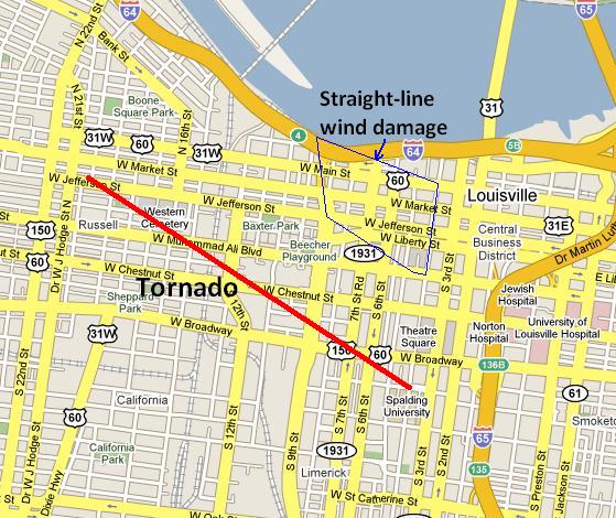