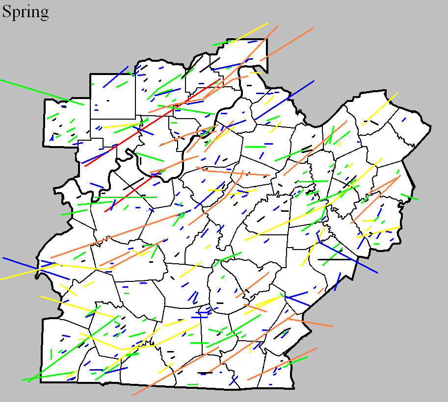

March 19, 1849
Counties: Breckinridge
F-scale:
Deaths:
Injuries:
Path width:
Path length:
Time:
Narrative: Tornado hit Big Spring. Possibly a significant tornado, comparable to a tornado in the same area March 27, 1890.
April 30, 1852
Counties: Scott KY
F-scale:
Deaths:
Injuries:
Path width:
Path length:
Time:
Narrative: A possible tornado hit four miles north of Georgetown.
April 13, 1876
Counties: Jefferson KY
F-scale: F2
Deaths: 2
Injuries: 10
Path width: 50 yards
Path length: 3 miles
Time: 6:30pm
Narrative: A tornado touched down west of present-day University of Louisville and moved to the north-northeast across eastern sections of the city. The tornado struck the brand new baseball park, located where Saint James Court is today, built to host Louisville's new National League baseball team, the Louisville Grays. The park was badly damaged, just 12 days before the season's Opening Day. The park was quickly repaired and was ready to go in time for the first pitch. The tornado continued northeast across the land that would become Central Park, and into Eagle Park between Ormsby and Park Avenues and Third and Fifth Streets. Eagle Park was Louisville's baseball park before the new one to the south was constructed. Eagle Park was demolished, and the baseball diamond's bleachers were destroyed. Damage was then fairly sparse until the tornado entered the Germantown and Phoenix Hill neighborhoods. Germantown was hardest hit. A two story brick home was damaged "about as complete(ly) as it could possibly be" and a man and his son were killed in the home, on the northeast corner of Payne and Logan Streets (those streets do not intersect today, so this exact location is unknown). Mills on Broadway at Beargrass Creek were wrecked. Houses were severely damaged on Green Street (now Liberty Street) near Campbell. Blacksmith shops on Preston "near the railroad crossing (?) were blown down. Half a dozen houses were damaged on Milk Street (?) at Shelby Street. The Exposition Building and its skating rink were damaged. Light damage was reported on Walnut Street (now Muhammad Ali Blvd). Most of the injuries in the tornado were in a street car that was hit by the roof of a house. Click here for a detailed map of the approximate path of the tornado.
March 2, 1878
Counties: Casey
F-scale: F4
Deaths: 8
Injuries:
Path width: 400 yards
Path length:
Time: 2:30pm
Narrative: A tornado near Rich Hill and Mount Olive moved northeast and swept away dwellings, large trees, horses, cattle, and other stock. Near Rich Hill, one family of seven was killed. The mother was blown 400 yards, and her two daughters "with arms interlocked" were blown 50 yards. One other death occurred in the village of Mount Olive, where several homes were destroyed.
March 20, 1882
Counties: Fayette
F-scale: F2
Deaths: 0
Injuries: 1
Path width:
Path length:
Time:
Narrative: Hit the northern part of Lexington. Houses were unroofed. Barns and the L&N roundhouse were flattened. The roof was torn off of the Tarr Distillery at 899 Manchester Street. According to the (Lexington) Weekly Press, the roof of "Mr. Sharp's house on the hill" was removed, and two chimneys were destroyed at the home of Mr. Bassett. One person was severely injured, and may have died later.
April 22, 1887
Counties: Warren
F-scale: F2
Deaths: 0
Injuries: 5
Path width: 125 yards
Path length: 3 miles
Time:
Narrative: A tornado hit near Boat Island on the Barren River. One home and at least six barns were destroyed.
April 22, 1887
Counties: Bourbon
F-scale: F2
Deaths: 0
Injuries: 0
Path width: 400 yards
Path length:
Time: 8:00am
Notes: More specific information is needed to accurately map this tornado. A tornado leveled trees and unroofed houses along a track 400 yards wide "at Paris" or "near Paris" (depending on the source used). White's Distillery's roof was blown "out of sight." The Turney, Clark, and Company livery stable was blown across the street. Mrs. Herrick's boarding house was nearly demolished, and the Paris Flour Mill's roof was damaged. Mrs. Carson's roof was carried across the street. The Daily Press said, "A tornado struck the city with inconceivable energy." While there were heavy property losses, no one was killed.
April 28, 1887
Counties: Clark KY
F-scale: F2
Deaths:
Injuries:
Path width:
Path length:
Time: 5:00pm
Narrative: Homes and barns were destroyed at Wade's Mill.
March 27, 1890
Counties: Hancock (from Daviess)
F-scale: F2
Deaths: 2
Injuries: 15
Path width:
Path length: 10 miles
Time: 7:00pm
Narrative: One of central Kentucky's darkest days began when a tornado moved northeast from south of Knottsville to north of Patesville. Two people died in homes that were destroyed.
March 27, 1890
Counties: Jefferson KY, Clark IN
F-scale: F4
Deaths: 76
Injuries: 200
Path width: 300 yards
Path length: 15 miles
Time: 7:57pm
Narrative: One of the most devastating tornadoes to ever strike Kentucky. This historic event may have actually started in Harrison County IN, but is traditionally plotted from west of Shively, Kentucky, in western Jefferson County. The tornado moved north-northeast and northeast through the Parkland neighborhood (Twenty-eighth and Dumesnil), leveling a few homes. This F4 damage was the only clear example of F4 strength winds along the path. However, when the tornado entered the city of Louisville it was 200 yards wide and grew to 500 yards wide as it plowed through the central business district downtown. Multi-story downtown buildings were hit by the tornado and subsequently collapsed. At least 44 deaths occurred at the Falls City Hall (1124 West Market Street). The building collapsed with 200 people inside; 75 at a lodge meeting on the upper floor and 125 children with their mothers taking dancing lessons on the lower floor. This was one of the highest tornado death totals in a single building ever recorded in the United States. Damage totalled $2.5 million (1890 dollars) in Jefferson County, with another half a million dollars with F2 intensity damage in Jeffersonville IN...along with 20 injuries. The tornado then turned to the right and re-crossed the Ohio River, coming back into Louisville dissipating near the present-day intersection of Zorn Avenue and River Road after badly damaging the city water tower. 5 churches, 7 railroad depots, 2 public halls, 3 schools, 10 tobacco warehouses, 32 manufacturing plants and 532 dwellings were destroyed by the tornado. Union Station was crushed as well. The next morning the newspaper called the storm "the whirling tiger of the air". The city organized crews of 60 men each who worked day and night searching the wreckage, along with families and friends. Sightseers started arriving the next day, and the Guard was called to control the crowds. The City refused any outside aid. The Board of Trade organized a relief committee to oversee the recovery, and the Board also authorized $15,000 in pensions to widows and orphans of the storm.
March 27, 1890
Counties: Ohio, Grayson, Breckinridge, Hardin
F-scale: F4
Deaths: 7
Injuries: 40
Path width: 1200 yards
Path length: 60 miles (probably a family of tornadoes)
Time: 8:00pm
Narrative: Moved east-northeast from seven miles northwest of Hartford. Many miles of forest were leveled, and small farm communities were wiped out. Homes were said to have "vanished" near Sulphur Springs (where two people were killed) and near Falls of Rough (where three people were killed). The last damage was near Rineyville, where two people were killed in one home.
March 27, 1890
Counties: Shelby, Henry
F-scale: F3
Deaths: 3
Injuries: 10
Path width: 150 yards
Path length: 5 miles
Time: 8:15pm
Narrative: Moved northeast from four miles south of Eminence, passing one mile north of Pleasureville. Four farm houses were destroyed, and three members of a family were killed in one of them.
March 27, 1890
Counties: Allen, Barren
F-scale: F3
Deaths: 4
Injuries: 25
Path width: 600 yards
Path length: 15 miles
Time: 9:00pm
Narrative: Moved northeast from five miles south of Scottsville to near Tracy. Four people were killed in Allen County as at least three homes were destroyed. Death toll may have been as high as 17.
April 4, 1892
Counties: Logan
F-scale: F2
Deaths: 0
Injuries: 15
Path width: 150 yards
Path length: 4 miles
Time: 11:30pm
Narrative: Moved north, passing seven miles west of Russellville. At least five small homes were destroyed. Two people may have died.
March 23, 1893
Counties: Lincoln
F-scale: F2
Deaths: 0
Injuries: 3
Path width: 200 yards
Path length: 5 miles
Time:
Narrative: Moved east from the southeast edge of Stanford, passing near Rowland, two miles east of Stanford. Homes and businesses were destroyed. Mail from the post office was found up to two miles away.
May 26, 1894
Counties: Clark
F-scale: F2
Deaths: 0
Injuries: 0
Path width:
Path length: 5 miles
Time:
Narrative: Moved east (northeast?) from the east edge of Jeffersonville. Barns were destroyed five miles east of town.
April 3, 1903
Counties: Crawford, Harrison IN
F-scale: F2
Deaths: 1
Injuries: 6
Path width:
Path length: 16 miles
Time: 1:00pm
Narrative: Moved east-northeast from near Grantsburg to northwest of Hancock. One man was killed, and his son may have died as two homes were destroyed three miles southeast of English. The tornado was said to have been "thrashing about like the tail of a mad beast".
March 23, 1917
Counties: Harrison IN, Floyd, Clark IN, Jefferson KY
F-scale: F4
Deaths: 46
Injuries: 250
Path width: 400 yards
Path length: 33 miles
Time: 3:08pm
Narrative: One of the worst tornadoes in Kentuckiana's history. This large tornado passed one mile north of Corydon as it moved east across central Harrison County. Many farm buildings were damaged, and one farm was almost completely blown away. Its occupant was found in a ditch 200 feet from the foundation, unconscious, critically injured, and holding her unharmed baby. The twister moved east-northeast from three miles west of New Albany and cut a swath of death and destruction through the north side of town. Damage totaled $1,500,000 as 500 homes were destroyed, along with two schools and many other buildings. While many homes were swept away, the deaths were concentrated in groups, including at least five (possibly 12) deaths at the Olden Street School, eight deaths at a wood specialties plant, and five deaths in one home. Some children were killed on their way home from school. The tornado dissipated after striking Harrod's Creek, Kentucky.
Note: Grazulis counts this as two tornadoes, with a gap in the path at the Harrison/Floyd County line. More recent research by Gary Purlee and Cody Moore indicate that this was actually one tornado.
May 8, 1918
Counties: Warren
F-scale: F2
Deaths: 2
Injuries: 7
Path width:
Path length: 5 miles
Time: afternoon
Narrative: Barns or outbuildings were destroyed on eight farms. Two people died in a turnip house on the Wright Farm near Oakland. Wheat, orchard grass, strawberries, and garden crops were ruined near Smith's Grove. The Cook Hazelip Building in Smith's Grove was unroofed. Trees and telephone poles were knocked down.
March 24, 1921
Counties: Scott KY
F-scale: F2
Deaths: 0
Injuries: 0
Path width:
Path length: 5 miles
Time:
Notes: This tornado touched down near Watkinsville and moved northeast. Barns, power poles, and trees were immediately blown down. Some trees were uprooted and blown 20 feet. Additional barns were destroyed on the Wiley and Bramlett farms. The tornado quickly grew to 3/4 of a mile wide, and uprooted an entire orchard (nearly 100 trees) on the Green Farm west of Stamping Ground. A chicken house was blown away, killing 92 of the 100 chickens within. The Cook Farm suffered two destroyed barns and a badly damaged house. As the tornado neared Stamping Ground, it narrowed to 1/4 mile wide, and then lifted just northeast of town. W. A. Mitchell of the Lexington Weather Bureau office felt that the damage was straight-line winds (why he felt this way is unknown, and this project will instead agree with Grazulis that this was a true tornado). The tornado may have dipped very briefly to earth again on or near Cincinnati Road south of Double Culvert, though no specific damage reports have been found from that area. Witnesses described a "funnel-shaped cloud whirling along at high speed" that "sounded like a train coming across a railroad trestle" with debris circulating the funnel. Near the tornado's touchdown point the twister was followed by hail that greatly damaged fruit trees.
March 24, 1921
Counties: Madison
F-scale: F3
Deaths: 0
Injuries: 5
Path width:
Path length:
Time:
Narrative: This tornado hit the Kirksville and Silver Creek areas. Debris from one home blocked the railroad tracks for three hours. Two people received injuries when a chimney fell on them and broke their ribs. Several houses were reduced to kindling, and one tenant house was "blown completely away" near Silver Creek. One boy received a broken leg. Warwick Distillery at Silver Creek lost its roof. Near Kirksville one home was demolished and another lost its roof. A parlor rug from the house that lost its roof was later found in Phil Arbuckle's pasture, torn to rags, a mile away. One farmer witnessed a "funnel shaped cloud accompanied by a roar" like a truck at Silver Creek.
March 18, 1925
Counties: Allen, Barren, Monroe, Metcalfe (from Sumner TN)
F-scale: F4
Deaths: 39
Injuries: 95
Path width: 400 yards
Path length: 60 miles (probably a family of tornadoes)
Time: 5:00pm
Narrative: From one of the worst tornado outbreaks ever to strike central Kentucky. This tornado moved east-northeast from near Buck Lodge, eight miles north of Gallatin. Homes were swept away in many communities, including Keytown, Angle, Oak Grove, and Liberty. As many as eight people died in one home. Trees were blown down in the steep valleys as well as on the hilltops. At least 27 people died in Tennessee. Crossing into Kentucky, the tornado struck Mt. Union (near the present-day intersection of KY 1421 and Napier Road) and then Holland, killing four. The funnel may have either weakened or lifted over southern Barren County before striking Beaumont in Metcalfe County. There it killed eight more, including five in one family. Over 150 homes were damaged or destroyed.
March 18, 1925
Counties: Harrison IN, Jefferson KY
F-scale: F4
Deaths: 4
Injuries: 60
Path width: 1200 yards
Path length: 18 miles
Time: 5:15pm
Narrative: Moved to the east-northeast from Mauckport to just south of Louisville. Up to a mile wide, this very intense tornado swept away entire farms as it passed one mile north of Laconia and two miles south of Elizabeth. Furniture from Indiana was later found in yards in Pleasure Ridge Park, KY. The four deaths were in two separate Indiana farm homes. Jefferson County locations that were struck by the tornado or its parent thunderstorm included Orell, Greenwood Station, Kerrick Station, Blanton Station, Saint Helens, South park, Iroquois Park, and Senning's Park. The worst damage was on Eightheenth Street Road (likely today's Dixie Highway) from Lakeland to Blanton Station (the Pleasure Ridge Park/Dixie Manor Shopping Center area today). Three people were killed there. Nothing was left standing from the river to Blanton Station in a swatch two blocks wide. The twister crossed Cane Run Road and demolished a home on Greenwood Road. Damage was severe at Saint Helens, with one house completely removed except for one interior room. A two-story brick home was destroyed at Lakeland. Trees and power lines were torn down along Eighteenth Street Road from Kerrick Station to Greenwood Road...a distance of about a mile. Garages were destroyed in Senning's Park (site of Louisville's zoo at the time, located across New Cut Road from the Iroquois Amphitheater). Fifty large trees were uprooted in Iroquois Park, and smaller trees were witnessed sailing through the air. Power poles were torn down along New Cut Road. There was minor damage along Inverness Avenue northeast of Iroquois Park. A "queer greenish light" was reported before the storm hit. Hail up to 2 inches in diameter fell with the storm. The day after the storm the head of the Louisville weather service office, J. L. Kendall, surveyed the damage. he noted that the width of the tornado was 100 yards where it crossed Eighteenth Street Road, and widened to 500 yards as it entered Iroquois Park. Timber between the river and Eighteenth Street Road along Greenwood Road was observed to have been felled pointing to a common center.
March 18, 1925
Counties: Jefferson KY, Oldham
F-scale: F3
Deaths: 3
Injuries: 40
Path width:
Path length: 10 miles
Time: 6:00pm
Narrative: Moved northeast from the east edge of Louisville to near Pewee Valley. At least a dozen homes were destroyed. An injured person at Pewee Valley may have died several weeks later. This tornado was probably spawned from the same thunderstorm that produced the earlier tornado in southwest Louisville (see previous entry). It appears to have touched down at Hike's Point along Taylorsville Road and Brown's Lane. Barns and outhouses were levelled, roofs were blown off, and a car was overturned. The tornado moved to the northeast through present-day Saint Regis Park and Hurstbourne. The twister may have lifted briefly as it crossed Shelbyville Road very near Eight Mile House (which was unaffected). The tornado caused intermittent damage through Anchorage, and then grew in intensity and remained on the ground from O'Bannon into Pewee Valley. The twister was 1/4 mile wide as it entered Pewee Valley where it destroyed a three-story brick home and a two-story frame house. A two-story house in Pewee Valley was swept ten feet off its foundation and collapsed. Trees blocked the Louisville-Pewee Valley road for two miles. Immediately after the storm, Lagrange Interurban cars leaving Louisville could not get beyond Lyndon. Two days after the tornado the tracks were still blocked beginning at O'Bannon Station. Hail up to 2 1/4 inches in diameter pounded Crescent Hill, and the stones had large "horns" on them.
March 18, 1925
Counties: Marion, Washington KY, Mercer, Jessamine, Fayette, Bourbon
F-scale: F3
Deaths: 2
Injuries: 40
Path width: 300 yards
Path length: 60 miles (skipping)
Time: 6:30pm
Notes: What was almost certainly a family of tornadoes moved northeast from western Marion County (according to Grazulis) to 4 miles southwest of Paris in Bourbon County. This project has so far been unable to find any damage in Marion or Jessamine Counties. In Washington County many buildings across the county were leveled. The country home of Judge Case near Springfield was unroofed. The "Negro section" of Jimtown was destroyed, and all 25 houses in Jimtown were razed after the storm. In Springfield 30 people were injured and 2 were killed (the two fatalities may have been from Jimtown). Moving into Mercer County, two barns were lost on the Bond Farm. A barn was damaged and a house unroofed on the Terhune Farm, barns were blown down on the Quartz and Shelton Farms, a house and a barn were lost on the Sanford Farm, and the home of Kye Crossfield at Ebenezer was destroyed. The tornado was 1/4 mile wide in Mercer County. After possibly weakening or lifting in Jessamine County, the tornado slammed into eastern sections of Fayette County with renewed vigor. Trees were blown down on Chilesburg Road, and many trees and fences were torn down on the John E. Madden Farm on Winchester Road about four miles out of Lexington (roughly where Winchester Road meets I-75 today). The tornado reached its peak strength, high-end F3 (possibly F4) over a four-mile stretch of eastern Fayette County. About five and a half miles from Lexington on Briar Hill Road the twister devastated the Kelley Farm. Mrs. Kelley's 40-year-old "Negro hired hand" was blown 300 yards to his death. Nearly every bone in his body was broken. His right hip was dislocated to the point where it was alongside his chest. No trace of his cabin was ever found. The two-story eight-room main residence was "torn from its foundations" and reduced to a pile of rubble. The farm's chickens were stripped of their feathers. According to witnesses, the tornado was "cone-shaped and had a large black cloud at its top, coming out of the west. A pillar of flame shot skyward when the vortex of the twister struck the Kelley residence." Trees and telephone poles were blown down for a mile along Briar Hill Road. The Jonas Weil Farm on Briar Hill Road suffered an unroofed home, two miles of destroyed fence, and 500 felled trees. Moving along to the northeast, the Muir area was next in line (near the intersection of KY 1970 and KY 1973 today). William Johnson's residence on Muir Pike was "piled upon its foundations and partly blown away." The Deaver Farm was damaged, and a 15 pound rock was blown through a wall like a cannonball. Many trees were blown down. Proceeding into Bourbon County, the house of Rodes Donald had two rooms blown away, the Dudley School was moved four feet off its foundation, fifty trees were blown down on the Ewing Farm, and the Spears Farm on Stewart Road was damaged. The tornado then finally began to weaken and it dissipated about four miles shy of Paris.
May 9, 1933
Counties: Monroe, Cumberland, Adair, Russell
F-scale: F4
Deaths: 36
Injuries: 87
Path width: 800 yards
Path length: 60 miles (probably a family of tornadoes)
Time: 8:30pm
Notes: This historic event began around 8pm when there was 30 minutes of rain and hail in Tompkinsville, followed by five minutes of absolute calm. The calm was shattered when a tornado touched down just southwest of town and moved northeast, directly into southern sections the city (the "Negro section," as newspapers called it at the time). The path of utter destruction, in which everything was flattened, was a quarter mile wide. The damaged residences of O. C. Landrum and Oscar Sims marked the edges of the devastation. Between them was a treeless and fenceless waste, with scattered remnants of homes and uprooted trees. A heavy rain, which fell continuously from 1 o'clock until 6 the following morning, made roads almost impassable and handicapped the work of rehabilitation. Only three homes that were affected by the funnel were able to be salvaged. World War I veterans described the devastation and suffering as worse than what they witnessed during the Great War. The twisting nature of the winds was clearly revealed when the bodies of the Tyree family were found 75 yards south of their home site, and the bodies of the Redeford family were discovered 100 yards north of the spot where their home had stood. The Tyrees lived on the southern edge of the storm area, while the Redefords lived near the northern edge. The body of the Rev. Redeford's wife was carried 150 yards to a pond on the land belonging to L. P. Hagan. The corpse of the husband was found entangled in a barbed wire fence, having been blown about one hundred yards. Sixteen people in Tompkinsville lost their lives that evening, with another 2 deaths just northeast of town in Sewell. Fifty citizens were injured in Monroe County. After Tompkinsville, the tornado continued to the northeast, crossing Cumberland County (2 people injured) and clipping the southeast corner of Adair County (2 people killed in the Cundiff area) with comparatively little damage, before intensifying again as it entered Russell County. The tornado grew into a mile-wide monster as it plowed down at least 100 homes. The edge of the tornado missed downtown Russell Springs by only half a mile. The tornado spent its last fury in the Happy Acre area, causing damage along Goose Creek, near Friendship Church, and on the southern end of Bethany Ridge where chickens were stripped of their feathers. The tornado lifted at the Casey County line. Fatality counts for Russell County vary from 14 to 20 depending on the source...this study will use Grazulis' number of 18. Of those 18, 14 were killed on the southeast edge of Russell Springs. Up to 100 people may have been injured in Russell County.
May 9, 1933
Counties: Metcalfe, Adair
F-scale: F2
Deaths: 2
Injuries: 12
Path width: 400 yards
Path length: 15 miles
Time: 8:30pm
Narrative: Moved northeast, destroying five homes and damaging a dozen others at Columbia.
March 24, 1937
Counties: Fayette, Clark KY
F-scale: F4
Deaths: 5
Injuries: 28
Path width: 150 yards
Path length: 15 miles
Time: 5:50pm
Notes: This major tornado touched down in Fayette County between Athens and Boone Creek, probably between Gentry Road and Athens-Boonesboro Road. Only one structure was destroyed in Fayette County, which was a barn on the Scott Farm when the tornado was about 200 yards wide and less than a minute old. The tornado grew in strength very rapidly, and after traveling only about a mile it crossed Boone Creek and completely swept away a house on the Clark County side of the creek. A four-year-old girl in the house was blown 200 yards and survived with a broken leg. The storm continued to the northeast through Becknerville (where the funnel was 400 yards wide), with its sights set on Winchester. The storm roared across Two Mile Pike and into the southern and eastern outskirts of the city. The worst of the storm hit a section variously called, among different sources, "the Patio," "Patio Pike," and "Patio Station," which is believed to be in the vicinity of the intersection of modern-day Patio Street and Hamilton Street along the railroad tracks. Here a 9-year-old boy was partially scalped and suffered a fractured skull. One hundred buildings were leveled and parts of houses were found half a mile away. Only three houses remained standing on the far east side of Winchester. A witness on a high spot on East Broadway witnessed the tornado decimate the Patio/Muddy Creek Pike area around 6pm. The tornado was a "funnel-shaped spiral, light gray at the top and black at the bottom." The tornado continued northeast, crossing Irving Road and Ironworks Road, finally dissipating five miles east of Winchester. It was noted in the local press that the tornado never left the ground along its 15 mile path, and made a "clean sweep" of the earth. It was called the worst storm in the history of Clark County, and probably still is (rivaled only by the April 3, 1974 tornado). Though the tornado missed central Winchester, the city was pummeled by hail up to 4" in diameter (grapefruit sized) that damaged roofs, ripped car tops, and covered the ground like snow. The hailstones had "long icicles" on them. Click here for a map showing the approximate path of the tornado through Winchester.
March 16, 1942
Counties: Grayson, Hardin
F-scale: F4
Deaths: 9
Injuries: 40
Path width: 200 yards
Path length: 30 miles
Time: 6:15pm
Narrative: Moved east-northeast from north of Caneyville to near Summit. People died in seven different homes north of Caneyville, Millwood, Leitchfield, Clarkson, and Summit. About twenty homes were destroyed, and some were swept completely away. Two of the deaths were in Hardin County.
March 16, 1942
Counties: Nelson
F-scale: F3
Deaths: 4
Injuries: 20
Path width: 200 yards
Path length: 15 miles
Time: 7:30pm
Narrative: Moved east-northeast, passing north of Bardstown, killing people in three different homes. Rural homes were leveled from near Deatsville to Cox's Creek.
March 19, 1943
Counties: Harrison, IN
F-scale: F2
Deaths: 0
Injuries: 2
Path width: 400 yards
Path length:
Time: 2:15pm
Narrative: Moved northeast at Laconia, ripping the roof and a wall off the Laconia school. Only two of the 150 students were injured.
May 15, 1945
Counties: Clark, IN
F-scale: F2
Deaths: 0
Injuries: 0
Path width: 100 yards
Path length: 1/2 mile
Time: 7:45pm
Narrative: Two large factory buildings and a warehouse at the American Car and Foundry plant were destroyed in Jeffersonville, halting production of much-needed naval artillery. Slight roof damage occurred at the corner of Walnut and Court Streets. The damage was surveyed by the chief of the Louisville weather station, E. E. Unger. Click here for a close-up map of the approximate path.
April 8, 1948
Counties: Fayette
F-scale: F2
Deaths: 1
Injuries: 4
Path width: 200 yards
Path length:
Time: 2:00pm
Narrative: A "bounding-type" tornado destroyed barns and stables at the Keeneland Race Track. A groom was killed. Minimal F2.
April 12, 1948
Counties: Madison
F-scale: F2
Deaths: 0
Injuries: 0
Path width:
Path length:
Time: 4:45am
Narrative: Large buildings were destroyed at the Bluegrass Ordnance Depot at Richmond.
May 2, 1948
Counties: Clinton (to Wayne)
F-scale: F4
Deaths: 5
Injuries: 60
Path width: 300 yards
Path length: 10 miles
Time: 7:00pm
Grazulis narrative: Moved east-northeast, leveling homes near Alpha, Sumter, and Copper. Three people were killed in a home near Alpha and two in a home near Sumter. Most of the injuries were in a church that was torn apart and collapsed during evening services.
March 22, 1952
Counties: LaRue
F-scale: F3
Deaths:
Injuries: 18
Path width: 300 yards
Path length:
Time: 12:05am
Grazulis Narrative: Moved northeast across the south part of Hodgenville. The tornado destroyed nine cottages as well as the county fairgrounds. A dozen other homes were unroofed. About forty other homes had minor damage.
Noted discrepancies: SPC, Grazulis, and Storm Data give a time of 12:05am, NCDC 12:03am. SPC gives a path width of 10 yards, NCDC 30 yards, Grazulis 100 yards, Storm Data 300 yards. Would tend to believe Storm Data's width.
April 6, 1954
Counties: Dubois
F-scale: F2
Deaths:
Injuries:
Path width: 30 yards
Path length:
Time: 7:00am
Noted discrepancies: SPC and NCDC list this as an F2, Grazulis does not list it. SPC gives a path width of 10 yards, NCDC gives 30 yards.
May 2, 1954
Counties: Ohio
F-scale: F1
Deaths:
Injuries:
Path width: 25 yards
Path length:
Time: Noon
Noted discrepancies: SPC gives a path width of 10 yards, NCDC gives 30 yards, Storm Data says 25 yards.
March 4, 1955
Counties: Madison
F-scale: F3
Deaths: 0
Injuries: 2
Path width: 250 yards
Path length: 5 miles
Time: 6:45pm
Grazulis Narrative: Moved east from Cottonburg to south of Richmond. Two homes and several barns were destroyed. Ten cows were killed.
Noted discrepancies: SPC and NCDC call this an F3, Grazulis calls it an F2. SPC and NCDC give it a path length of 9 miles, Grazulis and Storm Data give a length of 5 miles. SPC gives a path width of 10 yards, NCDC 30 yards, and Grazulis and Storm Data 250 yards. (Grazulis and Storm Data list the touchdown at "Cottonwood", by which they probably mean "Cottonburg", which is west of Richmond two miles east of the Garrard County line.)
April 24, 1955
Counties: Madison
F-scale: F1
Deaths: 0
Injuries: 2
Path width: 800 yards
Path length: 3 miles
Time: 3:45am
Grazulis Narrative: Moved northeast near Eastern State College in Richmond. Homes were unroofed in the student housing area. Hundreds of trees were uprooted.
Noted discrepancies: Grazulis lists this tornado as having occurred at 3:00am...Storm Data lists it at 3:45am...SPC lists it at 3:45pm. Storm Data also mentions it lifted at 4:00am. Would tend to believe Storm Data here. Storm Data says most damage was in and around Eastern State College in Richmond. Grazulis lists this tornado as an F2.
March 7, 1956
Counties: Washington IN
F-scale: F2
Deaths:
Injuries:
Path width:
Path length:
Time: 12:10am
Noted discrepancies: SPC and NCDC list this as an F2...Grazulis does not list it. SPC and Storm Data give a time of 12:10am, NCDC gives 12:06am. SPC gives a path width of 10 yards, NCDC says 30 yards. Storm Data says it struck one mile south of Salem and moved east.
April 3, 1956
Counties: Washington IN
F-scale: F2
Deaths: 0
Injuries: 12
Path width: 150 yards
Path length: 23 miles
Time: 5:45pm
Grazulis Narrative: Moved northeast from seven miles southwest of Salem to near Little York. A large bridge five miles southwest of Salem was moved. Over a hundred buildings were damaged or destroyed. A church and a school were struck at Canton. A freezer was reportedly carried half a mile from the home site. Newspapers called this a "barnado" because of the large number of barns destroyed. One of the women injured in this tornado would be killed by another tornado on March 19, 1963.
Noted discrepancies: SPC and NCDC list this as an F2, Grazulis says F3. SPC gives a path length of 1/10 of a mile...NCDC gives nothing...Grazulis gives 15 miles...Storm Data gives 23 miles. SPC gives a path width of 10 yards...NCDC gives nothing...Grazulis and Storm Data say 150 yards. SPC and NCDC list only a touchdown point...no lift-off point is given.
April 3, 1957
Counties: Warren
F-scale: F1
Deaths:
Injuries:
Path width:
Path length:
Time: 5:30pm
Grazulis Narrative:
Noted discrepancies: SPC gives a path length of 1/10 of a mile...NCDC gives nothing. SPC gives a path width of 10 yards, NCDC gives nothing.
April 2, 1958
Counties: Logan
F-scale: F1
Deaths:
Injuries: 1
Path width:
Path length:
Time: 2:20pm
Noted discrepancies: SPC gives a path length of 1/10 of a mile...NCDC gives nothing. SPC gives a path width of 10 yards, NCDC gives nothing.
April 20, 1958
Counties: Washington IN
F-scale: F1
Deaths:
Injuries:
Path width:
Path length:
Time: 4:00pm
Noted discrepancies: None.
April 20, 1958
Counties: Madison
F-scale: F1
Deaths:
Injuries:
Path width:
Path length:
Time: 4:30pm
Noted discrepancies: SPC gives a path length of 1/10 of a mile...NCDC gives nothing. SPC gives a path width of 10 yards, NCDC gives nothing.
April 22, 1958
Counties: Warren
F-scale: F1
Deaths:
Injuries:
Path width:
Path length:
Time: 9:00am
Noted discrepancies: SPC gives a path length of 1/10 of a mile...NCDC gives nothing. SPC gives a path width of 10 yards, NCDC gives nothing.
March 6, 1961
Counties: Scott IN
F-scale: F2
Deaths: 0
Injuries 3
Path width: 50 yards
Path length: 2 miles
Time: 7:06am
Grazulis narrative: Moved northeast through the northwest corner of Austin. Eight smokestacks were toppled at a canning plant, and the roof was ripped off a house. Injuries occurred when three trailers were destroyed.
Noted discrepancies: SPC gives a path width of 10 yards, NCDC 30 yards, Grazulis 50 yards.
March 6, 1961
Counties: Dubois
F-scale: F1
Deaths:
Injuries:
Path width:
Path length:
Time: 8:00am
Noted discrepancies: SPC gives a path width of 10 yards, NCDC 30 yards. Storm Data says this tornado moved from southwest of Ferdinand to Siberia (Siberia proper is actually in Perry County, just over the county line). The ending lat/lon given is just inside Perry County as well. Will map as such, but further research would be helpful.
March 6, 1961
Counties: Clark IN
F-scale:
Deaths:
Injuries:
Path width:
Path length:
Time: 10:00am
Noted discrepancies: SPC gives a path length of 1/10 of a mile, NCDC gives nothing. SPC gives a path width of 10 yards, NCDC gives nothing. SPC and NCDC give no F-scale rating, and it's not listed in Grazulis. Storm Data says a pole barn was reduced to rubble along IN 160 northwest of Charlestown. However the lat/lon given doesn't quite agree with that location. More research is necessary.
May 7, 1961
Counties: Ohio, Grayson (from Hopkins and Muhlenberg)
F-scale: F3
Deaths:
Injuries:
Path width:
Path length:
Time: 9:25am
Grazulis narrative: Skipped east-northeast from Madisonville to Bremen, Moorman, and on to Beaver Dam. The Moorman High School gym was unroofed and a small home fell over.
Noted discrepancies: SPC and NCDC rank this as an F3, Grazulis gives it an F2. Grazulis does not include Grayson County. SPC, Storm Data, and NCDC give a time of 9:25am, Grazulis give 8:15am. SPC and NCDC give a path length of 58 miles, Grazulis give 35 miles (skipping), Storm Data gives 60 miles. SPC and NCDC give a path width of 880 yards, Storm Data says 1320 yards, Grazulis says 200 yards. This tornado is very oddly listed at the NCDC website. NCDC lists Hopkins County at 9:25am, then two entries for Muhlenberg County (one at 9:36am and the other at 9:41am), then two entries for Ohio County (one at 9:48am and the other at 9:56am), then one entry for Grayson County (at 10:17am). All entries have identical f-scale and path widths values. Storm Data begins the tornado in McLean County, and thereafter agrees with SPC. The NCDC end lat/lon of the first Muhlenberg tornado is the same as the NCDC begin lat/lon of the second. Similarly, the NCDC end lat/lon of the first Ohio tornado is the same as the NCDC begin lat/lon of the second. All lat/lons are roughly in alignment with each other and with the Grayson County lat/lons. Will plot a single tornado as close to the given lat/lons as possible. In the LMK CWFA, only Centertown and Beaver Dam (both Ohio County) are mentioned in the Storm Data narrative. More research would be nice, especially to determine if this tornado did continue into Grayson County or not.
March 21, 1962
Counties: Fayette
F-scale: F1
Deaths: 0
Injuries: 0
Path width:
Path length: 1/3 of a mile
Time: 9:00am
Grazulis narrative: At Blueberry Hill, two barns were "blown up and flattened" by a tornado that touched down south of Lexington.
Noted discrepancies: SPC and NCDC list this as an F1, Grazulis calls it an F2. SPC gives a path width of 10 yards, NCDC 30 yards, Grazulis nothing. Grazulis lists it at 10:00am.
March 16, 1963
Counties: Washington IN
F-scale: F2
Deaths: 0
Injuries: 0
Path width: 100 yards
Path length: 1 mile
Time: 5:20pm
Grazulis narrative: Moved east-northeast from five miles southeast of Salem. Farm buildings on one farm, and a house on another farm, were destroyed.
Noted discrepancies: SPC and NCDC give this a path width of 800 yards, Grazulis and Storm Data give 100 yards. Storm Data says this tornado hit four and a half miles southeast of Salem near IN 60 (present-day IN 160?) and the Middle Blue River.
March 19, 1963
Counties: Dubois
F-scale: F2
Deaths:
Injuries:
Path width:
Path length:
Time: 2:00pm
Noted discrepancies: SPC and NCDC rank this as an F2, but Grazulis does not list it. SPC gives a path length of 1/10 of a mile and a path width of 10 yards...NCDC gives nothing for either.
March 19, 1963
Counties: Washington IN
F-scale: F1
Deaths: 2
Injuries: 0
Path width:
Path length:
Time: 3:00pm
Grazulis narrative: Hit at Becks Mill. Two women were killed when their shelter collapsed onto them. The old fruit cellar behind the house may have been weakened by rain water and the sudden pressure change. Their home had only broken windows. One of the women had been injured in a tornado on April 3, 1956.
Noted discrepancies: SPC gives a path length of 1/10 of a mile and a path width of 10 yards...NCDC gives nothing for either.
April 21, 1963
Counties: Woodford
F-scale: F2
Deaths: 0
Injuries: 3
Path width: 200 yards
Path length: 2 miles
Time: 10:50pm
Grazulis narrative: Moved northeast from northeast of Versailles. Fourteen farm buildings were damaged and a tenant home was destroyed. (Storm Data says this tornado struck three and a half miles northeast of Versailles at Maplewood Farm.)
Noted discrepancies: None.
April 29, 1963
Counties: Logan
F-scale: F2
Deaths:
Injuries:
Path width:
Path length:
Time: 8:10pm
Noted discrepancies: SPC and NCDC list this as an F2, Grazulis does not list it. SPC gives a path width of 170 yards and a path length of 9 miles...NCDC gives nothing for either.
Notes: Storm Data says that the central and northern parts of Russellville were hardest hit, including the Kaintuck Hotel.
April 29, 1963
Counties: Edmonson
F-scale: F2
Deaths:
Injuries:
Path width:
Path length:
Time: 8:30pm
Noted discrepancies: SPC and NCDC list this as an F2, Grazulis does not list it. SPC gives a path width of 10 yards and a path length of 1/10 of a mile...NCDC gives nothing for either.
Notes: Storm Data says this tornado struck at Rocky Hill Crossroad.
March 4, 1964
Counties: Logan
F-scale: F3
Deaths: 0
Injuries: 5
Path width: 880 yards
Path length: 7 miles
Time: 2:25pm
Grazulis narrative: Moved northeast from two miles west of Adairville to Schochoh. A home was unroofed and tenant homes and barns were destroyed. Livestock was killed and cars and farm machinery were destroyed.
Noted discrepancies: SPC and NCDC gave this an F3, Grazulis gives an F2. SPC and NCDC give a path length of 7 miles, Grazulis and Storm Data give 8 miles. SPC, Storm Data, and NCDC give a path width of 880 yards, Grazulis gives 800 yards. The touchdown lat/lon listed by NCDC and SPC is in Hickman County, and the liftoff lat/lon is in Graves County (far western Kentucky). Grazulis takes the tornado from two miles west of Adairville to Schochoh, which agrees with Storm Data.
March 25, 1964
Counties: Franklin
F-scale: F1
Deaths: 0
Injuries: 0
Path width: 10 yards
Path length: 1/10 mile
Time: 6:00pm
Grazulis narrative: A small tornado demolished a barn and carried the barn timbers a half mile away from the barn site.
Noted discrepancies: SPC/NCDC call this an F1, Grazulis says F2. SPC gives a path length of 1/10 of a mile and a width of 10 yards...NCDC and Grazulis give nothing for either. The lat/lon pair for this tornado listed by SPC/NCDC put it in southern Floyd County Indiana. Grazulis lists the tornado in Franklin County but gives no location or path length. If SPC/NCDC's lat/lon is changed from -85.92 to -84.92, it is placed in Franklin County. More research would be nice, to confirm its location and to get a better handle on path width and length.
March 25, 1964
Counties: Jefferson KY, Shelby, Oldham, Henry
F-scale: F2
Deaths: 0
Injuries: 1
Path width: 30 yards
Path length:
Time: 7:00pm
Grazulis narrative: Skipped east-northeast from just east of Standiford Field to Smithfield and New Castle. The "bounding" tornado, and accompanying high winds, unroofed or damaged four homes, 31 barns, and fifty other buildings.
Jefferson County: The Jefferson County portion of the track was well-covered in the local newspapers. The tornado touched down on the east side of Louisville International Airport at the intersection of Standiford Lane and Preston Highway, where it lifted and blew a car 40 feet, depositing it on its roof. The tornado grew to about two blocks wide and tore the roof off of a home at 4503 Zeta Court, dropping it in the back yard. Also on Zeta Court a car was flipped over. At about the same time a truck was flipped over at 2420 Cavelle Avenue. The tornado may have weakened or lifted slightly as the storm moved through Watterson Park and West Buechel. Damage then occurred again when a frame home's garage was torn from its foundation at 2835 Klondike Lane and was thrown 100 feet into the side of Saint Martha Catholic Church. On Dale Ann Drive a playhouse weighing 1500 pounds was blown 200 feet. After causing comparatively little damage in Houston Acres, the tornado strengthened again and grew to a width of about three blocks. On Cardwell Way a carport collapsed, three homes were damaged, and a car was demolished. Meanwhile, siding was removed from a home at 58 Hallsdale Drive and a garage was destroyed next door at 60 Hallsdale Drive. The tornado may have again weakened or lifted as the storm crossed Blue Ridge Manor and Anchorage. The last damage report in Jefferson County was on Collins Lane where homes and commercial buildings were damaged, and roofs were removed from barns. The head of the weather service office in Louisville, O. K. Anderson, surveyed the damage and said there was no doubt in his mind that it was a small, bounding tornado. Click here for a map of the Jefferson County portion of this tornado track. Louisville newspapers did not mention any damage in Oldham or Shelby Counties. There was mention of tornado damage in Smithfield and just outside New Castle in Henry County.
Noted discrepancies: Grazulis does not include Shelby County. NCDC does not list Oldham County or Henry County, and lists Jefferson County twice. Storm Data lists only Jefferson and Henry counties. SPC, Storm Data, and NCDC give a time of 7:00pm, Grazulis give 7:25pm. SPC gives and endpoint lat/lon of 28.50/-85.12...NCDC give 38.22/-85.45. SPC, Storm Data, and NCDC list one injury...Grazulis lists none. SPC gives a path length of 38 miles, NCDC gives 33 miles, Storm Data says 40 miles, Grazulis lists a skipping path of 23 miles. SPC gives a path width of 10 yards, NCDC 30 yards, Grazulis 40 yards. The second of the two Jefferson County entries at NCDC lists the touchdown point with the exact same lat/lon as the liftoff point in the first Jefferson County entry. Grazulis does mention that the tornado skipped. The NCDC touchdown lat/lon in Shelby County is not the same as the liftoff lat/lon in Jefferson County, though it ought to be if the tornado went directly from Jefferson County into Shelby County as one coherent tornado, so perhaps at the NCDC website the Shelby County event is a separate tornado, and is also a separate tornado according to Grazulis who perhaps felt it was not F2 and thus omitted it...? Grazulis takes the twister from Jefferson County into Oldham County (instead of Shelby County) and on into Henry County (agreeing with SPC's database). The touchdown and liftoff lat/lon given by SPC/NCDC agree perfectly with Grazulis. Using the touchdown and liftoff lat/lons at SPC, this tornado would have missed Shelby County. The end lat/lon given by NCDC for Shelby County is actually located in Henry County. Storm Data narrative says, "A small tornado of the bounding type moved in a straight line west-southwest to east-northeast from about half a mile east of Standiford Field...to approximately ten miles northeast. Apparently the same tornado continued northeastward into Henry County. It touched down several times in Jefferson County, and in Henry County...in the vicinities of Smithfield and New Castle." More research is necessary.
May 26, 1965
Counties: Simpson
F-scale: F2
Deaths:
Injuries:
Path width: 100 yards
Path length:
Time: 10:15pm
Noted discrepancies: SPC and NCDC list this as an F2...Grazulis does not list it. SPC gives a path length of 1/10 of a mile...NCDC gives nothing. SPC and Storm Data give a path width of 100 yards, NCDC gives nothing.
April 21, 1967
Counties: Jefferson IN (from Jennings)
F-scale: F2
Deaths: 0
Injuries: 2
Path width:
Path length: 6 miles
Time: 5:10pm
Grazulis narrative: Moved east from Commiskey to Dupont. Two homes were unroofed and torn apart, injuring two people inside one of them. A trailer was demolished, and farm buildings were destroyed.
Noted discrepancies: SPC and NCDC give a path length of 6 miles, Grazulis gives 7. SPC gives a path width of 10 yards, NCDC 30 yards, Grazulis nothing.
May 14, 1967
Counties: Jessamine
F-scale: F0
Deaths:
Injuries:
Path width:
Path length:
Time: 7:00am
Noted discrepancies: SPC gives a path length of 1/10 of a mile and a width of 10 yards...NCDC gives nothing for either.
April 23, 1968
Counties: Jessamine
F-scale: F2
Deaths: 0
Injuries: 3
Path width: 75 yards
Path length: 3 miles
Time: 5:34pm
Grazulis narrative: Moved northeast at Nicholasville. A house was shifted off its foundation. Many homes had roof damage, and at least one was unroofed. A barn was picked up and scattered over 60 to 70 acres.
Notes: (This information was discovered on an internal Weather Bureau memo from Charles E. Hardy at WSO Lexington) The violent storm moved from the southwest part of Nicholasville near Shun Pike and reached the center of the city near the police station at Oak and Main. Near Lake Street some trees were felled and some monuments were overturned in Maple Grove Cemetery. An estimated number of 75 to 100 trees were uprooted or blown over. Some roofs on the southwest side of Nicholasville had the tin rolled or twisted toward the northeast. Several windows were broken in an elementary school, which was in session, and flying glass injured one student on their finger. Damage to houses and other buildings was mainly to roofs and windows of the upper floors. One house had its foundation shifted a few feet, and one roof was completely blown off. Power and telephone lines were downed. A car was overturned on Main Street. Mrs. Bloomfield, whose house was in the path of the storm, stated that she heard a noise like a jet airplane. Another witness, Patrolman Swallows of the police department, said he noticed a short appendage looking like a trail of smoke hanging down from the parent cloud and a noise like a freight train was heard. Mr Hammonds, another policeman on duty at the time of the storm, said that he noticed nothing like a funnel, but he observed a violent rotation apparently about a vertical axis in a black ominous looking cloud assoicated with the storm. Two women were injured by flying glass but the injuries were not serious.
Noted discrepancies: SPC and NCDC give 3 injuries, Grazulis gives 6, Storm Data gives 0. SPC and NCDC give a path width of 60 yards, Grazulis 80 yards, Storm Data 75 yards.
May 26, 1968
Counties: Warren
F-scale: F2
Deaths:
Injuries:
Path width:
Path length:
Time: 3:30pm
Grazulis narrative: One barn was destroyed and another was damaged at Smiths Grove.
Noted discrepancies: SPC gives a path length of 1/10 of a mile and a width of 10 yards...NCDC gives nothing for either.
May 8, 1969
Counties: Nelson
F-scale: F1
Deaths:
Injuries:
Path width:
Path length:
Time: 5:00pm
Noted discrepancies: SPC gives a path length of 1/10 of a mile and a width of 10 yards...NCDC gives nothing for either.
Notes: Storm Data says this tornado destroyed two barns in the Fairfield area.
May 8, 1969
Counties: Hart
F-scale: F1
Deaths: 0
Injuries: 1
Path width: 100 yards
Path length: 9 miles
Time: 6:15pm
Grazulis narrative: Moved northeast from three miles northeast of Horse Cave, to Uno, and on to Hardyville. Several houses and five barns were demolished. Most of the house damage was caused by falling trees.
Noted discrepancies: SPC and NCDC rank this as an F1, Grazulis gives it an F2. SPC and NCDC give it a path length of 9 miles, Grazulis and Storm Data give 8 miles. SPC and NCDC lat/lons start the tornado east of Horse Cave...Grazulis starts it northeast of Horse Cave.
Notes: Storm Data says this tornado struck three miles northeast of Horse Cave, and then to Uno and Hardyville, crossing KY 541 about two miles west of US 31E. However, KY 541 is in Breathitt County. Probably meant KY 571.
May 10, 1969
Counties: Bullitt
F-scale: F3
Deaths: 0
Injuries: 14
Path width: 300 yards
Path length: 4 miles
Time: 4:00pm EDT
Notes: (From internal Weather Bureau memo and from newspaper clippings) Eight homes destroyed, 29 damaged. Much of the tornado path was at tree top, and several residents within 1/2 mile of the storm were unaware of it due to lack of excessive winds or roar. The tornado touched down just west of the KY 480/I-65 junction, and moved east along Cedar Grove Road. The tornado did its worst damage at the beginning of its path where it demolished three homes on Dawson Drive. One lane of Interstate 65 was blocked by debris, and cars were damaged. Just east of I-65 a house trailer was lifted and deposited 100 feet away. Pieces of clothing, blankets, sheets, metal siding, and roofing were wrapped around uprooted trees and hanging from power lines. The path ended at the W.D. Miller farm. The Millers saw the vortex recede upward into the main cloud. Mr. Miller reported that a small whirlwind passed within a few hundred feet of his house, sucking out a storm window, uprooting a cedar tree, and depositing debris. Of the injured, 3 were serious enough to be hospitalized. Four-year-old Terry Harding, on Dawson Drive, suffered a fractured skull and severe head lacerations that required surgery. Timothy Dawson, 10, experienced a fractured leg. One man was sitting in his trailer when the tornado hit, and subsequently found himself sitting in a field after his trailer was carried away.
Grazulis narrative: Moved east from two miles south of Shepherdsville. Eight homes were destroyed, but some walls were left standing on all of them. Twenty-nine more homes were damaged, as were trailers, barns, and fences. One victim said that his "picture window looked as if it were breathing in and out." A car was moved from one side of a building to another.
Noted discrepancies: SPC and NCDC give a path width of 200 yards...Grazulis and Storm Data 100 yards.
April 1, 1970
Counties: Jefferson KY
F-scale: F1
Deaths: 0
Injuries: 0
Path width:
Path length: 2.8 miles
Time: 8:00pm
Notes: (Taken from an internal Weather Bureau memo) A roof was severely damaged in Plantation on Hermitage Way. Many trees were uprooted and there were signs of rotation on Goose Creek Road. At 4022 Simcoe Road a barn was overturned, killing a horse inside, and 100 yards of plank fence were demolished. At 4510 Chamberlain Lane on the J. W. Head farm the roof of the residence was destroyed, portions of which were found several hundred yards downstream. Most of the roof was lifted up and over power lines that were 20 feet above the ground 150 feet distant from the house. A store at the intersection of Brownsboro Road and Ballardsville Road was unroofed. Outside of these points, weak trees were felled, signs were blown over, and minor roof damage occurred.
Notes: Storm Data says this tornado touched down eleven miles northeast of Standiford Field and traveled northeast for three miles.
April 23, 1970
Counties: Scott KY
F-scale: F3
Deaths: 0
Injuries: 0
Path width: 50 yards
Path length: 1/2 mile
Time: 4:20am
Grazulis narrative: At Great Crossing, four miles west of Georgetown, a small tornado destroyed a home. Another home was badly damaged, and several barns and outbuildings were blown down.
Noted discrepancies: SPC and NCDC rank this as an F3...Grazulis gives it an F2.
April 27, 1971
Counties: Ohio (from McLean and Hopkins)
F-scale: F1
Deaths:
Injuries:
Path width:
Path length: 34 miles
Time: 6:45pm CDT
Noted discrepancies: Only Hopkins County is listed at NCDC. SPC gives a path width of 10 yards, NCDC give 30 yards. SPC and NCDC agree on a path length of 36 miles, suggesting the tornado must have continued beyond Hopkins County. Storm Data lists a path length of 34 miles. The SPC/NCDC liftoff lat/lon is in Oho County but makes no sense for a tornado coming from Hopkins and McLean counties, especially without passing through Muhlenberg County. Interestingly, though, SvrPlot gives a very realistic plot for this tornado. Storm Data says the tornado touched down near Slaughters in Hopkins County, proceeded to Sacramento in McLean County, and then went on to Prentiss in Ohio County.
Notes: Will use the Storm Data description.
April 27, 1971
Counties: Ohio, Butler
F-scale: F3
Deaths:
Injuries:
Path width:
Path length: 11 miles
Time: 7:10pm CDT
Notes: There is considerable disagreement among data sources regarding the end point of this tornado (despite excellent agreement on the touchdown point). After further research, it has been decided that this tornado touched down west of Cool Springs and north of Wysox in Ohio County. It proceeded to the east-southeast through Little Bend (near Mining City) and into Butler County. This project will end the tornado about two miles into Butler County. Damage was found as far east as the Reedyville and Roundhill areas along the Butler County/Edmonson County line, however these locations are not really in line with the earlier known tornado locations, and also there have been no damage reports found between the end point described above and these two locations. Damage in Roundhill and Reedyville may have been from straight-line winds or a separate small tornado. At this tornado's touchdown point in Ohio County a witness said it "swerved" as it approached his house, just grazing the home but destroying the garage and a nearby barn. Multiple vortices may have been visible. The tornado was witnessed at Little Bend and was described as being about 17 yards wide while moving at about 40mph (and accompanied by large hail). In this area a barn was destroyed and roof shingles were found embedded two inches deep into an oak tree. Will not disagree with the official strength ranking of F3, but it sounds like this tornado was a minimal F3 at best.
Noted discrepancies: SPC and NCDC rank this as an F3, Grazulis call it an F2. SPC and NCDC list a path width of 20 yards, Grazulis says 50 yards, Storm Data 14 yards.
April 27, 1971
Counties: Harrison IN
F-scale: F1
Deaths: 0
Injuries: 2
Path width: 50 yards
Path length: 15 miles
Time: 6:30pm
Grazulis narrative: Moved east from three and a half miles east of Mauckport to west of Laconia. A barn was destroyed and the debris was carried a quarter mile. Four other farm buildings were damaged. A trailer was carried 30 yards, then dropped and smashed. Two people were hospitalized. Minimal F2.
Noted discrepancies: SPC and NCDC list this as an F1, Grazulis ranks it as an F2 (albeit "minimal").
April 27, 1971
Counties: Butler, Warren (from Muhlenberg)
F-scale: F3
Deaths: 1
Injuries:
Path width:
Path length:
Time: 8:20pm CDT
Grazulis narrative: Skipped east-southeast from four miles east of Drakesboro, to near Ennis, South Hill, and Riverside. A six room brick veneer home was completely destroyed, as were several large trailers. There were two injuries in one, and a death in another. Many homes sustained damage. South Hill, where several people were injured and trailers were swept away, and Dunbar were especially hard hit. Cherry Chapel Church near Richardsville was destroyed. Damage was found along Stringtown Road in Butler County.
Noted discrepancies: SPC and NCDC list no injuries, Grazulis lists 20, Storm Data lists 7. SPC lists a path length of 27 miles, NCDC 28 miles, Grazulis and Storm Data 30 miles. Grazulis ends this tornado closer to Riverside, SPC and NCDC end it closer to Richardsville (both in Warren County). According to Storm Data, radar first showed a hook echo four miles east of Drakesboro. The storm struck South Hill, 1.75 miles east of Ennis, and "probably" on to Riverside and Richardsville.
April 27, 1971
Counties: Green, Adair
F-scale: F4
Deaths: 6
Injuries: 58
Path width: 100 yards
Path length: 15 miles
Time: 9:30pm CDT
Notes: Moved east-southeast from Bramlett, passing three miles northeast of Columbia, to Vester and Christine. Six people were killed when the tornado demolished a number of homes in the Mount Pleasant Church area on KY 551. The church itself was leveled. A total of 51 homes, 33 barns, three churches, four trailers, and 100 other buildings were destroyed, and fifty more homes had major damage.
Noted discrepancies: SPC and NCDC give a path length of 14 miles, Grazulis and Storm Data give 15.
April 27, 1971
Counties: Russell (to Pulaski)
F-scale: F4
Deaths: 2 (Mr and Mrs Bulon Swanson)
Injuries: 72 (70 in Russell County, 2 in Pulaski County)
Path width: 100 yards
Path length: 14 miles
Time: 10:53pm CDT
Grazulis narrative: Moved east from east of Russell Springs, to Salem, and to Faubush. At Gosser Ridge two people were killed on a farm as most of the buildings were swept away. Along the path, 35 homes, four trailers, 60 barns, and 79 other buildings were destroyed. There was major damage to 105 more homes. The Salem School was damaged. At one point, there were two distinct paths, as two funnels moved parallel to one another. See this YouTube video.
Noted discrepancies: SPC and NCDC give a path length of 13 miles, Storm Data and Grazulis give 14. SPC, NCDC, and Storm Data give a path width of 100 yards, Grazulis give 200 yards. According to Storm Data this tornado touched down two miles north of Russell Springs (Grazulis starts it east of Russell Springs).
May 6, 1971
Counties: Dubois (from Knox, Daviess, and Martin)
F-scale: F2
Deaths: 0
Injuries:
Path width: 50 yards
Path length: 25 miles (skipping)
Time: 9:20am
Grazulis narrative: Skipped east-southeast from east of Vincennes, passing near Hudsonville, Cumback, and Glendale. A rural school was destroyed, as was a large church and several barns. The injuries were in trailers.
Noted discrepancies: NCDC and Grazulis only list Knox and Daviess counties. The end lat/lon listed at NCDC under the Daviess County entry is actually the end lat/lon given by SPC, in Dubois County. SPC and NCDC give a time of 9:20am, Grazulis has 10:30am, and Storm Data says 10:07am. SPC and NCDC list one injury, Grazulis lists four. According to Storm Data the tornado touched down six miles south of Lawrenceville, Illinois, and then moved on to the northern and eastern edges of Vincennes, then to eleven miles southeast of Vincennes, Glendale, Monroe City, Cumback, Hudsonville, Hayesville (Dubois County), and the tornado lifted at the Purdue Research Farm near Cuzco (Dubois County).
May 6, 1971
Counties: Crawford, Harrison IN
F-scale: F1
Deaths: 1
Injuries: 2
Path width:
Path length:
Time: 10:50am
Grazulis narrative: Moved east-southeast from near Milltown, passing near Depauw and Ramsey. An infant was killed and two people were injured as their trailer was destroyed. There was other F1 damage to the roofs of farm buildings and homes.
Noted discrepancies: SPC and NCDC give a time of 10:50am, Storm Data 11:50am, Grazulis 10:20am. SPC, Storm Data, and Grazulis give a path length of 8 miles, NCDC gives 9. Grazulis has this tornado touch down ten minutes before the previous one (listed above). This seems odd, since the tornadoes were moving to the southeast, and Crawford and Harrison counties are directly southeast of Knox and Daviess counties. Looking at the map it seems more logical that the Knox/Daviess tornado would be first, followed by the Crawford/Harrison tornado.
May 6, 1971
Counties: Boyle and Lincoln (and on into Rockcastle)
F-scale: F1
Deaths: 0
Injuries: 0
Path width: 33 yards
Path length: 34 miles (skipping)
Time: 1:55pm EST
Notes: Tornado touched down on the northwest side of Danville. It initially moved south, damaging a farm south of town on Hustonville Road. A number of roofs were removed and walls blown out along the path through Danville. Boyle County Stockyards lost roofs. There was about $250,000 (1971) damage done in Danville. Funnels were sighted by the public. Winds in Danville were estimated at over 100 mph. Moving into Lincoln County, two barns were destroyed. At Stanford the sky was "filled with debris" and funnels were again sighted, along with scattered damage. The tornado then proceeded into Rockcastle County, doing additional damage at Wildie.
May 24, 1971
Counties: Simpson
F-scale: F2
Deaths:
Injuries:
Path width:
Path length:
Time: 5:35pm
Noted discrepancies: SPC/NCDC list this as an F2, Grazulis does not list it. Storm Data reports a plethora of seemingly significant damage.
April 11, 1972
Counties: Green
F-scale: F2
Deaths: 0
Injuries: 0
Path width:
Path length:
Time: 11:45pm
Grazulis narrative: Near Allendale three trailers and three barns were destroyed in a brief touchdown. A frame home was damaged.
Noted discrepancies: SPC gives a path length of 1/10 of a mile and a path width of 10 yards...NCDC and Grazulis give nothing for either.
April 13, 1972
Counties: Clark IN
F-scale: F1
Deaths:
Injuries:
Path width:
Path length:
Time: 4:42am
Noted discrepancies: None
April 14, 1972
Counties: LaRue, Nelson
F-scale: F1
Deaths:
Injuries:
Path width:
Path length:
Time: 1:10am
Noted discrepancies: NCDC only includes LaRue County. Storm Data says the tornado unroofed a home in LaRue County before crossing the Rolling Fork River in Nelson County at New Haven.
Notes: Will map this as touching down just barely inside LaRue County. (SPC's lat/lon is actually in Nelson County).
April 21, 1972
Counties: Butler
F-scale: F3
Deaths: 0
Injuries:
Path width:
Path length: 5 miles
Time: 8:00pm
Grazulis narrative: Moved from three miles south of Cromwell to near Gilstrap. Three small homes were blown down. Twelve other homes and a church were damaged, and two barns were destroyed.
Noted discrepancies: SPC, Storm Data, and NCDC list no injuries, Grazulis lists 2. SPC and NCDC give a path length of six miles, Grazulis and Storm Data give 5. SPC gives a path width of 10 yards, NCDC 30 yards, Grazulis nothing.
April 21, 1972
Counties: Grayson
F-scale: F3
Deaths: 0
Injuries: 4
Path width:
Path length: 1 mile
Time: 9:00pm
Grazulis narrative: Hit two miles east of Clarkson. Two trailers were destroyed, and pieces were carried for a mile. Six frame homes were damaged.
Noted discrepancies: SPC and NCDC rank this as an F3, Grazulis gives it an F2. SPC gives a path width of 10 yards, NCDC 30 yards, Grazulis nothing.
Notes: According to Storm Data, the tornado touched down 2 miles east of Clarkson, and moved northeast for about a mile.
April 21, 1972
Counties: Mercer
F-scale: F2
Deaths:
Injuries:
Path width:
Path length:
Time: 10:10pm
Grazulis narrative: Moved northeast from six miles west of Salvisa to one mile east of Ballard. Five barns were destroyed, two of which had concrete foundations. A house and a metal silo were destroyed. Two cars and a truck were destroyed, and a 400-gallon water tank was moved three-quarters of a mile. A 16-inch rafter was driven into the ground.
Noted discrepancies: Grazulis lists this tornado at 11:10pm. SPC/NCDC stop this tornado at Salvisa, but Grazulis takes it into Anderson County, ending it one mile east of Ballard. In Storm Data the tornado touched down six miles west of Salvisa in Mercer County (one mile east of Ballard) and moved northeast along Stratton Road, Kirkwood Road, Gash Road, and Hickory Grove Road, all of which are in Mercer County. At this point, prefer to plot this tornado only in Mercer County.
May 10, 1973
Counties: Warren
F-scale: F1
Deaths:
Injuries:
Path width:
Path length:
Time: 10:45am
Grazulis narrative:
Noted discrepancies: SPC gives a path width of 10 yards, NCDC 30 yards.
Notes: Storm Data reports damage on the north side of Bowling Green.
May 25, 1973
Counties: Marion
F-scale: F1
Deaths:
Injuries: 2
Path width:
Path length:
Time: 6:00pm
Noted discrepancies: SPC gives a path width of 10 yards, NCDC 30 yards.
Notes: Storm Data locates this tornado three miles northeast of Lebanon.
March 29, 1974
Counties: Hardin
F-scale: F2
Deaths:
Injuries: 8
Path width:
Path length:
Time: 6:45pm
Noted discrepancies: SPC/NCDC list this as an F2, Grazulis does not list it.
March 29, 1974
Counties: Anderson
F-scale: F2
Deaths: 0
Injuries: 2
Path width: 100 yards
Path length: 2 miles
Time: 8:00pm
Grazulis narrative: A trailer and a barn were destroyed at Lawrenceburg. A home was unroofed, and other buildings were damaged.
Noted discrepancies: SPC and NCDC give a path length of 1 mile, Grazulis and Storm Data give 2 miles.
March 29, 1974
Counties: Russell
F-scale: F2
Deaths:
Injuries: 1
Path width:
Path length:
Time: 9:00pm
Grazulis narrative: A tornado destroyed two trailers and a barn, just north of Jamestown.
Noted discrepancies: SPC and NCDC give a time of 9:00pm, Grazulis and Storm Data five 10:00pm.
April 1, 1974
Counties: Henry
F-scale: F3
Deaths: 1
Injuries: 20
Path width: 300 yards
Path length: 3 miles
Time: 6:20pm
Grazulis narrative: About 100 of the 500 residents of Campbellsburg were left homeless. Nineteen homes and 23 businesses were destroyed or damaged.
Noted discrepancies: SPC and NCDC list this as an F3, Grazulis calls it an F2.
April 3, 1974
Counties: Orange (to Lawrence)
F-scale: F1
Deaths:
Injuries:
Path width:
Path length:
Time: 1:15pm
Noted discrepancies: NCDC only lists Orange County, but the NCDC liftoff lat/lon is in Lawrence County. Storm Data seems only to list Lawrence County, with the tornado hitting form the junction of US 50 and IN 235 to just north of Freetown. More research is needed.
April 3, 1974
Counties: Perry, Crawford, Harrison IN, Washington IN, Clark IN, Scott IN
F-scale: F5
Deaths: 6
Injuries: 76
Path width:
Path length:
Time: 1:20pm
Grazulis narrative: Moved east-northeast and northeast from three miles south of Huffman, passing southeast of Branchville, north of Sulphur Springs and Pilot Knob, south of Sulphur and Curby, across the southeast part of DePauw, hitting two miles east of Palmyra, passing through Martinsburg, crossing the southeast half of Daisy Hill, passing between Bunker Hill and New Liberty, and ending two miles north of IN 160. This tornado immediately killed a woman as it destroyed her mobile home. As the tornado passed along southeast of Branchville it killed again. Two people, riding in a school bus, saw the tornado and took shelter in a nearby ditch. The bus was thrown fifty feet into the ditch, crushing the couple and killing the woman. Moving across Crawford County, the tornado widened to over a mile, missing many small communities and levelling several farms. In Harrison County the tornado killed a woman in her mobile home in southeast Depauw. Another woman was killed in her home two miles east of Palmyra. In the southeastern corner of Washington County the tornado struck the town of Martinsburg, destroying 38 of the town's 48 homes. Homes in the Daisy Hill area were completely swept away.
Noted discrepancies: SPC and Grazulis list 6 deaths for this tornado, NCDC lists 5. SPC lists 86 injuries, NCDC 53, Grazulis 76, Storm Data 95. SPC lists a path length of 68 miles, NCDC 50 miles, Grazulis 62 miles, Storm Data 67 miles. SPC gives a path width of 10 yards (obviously incorrect), NCDC 30 yards (obviously incorrect), Grazulis 1760 yards, Storm Data 700 yards. This tornado is split into two tornadoes at SPC. Grazulis lists an incorrect ending point for the tornado. Storm Data begins this tornado between Huffman and Tarry in Perry County and lifts it a few miles northeast of Lexington in Scott County. SPC lat/lon ends the tornado southwest of Lexington, rather than northeast. It's been mapped here according to the information in Storm Data, but additional research would be helpful.
April 3, 1974
Counties: Clark IN, Scott IN, Jefferson IN (to Ripley)
F-scale: F4
Deaths: 11
Injuries: 190
Path width: 1200 yards
Path length:
Time: 2:19pm
Grazulis narrative: Moved northeast from just northeast of Henryville, passing near Nabb, hitting Hanover and North Madison and the northwest edge of China, passing northwest of Canaan and ending three miles west of Cross Plains. One person was killed in Scott County. The tornado then moved into Jefferson County, heading towards Hanover. Hanover College was torn apart, sustaining ten million dollars in damage, with a few students injured. No homes were leveled there, but the tornado intensified as it passed north of Madison, and killed seven people in that area. About 300 homes were destroyed along the northern edge of Madison. Many of the homes that were leveled were the most expensive in the county. Continuing to the northeast and north-northeast the tornado killed people as it passed along the edge of China.
Noted discrepancies: NCDC doesn't list Ripley County. SPC gives a path length of 36 miles, NCDC gives 35 miles, Grazulis 38 miles. SPC and NCDC give a path width of 1200 yards, Grazulis give 800 yards.
April 3, 1974
Counties: Breckinridge, Meade, Harrison IN
F-scale: F5
Deaths: 31
Injuries: 270
Path width:
Path length: 32 miles
Time: 2:20pm
Grazulis narrative: Touching down five miles southwest of Hardinsburg, Breckinridge County, the tornado passed along the northern edge of that town, with F3 damage to homes. Thirteen people were injured and 35 homes were destroyed as the funnel moved to the northeast across Breckinridge County and into Meade County. The tornado gradually enlarged and intensified as it approached Brandenburg. The funnel devastated that town and crossed the Ohio River into Harrison County, Indiana. At Brandenburg 128 homes were completely destroyed, many of them levelled and swept away. Thirty businesses were destroyed and damage totalled over ten million dollars. There were 28 deaths in the Brandenburg area. The F4 damage occurred from north of Irvington, into Indiana.
Noted discrepancies: SPC and NCDC give a time of 2:20pm, Grazulis gives 3:25pm, Storm Data 3:30pm. SPC and NCDC give a path length of 32 miles, Grazulis gives 34. SPC and NCDC give a path width of 430 yards, Grazulis give 800 yards.
April 3, 1974
Counties: Jefferson IN (to Switzerland, Ohio IN, Dearborn)
F-scale: F4
Deaths: 0
Injuries: 104
Path width:
Path length: 28 miles
Time: 2:40pm
Grazulis narrative: While the Madison tornado veered to its left, this tornado touched down just south of Manville. It moved northeast, leveling homes and forests west of Fairview, leveling a church north of Bear Branch, passing south of Milton, and lifting near Wilmington.
Noted discrepancies: SPC gives a path length of 27 miles, NCDC and Grazulis 28 miles. SPC and NCDC give a path width of 1133 yards, Grazulis give 800 yards.
April 3, 1974
Counties: Grayson
F-scale: F4
Deaths: 0
Injuries: 2
Path width: 150 yards
Path length:
Time: 3:00pm
Grazulis narrative: Moved east-northeast from Tanyard to south of Caneyville, passing north of Leitchfield and ending near Big Clifty. The F4 rating is based on a single leveled home south of Caneyville
Noted discrepancies: Grazulis takes this tornado into Hardin County, though he says the damage ended at Big Clifty, which is in Grayson County about two miles from the Hardin County line. SPC/NCDC end it on the northwest side of Leitchfield. SPC and NCDC give a time of 3:00pm, Grazulis and Storm Data give 4:00pm. SPC and NCDC give a path length of 14 miles, Grazulis give 28 miles. Storm Data begins this tornado in Grayson County east of Tan Yard, takes it through Caneyville, north of Leitchfield, to Big Clifty. Storm Data seems to then continue the tornado into Hardin County to Colesburg (or could that be part of the tornado listed at 3:45pm from Hardin to Spencer counties?). For now will map using SPC coordinates, ending the tornado just northwest of Leitchfield. Further research necessary.
April 3, 1974
Counties: Jefferson KY, Oldham
F-scale: F4
Deaths:
Injuries:
Path width: 200 yards
Path length:
Time: 3:37pm
Grazulis narrative: Moved northeast from the Kentucky State Fairgrounds in Louisville. Dozens of buildings and hundreds of trees were destroyed in Louisville. About a dozen expensive homes were destroyed in affluent suburbs of northeast Louisville. About 425 homes were destroyed in Jefferson County, and 25 were damaged in Oldham County. Losses on one Oldham County farm amounted to $200,000.
Noted discrepancies: SPC and NCDC list three fatalities, Grazulis 2, Storm Data 6. SPC and NCDC list 225 injuries, Grazulis lists 228, Storm Data 243. SPC lists a path length of 19 miles, NCDC 18 miles, Grazulis 21 miles. SPC lists a path width of 10 yards (obviously incorrect), NCDC 30 yards (obviously incorrect), and Grazulis 200 yards.
April 3, 1974
Counties: Hardin, Nelson, Spencer
F-scale: F4
Deaths: 3
Injuries: 81
Path width: 400 yards
Path length: 40 miles
Time: 3:45pm
Eyewitness narrative: I was 15 years old at the time and I lived on KY 44 just east of Elk Creek in Spencer County. The storm came up from near Cox's Creek where the Whitney Horse Farm was damaged, crossing Lilly Pike where several homes, barns, and trailers were demolished, across Murray Road, and then across KY 44 and on to the Elk Creek community. On Murray Road a father and son were in their milking barn when they saw the storm approach. They got under some heavy equipment for shelter and the barn came down around them. They were rescued several hours later as workers and neighbors cleared Murray Road of trees and debris. The father was taken to the hospital in critical condition but the son was OK. As the twister crossed Murray Road and Elk Creek it was about 300 yards wide. The tornado broke into vortices at my home on KY 44 and circled around the house. Our neighbors between us and the creek lost their roof, which landed 300 yards to the east of their home mostly intact. Witnesses said that the main tornado broke into two vortices, the larger one of which hit the house to our west while the other went to the east and damaged a farm on Carl Monroe Road just south of KY 44. My home was in between the two vortices and was spared. The two vortices came together on the north side of KY 44 across from my house and destroyed a large tobacco barn. Debris from the barn could be seen circling the tornado and was thrown to the southeast. I saw the tornado start to rope out at this point. It touched down again in Elk Creek but didn't do much more damage.
Grazulis narrative: Moved northeast from northwest of Elizabethtown, destroying businesses as it passed two miles north of that town along the miracle mile strip on US 31W. Two people were killed in this area. One person was killed as 15 homes were destroyed near Cox's Creek, Nelson County. The funnel lifted two miles north of Fairfield. Nelson County lost 52 homes and about 100 barns.
Noted discrepancies: Grazulis takes this tornado into Bullitt County as well. The path Grazulis describes seems to keep the tornado just barely inside Nelson County, though it does indeed come very close to the Bullitt County line. Grazulis lifts the tornado two miles north of Fairfield, but SPC/NCDC take it to north of Wakefield. Storm Data may begin this tornado at Colesburg in Hardin County...then it reports continuous damage from 3 miles north of Boston to Samuels to 2 miles north of Fairfield. Storm Data lists Hardin, Nelson, and Spencer counties. SPC/NCDC give a path length of 38 miles, Grazulis gives 42 miles. SPC gives a path width of 10 yards, NCDC 30 yards, Grazulis 400 yards. Grazulis' path width is probably the most correct.
April 3, 1974
Counties: Simpson, Warren, Barren
F-scale: F3
Deaths: 3
Injuries: 57
Path width:
Path length:
Time: 3:45pm
Grazulis narrative: Moved northeast from west of Gold City to east of Smiths Grove. One person was killed in Simpson County at Temperance as seven homes and 40 barns were destroyed. Two people died in Warren County: one at Three Forks and one at Rocky Springs.
Noted discrepancies: SPC, NCDC, and Grazulis give a time of 3:45pm...Storm Data says 4:45pm. SPC and NCDC give a path length of 31 miles...Grazulis says 25 miles. SPC gives a path width of 10 yards...NCDC 30 yards...Grazulis nothing.
April 3, 1974
Counties: Henry (to Owen)
F-scale: F1
Deaths: 0
Injuries: 18
Path width: 30 yards
Path length: 32 miles
Time: 4:15pm
Noted discrepancies: SPC gives a path length of 32 miles, NCDC 31 miles. SPC gives a path width of 10 yards, NCDC 30 yards.
April 3, 1974
Counties: Green, Taylor
F-scale: F4
Deaths: 0
Injuries: 56
Path width: 800 yards
Path length:
Time: 4:40pm
Grazulis narrative: Moved northeast from south of Greensburg to Mannsville, destroying a large part of that town. About 50 homes and 60 barns were destroyed, and 40 of those were at Mannsville, with seven of them leveled to the ground.
Noted discrepancies: SPC and NCDC give a time of 4:40pm, Grazulis and Storm Data give 5:40pm. SPC gives a path length of 20 miles...NCDC gives 21 miles...Grazulis give 29 miles. SPC gives a path width of 10 yards...NCDC 30 yards...Grazulis 800 yards. Grazulis' width is probably most correct.
Notes: Storm Data says this tornado hit Mannsville, Burdick, Meadow Creek, and White Ridge.
April 3, 1974
Counties: Anderson, Franklin, Scott KY
F-scale: F4
Deaths: 4
Injuries: 122
Path width: 800 yards
Path length:
Time: 4:50pm
Grazulis narrative: Moved northeast near Alton, passing along the south and southeast edge of Frankfort, where homes were leveled and four people were killed. About 120 homes were damaged or destroyed near Frankfort, as were businesses and factories. Twelve homes were destroyed near Alton. The funnel passed near Stamping Ground and lifted near Sadieville.
Noted discrepancies: NCDC does not give a liftoff lat/lon. SPC gives a path length of 79 miles...NCDC gives 81 miles (including 54 miles in Scott County, which is impossible), and Grazulis gives 36 miles. NCDC/SPC start this tornado on the western Anderson County line west of Gee...Grazulis starts it in Anderson County but farther east at Alton. SPC gives a path width of 10 yards, NCDC 30 yards, Grazulis 800 yards. Grazulis probably has the most correct path width. For this mapping project we used the official start/stop lat/lons, but further research is needed to verify. (The ending lat/lon given by NCDC for the Franklin County portion of the track is wrong.)
April 3, 1974
Counties: Casey, Lincoln, Boyle
F-scale: F3
Deaths: 1
Injuries: 98
Path width:
Path length: 18 miles
Time: 5:35pm
Grazulis narrative: Moved north-northeast from five miles southwest of Hustonville, passing through Junction City and ending at the south end of Lake Herrington northeast of Danville. Over 100 homes were severely damaged or destroyed at Junction City. Losses totalled five million dollars in Lincoln County.
Noted discrepancies: SPC and NCDC give a path length of 21 miles...Grazulis give 18 miles. SPC gives a path width of 10 yards, NCDC gives 30 yards, Grazulis doesn't know. Grazulis lists this tornado at 6:35pm.
April 3, 1974
Counties: Cumberland, Clinton (to Wayne)
F-scale: F4
Deaths:
Injuries: 96
Path width: 800 yards
Path length:
Time: 5:40pm
Grazulis narrative: Moved northeast from two miles south of Kettle, to Ida, eight miles northwest of Albany, to 76-Falls, to Piney Woods, and finally to Mill Springs. Eight people were killed in five different small Clinton County communities as 50 homes were damaged or destroyed.
Noted discrepancies: Grazulis and Storm Data list this tornado at 6:40pm...SPC and NCDC say 5:40pm. This time disagreement may have something to do with the tornado being near a time zone boundary. SPC and NCDC list 8 fatalities, Grazulis and Storm Data list 10. Storm Data and NCDC list 113 injuries, Grazulis 96. SPC gives a path length of 38 miles...NCDC says 39 miles...Grazulis 30 miles...Storm Data 35 miles. SPC gives a path width of 10 yards, NCDC gives 30 yards, Storm Data 587 yards, Grazulis 800 yards. Grazulis probably has the more correct path width. There were two F4's in Wayne County on this day, so that may be adding to some of the confusion, especially with the injury numbers.
Notes: Storm Data lists this as "twin tornadoes" from two miles south of Kettle to Ida to 76-falls to Piney Woods to Mill Springs. Will go ahead and list 96 injuries for this tornado since that number is known for Cumberland and Clinton counties, and Wayne County is not in this project's area of concern.
April 3, 1974
Counties: Harrison KY (to Robertson)
F-scale: F3
Deaths: 0
Injuries: 27
Path width:
Path length:
Time: 5:55pm
Grazulis narrative: Moved northeast from Lee's Lick to west of Cynthiana, east of Poindexter, ending near Claysville. Forty homes and 75 barns were destroyed. Near-F4.
Noted discrepancies: SPC and NCDC give a path length of 19 miles...Grazulis gives 25 miles. SPC gives a path width of 10 yards...NCDC says 30 yards...Grazulis doesn't say. Storm Data seems to only list Harrison County. Grazulis puts this tornado at 6:55pm.
April 3, 1974
Counties: Boyle, Mercer
F-scale: F2
Deaths: 0
Injuries: 10
Path width:
Path length: 16 miles
Time: 6:12pm
Grazulis narrative: Moved north-northeast from five miles west of Danville to the east side of Pleasant Hill, passing two miles east of Harrodsburg and ending about eight miles northeast of that town. Ten people were injured in rural Boyle County. In Mercer County four homes and 26 homes were destroyed. Thirty-four homes were damaged.
Noted discrepancies: NCDC gives no liftoff lat/lon. SPC gives a path length of 16 miles, NCDC 17 miles, Grazulis 18 miles. SPC gives a path width of 10 yards, NCDC 30 yards, Grazulis nothing.
Notes: Storm Data begins this tornado near Nevada, moving it to the east side of Burgin, then curving northward to 3/4 of a mile west of Dix Dam, to the east side of Pleasant Hill.
April 3, 1974
Counties: Garrard, Madison, Clark KY
F-scale: F4
Deaths: 7
Injuries:
Path width: 300 yards
Path length:
Time: 6:20pm
Grazulis narrative: Moved northeast from near Hackley and Cottonburg, passing just north of Richmond, and lifting east of Mount Sterling. Thirty homes were destroyed, with F4 damage and deaths in southwest Madison County, mostly near Richmond. About 100 people were left homeless in Clark County.
Noted discrepancies: SPC, Storm Data, and NCDC give 28 injuries, Grazulis give 27. SPC and NCDC give a path length of 32 miles, Grazulis give 35 miles, Storm Data 22 miles. SPC gives a path width of 10 yards, NCDC 30 yards, Storm Data 133 yards, Grazulis 300 yards. Grazulis takes this tornado into Montgomery County, ending it east of Mount Sterling. SPC and NCDC end the tornado in Clark County east of Mount Zion. Grazulis places this tornado at 7:20pm.
Notes: Grazulis' path width is probably the most correct. Storm Data begins this tornado at Cottonburg, moving it to two miles north of Whitehall and beyond. According to the Garrard County weekly Central Herald, there were seven injuries in Garrard County, which are not accounted for at the NCDC webpage (it lists zero injuries for the Garrard County portion of this tornado). Grazulis doesn't many any specific locations of the injuries he reported.
April 3, 1974
Counties: Madison, Fayette
F-scale: F2
Deaths:
Injuries: 0
Path width:
Path length:
Time: 6:30pm
Grazulis narrative: Moved northeast near Valley View, destroying buildings in the southeast part of (Fayette County).
Noted discrepancies: Grazulis does not include Madison County. NCDC does not include Fayette County. NCDC gives no endpoint lat/lon. SPC starts the tornado in Madison County just south of Valley View, which is in Madison County near the point where Madison, Jessamine, and Fayette counties meet (but definitely in Madison County). The way the Kentucky River winds through the area, the SPC track takes the tornado from near Valley View in Madison County, into southernmost Lexington in Fayette County, and then back into Madison County. Storm Data mentions only that this tornado "touched down briefly" near where I-75 crosses the Fayette/Madison County line. SPC and NCDC give a path length of 5 miles, Grazulis gives 9 miles. SPC gives a path width of 10 yards, NCDC 30 yards, Grazulis nothing.
April 3, 1974
Counties: Scott KY
F-scale: F2
Deaths: 0
Injuries: 20
Path width:
Path length:
Time: 7:15pm
Grazulis narrative: Moved east-northeast from five miles southeast of Stamping Ground to Muddy Ford. There were 134 "uninhabitable" homes.
Noted discrepancies: SPC and NCDC list a path length of 10 miles, Grazulis says 14 miles. SPC gives a path width of 10 yards, NCDC 30 yards, Grazulis nothing. Grazulis lists this tornado at 8:15pm.
April 3, 1974
Counties: Butler
F-scale: F1
Deaths:
Injuries:
Path width:
Path length:
Time: 7:25pm
Noted discrepancies: SPC/NCDC lat/lon place this tornado in Mason County. Unable to plot, pending further research.
April 3, 1974
Counties: Russell (to Pulaski, Rockcastle)
F-scale: F3
Deaths:
Injuries:
Path width:
Path length:
Time: 10:30pm
Noted discrepancies: NWS ranks this as an F3, but Grazulis does not list it. NCDC lists only Pulaski and Rockcastle counties. SPC lists only Pulaski County lat/lons. SPC lists a path width of 10 yards, NCDC 30 yards. The SPC/NCDC touchdown lat/lon is just barely inside Pulaski County. Storm Data moves this tornado from near Mount Victory, which is nowhere near the lat/lons given for Pulaski County, then along the Laurel/Rockcastle county line (but listing only Rockcastle County). This tornado is unplottable, pending further research.
Special note: Did Fujita's tornado #82 clip the southeast tip of Clinton County on April 3, 1974? So far, it doesn't look like it...
May 29, 1974
Counties: Jefferson KY
F-scale: F1
Deaths:
Injuries:
Path width:
Path length:
Time: 10:28pm
Noted discrepancies: None
March 12, 1975
Counties: Barren
F-scale: F0
Deaths:
Injuries:
Path width:
Path length:
Time: 4:45am
Noted discrepancies: None
March 20, 1976
Counties: Barren
F-scale: F1
Deaths:
Injuries: 10
Path width:
Path length:
Time: 8:00pm
Noted discrepancies: None
April 21, 1976
Counties: Boyle
F-scale: F1
Deaths:
Injuries:
Path width:
Path length:
Time: 11:30am
Notes: Storm Data places this tornado in Danville at the Corning Glass Works.
May 12, 1978
Counties: Butler, Warren
F-scale: F2
Deaths: 0
Injuries: 0
Path width: 400 yards
Path length: 15 miles
Time: 9:45pm
Grazulis narrative: Moved east-northeast from six miles south of Morgantown near KY 79, damaging or destroying three farm homes and fifteen barns.
Notes: A home was moved off its foundation and lost a wall on "Guy Hadley" (Hadley Shearer?) Road. Trees were uprooted and a car was lifted and spun around.
Noted discrepancies: This tornado is not included in the SPC database or at the NCDC website (despite listing 32 tornadoes elsewhere across the country that day), but is listed in Storm Data and Grazulis. The Bowling Green newspaper said the damage occurred around 10:30pm.
March 31, 1979
Counties: Barren
F-scale: F3
Deaths: 1
Injuries: 19
Path width: 100 yards
Path length: 13 miles
Time: 4:25pm
Grazulis narrative: Moved southeast from three miles southeast of the intersection of I-65 and the Cumberland Parkway. A child was killed when a concrete block grocery store caved in. Two trailers, two cars, and ten barns were destroyed.
Noted discrepancies: SPC and NCDC rank this as an F3, Grazulis calls it an F2. SPC and NCDC give a path length of 13 miles, Grazulis gives 12 miles, Storm Data says 8 miles.
May 30, 1979
Counties: Breckinridge
F-scale: F1
Deaths:
Injuries:
Path width:
Path length:
Time: 6:20pm
Notes: Storm Data has this tornado cross US 60, moving in a north-northeast direction. It touched down on the Brunfield Farm.
March 16, 1982
Counties: Clark KY (to Powell)
F-scale: F2
Deaths: 0
Injuries: 2
Path width: 400 yards
Path length: 8 miles
Time: 12:45pm
Grazulis narrative: Moved east from near Trapp, across Hidden Valley and Virden Ridge to the Black Creek area. Four homes, four trailers, and many outbuildings were destroyed.
Noted discrepancies: None
March 20, 1982
Counties: Shelby
F-scale: F2
Deaths:
Injuries: 8
Path width:
Path length:
Time: 6:50pm
Noted discrepancies: NWS ranks this as an F2...Grazulis does not list it.
Notes: Storm Data says this tornado touched down near where I-64 crosses the Jefferson/Shelby county line, moving on to the Governor's Manor Shopping Center in Shelbyville. Will plot as such.
March 20, 1982
Counties: Shelby, Franklin
F-scale: F2
Deaths: 0
Injuries: 0
Path width: 200 yards
Path length: 20 miles
Time: 7:00pm
Grazulis narrative: Moved east-northeast from Southville to east of Waddy. A dozen barns, two trailers, and several other buildings were destroyed in the Southville area. Homes were struck in Waddy.
Noted discrepancies: Grazulis ends this tornado just inside the Franklin County line, but SPC and NCDC take it all the way to Frankfort. Storm Data has this tornado hit Southville, KY 714, and Waddy. Will plot with official lat/lon but additional research would be nice.
April 16, 1982
Counties: Clinton
F-scale: F1
Deaths:
Injuries:
Path width:
Path length:
Time: 7:00pm
Notes: Storm Data begins this tornado at Browns Crossroads and takes it northeast for two miles.
April 2, 1983
Counties: Russell
F-scale: F1
Deaths:
Injuries: 1
Path width:
Path length:
Time: 9:35am
Noted discrepancies: None
April 28, 1983
Counties: Logan
F-scale: F1
Deaths:
Injuries:
Path width:
Path length:
Time: 8:47pm
Noted discrepancies: None
May 6, 1984
Counties: Russell
F-scale: F1
Deaths:
Injuries:
Path width:
Path length:
Time: 1:00am
Noted discrepancies: None.
April 5, 1985
Counties: Harrison IN
F-scale: F2
Deaths: 0
Injuries: 0
Path width:
Path length: 1 miles
Time: 2:49pm
Grazulis narrative: A barn and a 222-foot long hog house were destroyed on separate farms, four miles north of Depauw.
Noted discrepancies: SPC and NCDC list a path width of 17 yards, Grazulis lists 20 yards, Storm Data says 33 yards.
Notes: Storm Data puts this tornado four miles north of Depauw.
April 5, 1985
Counties: Scott IN
F-scale: F2
Deaths:
Injuries:
Path width:
Path length:
Time: 3:22pm
Noted discrepancies: NWS ranks this as an F2, Grazulis does not list it.
April 5, 1985
Counties: Jefferson IN
F-scale: F2
Deaths:
Injuries:
Path width:
Path length:
Time: 3:25pm
Noted discrepancies: NWS ranks this as an F2, Grazulis does not list it.
Notes: Storm Data puts this tornado at Kent.
April 5, 1985
Counties: Washington IN
F-scale: F2
Deaths:
Injuries:
Path width:
Path length:
Time: 3:28pm
Noted discrepancies: NWS ranks this as an F2, Grazulis does not list it.
March 10, 1986
Counties: Washington IN, Scott IN
F-scale: F2
Deaths: 0
Injuries: 0
Path width: 200 yards
Path length: 1 mile
Time: 2:10pm
Grazulis narrative: Moved northeast from one mile southwest of Little York to Austin. Fifteen trailers were demolished, 75 homes and many barns were either heavily damaged or destroyed. People were injured by flying debris.
Noted discrepancies: None
March 10, 1986
Counties: Nelson
F-scale: F1
Deaths:
Injuries:
Path width:
Path length:
Time: 4:00pm
Notes: Storm Data says this tornado touched down near Botland on Manton Road at the Carol Ballard Farm.
March 10, 1986
Counties: Fayette
F-scale: F2
Deaths: 0
Injuries: 20
Path width: 100 yards
Path length: 3 1/2 miles
Time: 4:50pm
Notes: This was one of the worst tornadoes ever to strike Lexington. The tornado began in the vicinity of Tates Creek Road and Man O War Boulevard. A barn was destroyed near the intersection of Wilson Downing Road and Tates Creek Road. The twister traveled to the northeast, heavily damaging Gainesway, Southeastern Hills, and many neighborhoods along Man O War Boulevard before lifting at Richmond Road across the street from Saint Joseph East Hospital. Park Hills Shopping Center was damaged, and Pimlico Parkway and Mammoth Drive were badly hit. Roofs were torn off at Ak-Sar-Ben Park. Overall, 845 homes were damaged, and 200 of them near-F3. Heavy damage was seen on Green River Court and at 3576 Pimlico Parkway. The roof at 3245 Mammoth Drive flew into the Park Hills Shopping Center, 1240 Ascot Park was badly damaged, and the houses at 3576 Bold Bidder and 1248 Ak-Sar-Ben Park were destroyed. Somewhat lighter damage was noted on Personality Court, Sundart Drive, Centre Parkway, and River Park Drive in Gainesway. A man at 3576 Bold Bidder broke his neck when a brick wall collapsed on him. About 150 families required emergency shelter. Originally, the head of the National Weather Service in Lexington, Jim Speray, claimed that the damage was done by a downburst rather than by a tornado, with winds of 100 to 200 mph. He later changed his ruling to an F2 tornado. Tornado expert Dr. Ted Fujita (or possibly students of his) surveyed the damage. By coincidence, this was the date of the annual statewide tornado drill test. Jim Barnes of 1448 Canonero Drive said he was grilling steaks in his driveway. "When I flipped one of the steaks and it didn't come back down, I knew it was time to go inside." Click here for a map of the tornado's path and damage pictures. Streets that suffered damage (other than those listed above): Atokad Park, Aztec Circle, Big Ben Court, Carlsbad Court, Carriage Lane, Custer Drive, Custer Lake Court, Dale Drive, East Hills Drive, Glacier Court, Golden Gate Park, Mount Rainier Drive, Packanack Court, Personality Court, Pipestone Court, Rocky Mount Court, Stephen Foster Drive, Shoal Lake Drive, Squires Circle, Squires Road, Tates Brook Drive, Travis Court, Tuscaloosa Lane, Woodview Drive, and Yosemite Circle.
March 12, 1986
Counties: Hardin
F-scale: F1
Deaths:
Injuries:
Path width:
Path length:
Time: 4:40am
Notes: Storm Data touches this tornado down at Eastview and hits KY 84.
March 12, 1986
Counties: Nelson
F-scale: F1
Deaths:
Injuries: 2
Path width:
Path length:
Time: 5:10am
Notes: Storm Data says this tornado struck Hunters Lane, north of Bardstown.
March 12, 1986
Counties: Nicholas
F-scale: F1
Deaths:
Injuries: 3
Path width:
Path length:
Time: 6:15am
Noted discrepancies: SPC/NCDC lat/lon is actually in Robertson County. Storm Data says the tornado touched down eight miles north of Carlisle on Ball Hill Road. We have plotted it according to Storm Data.
April 20, 1986
Counties: Cumberland
F-scale: F3
Deaths: 0
Injuries: 2
Path width:
Path length: 3 miles
Time: 4:45pm
Grazulis narrative: Two farms were struck, and one was completely destroyed three miles north of Burkesville. A couple was hurt in their destroyed homes. The woman was badly cut by glass, and her husband was caught between fireplace bricks and a collapsed wall. The roof of the house was set down three miles away. A barn "exploded", killing thirty chickens. A satellite dish was blown about a mile. Large pieces of tin roofing were twisted around trees and wadded up into balls.
Noted discrepancies: SPC and NCDC list a path width of 400 yards, Grazulis says 100 yards. Grazulis lists this storm at 5:45pm.
April 20, 1986
Counties: Cumberland
F-scale: F1
Deaths:
Injuries:
Path width:
Path length:
Time: 5:10pm
Notes: Storm Data says this tornado struck Bakerton (touching down on the southwest side of town) and lifted at the Adair County line after following Little Renox Creek.
May 15, 1986
Counties: Dubois
F-scale: F1
Deaths:
Injuries:
Path width:
Path length:
Time: 5:30pm
Notes: Storm Data puts this tornado at Holland.
April 6, 1988
Counties: Taylor
F-scale: F0
Deaths:
Injuries:
Path width:
Path length:
Time: 6:10am
Noted discrepancies: None
March 29, 1989
Counties: Grayson
F-scale: F2
Deaths: 0
Injuries: 0
Path width: 50 yards
Path length: 7 miles
Time: 4:25pm
Grazulis narrative: Moved northeast from the south side of Clarkson, just north of Big Clifty, to near the Hardin County line. This skipping, hopping tornado destroyed four homes, six mobile homes, a church, five barns, and 12 other buildings.
Noted discrepancies: None
April 2, 1989
Counties: Lincoln
F-scale: F0
Deaths:
Injuries:
Path width:
Path length:
Time: 7:10pm
Noted discrepancies: None
April 3, 1989
Counties: Bullitt
F-scale: F0
Deaths:
Injuries:
Path width:
Path length:
Time: 8:09pm
Notes: Storm Data says this tornado struck the Brooks Hill neighborhood.
April 3, 1989
Counties: Spencer
F-scale: F0
Deaths:
Injuries:
Path width:
Path length:
Time: 11:15pm
Notes: Storm Data says this tornado touched down three miles east of Waterford.
May 22, 1989
Counties: Simpson
F-scale: F1
Deaths:
Injuries: 1
Path width:
Path length:
Time: 5:25pm
Notes: Storm Data says this tornado touched down in Middleton.
May 22, 1989
Counties: Simpson
F-scale: F2
Deaths: 0
Injuries: 0
Path width: 50 yards
Path length: 5 miles
Time: 6:50pm
Grazulis narrative: Eight homes and 22 barns were destroyed, and 13 other homes were damaged in the south part of Franklin.
Noted discrepancies: None
May 22, 1989
Counties: Monroe
F-scale: F0
Deaths:
Injuries:
Path width:
Path length:
Time: 8:15pm
Notes: Storm Data says this tornado touched down in Fountain Run.
May 26, 1989
Counties: Simpson, Allen
F-scale: F1
Deaths:
Injuries:
Path width:
Path length:
Time: 3:27pm
Notes: Storm Data says this tornado did damage on Kinnard Road, passed Gold City, and ended one mile northeast of Mount Aerial (about two miles into Allen County). Using Storm Data information plus SPC's lift-off point work well for plotting this.
May 21, 1990
Counties: Mercer
F-scale: F1
Deaths:
Injuries:
Path width:
Path length:
Time: 4:15pm
Noted discrepancies: None
May 21, 1990
Counties: Madison
F-scale: F2
Deaths: 0
Injuries: 1
Path width: 50 yards
Path length: 1/2 mile
Time: 4:45pm
Grazulis narrative: Moved east in Richmond, destroying a barn and a nightclub. A liquor store and two warehouses were unroofed.
Noted discrepancies: None
March 22, 1991
Counties: Logan, Warren (from Todd)
F-scale: F2
Deaths: 1
Injuries: 12
Path width: 400 yards
Path length:
Time: 5:50pm
Grazulis narrative: Skipped northeast from 6 1/2 miles southeast of Trenton to southwest of Allensville to near Lickskillet to near Auburn and Richardsville. Southeast of Trenton the tornado was on the ground for a mile and a half and destroyed a barn and a trailer. Twelve homes were destroyed in the touchdown near Allensville. Churches and a tied-down trailer were destroyed near Lickskillet. An 11-year-old boy was killed in the trailer. Several barns were destroyed farther to the northeast.
Noted discrepancies: SPC and NCDC give a path length of 39 miles, Grazulis gives 45 miles, and Storm Data says 25 miles.
April 9, 1991
Counties: Logan (from Todd)
F-scale: F2
Deaths: 0
Injuries: 0
Path width: 75 yards
Path length: 21 miles
Time: 11:50
Grazulis narrative: Skipped from Guthrie to Keysburg and Schochoh. Trees were uprooted. Mobile homes and outbuildings were damaged.
Noted discrepancies: NWS calls this an F2, Grazulis says F1.
April 9, 1991
Counties: Barren
F-scale: F2
Deaths: 0
Injuries: 3
Path width: 400 yards
Path length: 1/2 mile
Time: 12:45pm
Grazulis narrative: A tornado touched down briefly two miles southeast of Glasgow "destroying" 13 trailers and 34 frame homes as well as feed mills and silos.
Noted discrepancies: None
April 9, 1991
Counties: Madison
F-scale: F1
Deaths:
Injuries:
Path width:
Path length:
Time: 2:00pm
Noted discrepancies: SPC gives a time of 2:00pm, NCDC 1:00pm, Storm Data 3:00pm.
Notes: Storm Data says this tornado touched down just north of Berea, then moved northeast for four miles.
April 15, 1994
Counties: Warren
F-scale: F1
Deaths:
Injuries:
Path width:
Path length:
Time: 9:15am
Noted discrepancies: Not listed at NCDC.
April 15, 1994
Counties: Anderson
F-scale: F0
Deaths:
Injuries:
Path width:
Path length:
Time: 9:45am
Noted discrepancies: Not listed at NCDC.
April 15, 1994
Counties: Franklin
F-scale: F0
Deaths:
Injuries:
Path width:
Path length:
Time: 9:45am
Noted discrepancies: Not listed at NCDC.
April 15, 1994
Counties: Madison
F-scale: F0
Deaths:
Injuries:
Path width:
Path length:
Time: 11:29am
Noted discrepancies: Not listed at NCDC.
April 28, 1994
Counties: Hancock
F-scale: F0
Deaths:
Injuries:
Path width:
Path length:
Time: 3:05pm
Noted discrepancies: Not listed at NCDC.
April 30, 1994
Counties: Logan
F-scale: F0
Deaths:
Injuries:
Path width:
Path length:
Time: 7:17pm
Noted discrepancies: Not listed at NCDC.
May 14, 1995
Counties: Hardin, Bullitt
F-scale: F1
Deaths: 0
Injuries: 0
Path width: 200 yards
Path length: 15 miles
Time: 12:35am
Grazulis narrative: An intermittent tornado downed and snapped trees in varying direction with "twisting" evident. One roof was damaged near Lebanon Junction.
Noted discrepancies: SPC lists this as an F2, NCDC and Grazulis list it as an F1. Storm Data says "F1 or F2". Will plot it as an F1.
May 14, 1995
Counties: Hardin
F-scale: F1
Deaths:
Injuries:
Path width:
Path length:
Time: 12:48am
Noted discrepancies: NCDC and Storm Data give no F-scale rating for this tornado.
Notes: Storm Data puts this tornado at Fort Knox.
May 14, 1995
Counties: Hardin
F-scale: F1
Deaths:
Injuries:
Path width:
Path length:
Time: 1:25pm
Notes: Storm Data puts this tornado at Cecilia.
May 14, 1995
Counties: Mercer
F-scale: F0
Deaths:
Injuries:
Path width:
Path length:
Time: 1:55am
Noted discrepancies: NCDC and Storm Data give no F-scale rating for this tornado.
Notes: Storm Data puts this tornado at Salvisa.
May 14, 1995
Counties: Franklin
F-scale: F0
Deaths: 0
Injuries: 0
Path width:
Path length: 4.5 miles (skipping)
Time: 2:00am
Notes: Though local news accounts reported "heavy damage in western Franklin County," the first specific point of damage this project has been able to find so far has been at the Capital City Airport, so will begin the track there. The tornado skipped eastward, damaging the Juniper Hills Golf Course and blowing the roof off of the Kentucky Teachers' Retirement System building on Versailles Road. It is interesting to note that if a line is drawn connecting those three damage points, the Capitol and the Governor's Mansion were in the direct path of this tornado, and the funnel cloud associated with the tornado may have gone directly over those two landmarks.
Noted discrepancies: NCDC and Storm Data give no F-scale ranking for this tornado.
May 14, 1995
Counties: Green
F-scale: F1
Deaths:
Injuries:
Path width:
Path length:
Time: 10:15pm
Notes: Storm Data puts this tornado at Donansburg.
Grazulis lists an F2 tornado in Woodford County with eight injuries, a path length of one mile, and a path width of 200 yards on May 18, 1995 at 6:35am. His narrative: "A trained spotter saw a tornado near Salvisa. Cars were blown upside-down and homes were demolished." Neither SPC nor NCDC list this tornado. Wonder if it could actually be the second one of the two following events? Salvisa is in Mercer County, not Woodford. Further research is necessary.
May 18, 1995
Counties: Mercer, Woodford
F-scale: F2
Deaths: 0
Injuries: 8
Path width: 125 yards
Path length: 10 miles
Time: 7:16am-7:28am EDT
Notes from investigation in 2017: Several homes were damaged and trees uprooted as the tornado touched down. On the north side of Salvisa there was roof damage to barns and sheds along with extensive tree damage. On US 127 cars were blown off the road and damaged. Trees and power poles were snapped between Oregon and Ebenezer. Tree damage occurred near Nonesuch with F1 strength winds in southern Woodford County.
Noted discrepancies: SPC and NCDC list this as an F2, but Grazulis does not list it (which it should be, regardless of strength, as was his practice in his 1992-1995 supplement...lending support to the theory that this tornado is listed in Grazulis as the Woodford County event.) The lat/lon given for this tornado agrees with the location Grazulis gives: Salvisa, which is in Mercer County, not Woodford. Storm Data mentions the tornado location as Salvisa, but lists it under Woodford County, at 7:45am, with 6 injuries.
May 18, 1995
Counties: Mercer, Woodford, Jessamine, Fayette
F-scale: F2
Deaths: 0
Injuries: 30
Path width: 350 yards
Path length: 24 miles
Time: 7:19am-7:46am EDT
Notes from investigation in 2017: In McAfee several homes had uplifted roofs, a chimney was destroyed, and garage doors collapsed. Barns and outbuildings were destroyed. Several cars were blown off US 127, resulting in injuries. The tornado crossed into southern Woodford County just north of Mundys Landing. It damaged or destroyed eight homes with several injuries. In southwest Jessamine County at the intersection of KY 1268 and US 68 seven horses were killed along with extensive barn and fence damage. West Jessamine High School was hit around 7:36am when the tornadic wind speeds were around 145mph. Extensive structural damage was done to the school, amounting to a cost of two million dollars. There were at least 20 injuries, one critical. The tornado struck as students were arriving at school on buses. Eleven buses suffered damage and had their windows blown out. The high school roof was lifted and some top floor exterior walls collapsed. The school's tobacco barn and greenhouse were destroyed and the cattle barn was damaged. The tornado then hit a strip mall and Wal-Mart producing roof uplift and sign damage. Numerous pallets loaded with mulch and topsoil were thrown or shifted several yards. Across the county numerous power poles, barns, and homes sustained damage. The tornado weakened to F1 strength as it moved into the Tates Creek Trailer Park on the Fayette County line. There was complete destruction of roofs and walls of several single and double wide trailers. As the tornado lifted at Coletown several trees fell or were snapped.
Grazulis narrative: A tornado touched down near US 127 and moved northeast. Three houses were destroyed and five were damaged. Barns were blown down along KY 1160 near McAfee. There were also two cars damaged and eight minor injuries. A car was tossed several hundred yards.
Noted discrepancies: Grazulis times this at 6:35am. NCDC gives no beginning or ending locations for this tornado. SPC gives one point, just northeast of KY 390 northwest of Bohon.
May 18, 1995
Counties: Breckinridge
F-scale: F2
Deaths: 0
Injuries: 0
Path width: 200 yards
Path length: 1 mile
Time: 3:40pm
Grazulis narrative: Tornado damaged some homes at New Bethel. A mobile home park was damaged, as were a McDonald's roof and a Kroger roof.
Noted discrepancies: NWS ranks this as an F2, Grazulis says F1. It is not listed in Storm Data. Grazulis lists this at 4:40pm.
May 18, 1995
Counties: Metcalfe
F-scale: F0
Deaths: 0
Injuries: 0
Path width:
Path length: Less than one mile
Time: 5:04pm CDT
Notes: A state trooper spotted an F0 tornado at the Metcalfe County Fairgrounds.
Noted discrepancies: SPC gives a path length of one mile, NCDC and Storm Data say 14 miles. A path length of 14 miles would take this tornado out of Metcalfe County, so the SPC path length is used here. Storm Data only mentions damage at the fairgrounds.
May 18, 1995
Counties: Metcalfe
F-scale: F2
Deaths: 0
Injuries: 0
Path width: 200 yards
Path length: 6 miles
Time: 5:10pm CDT
Grazulis narrative: Tornado touched down in Edmonton then moved east-northeast along KY 80 to the Adair County line. A mobile home and three barns were destroyed. Several homes and a factory were damaged. Trees were blown down as well.
Noted discrepancies: Narrative given at the NCDC website and in Storm Data makes no sense.
May 18, 1995
Counties: Warren
F-scale: F2
Deaths: 0
Injuries: 0
Path width: 100 yards
Path length: 2 1/2 miles
Time: 4:25pm
Grazulis narrative: A tornado moved northeast from five miles west of Bowling Green. Homes and businesses were damaged or destroyed.
Noted discrepancies: This tornado is not listed at NCDC. However, in addition to Grazulis' information, the Bowling Green newspaper reported tornado damage on Hammett Hill Road.
May 18, 1995
Counties: Warren
F-scale: F2
Deaths: 0
Injuries: 0
Path width: 100 yards
Path length: 1 1/2 miles
Time: 4:30pm
Grazulis narrative: A tornado was intermittently on the ground near Bowling Green. Numerous homes and businesses were damaged or destroyed on the north side of Bowling Green.
Noted discrepancies: This tornado is not listed at NCDC.
May 18, 1995
Counties: Warren
F-scale: F2
Deaths: 0
Injuries: 0
Path width: 100 yards
Path length: 5 miles
Time: 4:47pm
Grazulis narrative: A tornado was intermittently on the ground about five miles east of Bowling Green. Several homes and businesses were damaged or destroyed.
Noted discrepancies: This tornado is not listed at NCDC. However, in addition to Grazulis' information, the Bowling Green newspaper reported tornado damage on Porter Pike.
May 18, 1995
Counties: Hardin
F-scale: F2
Deaths: 0
Injuries: 0
Path width: 200 yards
Path length: 1/2 mile
Time: 5:15pm
Grazulis narrative: A tornado was sighted at Fort Knox, northeast of Radcliff. Several buildings were damaged.
Noted discrepancies: NWS ranks this as an F2, Grazulis says F1. Grazulis lists this tornado at 6:15pm.
May 18, 1995
Counties: Bullitt
F-scale: F1
Deaths:
Injuries:
Path width:
Path length:
Time: 5:30pm
Noted discrepancies: SPC gives lat/lon pairs as 37.98/-85.72, 0/0...NCDC gives 37.38/-85.38, 37.35/-82.95. NCDC's lat/lons are wrong.
Notes: Storm Data places this tornado west of Shepherdsville.
May 27, 1995
Counties: Washington IN
F-scale: F0
Deaths:
Injuries:
Path width:
Path length:
Time: 9:00pm
Notes: Storm Data puts this tornado at Campbellsburg.
April 20, 1996
Counties: Floyd
F-scale: F2
Deaths:
Injuries:
Path width:
Path length:
Time: 12:08am
Notes: Storm Data mentions damage at the intersection of Georgetown and Greenville roads.
April 20, 1996
Counties: Bullitt
F-scale: F1
Deaths:
Injuries:
Path width:
Path length:
Time: 12:40am
Notes: Storm Data mentions damage in County Trace Estates and on Zoneton Road east of Mount Washington.
April 20, 1996
Counties: Barren
F-scale: F1
Deaths:
Injuries: 4
Path width:
Path length:
Time: 2:30am
Noted discrepancies: None
April 20, 1996
Counties: Barren, Metcalfe
F-scale: F1
Deaths:
Injuries:
Path width:
Path length:
Time: 2:34am
Notes: Storm Data mentions damage at Queens Chapel Church and on KY 314, Spillman Road, and Thurmon-Sexton Road.
April 20 1996
Counties: Green
F-scale: F0
Deaths:
Injuries:
Path width:
Path length:
Time: 2:45am
Notes: Storm Data mentions damage between US 68 and Russell Creek.
April 20, 1996
Counties: Lincoln
F-scale: F2
Deaths:
Injuries: 7
Path width:
Path length:
Time: 3:26am
Notes: Storm Data says this tornado went from near McKinney to Preachersville to near the Garrard County line, damaging the county fairgrounds and Maywood.
April 20, 1996
Counties: Garrard
F-scale: F1
Deaths: 0
Injuries: 0
Path width: 200 yards
Path length: 6 miles
Time: 4:30am to 4:40am EST
Notes: Trees were downed and a dozen barns were destroyed. One farmer lost 6 cows when a barn collapsed on them.
April 20, 1996
Counties: Madison
F-scale: F2
Deaths:
Injuries: 10
Path width:
Path length:
Time: 3:45am
Notes: Storm Data says this tornado touched down on the east side of I-75 at the KY 21 exit. Berea College was damaged.
May 5, 1996
Counties: Washington KY
F-scale: F0
Deaths:
Injuries:
Path width:
Path length:
Time: 12:35pm
Notes: Storm Data says this tornado touched down a mile east of Willisburg.
May 5, 1996
Counties: Meade
F-scale: F1
Deaths:
Injuries: 10
Path width:
Path length:
Time: 4:05pm
Notes: Storm Data says this tornado moved from just north of Ekron to three miles southeast of Brandenburg.
May 28, 1996
Counties: Harrison IN
F-scale: F2
Deaths:
Injuries:
Path width:
Path length:
Time: 3:55pm
Notes: Storm Data says this tornado passed one mile south of New Middletown.
May 28, 1996
Counties: Dubois
F-scale: F0
Deaths:
Injuries:
Path width:
Path length:
Time: 4:40pm
Notes: Storm Data says this tornado struck the south side of Huntingburg.
May 28, 1996
Counties: Jefferson KY, Bullitt, Spencer
F-scale: F4
Deaths:
Injuries: 10
Path width:
Path length:
Time: 4:40pm
Noted discrepancies: NCDC narrative does not match up with the lat/lons given for Jefferson County.
Notes: Storm Data says this tornado formed four miles northwest of Brooks...hit Holsclaw Hill Road...Top Hill Road...near the I-65 Brooks exit...Pioneer Village...Hillview...the Northfield subdivision in Mount Washington...crossed KY 55...passed one and a half miles south of Taylorsville...near Taylorsville Lake Dam...ending just east of Little Mount.
May 28, 1996
Counties: Anderson
F-scale: F0
Deaths:
Injuries:
Path width:
Path length:
Time: 5:53pm
Notes: Storm Data mentions damage two miles southwest of Glensboro.
May 28, 1996
Counties: Anderson, Woodford
F-scale: F2
Deaths:
Injuries: 1
Path width:
Path length:
Time: 6:10pm
Noted discrepancies: SPC has no entry for fatalities...NCDC lists zero...Storm Data lists one.
Notes: Storm Data says this tornado formed near Fox Creek, moving south of Lawrenceburg...along KY 513 near the intersection of the Blue Grass Parkway and US 127...Gilbert's Creek Road...and Lillards Ferry Road in Woodford County.
May 28, 1996
Counties: Barren
F-scale: F0
Deaths:
Injuries:
Path width:
Path length:
Time: 6:15pm
Notes: Storm Data places this tornado in Lucas.
May 28, 1996
Counties: Jessamine, Fayette
F-scale: F0
Deaths:
Injuries:
Path width:
Path length:
Time: 6:42pm
Noted discrepancies: None
May 28, 1996
Counties: Harrison KY
F-scale: F0
Deaths:
Injuries:
Path width:
Path length:
Time: 7:20pm
Noted discrepancies: None
May 28, 1996
Counties: Lincoln
F-scale: F0
Deaths:
Injuries:
Path width:
Path length:
Time: 8:35pm
Notes: Storm Data says this tornado moved from McKinney to Crab Orchard.
March 1, 1997
Counties: Warren
F-scale: F0
Deaths:
Injuries:
Path width:
Path length:
Time: 4:26am
Notes: Storm Data puts this tornado on Garrett Hollow Road.
March 1, 1997
Counties: Monroe
F-scale: F2
Deaths:
Injuries:
Path width:
Path length:
Time: 4:36am
Noted discrepancies: None
March 1, 1997
Counties: Washington KY
F-scale: F0
Deaths:
Injuries:
Path width:
Path length:
Time: 11:59am
Noted discrepancies: Storm Data puts this tornado on Lincoln Park Road.
March 1, 1997
Counties: Hart
F-scale: F1
Deaths:
Injuries:
Path width:
Path length:
Time: 10:00pm
Notes: Storm Data places this tornado near Hardyville.
March 1, 1997
Counties: Metcalfe
F-scale: F0
Deaths:
Injuries:
Path width:
Path length:
Time: 11:25pm
Notes: Storm Data puts this tornado near Center.
March 28, 1997
Counties: Hardin
F-scale: F1
Deaths:
Injuries:
Path width:
Path length:
Time: 5:45pm
Noted discrepancies: Storm Data takes this tornado from Rineyville to Colesburg.
March 28, 1997
Counties: Hart, LaRue
F-scale: F3
Deaths: 1
Injuries: 15
Path width:
Path length:
Time: 6:04pm
Noted discrepancies: SPC/NCDC endpoint lat/lon for this tornado is in LaRue County, and narrative at NCDC includes LaRue County. LaRue County is also included for this tornado at the NCDC website. For this project this tornado was mapped all the way to the SPC/NCDC ending lat/lon in LaRue County. Upon further investigation it appears that this tornado was split into two at SPC. Storm Data says this twister touched down at Bonnieville in Hart County and moved to Magnolia in LaRue County before lifting. Hammonville was struck. The tornado crossed I-65 at Exit 71.
March 28, 1997
Counties: Nelson
F-scale: F0
Deaths:
Injuries:
Path width:
Path length:
Time: 6:15pm
Noted discrepancies: None
March 28, 1997
Counties: Green, LaRue, Marion
F-scale: F2
Deaths:
Injuries:
Path width:
Path length:
Time: 6:25pm
Notes: Storm Data says this tornado touched down in Creal, crossed KY 61, KY 2762, KY 210, entered LaRue County, hit Pleasant Ridge, entered Marion County, dissipating three miles west of Saint Joseph. Cannot find Creal on any map.
March 28, 1997
Counties: Adair
F-scale: F3
Deaths:
Injuries: 7
Path width:
Path length:
Time: 7:15pm
Noted discrepancies: SPC lists the beginning and ending lat/lons as 36.88/-85.72, 37.03/-85.45...NCDC has 37.18/-85.32, 37.22/-85.08. SPC lists a path length of 15 miles...NCDC says 10 miles. The lat/lons and path lengths given here are the mirror image of the lat/lons and path lengths given in the next event.
Notes: Storm Data says this tornado touched down at Cane Valley and lifted around Pellyton.
March 28, 1997
Counties: Metcalfe, Adair
F-scale: F2
Deaths: 1
Injuries: 6
Path width:
Path length:
Time: 7:15pm
Noted discrepancies: SPC has beginning and ending lat/lons as 37.18/-85.32, 37.22/-85.08...NCDC has 36.88/-85.72, 37.03/85.45. SPC has a path length of 10 miles...NCDC says 15 miles. The lat/lon issue and path length issue here are the mirror image of the lat/lon issue and path length issue of the previous tornado. End lat/lon takes this tornado into Adair County, which agrees with NCDC narrative. Will plot into Adair County. Storm Data lists this tornado as having struck both Metcalfe and Adair counties, touching down a mile west of Summer Shade at the intersection of KY 90 and Milam Clark Road, crossing KY 90 and KY 640, KY 163 south of Goodluck, lifting just north of Breeding.
March 28, 1997
Counties: Casey
F-scale: F1
Deaths:
Injuries:
Path width:
Path length:
Time: 7:40pm
Notes: Storm Data places this tornado near Riffe and along a ten mile long path from one mile northwest of Dunnville to Gilpin.
March 28, 1997
Counties: Adair
F-scale: F2
Deaths:
Injuries:
Path width:
Path length:
Time: 7:45pm
Noted discrepancies: None
March 28, 1997
Counties: Scott IN, Jefferson IN
F-scale: F1
Deaths:
Injuries:
Path width:
Path length:
Time: 7:45pm
Noted discrepancies: A straight line between the touchdown lat/lon and liftoff lat/lon would have the tornado scrape the northernmost tip of Trimble County...able to work around it though for plotting.
Notes: Storm Data says this tornado touched down just east of Blocher and traveled to the north side of Madison from Shun Pike to Audubon Pike.
March 28, 1997
Counties: Russell
F-scale: F0
Deaths:
Injuries:
Path width:
Path length:
Time: 7:50pm
Notes: Storm Data touched this tornado down near KY 55 and hits Middletown and Half Acre.
March 28, 1997
Counties: Hart
F-scale: F0
Deaths:
Injuries:
Path width:
Path length:
Time: 10:28pm
Notes: According to Storm Data this tornado touched down near Seymour.
April 30, 1997
Counties: Perry
F-scale: F1
Deaths:
Injuries:
Path width:
Path length:
Time: 8:00pm
Notes: Storm Data says the hardest hit areas were Apalona and Branchville.
April 16, 1998
Counties: Logan, Warren, Allen, Barren
F-scale: F3
Deaths: 2
Injuries: 9
Path width:
Path length: 58 miles
Time: 2:35pm
Notes: After researching this tornado (see discrepancies below), including reviewing radar data, it appears this tornado touched down at Chandlers Chapel in northeast Logan County, moving through Warren County crossing I-65 about seven and a half miles south of Bowling Green, continuing eastward into northernmost Allen County passing just north of Meador, then turning to the northeast near Finny, Haywood, three miles south of Glasgow, and ending at the Metcalfe County line near where the parkway crosses the border. The worst damage was in Barren County. Homes on Needmore School Road southwest of Haywood were extensively damaged, and a mobile home was flipped over near the intersection of Riddle Road and KY 249. In Glasgow one person was killed in his mobile home and another was killed by flying debris. In the Glasgow area one house was destroyed (F3 damage) and 45 badly damaged. Winds estimated at 175mph near Glasgow damaged or destroyed 35 mobile homes and 25 barns.
Noted discrepancies: SPC mistakenly replaces Warren County with Lawrence County. SPC gives a beginning latitude of 36.92...NCDC gives 36.95. SPC gives a path width of 100 yards, NCDC gives 200 yards. The lat/lons given for this event are all over the place. Going by the beginning lat/lon in Logan County and the ending lat/lon in Barren County, the track would go through the south side of Glasgow and would end at the Barren/Metcalfe county line, which agrees with the narrative given at NCDC. However, this path would completely miss Allen County. Storm Data has it in Logan County (Chandlers Chapel to six miles east of Chandlers Chapel), Warren County (ten miles southwest of Bowling Green to sixteen miles southeast of Bowling Green), Allen County (three miles west of Meador to two miles east of Meador), and Barren County (fourteen miles southwest of Glasgow to ten miles east of Glasgow, with Glasgow hard hit).
April 16, 1998
Counties: Metcalfe
F-scale: F2
Deaths: 1
Injuries: 0
Path width:
Path length:
Time: 3:53pm
Notes: Storm Data takes this tornado from Wisdom to two miles east of Edmonton.
April 16, 1998
Counties: Adair
F-scale: F3
Deaths:
Injuries:
Path width:
Path length:
Time: 4:15pm
Notes: Storm Data says Pellyton was hard hit...tornado went from Portland to one mile northeast of Pellyton.
May 13, 1998
Counties: Mercer
F-scale: F0
Deaths:
Injuries:
Path width:
Path length:
Time: Noon
Noted discrepancies: SPC lists a path width of 30 yards, NCDC says 20 yards.
Notes: Storm Data takes this tornado on a two mile long path along Gilberts Creek from Salvisa to two miles east of Salvisa. Oregon Road was blocked by felled trees from US 127 to the Kentucky River where the tornado lifted.
May 31, 1998
Counties: Adair
F-scale: F2
Deaths:
Injuries:
Path width:
Path length:
Time: 7:35pm
Notes: Storm Data takes this tornado from Pellyton to a mile southeast of Pellyton.
April 9, 1999
Counties: Jefferson IN (to Jennings and Ripley)
F-scale: F3
Deaths: 0
Injuries: 2
Path width:
Path length: 18 miles
Time: 1:56am EDT
Notes: Touched down at DuPont where it removed the roof from a home and threw a woman 2,000 feet resulting in serious injuries. Several homes and barns in far northern Jefferson County were damaged. The tornado intensified as it moved into Jennings and Ripley Counties.
Noted discrepancies: SPC lists a path width of 250 yards...NCDC says 400 yards...Storm Data has up to 450 yards.
May 5, 1999
Counties: Logan
F-scale: F0
Deaths:
Injuries:
Path width:
Path length:
Time: 10:30pm
Notes: Storm Data says this tornado touched down in a field along KY 103 a mile north of Auburn.
May 17, 1999
Counties: Dubois
F-scale: F0
Deaths:
Injuries:
Path width:
Path length:
Time: 5:20pm
Notes: Storm Data puts this tornado in Birdseye.
May 17, 1999
Counties: Crawford
F-scale: F1
Deaths:
Injuries:
Path width:
Path length:
Time: 5:25pm
Noted discrepancies: SPC lists a path length of 1 1/2 miles...NCDC and Storm Data lists 1 mile. SPC has no listing for path width, NCDC says 73 yards, Storm Data says 50 yards.
Notes: Storm Data puts this tornado in Eckerty.
May 17, 1999
Counties: Crawford
F-scale: F1
Deaths: 0
Injuries: 0
Path width: 73 yards
Path length: 1 mile
Time: 5:30pm
Noted discrepancies: This tornado is not listed at SPC.
Notes: Storm Data puts this tornado in Eckerty.
April 20, 2000
Counties: Washington KY
F-scale: F1
Deaths:
Injuries: 4
Path width:
Path length:
Time: 4:55pm
Noted discrepancies: SPC lists a path width of 70 yards, NCDC 73 yards, Storm Data 50 yards.
Notes: Storm Data takes this tornado from half a mile north of Willisburg to two miles northeast of Willisburg.
April 20, 2000
Counties: Washington KY
F-scale: F0
Deaths: 0
Injuries: 0
Path width: 40 yards
Path length: 1/3 of a mile
Time: 5:00pm
Noted discrepancies: This tornado is not listed at SPC or NCDC, but is in Storm Data. Storm Data lists this tornado in Mercer County, but it takes this storm from 4.3 miles southwest of Dugansville to 4 miles southwest of Dugansville near Tablow. This distance from Dugansville would put it in Washington County. Tablow is directly on the county line. Will plot it in Washington County.
April 20, 2000
Counties: Mercer
F-scale: F1
Deaths:
Injuries:
Path width:
Path length:
Time: 5:05pm
Notes: Storm Data takes this tornado from 1.7 miles southwest of Dugansville to 1.6 miles southwest of Dugansville, or half a mile east of Tablow.
April 20, 2000
Counties: Mercer
F-scale: F1
Deaths: 0
Injuries: 0
Path width: 40 yards
Path length: 1/10 of a mile
Time: 5:07pm
Noted discrepancies: SPC and NCDC do not list this tornado.
Notes: Storm Data takes this tornado from one mile west of Dugansville to 9/10 of a mile west of Dugansville.
April 20, 2000
Counties: Mercer
F-scale: F1
Deaths: 0
Injuries: 0
Path width: 40 yards
Path length: 1/10 of a mile
Time: 5:10pm
Noted discrepancies: This tornado is not listed at SPC or NCDC.
Notes: Storm Data takes this tornado from Dugansville to 1/10 of a mile east of Dugansville.
April 20, 2000
Counties: Clinton
F-scale: F0
Deaths:
Injuries:
Path width:
Path length:
Time: 6:00pm
Noted discrepancies: SPC gives a path width of 20 yards, NCDC says 27 yards, Storm Data says 25 yards. The lat/lon for this tornado at SPC is in Tennessee. The NCDC begin location and end location (8 miles southwest of Albany) also places this tornado in Tennessee, or, depending on the degree of "southwest", in the middle of Dale Hollow Lake. Narrative at NCDC gives no additional location information. Storm Data also plots this tornado "8 miles southwest of Albany" and mere mentions that "a piece of scaffolding and a cement mixer pan were moved 50 yards at Ootens Store." Further research is necessary.
May 23, 2000
Counties: Grayson
F-scale: F3
Deaths:
Injuries: 16
Path width:
Path length:
Time: 1:00pm
Notes: Storm Data takes this from four miles north of Leitchfield, across northeastern Leitchfield, to four miles east of Leitchfield.
May 23, 2000
Counties: Hart
F-scale: F0
Deaths:
Injuries:
Path width:
Path length:
Time: 1:25pm
Notes: SPC lists a path width of 20 yards, NCDC 27 yards, Storm Data 25 yards.
Notes: Storm Data puts this on the northwest side of Priceville.
May 23, 2000
Counties: Taylor
F-scale: F0
Deaths:
Injuries:
Path width:
Path length:
Time: 3:20pm
Noted discrepancies: SPC lists a path width of 20 yards, NCDC 27 yards, Storm Data 25 yards.
May 24, 2000
Counties: Logan
F-scale: F0
Deaths:
Injuries:
Path width:
Path length:
Time: 4:24pm
Notes: Storm Data says this tornado touched down on Liberty Church Road in Auburn.
May 24, 2000
Counties: Warren
F-scale: F0
Deaths:
Injuries:
Path width:
Path length:
Time: 6:45pm
Noted discrepancies: SPC lists a path width of 20 yards, NCDC 27 yards, Storm Data 25 yards.
May 31, 2001
Counties: Logan
F-scale: F0
Deaths:
Injuries:
Path width: 50 yards
Path length:
Time: 6:30pm
Noted discrepancies: SPC lists a path width of 17 yards, NCDC and Storm Data list 50 yards.
Notes: Storm Data says this tornado touched down two miles east of Adairsville and moved northeast for two miles.
April 28, 2002
Counties: Perry, Breckinridge, Meade
F-scale: F2
Deaths:
Injuries: 7
Path width:
Path length:
Time: 2:05am
Noted discrepancies: SPC lists a path width of 50 yards, NCDC and Storm Data list 150 yards. Storm Data takes this tornado from 3/10 of a mile southwest of Tobinsport to 1.8 miles east northeast of Tobinsport. Storm Data mentions that this tornado crossed into Kentucky from Perry County...hitting Irvington, two miles east northeast of Cloverport, and two and a half miles south of Garrett.
April 28, 2002
Counties: Ohio
F-scale: F1
Deaths:
Injuries:
Path width:
Path length:
Time: 2:40am
Noted discrepancies: SPC lists a path width of 30 yards...NCDC and Storm Data say 100 yards.
Notes: Storm Data takes this tornado from five miles west of Centertown, on Shrull Lane, to Hartford.
April 28, 2002
Counties: Hardin
F-scale: F1
Deaths:
Injuries:
Path width:
Path length:
Time: 2:55am
Noted discrepancies: SPC lists a path width of 20 yards, NCDC and Storm Data says 50 yards.
Notes: Storm Data takes this tornado from two miles west of Radcliff to Radcliff.
April 28, 2002
Counties: Edmonson
F-scale: F1
Deaths:
Injuries:
Path width:
Path length:
Time: 3:35am
Noted discrepancies: SPC lists a path width of 30 yards...NCDC and Storm Data say 100 yards.
Notes: Storm Data takes this tornado from two miles east of Broadway to five miles east of Broadway.
May 8, 2003
Counties: Perry
F-scale: F1
Deaths:
Injuries:
Path width:
Path length:
Time: 7:45pm
Notes: Storm Data takes this tornado from five miles southwest of Gerald to 2.4 miles west of Rome in Hoosier National Forest.
May 8, 2003
Counties: Breckinridge
F-scale: F0
Deaths:
Injuries:
Path width:
Path length:
Time: 8:00pm
Notes: Storm Data says this tornado took place near the Ohio River from two and a half miles south of Holt to 3.8 miles southwest of Stephensport.
May 11, 2003
Counties: Hardin
F-scale: F2
Deaths:
Injuries: 5
Path width:
Path length:
Time: 3:10am
Notes: Storm Data says this tornado formed three and a half miles southwest of Rineyville on KY 1375, went through Rineyville, and lifted three miles northeast of Rineyville.
May 11, 2003
Counties: Hart
F-scale: F1
Deaths:
Injuries:
Path width:
Path length:
Time: 3:59am
Notes: Storm Data says this tornado touched down on Rowlette Street one mile west southwest of Munfordville and on KY 537, and moved northeast toward Glen Lily one mile east-northeast of Munfordville.
May 11, 2003
Counties: Mercer
F-scale: F2
Deaths: 1
Injuries: 8
Path width:
Path length:
Time: 4:30am
Notes: Storm Data says this tornado formed one and a half miles south southeast of Bohon and moved across Bohon Road near the Salt River, dissipating east of US 127 3.3 miles southeast of McAfee.
May 11, 2003
Counties: Garrard
F-scale: F1
Deaths:
Injuries:
Path width:
Path length:
Time: 5:55am
Notes: Storm Data says this tornado touched down about two miles northwest of Paint Lick near the Madison County line.
May 11, 2003
Counties: Madison
F-scale: F1
Deaths:
Injuries:
Path width:
Path length:
Time: 5:56am
Notes: Storm Data places this tornado two and a half miles west southwest of Happy Landing.
May 17, 2003
Counties: Perry
F-scale: F0
Deaths:
Injuries:
Path width:
Path length:
Time: 3:47am
Notes: Storm Data places this tornado about five and a half miles southwest of Rome in Hoosier National Forest.
May 17, 2003
Counties: Harrison IN
F-scale: F0
Deaths:
Injuries:
Path width:
Path length:
Time: 5:30am
Notes: Storm Data takes this tornado from 1.2 miles south of New Amsterdam into New Amsterdam.
May 27, 2004
Counties: Washington IN, Clark IN
F-scale: F2
Deaths:
Injuries:
Path width:
Path length:
Time: 6:30pm
Notes: Storm Data takes this tornado from 6.3 miles south southwest of Salem, to Pekin, to 1.3 miles southeast of Pekin, to 2.7 miles northwest of Charlestown, to 3.1 miles southeast of Charlestown. Stacy Road and Bethany Road in the Charlestown area received damage.
May 27, 2004
Counties: Henry
F-scale: F2
Deaths:
Injuries: 2
Path width:
Path length:
Time: 6:50pm
Notes: Storm Data takes this tornado from one mile east of Smithfield to five miles east-northeast of Eminence. It crossed KY 55 north of Eminence. It moved between US 421 and Eminence-Point Pleasant Road. It then crossed Sweeney lane.
May 27, 2004
Counties: Floyd
F-scale: F1
Deaths:
Injuries:
Path width:
Path length:
Time: 7:55pm
Notes: Storm Data takes this tornado from half a mile north of Georgetown to 2.8 miles east southeast of Georgetown. It moved nearly parallel to IN 64. It lifted near the IN 64/I-64 interchange, near Edwardsville.
May 27, 2004
Counties: Fayette
F-scale: F3
Deaths:
Injuries: 6
Path width:
Path length:
Time: 9:15pm
Notes: Storm Data takes this tornado from 4.7 miles northeast of the Lexington airport to one and a half miles southeast of Greendale. It touched down on Buck Lane, struck KY 1978, crossed Georgetown Road, and struck near Citation Boulevard.
May 30, 2004
Counties: Crawford
F-scale: F3
Deaths: 1
Injuries: 11
Path width:
Path length:
Time: 2:25pm
Notes: Storm Data takes this tornado from Taswell to two and a half miles north of Milltown. It moved north of English, struck Marengo, and went north of Milltown.
May 30, 2004
Counties: Clark IN
F-scale: F1
Deaths:
Injuries:
Path width:
Path length:
Time: 2:30pm
Notes: Storm Data takes this tornado from half a mile south of Clarksville to half a mile north of Jeffersonville. It touched down at the end of Arlington Drive at the floodwall and moved east-northeast, crossing I-65 between exits one and two, then crossed Tenth Street and lifted near the end of Plaza Drive.
May 30, 2004
Counties: Floyd
F-scale: F0
Deaths:
Injuries:
Path width:
Path length:
Time: 2:40pm
Notes: Storm Data takes this tornado from one and a half miles south of Georgetown to half a mile southeast of Edwardsville. It traveled along I-64 south of Georgetown.
May 30, 2004
Counties: Washington IN
F-scale: F1
Deaths:
Injuries:
Path width:
Path length:
Time: 3:10pm
Notes: Storm Data takes this tornado from 3.8 miles southwest of Salem to 7.2 miles east of Salem. It touched down near IN 56, crossed Beck's Mill Road, and crossed Walker Road.
May 30, 2004
Counties: Jefferson KY
F-scale: F0
Deaths:
Injuries:
Path width:
Path length:
Time: 4:27pm
Notes: Storm Data says this tornado touched down just east of Bardstown Road near the entrance to the Glenmary Subdivision and lifted on the far side of the subdivision.
March 19, 2005
Counties: Spencer
F-scale: F0
Deaths: 0
Injuries: 0
Path width:
Path length: 1/4 mile
Time: 3:40pm
Notes: This tornado struck Brier Hill.
April 22, 2005
Counties: Jefferson KY
F-scale: F0
Deaths: 0
Injuries: 0
Path width: 50 yards
Path length:
Time: 5:47pm
Notes: The tornado touched down near the intersection of Campbell and Market streets, where the roof on a business was destroyed, and a telephone pole was snapped. An empty trailer was flipped over near this location. The Stockyard Farm Supply Company on South Johnson Street sustained roof damage.
April 2, 2006
Counties: Shelby
F-scale: F1
Deaths: 0
Injuries: 0
Path width: 150 yards
Path length: 2 miles
Time: 10:15pm
Notes: Tree damage and other debris.
April 2, 2006
Counties: Logan
F-scale: F1
Deaths: 0
Injuries: 0
Path width: 100 yards
Path length: 2 miles
Time: 10:30pm Central time
Notes: Intermittent track.
April 7, 2006
Counties: Barren, Metcalfe
F-scale: F2
Deaths: 0
Injuries: 4
Path width: 200 yards
Path length: 2.7 miles
Time: 4:04pm
Notes: Fifteen to twenty homes were destroyed, mainly in the Temple Hill area. Another dozen or so homes, along with barns and outbuildings, sustained heavy damage. Four people in the area were treated for minor injuries. The tornado formed about a mile northeast of Temple Hill just south of Barbour Road. Numerous trees were topped, and several homes were damaged. Most of the structural damage occurred along Moore Road, where several mobile homes were moved considerable distances and were destroyed. A large RV was flipped over...a large tractor trailer was moved about five feet...and a horse trailer was thrown over 75 yards. The tornado reached its peak intensity near the intersection of Moore Road and KY 839. The storm then crossed into Metcalfe County about three miles northeast of Nobob. Several homes and barns were destroyed on Froedge-Dubree and Pitcock roads in the Summer Shade area.
May 2, 2006
Counties: Hardin
F-scale: F0
Deaths: 0
Injuries: 0
Path width: 50 yards
Path length: 0.7 miles
Time: 4:35am
Notes: Tree damage.
May 10, 2006
Counties: Dubois
F-scale: F1
Deaths: 0
Injuries: 0
Path width: 100 yards
Path length: 1.4 miles
Time: 5:49pm Central
Notes: One home received major roof damage. A workshop containing tools and heavy equipment was destroyed. Other homes received minor damage, and some outbuildings and carports were damaged. Several trees were uprooted.
April 3, 2007
County: Taylor
EF-Scale: EF0
Deaths: 0
Injuries: 0
Path width: 25 yards
Path length: 1.3 miles (skipping)
Time: 8:01pm EDT
Notes: This small tornado first destroyed a 2-car garage 0.4 miles south of KY 744 on Smith Chapel School Road. It skipped northeast, damaging trees and two homes. It lifted just north of KY 744. Wind speeds were estimated around 85 mph.
April 3, 2007
Counties: Casey
EF-scale: EF1
Deaths: 0
Injuries: 0
Path width: 200 yards
Path length: 13 miles (skipping)
Time: 8:23pm EDT
Notes: The tornado touched down four miles northwest of Dunnville and skipped along ridgetops to the east-southeast, exiting Casey County at Mintonville. The worst damage, near the upper bound of EF1 around 105 mph, was done to a well-constructed home west of Mintonville.
April 11, 2008
Counties: Clinton
EF-scale: EF1
Deaths: 0
Injuries: 0
Path width: 150 yards
Path length: 0.4 miles
Time: 11:39am CST to 11:40am CST
Notes: Touchdown was west of KY 639 south of Wago. The tornado destroyed a barn and brick silo along KY 639, and downed several trees. Trees were felled onto a farmhouse and a SUV just north of the silo, destroying the SUV and doing extensive damage to the home. Minor damage was sustained east of KY 639 to several outbuildings.
April 11, 2008
Counties: Clinton
EF-scale: EF1
Deaths: 0
Injuries: 0
Path width: 150 yards
Path length: 0.5 miles
Time: 11:41am CST to 11:42am CST
Notes: Four utility poles were snapped along US 127 near Snow, as were several large diameter trees in a narrow path on a wooded hill to the east of the highway.
April 11, 2008
Counties: Clinton
EF-scale: EF2
Deaths: 0
Injuries: 0
Path width: 300 yards
Path length: 3.1 miles
Time: 11:44am CST to 11:47am CST
Notes: Several homes and outbuildings were damaged between Cartwright and Narvel. Scores of trees were downed, along with power lines. A witness at the end of this tornado's path reported seeing two tornadoes on the ground simultaneously, as the fourth tornado produced by this supercell touched down about a quarter mile north of the ending point of this one.
April 11, 2008
Counties: Clinton
EF-scale: EF2
Deaths: 0
Injuries: 0
Path width: 300 yards
Path length: 1.4 miles
Time: 11:46am CST to 11:50am CST
Notes: This tornado hit several residences in a rural subdivision along Pleasure Ridge Road. After moving through uninhabited hillside for a mile, uprooting and snapping trees in a near quarter mile wide path, the tornado tore off the roof of a ranch-style brick home and destroyed its nearby outbuildings. Continuing along and parallel to Pleasure Ridge Road, the tornado destroyed a mobile home and barn in its path, and heavily damaged at least three other homes before exiting the county.
April 5, 2009
Counties: Casey
EF-scale: EF1
Deaths: 0
Injuries: 0
Path width: 50 yards
Path length: 1/2 mile
Time: 9:20pm EDT
Notes: One well-constructed home lost its roof, two barns were demolished, and numerous trees were felled.
April 10, 2009
Counties: Lincoln (from Pulaski)
EF-scale: EF1
Deaths: 0
Injuries: 0
Path width: 100 yards
Path length: 6.5 miles
Time: 3:17pm EDT - 3:27pm EDT
Notes: Once the tornado crossed into Lincoln County, it first destroyed a metal shed and blew it 700 feet away. Half of the roof of a mobile home was also taken off. The tornado then crossed US 27, destroying several barns, uprooting and snapping trees, and damaging several homes. Three miles east of Waynesburg a mobile home was completely destroyed and a house was pushed 30 feet off of its foundation. The tornado was at its strongest right before it dissipated. The tornado went over a hill and down into a holler where multiple vortices were witnessed. A mobile home was destroyed and a conventional home was shoved 10 feet off of its foundation. The tornado dissipated about a minute later.
May 8, 2009
Counties: Barren and Metcalfe
EF-scale: EF1
Deaths: 0
Injuries: 0
Path width: 30 yards
Path length: 4 miles (skipping)
Time: 3:04pm CDT - 3:11pm EDT
Notes: The tornado touched down just east of Hiseville on Buck Williams Road. A home and a small outbuilding were damaged, and numerous trees were uprooted. A piece of tin roofing ended up wrapped around a tree 500 yards to the east across an open field. The tornado peaked in intensity on a farm just north of Sexton Lane. Three outbuildings and a well-constructed barn were destroyed. Debris from these structures was found up to 300 yards to the east in a pond. In Metcalfe County, south of Center, a pole barn was uplifted and scattered across a field.
May 8, 2009
Counties: Garrard and Madison
EF-scale: EF3
Deaths: 2
Injuries: several, some serious
Path width: 150 yards
Path length: 22 miles
Time: 4:55pm EDT - 5:19pm EDT
Notes: The tornado touched down in eastern Garrard County south of Nina on Bethel Road. The first damage observed was of EF1 intensity, and the tornado grew to EF2 intensity before reaching the Madison County line. The second home in the path of the tornado was badly damaged and a paper bill from the home was lifted into the tornado and carried 35 miles to the northeast into Powell County, landing in the yard of a National Weather Service employee. The tornado peaked at EF3 intensity near the intersections of KY 52 and KY 1295 in Madison County. A mobile home was picked up, thrown, and disintegrated by the tornado. Two adults were killed and thrown into a nearby pond. Five other occupants of the mobile home were injured. One person became paralyzed from the neck down, and a 4 year old child suffered a fractured skull and broken leg. The tornado then weakened and crossed the Blue Grass Army Depot, doing minor damage. The twister finally lifted near the end of Drowning Creek Road northeast of Waco.
April 24, 2010
County: Edmonson
EF-scale: EF1
Deaths: 0
Injuries: 0
Path width: 50 yards
Path length: 1.1 miles
Time: 5:40pm - 5:42pm CDT
Notes: A well-built home suffered significant damage and a shed was destroyed. Several outbuildings were damaged and numerous trees were uprooted or snapped in the Sunfish area.
April 24, 2010
County: Mercer
EF-scale: EF1
Deaths: 0
Injuries: 0
Path width: 50 yards
Path length: 1.4 miles
Time: 8:25pm - 8:27pm EDT
Notes: Near Patterson Lane and McAfee Lane between McAfee and Ebenezer a well-built barn had two walls blown out and its roof blown one-half mile downstream. Two other barns were also damaged or destroyed, and many trees were uprooted or damaged.
May 2, 2010
County: Monroe
EF-scale: EF0
Deaths: 0
Injuries: 0
Path width: 50 yards
Path length: 5.7 miles
Time: 8:35am CDT
Notes: Trees and a tobacco barn were damaged.
May 21, 2010
Counties: Breckinridge, Hardin
F-scale: EF1
Deaths: 0
Injuries: 0
Path width: 75 yards
Path length: 1.75 mile
Time: 7:28pm CDT/8:28pm EDT
Narrative: A barn was significantly damaged west of Big Spring, and a mobile home was partially unroofed southeast of Big Spring. There was also some tree damage.
April 4, 2011
Counties: Butler
F-scale: EF1
Deaths: 0
Injuries: 0
Path width: 50 yards
Path length: 3.4 miles
Time: 12:26pm CDT to 12:30pm CDT
Notes: This tornado touched down 1.7 miles west-northwest of Sugar Grove near the intersection of Dimple and Belcher Roads. The tornado continued for four minutes along a 3.4 mile long path with winds to 100 mph, lifting 0.7 miles northeast of Needmore. The path was 50 yards wide. Near Needmore trees were snapped and a section of a residence's roof was removed. Elsewhere along the path minor roof damage occurred and a mobile home was moved from its foundation. The tornado lifted just east of the William H. Natcher/Green River Parkway.
April 4, 2011
Counties: Grayson
F-scale: EF1
Deaths: 0
Injuries: 0
Path width: 125 yards
Path length: 3 miles
Time: 12:38pm CDT to 12:42pm CDT
Notes: The tornado began at the Butler/Grayson County line just north of Dog Creek Road and ended near the intersection of J. D. Hudson Road and Coats Road. Winds reached 100 mph along its path. The storm cut a very narrow swath through trees immediately west of KY 79 near Gracie Lane, with a number of trees snapped and uprooted. One of the trees along Gracie Lane fell on power lines, tearing them down. Metal roofing on a barn was blown off and pushed a few hundred yards downwind into the woods. A small well-constructed shed was pushed over onto its side, and another small shed was destroyed. In addition a nearby house had its metal roof blown off. The tornado may have begun to skip intermittently through some woods east of KY 79 as only a few trees lost some limbs near the intersection of Delmar Lindsey Lane and Lawrence Hayes Road. However, just to the east of this location, along Coats Road, a metal outbuilding was destroyed consistent with EF-1 damage.
April 4, 2011
Counties: Grayson
F-scale: EF1
Deaths: 0
Injuries: 0
Path width: 200 yards
Path length: 1 mile
Time: 12:41pm CDT to 12:43pm CDT
Notes: The tornado touched down in Caneyville and lifted a mile east of Caneyville, with wind speeds to 100 mph. The funnel reached the ground near the intersection of North Main Street and River Park Drive where a tree was blown down onto a restaurant. Next to that location a baseball field had the metal roofs blown off the cinder block dugout with a number of cinder blocks blown several feet east of the dugout. A few trees were snapped as well. About half a mile to the east along US 62 at the Caneyville Milling Company three large empty metal grain bins were moved off their foundations causing damage to nearby objects. A mobile home had its metal roof blown off into a nearby pond and insulation was blown along the ground and into a couple of trees. A tractor trailer was blown over and several trees were uprooted or snapped.
April 4, 2011
Counties: Monroe
F-scale: EF1
Deaths: 0
Injuries: 0
Path width: 75 yards
Path length: 0.15 mile
Time: 2:55pm CDT to 2:56pm CDT
Notes: A tornado with 90 mph winds touched down one mile west of the intersection of KY 214 and KY 953. A 60x30 foot barn was damaged with parts of it thrown 400 yards toward the east, northeast, and southeast. Multiple trees were snapped and uprooted.
April 4, 2011
Counties: Clinton
F-scale: EF1
Deaths: 0
Injuries: 0
Path width: 100 yards
Path length: 0.20 mile
Time: 3:14pm CDT
Notes: A short-lived tornado with winds to 90 mph touched down 4.25 miles southwest of Albany. A large boat storage barn, 125 x 30 feet, had its roof lifted and thrown approximately 90 yards. A second storage shed was also destroyed. A house along the path had a window blown out and the metal roof peeled back. Multiple trees were uprooted as well. On either side of the tornado track straight-line wind damage extended out 100 yards with limbs and trees blown down. The straight-line winds were estimated at 70 mph.
April 4, 2011
Counties: Clinton
F-scale: EF0
Deaths: 0
Injuries: 0
Path width: 60 yards
Path length: 0.14 mile
Time: 3:16pm CDT
Notes: A tornado with winds to 85 mph struck about three-quarters of a mile north-northeast of Seventy-Six. Multiple pine, ash, and oak trees were snapped and uprooted.
April 19, 2011
Counties: Dubois
EF-scale: EF1
Deaths: 0
Injuries: 0
Path width: 200 yards
Path length: 3.1 miles
Time: 11:22pm EDT
Notes: A well constructed 75-foot tall grain silo had the top 40 foot portion sheared off north of Ireland. A 40 ft by 50 ft outbuilding was destroyed in the vicinity of the grain silo, with siding thrown up to 500 yards downwind.
April 19, 2011
Counties: Dubois
EF-Scale: EF0
Deaths: 0
Injuries: 0
Path width: 200 yards
Path length: 0.3 mile
Time: 11:22pm EDT
Notes: A large swath of hardwood trees were snapped or uprooted three miles north of Huntingburg.
April 19, 2011
Counties: Dubois
EF-Scale: EF-0
Deaths: 0
Injuries: 0
Path width: 200 yards
Path length: 2 miles
Time: 11:25pm EDT
Notes: At the beginning point of this tornado a few small trees, some dead, were blown over and branches were blown off of some of the trees. Several trees were blown over in Haysville. The most intense damage occurred as the tornado lifted east of Haysville in the woods along IN 56. At that point several trees up to two feet in diameter were blown down.
April 19, 2011
Counties: Dubois
EF-Scale: EF-2
Deaths: 0
Injuries: 0
Path width: 300 yards
Path length: 3.3 miles
Time: 11:26pm EDT
Notes: A large number of trees were snapped and uprooted north of Bretzville and Saint Anthony. Several barns and outbuildings were destroyed.
April 19, 2011
Counties: Dubois
EF-Scale: EF-1
Deaths: 0
Injuries: 0
Path width: 100 yards
Path length: 0.4 mile
Time: 11:26pm EDT
Notes: Hardwood trees were snapped and uprooted southwest of Saint Anthony. A residence north of Indiana 64 was damaged.
April 19, 2011
Counties: Orange
EF-Scale: EF-2
Deaths: 0
Injuries: 0
Path width: 200 yards
Path length: 1 mile
Time: 11:39pm EDT
Notes: This tornado began on the county line near Roland, then crossed US 150 into Roland and onto CR 275N. Numerous trees were uprooted and snapped in a convergent pattern. In one concentrated spot two dozen trees were snapped off. A house had its windows blown in on its southwest side. A well constructed log cabin lost shingles. A very well constructed large barn had its metal roofing torn off and wrapped into tree tops up to 200 yards downwind. A wood shed was destroyed.
April 19, 2011
Counties: Orange
EF-Scale: EF-1
Deaths: 0
Injuries: 0
Path width: 125 yards
Path length: 1.5 miles
Time: 11:40pm EDT
Notes: The tornado touched down 7.7 miles south of French Lick just west of Tony's Marina near IN 145. Trees were uprooted and snapped. A large metal barn with cinder block walls was destroyed. The tornado then crossed IN 145 and moved into the marina. Three metal outbuildings were damaged or destroyed. One of the buildings had its doors blown in, on another the metal roof was peeled back, and the third was leveled and blown 300 yards downwind. Trees were uprooted in a convergent pattern, some of which fell on power lines causing the poles to snap. A pontoon boat was flipped over.
April 19, 2011
Counties: Orange
EF-Scale: EF-1
Deaths: 0
Injuries: 0
Path width: 75 yards
Path length: 0.75 mile
Time: 11:40pm EDT
Notes: This tornado began near the intersection of IN 145 and Base Line Road where it destroyed a metal roofed barn. Trees were uprooted and snapped. A house on Base Line Road had its front porch ripped off and thrown over the house into the back yard. A cluster of tall evergreens was snapped off and strewn chaotically in all directions.
April 19, 2011
Counties: Orange
EF-Scale: EF-0
Deaths: 0
Injuries: 0
Path width: 100 yards
Path length: 0.5 mile
Time: 11:47pm EDT
Notes: Several trees were uprooted along West CR 390S. A couple of trees were snapped. A metal roof was peeled off of a small outbuilding.
April 19, 2011
Counties: Breckinridge, Meade
EF-Scale: EF-0
Deaths: 0
Injuries: 0
Path width: 50 yards
Path length: 11 miles (skipping)
Time: 11:54pm EDT
Notes: This tornado touched down 7.3 miles southwest of Payneville and skipped to 4.3 miles west of Brandenburg. It reached its peak strength on Sirocco Road where a carport attached to a house blew across a field, trees were snapped or uprooted, a barn door was blown in, and shingles were blown off of a nearby house.
April 19, 2011
Counties: Washington IN
EF-Scale: EF-1
Deaths: 0
Injuries: 0
Path width: 200 yards
Path length: 1.4 miles
Time: 11:59pm EDT
Notes: The track began near the intersection of South John Batt Road and West Batts Road. Along the path a grain bin was destroyed and several trees were felled. It threw a 10,000 pound large grain silo leg. At that same location two other silos were destroyed as well as a 20 foot by 30 foot outbuilding. A ranch style home suffered significant damage. Near the end of the track a house's roof was partially torn off a gravel from the driveway was lifted and pelted into the side of the house. The tornado lifted just northeast of the intersection of West Mount Tabor Road and Southwest Washington School Road.
April 20, 2011
Counties: Washington IN
EF-Scale: EF-1
Deaths: 0
Injuries: 0
Path width: 75 yards
Path length: 0.7 mile
Time: 12:00am EDT
Notes: This tornado touched down just downwind of the previous event, on the property of West Washington High School. Along the path two barns and a silo were damaged. Several trees were knocked down or snapped. The tornado lifted at the intersection of West Mount Tabor Road and Smedley Road.
April 20, 2011
Counties: Washington IN
EF-Scale: EF-0
Deaths: 0
Injuries: 0
Path Width: 50 yards
Path length: 0.6 mile
Time:12:07am EDT
Notes: The tornado touched down along Jim Day Road about a quarter mile south of Lewellen Road where a 30 foot by 40 foot outbuilding was destroyed and its roof thrown about 75 yards to the north and east. At the end of the path a house suffered roof damage, a 30 foot by 50 foot shed was destroyed, and a small grain bin was twisted and thrown 100 feet.
April 20, 2011
Counties: Harrison IN
EF-Scale: EF-0
Deaths: 0
Injuries: 0
Path width: 50 yards
Path length: 0.3 mile
Time: 12:09am EDT
Notes: Numerous hardwood and softwood trees were snapped or uprooted along the northern bank of Indian Creek two miles northeast of Corydon.
April 20, 2011
Counties: Washington IN, Scott IN
EF-Scale: EF-0
Deaths: 0
Injuries: 0
Path width:200 yards
Path length: 13 miles (skipping)
Time: 12:14am EDT
Notes: Though this tornado was weak it had a fairly long path from four miles south southwest of Little York to five miles north northeast of Austin. Several trees were snapped or uprooted and a roof was damaged near Rutherford Hollow Road. The rest of the damage along the path was restricted to trees.
April 20, 2011
Counties: Scott IN, Jefferson IN
EF-Scale: EF-0
Deaths: 0
Injuries: 0
Path width: 100 yards
Path length: 12 miles
Time: 12:19am EDT
Notes: This tornado began at the Holiday Inn Express in Scottsburg, damaging the east side of the second floor. Also in Scottsburg trees were felled and roofs were damaged. Near IN 203 and North Bethlehem Road several trees were down and agricultural buildings and residential roofs were damaged. This tornado caused primarily tree damage, and also tore the roof off of a large barn. The twister lifted 2.4 miles east of Deputy.
April 20, 2011
Counties: Clark IN
EF-Scale: EF-1
Deaths: 0
Injuries: 0
Path width: 200 yards
Path length: 1.2 miles
Time: 12:28am EDT
Notes: This tornado hit about three and a half miles north northeast of Jeffersonville in Sunset Trailer Park where two dozen trailers were damaged. Several trailers were moved off of their foundations and had roof damage. One trailer roof was thrown 65 yards. Trees and power lines were damaged as well. The tornado then weakened slightly as it moved into a subdivision damaging several small trees, sheds, and roofs. A trampoline was thrown and wrapped around a shed and a tree. Continuing to the northeast, a church off of Holmans Lane suffered significant damage when its entire south wall was blown out. Sheds were destroyed and trees uprooted. Insulation was thrown from north to southeast. Across Holmans Lane trees and roofs were damaged before the tornado lifted near IN 62.
April 20, 2011
Counties: Clark IN
EF-Scale: EF-0
Deaths: 0
Injuries: 0
Path width: 75 yards
Path length: 0.1 mile
Time: 12:28am EDT
Notes: This tornado began near the previous event, on the east side of the same trailer park, and ended at Charlestown Pike. Trees were snapped, a shed was damaged, and shingle damage was found.
April 20, 2011
Counties: Jefferson IN
EF-Scale: EF-1
Deaths: 0
Injuries: 0
Path width: 125 yards
Path length: 2.4 miles (skipping)
Time: 12:40am EDT
Notes: The tornado touched down near the intersection of IN 62 and E400N, severely damaging several outbuildings. A 2x4 from one of the outbuildings was driven through the exterior wall and into the kitchen of a home 1/10 mile away. The skipping storm then raced northeast across hilly rural terrain. Numerous large hardwood trees were snapped or uprooted at a Girl Scout campground on Geyman Hill Road. After exiting the campground, the tornado then destroyed a large barn and damaged the roofs of nearby homes and other outbuildings, as well as uprooting more trees. It lifted shortly after crossing China-Manville Road.
April 20, 2011
Counties: Jefferson IN
EF-Scale: EF-1
Deaths: 0
Injuries: 0
Path width: 100 yards
Path length: 3.3 miles
Time: 12:41am EDT
Notes: This fast-moving tornado began along US 421 one half mile south of the Jefferson-Ripley County line, then raced eastward, doing minor damage to a home, sucking the door out of a large garage, and taking off much of the roof off of a large tobacco barn. The most extensive damage was done near the end of the tornado's path, where it destroyed a mobile home, took the roof off a cinder block outbuilding, and did extensive damage to the roofs of several large barns.
April 20, 2011
Counties: Oldham
EF-Scale: EF-1
Deaths: 0
Injuries: 0
Path width: 80 yards
Path length: 0.2 mile
Time: 12:49am EDT
Notes: The tornado destroyed a barn and snapped large hardwood trees where it touched down just northwest of LaGrange. Further to the northeast it destroyed another barn and damaged the roof of a house.
April 20, 2011
Counties: Franklin
EF-Scale: EF-0
Deaths: 0
Injuries: 0
Path width: 30 yards
Path length: 4.7 miles
Time: 1:28am EDT
Notes: This tornado began on the south side of Frankfort and tracked to the northeast. It damaged several trees and knocked shingles off of houses. The most intense damage was found near Frankfort Cemetery and the Kentucky State Capitol.
April 20, 2011
Counties: Scott KY
EF-Scale: EF-1
Deaths: 0
Injuries: 0
Path width: 50 yards
Path length: 0.5 mile
Time: 1:54am EDT
Notes: This tornado struck about seven miles northeast of Georgetown. A tied-down trailer was overturned. Several outbuildings were destroyed or damaged. A garage wall of a well-built home buckled.
April 20, 2011
Counties: Simpson
EF-Scale: EF-1
Deaths: 0
Injuries: 0
Path width: 100 yards
Path length: 3.3 miles
Time: 1:30am CDT
Notes: The tornado moved from three and a half miles west of Franklin to the north side of town. Near KY 100 the twister destroyed a barn and threw debris about a quarter mile. The tornado then moved east damaging the roof of another barn and uprooting or snapping at least 100 trees.
April 22, 2011
Counties: Woodford
EF-Scale: EF-0
Deaths: 0
Injuries: 0
Path width: 60 yards
Path length: 0.75 mile
Time: 7:07pm EDT
Notes: This tornado caused relatively minor damage to fences, trees, and a few roofs on the east side of Versailles.
April 22, 2011
Counties: Woodford
EF-Scale: EF-0
Deaths: 0
Injuries: 0
Path width: 40 yards
Path length: 0.25 mile
Time: 7:13pm EDT
Notes: This small tornado damaged trees and roofs near KY 1967 north of US 60.
April 23, 2011
Counties: Harrison KY
EF-Scale: EF-0
Deaths: 0
Injuries: 0
Path width: 75 yards
Path length: 0.5 mile
Time: 6:09am EDT
Notes: Two dozen large trees were uprooted or snapped about two miles east of Connersville. Two large barns had pieces of tin roofing ripped off and thrown. A small garage was completely destroyed with only minor damage to its contents. Pieces of oak fencing were tossed around and two small outbuildings were damaged.
April 26, 2011
Counties: Grayson
EF-Scale: EF-2
Deaths: 0
Injuries: 0
Path width: 440 yards
Path length: 2.9 miles
Time: 7:18pm CDT
Notes: The tornado touched down along Danny Sadler Road and crossed KY 920 and KY 720, lifting near Burkhead Lane. On Danny Sadler Road a single wide trailer was destroyed and farm equipment was thrown 50 yards. Elsewhere along the path numerous large hardwood trees were snapped and uprooted. Numerous barns and outbuildings were destroyed with their siding thrown 500 yards. A new 24 foot travel trailer was destroyed. Fifteen homes had major roof damage.
April 26, 2011
Counties: Grayson
EF-Scale: EF-0
Deaths: 0
Injuries: 0
Path width: 60 yards
Path length: 0.3 mile
Time: 7:19pm CDT
Notes: This small tornado touched down just south of Danny Sadler Road west of KY 920. Trees were snapped and uprooted, and power lines were blown down.
April 26, 2011
Counties: Hardin
EF-Scale: EF-1
Deaths: 0
Injuries: 0
Path width: 125 yards
Path length: 0.7 mile
Time: 8:53pm EDT
Notes: The tornado formed just west of Interstate 65 and crossed the highway, the Hardin County Fairgrounds, and lifted just east of the intersection of First Union Church Road and Sportsman Lake Road. On the fairgrounds the tornado struck a large livestock barn as well as the fairgrounds' restaurant. The roof of the restaurant was thrown westward on top of a livestock barn. Metal siding was thrown 250 yards and several trees were snapped and uprooted. Near the end of the path there was roof damage to a one story house as well as downed power lines.
April 27, 2011
Counties: Green
EF-Scale: EF-1
Deaths: 0
Injuries: 0
Path width: 150 yards
Path length: 2.8 miles
Time: 6:32am CDT
Notes: Numerous windows and chimneys were damaged in downtown Greensburg. Trees were snapped and uprooted along US 68 throughout the path. Greensburg's industrial park suffered the worst damage when a brick building suffered exterior and interior damage. North of Bluff Boom Road the tornado significantly damaged a mobile home and destroyed two barns.
April 27, 2011
Counties: Monroe, Cumberland
EF-Scale: EF-1
Deaths: 0
Injuries: 0
Path width: 616 yards
Path length: 6 miles
Time: 7:02am CDT
Notes: Two large barns and several outbuildings were destroyed. Hundreds of hardwood trees were snapped and uprooted, with a few trees landing on houses causing roof damage. A few other houses in the vicinity had minor structural damage as well.
May 25, 2011
Counties: Dubois
EF-Scale: EF-2
Deaths: 0
Injuries: 0
Path width: 100 yards
Path length: 2 miles
Time: 9:50pm EDT
Notes: This tornado struck the southeast side of Huntingburg.
May 25, 2011
Counties: Dubois
EF-Scale: EF-1
Deaths: 0
Injuries: 0
Path width: 60 yards
Path length: 1.9 miles
Time: 9:54pm EDT
Notes: The tornado destroyed a shed when it touched down along North CR 200W west of Haysville. It snapped trees as it moved east into Haysville. One home was unroofed, at the corner of North Church Street and West Haysville Road.
May 25, 2011
Counties: Orange
EF-Scale: EF-2
Deaths: 0
Injuries: 0
Path width: 230 yards
Path length: 4.7 miles
Time: 10:22pm EDT
Notes: The tornado began along IN 37 where it uprooted and snapped several trees. It expanded to its maximum width and strength about a mile into its path. At that point it heavily damaged two brick homes and one wood frame home as well as destroying a wood barn (overturning the tractor inside) and two metal outbuildings. The tornado continued to the northeast damaging another outbuilding and uprooting and snapping numerous trees before lifting.
May 25, 2011
Counties: Orange, (Lawrence), Washington IN
EF-Scale: EF-1
Deaths: 0
Injuries: 0
Path width: 150 yards
Path length: 3.2 miles
Time: 10:28pm EDT
Notes: After touching down and destroying a large wood barn the tornado moved to the northeast over farmland, snapping and uprooting numerous trees. It continued through the extreme southeast corner of Lawrence County and entered Washington County before dissipating at Spangler Hill Road.
May 25, 2011
Counties: Washington IN
EF-Scale: EF-1
Deaths: 0
Injuries: 0
Path width: 130 yards
Path length: 2.8 miles
Time: 10:31pm EDT
Notes: This tornado snapped and uprooted numerous trees along its path and heavily damaged a metal outbuilding on North Spangler Hill Road before dissipating near the intersection of North Spangler Hill Road and North White River Road.
March 2, 2012
Counties: Washington IN, Clark IN, Scott IN, Jefferson IN, Trimble
EF-Scale: EF-4
Deaths: 11
Injuries:
Path width: 700 yards
Path length: 49 miles
Time: 2:50pm EST
Notes: Washington County: The National Weather Service in conjunction with Washington County Emergency Management conducted a detailed tornado damage survey on Saturday, March 3. Below are the results.
The tornado first touched down on the south side of Fredericksburg just south of U.S. 150 where several trees were snapped off. In this area, winds were estimated to be 90 mph (EF1) with a damage width of 30 yards along the south fork of the Blue Lick River.
Additional tree damage was observed as the tornado moved east- northeast across farmland. Near the intersection of Horners Chapel Road and Fredericksburg Road, a high tension metal power structure was toppled along with numerous trees uprooted and snapped. Here, damage was estimated as EF2 with 130 mph winds. Along Palmyra Road near Strickland Road, several trees were snapped with EF1 damage 50-100 yards wide and estimated winds of 100-110 mph. High tension wires were down and trees snapped along West End Road just north of Shanks Hill Road.
The tornado then traveled over a ridge and intensified as it hit State Route 135 at Dutch Creek Road. Here, large chunks of 5- or 6-inch thick asphalt from an approximately 4-by-4-yard section of roadway were blown 10 to 30 yards into the adjacent grass next to the road. Just east of Route 135, tremendous tree damage was observed. At this location, the tornado was estimated to be of EF3 strength with 150 mph winds. The width of the damage path also began to widen, increasing to 200 yards.
Tree and structural damage was widespread northeast of Route 135 as the tornado crossed Trainer Lane and then State Road 335 to Robbs Lane. The width of observable damage increased to one-quarter to one-third of a mile. Countless trees were snapped and uprooted. The degree of damage suggested a mix of EF2 and EF3 damage in this area, with estimated winds of 120-150 mph.
The tornado crossed U.S. 60 just south of New Pekin. Immediately east of the highway, tremendous structural damage was observed. A well-constructed and large factory building (Airgo Industries) was cleared to its foundation slab with numerous anchoring bolts bent in the direction of the storm. Debris from this building was observed one-half to three-quarters of a mile downwind. Large power poles were snapped. Another metal out building on the right periphery of the damage path had sheeting pulled off the back of the building apparently from the force of the inbound winds into the tornado. This was the area where 5 people were tragically killed in a mobile home. In this location just east of U.S. 60, damage suggested an EF4 tornado with 170 mph estimated winds, and a width of observed damage from 0.3-0.4 mile.
Damage continued to the east along and south of Hurst Road in extreme southeast Washington County. The tornado crossed into extreme northwest Clark County along and near Daisy Hill Road. In this area, a well-constructed one-story brick house at the top of a small ridge was completely destroyed with no walls standing. People onsite reported that cows were missing and could not be located. They also stated that the tornado looked like a black wall as it approached. A heavy trailer cab was blown from this house to another demolished brick home about one-quarter mile away. Damage here suggested EF4 damage with 170 mph winds.
As the tornado re-entered Washington County near the intersection of Daisy Hill Road and Williams Knob Road, widespread damage occurred. This included a home which was totally leveled as well as a couple of anchored down double wide trailers. A car was destroyed and tossed about 100 yards in the direction of storm motion from its origin at the home. At one of the destroyed trailers, a Dodge Ram pickup truck was tossed onto its side and destroyed in the opposite direction from the car (i.e., on the left side of the tornado track). Here, EF3-EF4 damage was estimated with winds of 150-170 mph. There were also snapped trees and structural damage along Whiskey Run Road. The width of the observed damage straddling the Washington-Clark County line was estimated to be one-third to one-half mile wide, although the width of the most concentrated damage was narrower. The last observed damage in Washington County was near S. Flatwood Road in a wooded area before the tornado entered Clark County.
Across Washington County, particularly east of IN 135, thousands of trees were uprooted and snapped.
Clark County and Scott County: The National Weather Service in conjunction with Clark County Emergency Management conducted an exhaustive tornado damage survey on Saturday and Sunday, March 3 and 4. Below are the results. The tornado continued east-northeast in far northwest Clark County on Dan Gray Road where the twister leveled many well-built homes and caused extensive tree damage. The tornado here was rated EF4 with estimated wind speeds of 170 mph and a damage width of one-third mile.
The tornado moved into far southeast Washington County before reappearing in Clark County. In Clark, the damage width narrowed to one-quarter mile as the tornado crossed Pixley Knob Road and decreased in intensity to EF2 with wind speeds of 115-120 mph.
Farther east, the tornado intensified again as it destroyed two double wide homes on Speith Road. One family residence on the west side of the road was severely damaged, reflecting EF3 damage with 150 mph winds.
The tornado crossed Interstate 65, damaging several vehicles and semis and closing the interstate for several hours. Several people were trapped in these vehicles, but were later rescued.
The tornado continued to strengthen just east of Exit 19 of Interstate 65 in a heavily industrialized area. Here, buildings containing several businesses were severely damaged. A home was destroyed on the east side of North Fraucke Road. The violent tornado also seriously damaged several homes on the north side of State Highway 160. Here, there was evidence of multi-vortex structure with EF4 damage and 175 mph estimated winds.
The tornado then struck the south buildings of the Henryville middle and high school complex, with severe damage and 170 mph winds (EF4). The middle school experienced the worst damage. The cafeteria was completely destroyed. Two school buses were ripped off their chassis.
There was also extensive structural damage on the east side of Henryville on North Front Street and Pennsylvania Street. A high tension tower and other homes were damaged on Pine Drive. Incredible tree damage also occurred just west of Pine Drive as the tornado traveled up a ridge. In this region, the tornado was an EF3 with 150 mph winds.
On Brownstown Road, many homes were severely damaged especially on the north side of the tornado track with estimated speeds of 150 mph (EF3). Farther east, there was massive deforestation on the east side of a ridge just west of and along Henryville Otisco Road. Several more homes were severely damaged along this road. One of these homes reflected EF4 damage and 170 mph winds.
The tornado rapidly narrowed to a rope-like structure and ended as an EF1 with 90-95 mph winds and an 80 yard wide path. This occurred near the intersection of Blackberry Trail and State Highway 3.
Simultaneously, a new cyclic tornado vortex rapidly formed from the same supercell near Mahan Road and Old State Road 3 immediately southwest of the first tornado. The second tornado began as an EF1 and damaged a church and a few trees. The vortex quickly intensified to EF3 strength as it crossed the south portion of the town of Marysville, severely damaging several homes.
East of Marysville, another cyclic vortex from the parent storm formed just southwest of the intersection of Nabb New Washington Road and Nabb Marysville Road. This vortex intensified and merged with the primary circulation. The tornado severely damaged or destroyed several houses and double wide mobile homes around the intersection of Nabb New Washington and Nabb Marysville. Debris from the double wides was tossed around a mile downwind. The tornado was rated EF3 here with 150 mph winds and a damage width of one-third mile.
A Civil Air Patrol flight on Sunday, March 4 revealed extensive ground scouring in farmers` fields east of Marysville all the way to the Jefferson-Scott County line. This scouring was evidence of a multi-vortex tornado, which was confirmed by multiple videos and photographs.
The tornado continued north of Barnes Road, damaging several clusters of trees in open country. The tornado intensified east of the intersection of Kettle Bottom and State Highway 362.
In Scott County, immediately north of Highway 362 and east of Concord Road, three homes were severely damaged while five double wide mobile homes were completely destroyed. Here, the tornado was an EF4 with 170 mph winds. Just south of 362 in Clark County, two additional homes and power poles were damaged greatly. From there, the tornado crossed into Jefferson County, Indiana.
Jefferson County: The National Weather Service in conjunction with Jefferson County, IN Emergency Management conducted the tornado damage survey in Jefferson County. The tornado traveled from Clark County, Indiana across extreme southeast Scott County and into far southern Jefferson County. Damage was observed along and just north of State Highway 362 near the 3-county line. This included several mobile homes totally destroyed, several framed houses heavily damaged, tremendous tree damage, and power poles snapped and shredded. The observed damage width was one-third of a mile with estimated winds of 170 mph (EF4).
The tornado traveled east-northeast snapping trees and power poles on County Road 850, and did its most significant damage at the intersection of Jackson Road, State Highway 62, and Swan Road about 2 miles south of the town of Chelsea.
In this area, several well-built brick homes were destroyed. The homes had anchor bolts attached to steel plates and a concrete foundation. One house was lifted and slid 65 yards off its foundation while mostly still intact. Another home was completely demolished and thrown downwind several hundred yards, within which there were 3 fatalities. The garage of this house was destroyed with one vehicle thrown 30 yards and another tossed 75 yards. A piece of farm equipment was thrown 200 yards as well. A third well-built brick home had its roof completely lifted and thrown over 300 yards downwind. Also, an above ground pool half filled with water was missing. Wind speeds in the area were estimated at 170-175 mph (EF4) with a damage width of one-quarter mile.
The tornado tracked to the north of Paynesville and south of Lee Bottom, extensively damaging forests in southern Jefferson County before crossing the Ohio River into Trimble County, Kentucky. The damage width narrowed in this area to only a couple hundred yards.
Trimble County: The National Weather Service in conjunction with Trimble County Emergency Management conducted an extensive tornado survey in Trimble County. The tornado crossed the Ohio River from Jefferson County, Indiana and narrowed to about 200 yards wide. The tornado damaged a home on Rodgers Road, overturned two barns, and uprooted and/or twisted several trees. This was consistent with EF1 damage and 105-110mph estimated winds.
At the same time a second vortex formed immediately adjacent to the first vortex and totally destroyed a barn on Rodgers Road and extensively damaged another. This tornado also damaged a lot of rugged forested area before intersecting with the path of the first vortex near the confluence of Highway 1838 (Corn Creek Road, Highway 625, and Joyce Mill Road. In this area the tornado was rated as an EF2 with 115 mph estimated winds.
Three single-wide mobile homes near the intersection of Joyce Mill Road and Highway 625 were destroyed along with tree damage and downed power lines and poles. This was consistent with EF1 damage, 105 mph estimated winds, and a damage width of 75 yards.
No evidence of further damage was observed until Rawlett Lane, where some trees were snapped and uprooted. There could have been damage in-between although the survey team was unable to access this area. The tornado then struck two homes and a single-wide mobile home on New Hope Ridge Road (Highway 2870) about 1.5 miles west of Highway 421. Here EF1 damage, 90 mph winds, and a path width of 50 yards were estimated. The tornado lifted near this location.
March 2, 2012
County: Clark IN
EF-Scale: EF1
Deaths: 0
Injuries: 0
Path width: 60 yards
Path length: 6.5 miles (skipping)
Time: 3:30pm EST
Notes: Photographs taken during a Civil Air Patrol flight corroborate interviews with residents along the damage path that there were intermittent touchdowns of a weaker tornado with the second supercell to pass over the area (see previous tornado). The second storm, which pummeled the recently devastated area with hail up to the size of softballs, followed nearly the same path as the first supercell. At least three locations along the path of this storm support the occurrence of a tornado of EF-1 intensity, with maximum winds approaching 110 mph, an intermittent path length of 6.5 miles, and a damage path width of 60 yards. The first observed damage was near Round Knob in the Clark State Forest. Damage was again observed along and west of Speith Road, 1/4 of a mile north of Henryville-Blue Lick Road just southwest of Henryville. Finally, the tornado lifted after doing damage from the south side of Henryville near Robyn Avenue to the east side of Henryville at the intersection of Highway 160 and Haddox Road.
March 2, 2012
Counties: Hancock, Breckinridge
EF-Scale: EF-2
Deaths: 0
Injuries: 0
Path width: 200 yards
Path length: 17.4 miles
Time: 2:38pm CST
Notes: Aerial photos were matched perfectly with radar signatures to determine that the initial start point of the tornado occurred 4.5 miles south southwest of Hawesville in Hancock County along route 2181. Vinyl siding was ripped off a home and small outbuildings were damaged. The tornado continued east across route 69 toward Cloverport, intermittently touching down and doing damage to small outbuildings. 4 miles west of Cloverport, additional minor damage was done to a group of homes along 2169. Minor damage to buildings occurred just on the western outskirts of Cloverport, then the tornado lifted over the town, touching down again less than a mile east of the community, where numerous hardwood trees were observed to be uprooted from aerial photos. All of the damage was consistent with EF-0 wind speeds between 70 and 80 mph.
The National Weather Service would like to thank volunteer general aviation pilots Mark Powers and Josh Kieffer for flying the damage path in N16NA and Austin Lassell for aerial photography. The pilots are associated with the Kentuckiana Volunteer Aviators.
The tornado track continued at a residence on New Bethel Cloverport Rd. where 2 structures were destroyed. This damage is consistent with an EF-2 tornado and 110 to 115 mph winds. The tornado continued east to near B Flood road with additional structural damage consistent with EF-1 damage and 90 mph winds.
Tree damage continued along the path with additional EF-2 damage occurring at two chicken farms where a 200 yd long chicken barn was destroyed and hundreds of chickens were killed and/or lost. This is consistent with EF-2 damage and 120 mph wind. An additional smaller chicken coop also sustained damage at the end of Silas Miller Road, consistent with EF-1 damage.
The end of the path was surveyed east at Hwy 259 where another metal structure was damaged and several trees where downed. This damage was consistent with EF-1 damage and 90 mph winds.
March 2, 2012
Counties: Trimble
EF-Scale: EF-3
Deaths: 0
Injuries: 0
Path width: 75 yards
Path length: 3.4 miles
Time: 3:41pm EST
Notes: The National Weather Service in conjunction with Trimble County Emergency Management and an aerial survey conducted by pilots from the Kentuckiana Volunteer Aviators confirmed that a tornado touched down about 5 miles SSE of Milton, just west of the Milton volunteer fire station number 2 on Highway 421. This is just NE of the intersection of Hwy 2870 and 421. The tornado touched down at approximately 3:38 PM EST, and the initial damage included snapped and twisted trees just west of Hwy 421.
The tornado rapidly increased in intensity as it moved to the east, directly striking the Milton volunteer fire station number 2. The fire station was heavily damaged, with the collapse of rigid frames. A 4000 pound trailer (concession trailer) was moved 30 yards, while a Ford pickup truck was moved 60 yards. The tornado was 60 yards wide with wind speeds of 140 mph, indicative of EF-3 strength. The tornado tracked to the east with extensive damage of trees along Hwy 1226. The tornado weakened to an EF-1 at 871 Palmyra Rd. and at 2130 Palmyra Rd. and narrowed to about 50 yards. Witnesses describe this as a very narrow, skipping tornado. Pictures confirm this.
Witnesses saw one vortex coming down from the apparent wall cloud and quickly lifting before a new vortex came down nearby. On Culls Ridge Road, the tornado strengthened to an EF-3 once again with 140 mph winds. It damaged two homes with many exterior walls partially collapsing. The most significant damage here was an electrical transmission line which collapsed a metal truss tower and snapped several power poles in a path width of 70 yards. The tornado weakened from there to an EF-1 tornado, damaging trees as it crossed into Carroll County with wind speeds in far eastern Trimble County of 85-90 mph.
March 2, 2012
Counties: Trimble
EF-Scale: EF-1
Deaths: 0
Injuries: 0
Path width: 100 yards
Path length: 2.7 miles
Time: 4:01pm EST
Notes: The National Weather Service in conjunction with Trimble County Emergency Management and an aerial survey conducted by pilots from the Kentuckiana Volunteer Aviators confirmed that an EF-1 tornado touched down on Willard Wilson Road in southern Trimble county at 401 PM EST. At this location, the tornado destroyed a 30 by 60 foot old barn and a single wide home. Along with the destroyed homes, one large Oak tree was downed along with several other smaller trees. Further down on Willard Wilson road, another 30 by 50 foot barn was collapsed and a 400 pound 4-wheeler was moved 30 feet. Shingle damage occurred to a home in this location. The tornado moved east-northeast to Hi-Grove Hill Road where the strongest (100 mph) winds occurred. There was a very concentrated area of trees snapped, along with a gutter ripped off a house and power line down. Finally, the tornado traveled to
Carmon Creek Road where several hardwoods were snapped along with power lines down. This area is just northwest of the US 421 and I-71 junction near the Trimble/Henry county line.
March 2, 2012
Counties: Meade
EF-Scale: EF-0
Deaths: 0
Injuries: 0
Path width: 30 yards
Path length: 0.75 mile
Time: 4:02pm EST
Notes: The National Weather Service in conjunction with Meade County Emergency Management has determined that an EF-0 tornado with maximum wind speeds of 75 mph briefly touched down just east of the Breckinridge/Meade county line in Meade county. The tornado was photographed from Ekron, looking southwestward. Aerial photos of damage were also taken by volunteer general aviation pilots Mark Powers and Josh Kieffer and aerial photographer Austin Lassell in aircraft N16NA. The pilots were associated with the Kentuckiana Volunteer Aviators. Both the aerial photos and picture of the tornado relayed by the emergency manager were matched up with a radar signature indicating rotation. The tornado touched down near the Hill Grove and Guston area on the south side of U.S. 60, blowing a porch off the side of a house. A sign was also blown down at a business along U.S. 60.
March 2, 2012
Counties: Henry
EF-Scale: EF-1
Deaths: 0
Injuries: 0
Path width: 40 yards
Path length: 0.25 mile
Time: 4:12pm EST
Notes: The National Weather Service in conjunction with an aerial damage survey performed by pilots David Katz and Gary Katz and photographer Tom Boucher from the Kentuckiana Volunteer Aviators determined that an EF-1 tornado touched down in northern Henry county on Friday, March 2nd. A thin path of downed trees coincident with a circulation observed on radar was surveyed by the pilots. Numerous trees were uprooted near a pasture east of Port Royal-English Road.
March 2, 2012
Counties: Warren
EF-Scale: EF-1
Deaths: 0
Injuries: 0
Path width: 60 yards
Path length: 0.5 mile
Time: 4:06pm CST
Notes: Straight line winds along and north of the supercell moving through Simpson County uprooted shallow-rooted hardwood and softwood trees and destroyed a tool shed on Evans Rd. As it moved into Warren County, it damaged barn roofs and produced golf ball size hail which penetrated siding on numerous vinyl sided houses. As it reached 961 east of Alvaton in Warren County, it spawned an EF1 tornado with winds estimated at 95 mph destroying a barn and tool shed.
March 23, 2012
County: Jefferson, KY
EF-Scale: EF-1
Deaths: 0
Injuries: 0
Path width: 70 yards
Path length: 2.5 miles
Time: 2:07pm EDT
Notes: This tornado touched down just north of the intersection of Cedar Creek Road and Mount Washington Road, and lifted just northeast of the intersection of Cedar Creek Road and Long Rifle Lane. The most significant damage was done on Brook Chase Court, about in the middle pf the path.
March 23, 2012
County: Shelby
EF-Scale: EF-1
Deaths: 0
Injuries: 0
Path width: 50 yards
Path length: 2.25 miles
Time: 2:28pm EDT
Notes: The tornado traveled mainly over plowed fields, but was witnessed by at least three people and did do some damage to farms. Two barns were destroyed, two barns suffered significant roof and structural damage, and about two dozen trees were snapped or uprooted.
May 1, 2012
County: Trimble
EF-Scale: EF0
Deaths: 0
Injuries: 0
Path width: 15 yards
Path length: 1.9 miles
Time: 4:45pm EDT
Notes: This weak tornado did tree damage as it briefly touched down along Mount Pleasant Road northwest of Bedford, snapping upper-level tree branches in a narrow path. Occupants of a mobile home witnessed the tornado as it approached from the west, and they took shelter in their bathroom. While a large tree next to their home crushed a pickup truck as it came down, their home sustained minimal damage.
May 14, 2014
County: Bullitt
EF-Scale: EF0
Deaths: 0
Injuries: 0
Path width: 50 yards
Path length: 1.5 miles
Time: 2:23pm EDT
Notes: An EF-0 tornado with estimated winds between 65 and 80 mph touched down southeast of Shepherdsville and snapped a tree at a residence along Lotus Street. It then moved northeast and removed several shingles from another home along this same street. Several large branches were downed near this home as well. Several trees were also toppled in a wooded area behind this home. A neighbor along Deatsville Road had a tree fall and crush a trampoline. Farther north along Deatsville Road, a resident lost a large section of a tree and had minor siding damage along the east side of his home. A mile farther to the northeast, just before lifting, the tornado sheared off a portion of a row of trees adjacent to Maraman Road.
April 7, 2015
County: Perry
EF-Scale: EF1
Deaths: 0
Injuries: 0
Path width: 100 yards
Path length: 2.6 miles
Time: 4:27pm - 4:30pm EDT
Notes: The tornado touched down just east of Lake Celina where one tree was uprooted and others were snapped. The tornado then continued east across IN-37 where it uprooted and snapped several dozen trees along Old IN-37. The damage continued east towards Ottoman Road where a carport was destroyed, along with additional trees that were snapped and uprooted. From there, the tornado took a jog to the northeast across Orchid and St. Croix Roads where it caused substantial tree damage, uprooting and/or snapping trunks 15-20 feet high on approximately 100 trees. The tornado then lifted just east of Saint Croix Road.
April 7, 2015
County: Madison
EF-Scale: EF0
Deaths: 0
Injuries: 0
Path width: 35 yards
Path length: 0.6 mile
Time: 6:57pm - 6:58pm EDT
Notes: The tornado first touched down near a ravine just northwest of Jessica Circle where it snapped a few trees. It then moved southeast, destroying two outbuildings. One of the outbuildings was fully packed, weighing several thousand pounds, and another larger outbuilding was pushed off its foundation. The tornado also did some damage to the roof and shingles of a residence at 326 Jessica Circle. The tornado then continued on an intermittent path to the southeast where it did some additional roof damage to another home and snapped several other trees. The tornado lifted just west of Cherokee Lane.
April 7, 2015
County: Madison
EF-Scale: EF1
Deaths: 0
Injuries: 0
Path width: 215 yards
Path length: 2 miles
Time: 7:03pm - 7:06pm EDT
Notes: The tornado touched down on a farm at 1235 Crooksville Road where it snapped and uprooted several trees, spreading them in several directions. It then continued southeast across Gumbottom Road, where a large oak tree was uprooted. Sporadic tree damage continued southeast towards Walter Lakes Road. Just before the tornado lifted, it did minor shingle and porch damage to a residence along Walter Lakes Road.
April 25, 2015
Counties: Edmonson
EF-Scale: EF2
Deaths: 0
Injuries: 0
Path width: 220 yards
Path length: 0.2 mile
Time: 7:12pm - 7:14pm CDT
Notes: A narrow tornado developed quickly just west of 3667 Grassland Black Gold Rd (Highway 1365) and snapped a few softwood and few large limbs. It then grew in width and intensity as it crossed Highway 1365 and uprooted, snapped and twisted over 200 trees in a heavily forested area around a deep karst ravine. A drone was used to pinpoint the exact storm end point which was about 100 yards east of Highway 1365 near a farmer's field.
April 25, 2015
County: Adair
EF-Scale: EF1
Deaths: 0
Injuries: 0
Path width: 150 yards
Path length: 3.8 miles
Time: 8:29pm - 8:36pm CDT
Notes: This tornado touched down 6 miles southeast of Columbia along Dale Morrison Road. Numerous trees were uprooted, a 145-foot barn was destroyed, and the top was sheared off an adjacent silo. The tornado then moved east into a wooded area, snapping and uprooting trees. It damaged three more barns and uprooted more trees along Montpelier Rd. A home near the intersection of Montpelier Rd and Old Montpelier Rd sustained minor siding damage.
May 10, 2016
County: Breckinridge
EF-Scale: EF1
Deaths: 0
Injuries: 0
Path width: 25 yards
Path length: 0.4 mile
Time: 2:22pm - 2:23pm CDT
Notes: A very narrow and intense damage path of rotating winds of 90-95 mph was embedded within a 3-mile wide area of straight-line winds. The tornado left a distinct path in the vegetation and destroyed a part of a large metal barn near the Rosetta General Store. It also caused the walls of 2 adjacent outbuildings and a garage to buckle out.
May 10, 2016
County: Ohio
EF-Scale: EF2
Deaths: 0
Injuries: 0
Path width: 300 yards
Path length: 8.6 miles
Time: 6:06pm - 6:21pm CDT
Notes: This tornado briefly touched down on Spinks Drive just off of Highway 69. The tornado was only on the ground for approximately 200 yards with a path width of about 30-40 yards. A basement crawl space door was blown out along with siding and roof damage at 125 Spinks Drive. The tornado touched down for a second time at 41 El Retiro Ln where the path width increased to 50 yards and the winds speed increased to 90-95mph. Numerous large hardwood trees were snapped and twisted. An outbuilding, previously used to make brooms, next to the house had significant damage when a large tree fell on top of it. The tornado increased in size at 532 Stoneridge Ln. A custom-built home had exterior wall damage in the master bedroom with adjacent bathroom. Blow-in insulation blew out in all directions in the house and the back porch resembled a snow globe. Numerous trees and a grain silo were down along the property. The family survived the tornado by sheltering in a 3-foot crawl space. Winds in this area were 110 mph with a path width about 125 yards. The tornado continued to move east northeast along the countryside uprooting, twisting, and damaging numerous hardwood trees. The tornado significantly increased in width to approximately 300 yards and did a lot of damage along Halls Creek Rd. At 1130 Halls Creed Road 2-inch hail occurred before the tornado, with winds of 111 mph. Significant damage was done to the property, which included a 30x50 barn sliding the wall 12 feet. Along Walnut Rd, the tornado caused damage to several barns and numerous softwood trees and hardwood trees. Metal sheeting from barns was thrown in excess of 400 yards downwind. At the intersection of Highway 1164 and 1544 at the Cedar Grove Church there was roof damage to the church and many trees were twisted and uprooted. The last visible damage was along Highway 1544 just east of 1164 with some trees uprooted and twisted. About 30 feet from the tree there was an outbuilding that had half its roof blown off and the roof remnants were found about 50 yards away. The tornado ended approximately 400 yards from Highway 1544 near the intersection of 1164.
March 1, 2017
County: Dubois
EF-Scale: EF2
Deaths: 0
Injuries: 0
Path width: 150 yards
Path length: 5.8 miles
Time: 12:03am - 12:09am EST
Notes: Wind speeds reached 130mph. It first destroyed a barn southwest of Ireland and then moved on to damage several homes near the intersection of CR 200N and CR 875W. After damaging several outbuildings it traveled a mile northeast where it heavily damaged two brick ranch homes on CR 200N and CR 750W, removing their roofs and collapsing an outer wall on one of them. An elderly woman escaped injury because she was sitting in the only part of her home where the ceiling remained intact after her roof blew away and a wall collapsed 15 feet from her. The tornado skipped to the east-northeast over open farmland and gave a glancing blow to the north edge of Ireland, doing roof damage and destroying a block garage. After skipping over an additional mile of farmland, it destroyed a silo and damaged an outbuilding on CR 300N. It snapped several pine trees before dissipating.
March 1, 2017
County: Butler
EF-Scale: EF1
Deaths: 0
Injuries: 0
Path width: 90 yards
Path length: 0.8 miles
Time: 12:35am - 12:37am CST
Notes: The tornado touched down south of D&G Archery and snapped, twisted, and uprooted trees on rugged, rural countryside. One building was damaged at the touchdown site.
March 1, 2017
County: Orange
EF-Scale: EF2
Deaths: 0
Injuries: 1
Path width: 25 yards
Path length: 0.1 mile
Time: 5:38am - 5:39am EST
Notes: This tornado did EF2 level damage in Lawrence County before moving into Orange County at EF1 strength. Two mobile homes were destroyed. One mobile home rolled over onto a vehicle but the three occupants were unhurt. The car ended up in the living room of the home. The other mobile home lost its roof and half of its walls. The occupant was blown into a field with the debris, even though the living room furniture stayed in place. Minor injuries to the resident.
March 1, 2017
County: Washington, IN
EF-Scale: EF1
Deaths: 0
Injuries: 0
Path width: 100 yards
Path length: 5.8 miles
Time: 5:41am - 5:47am EST
Notes: This tornado was embedded in a larger field of straight-line winds that was up to a mile wide. The most intense tornado damage occurred shortly after touchdown where 50 healthy hardwood trees had snapped trunks with no foliage. In addition, an outbuilding lost part of its roof and debris struck a residence causing cracked masonry and dented drywall inside the structure. Winds peaked here at 100 mph. As the tornado continued eastward more homes experienced minor roof damage, uprooted trees, and a large outbuilding was nearly destroyed. After crossing Cave River Valley Road and White River Road the tornado took out about 50 softwood trees. Farther east, 100 hardwood and softwood trees were uprooted and snapped, with notable convergence observed. After driving a 4x6 through the roof of a home near Hunter Road, the tornado continued east to Prowsville Ridge Road where winds were up to 95 mph. Another stand of 50 hardwood trees was uprooted and snapped, along with significant damage to the porch and roof of a home. Tornadic damage continued east of Cox Ferry Road.
March 1, 2017
County: Clark, IN
EF-Scale: EF1
Deaths: 0
Injuries: 0
Path width: 20 yards
Path length: 0.3 miles
Time: 6:04am - 6:05am EST
Notes: A small tornado touched down in the back yard of a home about a quarter mile west of the caution light on IN 60 in Borden and uprooted trees and caused roof damage to the home. The tornado moved along Muddy Fork and snapped or uprooted numerous trees. The tornado then crossed IN 60 where people in the Buckboard Diner witnessed it. The tornado next removed the roof of an older building next to the cafe and a garage behind the cafe. It threw the debris into a small church and removed some of its roof.
March 1, 2017
County: Scott, IN
EF-Scale: EF1
Deaths: 0
Injuries: 10
Path width: 125 yards
Path length: 2.2 miles
Time: 6:05am - 6:07am EST
Notes: The tornado touched down 4 miles south of Scottsburg on Interstate 65. After overturning a tractor trailer on the highway it moved east-southeast, collapsing a wall on a large cinder block building, then destroying two metal outbuildings and flipping an unanchored mobile home. It continued skipping east, uprooting and snapping trees and destroying an anchored mobile home on Underwood Road. Three people were injured in the mobile home when it rolled over and disintegrated. The tornado then damaged an outbuilding and numerous trees as it headed east toward the intersection of Double Or Nothing Road and Radio Tower Road. There it destroyed a large garage and pushed a double-wide manufactured home off its foundation. The tornado was embedded in a one to two mile wide swath of straight line winds that continued on for another ten miles.
March 1, 2017
County: Henry
EF-Scale: EF1
Deaths: 0
Injuries: 0
Path width: 200 yards
Path length: 1.1 miles
Time: 6:36am - 6:38am EST
Notes: Touchdown was two miles north of Campbellsburg. It crossed Interstate 71 where it overturned a truck, and lifted 2.2 miles northeast of Campbellsburg. The most significant damage occurred on Jones Lane where 100 mph winds destroyed two large barns along with small outbuildings. A large grain bin was demolished and an anchored mobile home was pushed off of its foundation. A large debris field was scattered 200-300 yards downwind. East of I-71 the tornado damaged outbuildings and snapped trees. After destroying an older barn, the tornado ended just east of KY 55 where numerous softwood trees were snapped and uprooted. Very strong convergence was noted in the damage.
March 1, 2017
County: Logan
EF-Scale: EF1
Deaths: 0
Injuries: 0
Path width: 75 yards
Path length: 1.6 miles
Time: 6:57am - 6:59am CST
Notes: This tornado touched down southeast of Adairville and lifted 2.5 miles east of Adairville. The tornado did minor roof damage to a house near Martin Road. A home and an outbuilding had minor damage near Barnes Road, along with several downed trees. The most significant damage occurred near the end of the path near Prices Mill Road where a large barn lost a significant portion of its roof. Maximum wind speeds were 95 mph.
March 1, 2017
County: Warren
EF-Scale: EF1
Deaths: 0
Injuries: 0
Path width: 125 yards
Path length: 2.6 miles
Time: 7:24am - 7:28am CST
Notes: The tornado touched down east of Interstate 65 near Claypool. Several residences and barns suffered extensive damage along Cemetery Road and Martinsville Ford Road. Peak winds were around 110 mph.
March 27, 2017
County: Metcalfe
EF-Scale: EF1
Deaths: 0
Injuries: 0
Path width: 100 yards
Path length: 0.3 mile
Time: 5:05pm - 5:06pm CDT
Notes: This squall line tornado was short lived but caused considerable destruction. It touched down about 0.3 mile southwest of Center, destroying two large barns and a small outbuilding in addition to taking the roof off of a small home. The front porch of a nearby home was briefly raised, causing the supports to fall out. The tornado moved northeast, streaming debris in a cyclonic pattern and into a nearby automotive repair shop that had one door blown in and another blown out. The large metal shop had minor roof damage, but was pierced in several locations by debris from the outbuildings to the southwest, and the entire facility was shifted slightly off of its foundation. Numerous vehicles near the repair shop sustained damage when hit by large debris from barns to the southwest. The cab of a small pickup was crushed by debris and the vehicle was blown onto KY 969. An RV parked next to the shop was blown into a utility pole. Several other vehicles had windows broken out. Metal roof panels from the buildings, along with insulation from a small home, were wrapped around trees as far as half a mile from their origin, with other small debris observed as far as 0.75 miles from the initial touchdown location.
April 5, 2017
County: Henry
EF-Scale: EF1
Deaths: 0
Injuries: 0
Path width: 100 yards
Path length: 1.7 mile
Time: 5:54pm - 5:56pm EDT
Notes:The first evidence of tornado damage was just south of US 421 where the tornado passed between two farms. Barns on either side of the path were damaged with the debris thrown clockwise, showing an anticyclonic rotation. The tornado crossed US 421 and continued northeast. The last evidence of a tornado was at a house on Point Pleasant Road where the tornado blew in a garage door.
April 5, 2017
County: Metcalfe
EF-Scale: EF1
Deaths: 0
Injuries: 0
Path width: 50 yards
Path length: 0.7 mile
Time: 5:11pm - 5:13pm CDT
Notes: This small tornado touched down near the intersection of Iron Mountain Road and Kidd Road where it heavily damaged a barn, then moved east-northeast over open farmland before hitting a farm on the west side of Center Three Springs Road. It tore the back end off of a large barn there and collapsed a 60-foot tall silo, then crossed the road and snapped several trees.
April 5, 2017
County: Metcalfe
EF-Scale: EF1
Deaths: 0
Injuries: 0
Path width: 50 yards
Path length: 0.4 mile
Time: 5:12pm - 5:13pm CDT
Notes: The tornado began in a field west of Center Peggyville Road, taking out several trees in a tree line before moving east where it destroyed a large, well-built barn, lofting debris into the air and sending it as far as 0.25 mile to the east. It then crossed the road and snapped several trees.
April 5, 2017
County: Green
EF-Scale: EF1
Deaths: 0
Injuries: 0
Path width: 250 yards
Path length: 0.8 mile
Time: 5:16pm - 5:17pm CDT
Notes: This tornado touched down in an open field and headed northeast toward Mahogany Lane. Two small vortices, one 50 yards wide and the other 100 yards wide, reached speeds of 105 mph as they destroyed a large, well-built barn and two smaller outbuildings in addition to a fifth-wheel trailer. The debris was blown up to 0.25 mile to the northeast and exhibited both convergence and rotation.
April 28, 2017
County: Oldham
EF-Scale: EF1
Deaths: 0
Injuries: 0
Path width: 250 yards
Path length: 1.3 mile
Time: 11:53pm - 11:56pm EDT
Notes: The tornado developed in a subdivision in Goshen and traveled to the east northeast. Numerous trees were snapped or uprooted. A couple of houses and two church buildings sustained roof damage. Power lines and power poles were downed.
May 19, 2017
County: Crawford
EF-Scale: EF1
Deaths: 0
Injuries: 0
Path width: 50 yards
Path length: 0.2 mile
Time: 4:22pm - 4:24pm EDT
Notes: Damage with this tornado occurred along Old Union Chapel Road of IN 62 near T&T Auto. The tornado formed in pasture southwest of the road and then knocked over several cedar trees and split several sections on some maple trees before striking a barn. 85 mph winds. The barn suffered roof and door damage. Debris was thrown 125 yards downwind into the auto body shop vehicle lot. Several vehicle windows were smashed. 90 mph winds. A single-wide trailer experienced roof damage above its entrance. An old RV had its roof removed and large sections of debris were thrown about 100 yards. The unattached bed of a pickup truck was picked up and thrown 150 yards. Another RV was tipped over onto its side. 85 mph winds. The auto body shop suffered roof damage. Three trees were knocked down or snapped northeast of the shop, with the last evidence of a tornado about 150 yards farther down. Several witnesses observed the tornado and it was captured on video.
May 20, 2017
County: Jefferson, IN
EF-Scale: EF1
Deaths: 0
Injuries: 0
Path width: 30 yards
Path length: 0.2 mile
Time: 7:10pm - 7:11pm EDT
Notes: Touchdown was just north of West Galway Trail North in a tree line behind some houses. The tornado uprooted and snapped trees as it moved east. An eyewitness reported seeing a black mass with debris moving horizontally. The tornado covered the witness's house in fallen trees. As it crossed Paper Mill Road the inflow winds into the tornado pulled off siding from nearby houses and moved light objects several hundred feet. A camper parked on the southern edge of the path rolled three times toward the center of the circulation and was destroyed. After crossing the road the tornado struck an abandoned farm house and did more tree damage.
April 3, 2018
County: Grayson
EF-Scale: EF1
Deaths: 0
Injuries: 0
Path width: 100 yards
Path length: 0.5 mile
Time: 6:52pm - 6:53pm CDT
Notes: This tornado touched down near several large metal outbuildings destroying two and heavily damaging two others. Insulation from the largest building was spattered onto the south and east facing walls and vehicles on the east side of the complex. Metal roofing material was lofted into nearby trees and spread up to a quarter mile to the east. Beyond the initial touchdown area, only minor roof damage and tree damage in the form of uprooted trees and snapped trunks, occurred before the funnel lifted at Childress Road.
April 3, 2018
County: Boyle
EF-Scale: EF1
Deaths: 0
Injuries: 0
Path width: 100 yards
Path length: 0.5 mile
Time: 9:34pm - 9:35pm EDT
Notes: Touchdown was on a hill along KY 1822 where a large hay barn was destroyed, a medium sized barn was damaged, and fencing was destroyed. The tornado then did some damage to trees and a grain silo. An antique horse sled was picked up and moved about 10 feet. The tornado then struck a residence on the east side of KY 1822 and lifted off the roof. Insulation from the roof was thrown eastward and also rotated back and covered the back of the house. Farther east on Webster Road another residence sustained significant roof, gutter, and siding damage. Pine trees were snapped.
March 14, 2019
County: Washington IN
EF-Scale: EF0
Deaths: 0
Injuries: 0
Path width: 35 yards
Path length: 3 miles
Time: 2:14pm EDT
Notes: Sporadic twisting tree damage was found between Mount Carmel and McKinley towards the White River. The most significant damage was east of McKinley with several healthy trees snapped and twisted. Most of the trees were snapped halfway up indicative of a skipping weak tornado. On Christmas Tree Road a 30 x 30 barn had significant damage south of the main tree damage.
April 12, 2019
County: Oldham
EF-Scale: EF1
Deaths: 0
Injuries: 0
Path width: 300 yards
Path length: 8.3 miles
Time: 6:45am - 6:54am EDT
Notes: The tornado mostly did damage to the upper halves of several trees along its path. There were a couple of areas where it fully descended to the surface and caused more widespread damage. Along Shelburn Dr, a front porch with four columns was lifted, collapsing the columns and throwing the front half of the roof 100 yards to the northeast. The last visible damage was on Georgie Way.
March 3, 2020
County: Warren, Allen
EF-Scale: EF2
Deaths: 0
Injuries: 0
Path width: 250 yards
Path length: 2.2 mile
Time: 12:15am CST
Notes: Most of the damage was around the southeastern portion of the Alvaton community. The tornado was preceded by straight-line winds, then just east of Claypool Boyce Road there was a distinct change in the tree pattern. Instead of just going to the northeast trees were now going to the northwest, north and northeast. A large 2 x 8 went flying and got wedged between the windshield wiper and the windshield of a vehicle but incredibly did not crack the windshield. This is where a small tornado formed within the straight-line wind path with winds between 80 and 85 mph. Residents reported half inch hail, followed by a surge in lightning, then quiet, then a 20 second loud roar with popping in their ears followed by complete silence again. Further east in the 500 block of Kara Court there was significant tree damage with the back of a house being uplifted and insulation being thrown upwind and downwind around the back of the house. Trees were laying in all directions with lots of twisting and many snapped trees. At the 200 block of Cross Creek Court was the clearest evidence of trees facing all eight cardinal directions. In this area many trees were snapped and uprooted. The survey team estimated well over 500 trees in a 1 mile stretch uprooted, snapped, or pushed over. Two of the snapped trees landed on pick-up trucks. Winds increased to 95 mph with a width of 225 yards. At the 2400 block of WG Talley Road was the most significant damage of the entire survey. Three barns were destroyed, 2 of them were concreted in strong firm footers. One of the barns was 30 x 80, one was 150 x 100, and one was 12 x 16 along with numerous sheds destroyed, and debris was thrown in all directions downwind up to 500 yards. A 5000 pound horse trailer was thrown to the northwest 70 yards. A very well-built family residence took a direct hit from the EF2 tornado, with the front side of the home having the plywood exposed and with most of the shingles gone but the rest of the house fully intact due to the house having all the proper clips and braces with rebar. Wind speeds at this point were 116 mph with a width of 250 yards. Tree damage continued into Allen County along Allen Springs Road. The tornado lifted just north of Bailey School Road in far NW Allen County.
April 8, 2020
County: Nelson
EF-Scale: EF1
Deaths: 0
Injuries: 0
Path width: 45 yards
Path length: 4 miles
Time: 11:20-11:25pm EDT
Notes: The tornado initially touched down on the northwest side of a large family home and farm on Fairfield Road. The upper part of the roof of a two story home was lifted off and thrown in various directions. Several large 2x10s and 2x8s were impaled in the ground about 50 yards from the barn. Two trees on the property sustained extensive damage. The tornado at this point was only 35 yards wide with wind speeds of 95 mph. The owner of the house was upstairs sleeping when he felt his ears popping, then a large roar of wind on top of the house and bricks fell on his bed. The tornado then moved across a mixture of open farm fields and scattered forest. There was a significant swath of tree damage between Fairfield Road and Murrays Run Road with trees uprooted and snapped. Drone footage clearly showed trees lying in multiple directions. The tornado hit a property on Murrays Run Road ripping off the sides of a large well-built barn. The back part of the barn was thrown to the west while a wagon in the trailer was pushed out through the barn. A 72'x12' shed next to the barn was destroyed. Parts of that barn were impaled into the ground 75 yards from the damage path. Across the street the tornado did extensive roof damage to a family house and barn. Debris from the barn was thrown up to 300 yards downwind and in many different directions. The family said that they heard all the doors in the house shut tightly and heard a distinct roar. The tornado produced sporadic damage across farmland mainly in terms of trees, with more concentrated damage along Plum Run Road. Cedar tree damage was rather extensive with many cedars snapped. Winds here were around 90 mph with a width of 40 yards. The tornado destroyed an old barn on Chester Hahn Road but then weakened to an EF0 of 80 mph and ended with a few snapped trees before Dugan Lane.
March 25, 2021
County: Ohio
EF-Scale: EF0
Deaths: 0
Injuries: 0
Path width: 50 yards
Path length: 0.7 mi
Time: 8:32pm CDT
Notes: A bow echo created a very brief spin-up in Rosine. The tornado touched down about 200 yards west of the Dollar General store, which suffered some minor roof damage. A few trees were snapped and uprooted. Drone footage indicated the trees were lying in multiple directions. Winds in this area were estimated at 75 to 80 mph. The tornado skipped as it moved to the east-northeast with more substantial damage along KY 1544 in Rosine. Several homes received shingle damage along with more snapped and uprooted trees. A large carport was picked up and thrown about 50 yards, shearing off a telephone pole. A single wide mobile home was pushed off of its cinder block foundation southwestward about seven feet. Another mobile homer sustained roof damage and there was significant rock and mud spatter against three sides of the mobile home. Winds were estimated at 85 mph in this area with a width of 50 yards. There was a number of cedar trees that were sheared off half way up. Metal siding was thrown downwind up to 500 yards into the woods.
March 25, 2021
County: Grayson
EF-Scale: EF0
Deaths: 0
Injuries: 0
Path width: 40 yards
Path length: 1 mi
Time: 9:16pm CDT
Notes: A bow echo passed through Grayson County and quickly spun up a small tornado just south of Clarkson at 3900 Millertown Road. A 30'x40' garage was significantly damaged and a large beam from the garage was thrown into the side of the home adjacent to the garage. The house also sustained some minor roof, siding, and gutter damage. Across the street, a one-story residence sustained roof and shingle damage with one of the front windows blown out. Debris was thrown up to a quarter mile eastward into the woods. Just beyond the patch of trees a 40-yard-wide ground swirl could be seen across a farmer's field.
March 25, 2021
County: LaRue
EF-Scale: EF1
Deaths: 0
Injuries: 0
Path width: 75 yards
Path length: 4.7 mi
Time: 10:44pm EDT
Notes: A bow echo moving at over 50 mph produced sporadic straight-line wind damage with a distinct tornadic path, primarily along Slack Road in Roanoke. The tornado touched down about a half mile west of 1598 Carter Brothers Road. Aerial photography from a NOAA NWS drone showed distinct swirls along several farmers' properties with damage to a half dozen barns and numerous uprooted and snapped trees. Cedar trees were the most common tree that sustained damage during this tornado. At 1598 Carter Brothers Road a riding lawn mower was thrown about 50 yards and the garbage can flew 150 yards. There were also trees facing in nearly every direction that were snapped, twisted, or uprooted. Winds at this location were between 90 and 95 mph. There were indications that this was an intermittent skipping tornado. Along Dan Dunn Road several barns sustained significant roof and wall damage, and a chain link fence was bent at 90 degrees along every support post. The most significant damage was found at 3000 Slack Road. Two barns were destroyed and a well-built one story home suffered significant roof and side damage. Insulation and metal siding were thrown in multiple directions. At the end of the property drone photography showed trees going in nearly every direction. Wind speeds in this location were estimated to be 100 mph. Residents at the house said they could feel the intense pressure and everything trying to suck out of the house.
May 3, 2021
County: Monroe
EF-Scale: EF1
Deaths: 0
Injuries: 0
Path width: 60 yards
Path length: 0.5 mi
Time: 8:08am CDT
Notes: The tornado touched down near the intersection of Second and Jackson Streets in Tompkinsville. Trees were laying in multiple directions and most of the trees were twisted, snapped, or uprooted. Power lines were down and several power poles were snapped. Winds at this location were between 85 and 90 mph with a width of 50 yards. Between Fifth Street and Carter Street the wind speeds increased to 95 mph and the width expanded to 60 yards. Several homes experienced roof damage with some windows blown out. One home had multiple large trees uprooted with an RV trailer and pontoon boat flipped over. There were several pieces of lumber that were impaled in the ground and pieces of metal sheeting were thrown into trees. The US Bank building at the corner of Fifth and Main had some roof damage. The tornado then lifted briefly before touching back down near the intersection of Pedigo and White Streets. There was significant tree damage east of Main Street near Pedigo Street, Trees were facing multiple directions and there was mud spatter on the backside of homes and vehicles along Short Street to Monroe Drive. Multiple power lines were down in this area as well. Winds were about 90 mph along Monroe Drive. There was minor tree damage near Spring Valley Road and Woodhaven Drive indicating wind speeds of 85 mph. The tornado completely lifted at Jackie Crow salvage yard with debris thrown on the top of the hill about 250 yards from the salvage yard.


 Weather Story
 Weather Map
 Local Radar
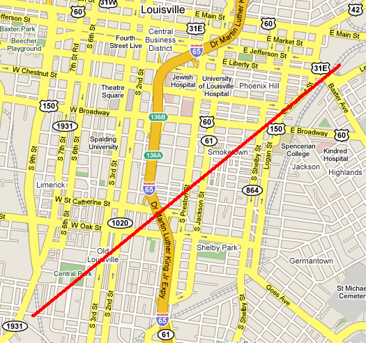
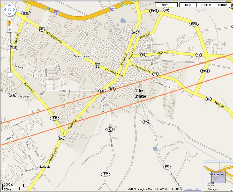
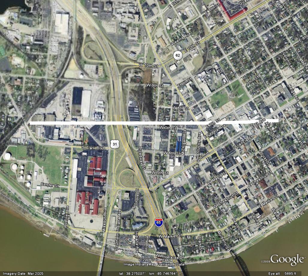
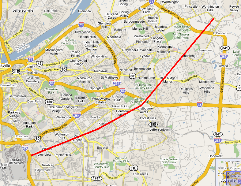