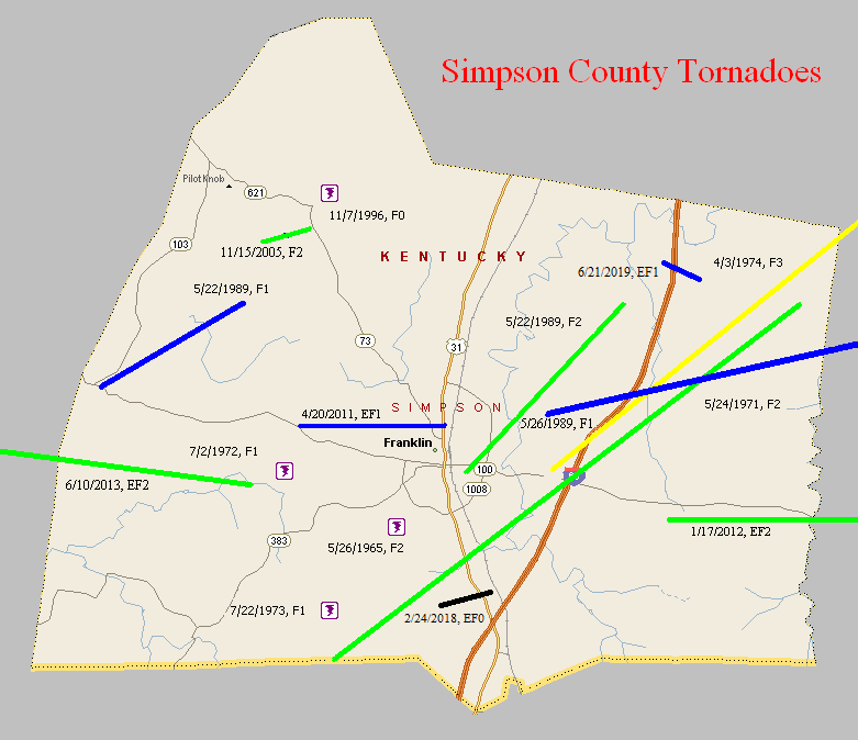
May 26, 1965
Counties: Simpson
F-scale: F2
Deaths:
Injuries:
Path width: 100 yards
Path length:
Time: 10:15pm
Noted discrepancies: SPC and NCDC list this as an F2...Grazulis does not list it. SPC gives a path length of 1/10 of a mile...NCDC gives nothing. SPC and Storm Data give a path width of 100 yards, NCDC gives nothing.
May 24, 1971
Counties: Simpson
F-scale: F2
Deaths:
Injuries:
Path width:
Path length:
Time: 5:35pm
Noted discrepancies: SPC/NCDC list this as an F2, Grazulis does not list it. Storm Data reports a plethora of seemingly significant damage.
July 2, 1972
Counties: Simpson
F-scale: F1
Deaths:
Injuries:
Path width:
Path length:
Time: 6:30pm
Noted discrepancies: None
July 22, 1973
Counties: Simpson
F-scale: F1
Deaths:
Injuries:
Path width:
Path length:
Time: 3:00pm
Noted discrepancies: SPC gives a path width of 10 yards, NCDC gives 30 yards.
April 3, 1974
Counties: Simpson, Warren, Barren
F-scale: F3
Deaths: 3
Injuries: 57
Path width:
Path length:
Time: 3:45pm
Grazulis narrative: Moved northeast from west of Gold City to east of Smiths Grove. One person was killed in Simpson County at Temperance as seven homes and 40 barns were destroyed. Two people died in Warren County: one at Three Forks and one at Rocky Springs.
Noted discrepancies: SPC, NCDC, and Grazulis give a time of 3:45pm...Storm Data says 4:45pm. SPC and NCDC give a path length of 31 miles...Grazulis says 25 miles. SPC gives a path width of 10 yards...NCDC 30 yards...Grazulis nothing.
May 22, 1989
Counties: Simpson
F-scale: F1
Deaths:
Injuries: 1
Path width:
Path length:
Time: 5:25pm
Notes: Storm Data says this tornado touched down in Middleton.
May 22, 1989
Counties: Simpson
F-scale: F2
Deaths: 0
Injuries: 0
Path width: 50 yards
Path length: 5 miles
Time: 6:50pm
Grazulis narrative: Eight homes and 22 barns were destroyed, and 13 other homes were damaged in the south part of Franklin.
Noted discrepancies: None
May 26, 1989
Counties: Simpson, Allen
F-scale: F1
Deaths:
Injuries:
Path width:
Path length:
Time: 3:27pm
Notes: Storm Data says this tornado did damage on Kinnard Road, passed Gold City, and ended one mile northeast of Mount Aerial (about two miles into Allen County). Using Storm Data information plus SPC's lift-off point work well for plotting this.
November 7, 1996
Counties: Simpson
F-scale: F0
Deaths:
Injuries:
Path width:
Path length:
Time: 12:55pm
Noted discrepancies: Storm Data puts this tornado near Stowers...but can't find a Stowers on any map.
November 15, 2005
Counties: Simpson
F-scale: F2
Deaths: 0
Injuries: 0
Path width: 150 yards
Path length: 1 mile
Time: 5:52pm
Notes: This tornado touched down near Pilot Knob. It damaged trailers and downed many trees. Minimal F2.
April 20, 2011
Counties: Simpson
EF-Scale: EF-1
Deaths: 0
Injuries: 0
Path width: 100 yards
Path length: 3.3 miles
Time: 1:30am CDT
Notes: The tornado moved from three and a half miles west of Franklin to the north side of town. Near KY 100 the twister destroyed a barn and threw debris about a quarter mile. The tornado then moved east damaging the roof of another barn and uprooting or snapping at least 100 trees.
January 17, 2012
Counties: Simpson, Allen
EF-Scale: EF-2
Deaths: 0
Injuries: 0
Path width: 150 yards
Path length: 9 miles
Time: 12:20pm CST
Notes: This tornado touched down near Hickory Flat Road just south of its intersection with Hickory Flat-Ridge Road in Simpson County where about a dozen trees were uprooted. The most significant damage occurred near the intersection of McKendree Church Road and Highway 100 where a well constructed brick house completely lost its roof. Multiple barns, garages, and outbuildings were destroyed here as well. Nearly a complete roof of one outbuilding was project 1/2 mile to the east. Another area of significant damage was at the intersection of Highway 100 and Reeder School Road (near the Simpson/Allen County line) where a house had significant roof damage and had an exterior wall blown out. A jeep in the driveway was blown into the house and a camper was blown from the driveway across the road with debris scattered through the field beyond. Damage continued east into Allen County with the last evidence of damage at Walker Chapel Road about a mile south of Highway 100.
June 10, 2013
Counties: Logan and Simpson
EF-Scale: EF2
Deaths: 0
Injuries: 4
Path width: 325 yards
Path length: 14 miles
Time: 1:40pm CDT
Notes: Touchdown occurred northwest of Adairville near the intersection of Vick Road and Route 96, where a barn sustained roof damage and another outbuilding was destroyed. EF2 damage occurred sporadically from near Route 96 to the Logan/Simpson county line. The worst damage occurred north-northeast of Adairsville where the tornado crossed Route 663. Several homes sustained extensive damage and three people were injured. A fourth person was injured on Trimble Road. The tornado entered Simpson County just north of the intersection of Conn Road and Reames Dixon Road. The tornado produced EF1 and EF0 damage in Simpson County until it lifted at Russellville-Gallatin Road at 2:09pm CDT. A total of five homes sustained extensive damage, and two homes suffered minor damage. Five grain bins were blown away, and two others collapsed. Numerous outbuildings were damaged or destroyed.
February 24, 2018
County: Simpson
EF-Scale: EF0
Deaths: 0
Injuries: 0
Path width: 100 yards
Path length: 1.7 miles
Time: 9:50pm - 9:52pm CST
Notes: The tornado began just southwest of Lake Spring Road where a couple of trees were snapped or uprooted and a 24 x 36 barn experienced extensive roof panel damage. The tornado crossed farmland and then struck another barn near the intersection with US 31W. Metal sheeting was thrown from the barn in various directions and much of it ended up in the trees. There were a few twisted trees on both sides of the highway and the tornado lifted just to the northeast of the road.
June 21, 2019
County: Simpson
EF-Scale: EF1
Deaths: 0
Injuries: 0
Path width: 75 yards
Path length: 0.6 mile
Time: 7:35pm CDT
Notes: The tornado touched down near I-65 embedded in straight line winds. The tornado hit the Salem Rd area hard with extensive tree damage. A wheat field had distinct circulations quite visible.


 Weather Story
 Weather Map
 Local Radar