
A cold front pressing east across the central U.S. will be the focus for areas of strong to severe thunderstorms and excessive rainfall through this weekend. Strong to severe thunderstorms my bring damaging winds, hail, and a few tornadoes while excessive rainfall may lead to areas of flooding. Heat will build across the western U.S. with heat-related watches, warnings, and advisories issued. Read More >
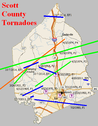
April 30, 1852
Counties: Scott KY
F-scale:
Deaths:
Injuries:
Path width:
Path length:
Time:
Narrative: A possible tornado hit four miles north of Georgetown.
March 24, 1921
Counties: Scott KY
F-scale: F2
Deaths: 0
Injuries: 0
Path width:
Path length: 5 miles
Time:
Notes: This tornado touched down near Watkinsville and moved northeast. Barns, power poles, and trees were immediately blown down. Some trees were uprooted and blown 20 feet. Additional barns were destroyed on the Wiley and Bramlett farms. The tornado quickly grew to 3/4 of a mile wide, and uprooted an entire orchard (nearly 100 trees) on the Green Farm west of Stamping Ground. A chicken house was blown away, killing 92 of the 100 chickens within. The Cook Farm suffered two destroyed barns and a badly damaged house. As the tornado neared Stamping Ground, it narrowed to 1/4 mile wide, and then lifted just northeast of town. W. A. Mitchell of the Lexington Weather Bureau office felt that the damage was straight-line winds (why he felt this way is unknown, and this project will instead agree with Grazulis that this was a true tornado). The tornado may have dipped very briefly to earth again on or near Cincinnati Road south of Double Culvert, though no specific damage reports have been found from that area. Witnesses described a "funnel-shaped cloud whirling along at high speed" that "sounded like a train coming across a railroad trestle" with debris circulating the funnel. Near the tornado's touchdown point the twister was followed by hail that greatly damaged fruit trees.
November 20, 1950
Counties: Scott, KY
F-scale: F1
Deaths: 0
Injuries: 0
Path width: 100 yards
Path length: 5 miles
Time: 4:00am
Notes: A strong thunderstorm passed through Georgetown in the pre-dawn hours. Wind damage was spread across about a six mile wide swath south through east of town, with a small tornado embedded within. The actual tornado probably touched down just west of Lexington Road about 3/4 of a mile northwest of the Fayette County line. It traveled to the northeast across Lemons Mill Road and then to the north-northeast along Crumbaugh Road, across Paris Pike, and up Old Oxford Road, dissipating before reaching Cynthiana Road. The first places hit were the Anderson Farm about three miles south of Georgetown, where a cabin lost its roof, the Showalters Farm just south of there, and Julia Marcum's place next door to the Showalters. Julia's barn's roof was blown into Georgetown Cemetery. Then the barn of T. P. Pickett was unroofed on Lemons Mill Road. On Lemons Mill Pike the John Drake Farm and the home of Dr. S. S. Amerson were hit. Turning more towards the north, the roof of a barn on Crumbaugh Road owned by C. A. Thornton was blown off. The Earl Watson farm was damaged as the tornado crossed Paris Pike. The worst damage of the event occurred just before the tornado dissipated, when it removed the roof and broke the windows of a home owned by Lewis Oliver on Old Oxford Road. The house was built in 1777 (this project wonders if it was the Charles Whitaker House). After then damaging the Hixson Farm, the twister dissipated. One resident on Oxford Pike said, "The noise of the twister was worse than the noise of a train passing near you." Trees were uprooted all along the tornado's path. Nearby straight-line wind damage in Georgetown was comparatively light. A barn was slightly damaged in the South Hudson neighborhood, a barn was damaged on Fountain Avenue, and the home of Sheriff Deputy Murphy on Clayton Avenue lost its two chimneys and suffered other roof damage as well.
Noted discrepancies: SPC and NCDC call this an F1, Grazulis calls it an F2. SPC gives a path length of 1/10 of a mile, NCDC provides no length, and Grazulis gives a length of 5 miles. SPC gives a width of 10 yards, NCDC provides no width, and Grazulis gives 100 yards. Grazulis' path length and width are probably more correct.
June 12, 1964
Counties: Scott KY
F-scale: F1
Deaths:
Injuries: 2
Path width:
Path length:
Time: 3:30pm
Noted discrepancies: None.
June 15, 1964
Counties: Scott KY, Harrison KY, Nicholas (and Fleming)
F-scale: F2
Deaths: 0
Injuries: 0
Path width: 30 yards
Path length: 49 miles
Time: 2:30pm
Grazulis narrative: Moved east, destroying barns and badly damaging two farm houses near Turkey Foot. This was one of a family of small tornado that skipped across three counties.
Noted discrepancies: At NCDC Scott County is listed twice and Harrison and Nicholas counties are not included. Storm Data only mentions Scott, Harrison, and Fleming counties (which doesn't make sense since Nicholas County is between Harrison and Fleming counties). The end lat/lon in the first NCDC Scott County entry is the same as the begin lat/lon in the second Scott County entry. Grazulis lists only Scott County...he does not specifically list Harrison or Nicholas...though he does mention that his Scott County tornado was "one of a family of small tornadoes that skipped across three counties" and he does mention Fleming County as being one of those three. SPC gives an ending lat/lon of 38.42/-83.73...NCDC gives 38.40/-83.93. SPC and NCDC give a path length of 49 miles, Grazulis gives one mile, Storm Data says 50 miles. SPC gives a path width of 10 yards, NCDC 30 yards, Grazulis gives nothing. Storm Data says the tornado touched down near Skinnersburg in Scott County, then lifted and touched down again at Turkey Foot in Scott County..."apparently across Harrison County", and then did damage near Flemingsburg. Should probably plot as one coherent tornado from Skinnersburg to Fleming, including all counties in between (and avoiding Bourbon County)
April 23, 1970
Counties: Scott KY
F-scale: F3
Deaths: 0
Injuries: 0
Path width: 50 yards
Path length: 1/2 mile
Time: 4:20am
Grazulis narrative: At Great Crossing, four miles west of Georgetown, a small tornado destroyed a home. Another home was badly damaged, and several barns and outbuildings were blown down.
Noted discrepancies: SPC and NCDC rank this as an F3...Grazulis gives it an F2.
April 3, 1974
Counties: Anderson, Franklin, Scott KY
F-scale: F4
Deaths: 4
Injuries: 122
Path width: 800 yards
Path length:
Time: 4:50pm
Grazulis narrative: Moved northeast near Alton, passing along the south and southeast edge of Frankfort, where homes were leveled and four people were killed. About 120 homes were damaged or destroyed near Frankfort, as were businesses and factories. Twelve homes were destroyed near Alton. The funnel passed near Stamping Ground and lifted near Sadieville.
Noted discrepancies: NCDC does not give a liftoff lat/lon. SPC gives a path length of 79 miles...NCDC gives 81 miles (including 54 miles in Scott County, which is impossible), and Grazulis gives 36 miles. NCDC/SPC start this tornado on the western Anderson County line west of Gee...Grazulis starts it in Anderson County but farther east at Alton. SPC gives a path width of 10 yards, NCDC 30 yards, Grazulis 800 yards. Grazulis probably has the most correct path width. For this mapping project we used the official start/stop lat/lons, but further research is needed to verify. (The ending lat/lon given by NCDC for the Franklin County portion of the track is wrong.)
April 3, 1974
Counties: Scott KY
F-scale: F2
Deaths: 0
Injuries: 20
Path width:
Path length:
Time: 7:15pm
Grazulis narrative: Moved east-northeast from five miles southeast of Stamping Ground to Muddy Ford. There were 134 "uninhabitable" homes.
Noted discrepancies: SPC and NCDC list a path length of 10 miles, Grazulis says 14 miles. SPC gives a path width of 10 yards, NCDC 30 yards, Grazulis nothing. Grazulis lists this tornado at 8:15pm.
June 29, 1979
Counties: Franklin, Scott KY, Harrison KY
F-scale: F2
Deaths:
Injuries: 7
Path width:
Path length:
Time: 6:00pm
Noted discrepancies: SPC and NCDC list this as an F2, Grazulis does not list it. NCDC's county-by-county lat/lons result in a very strange path. Will use more logical SPC lat/lons for plotting. Storm Data has this tornado touch down four miles north of Frankfort and moves it to Georgetown and near Cynthiana. Further research would be good, to confirm this tornado's track.
July 12, 1979
Counties: Scott KY
F-scale: F1
Deaths:
Injuries:
Path width:
Path length:
Time: 2:30pm
Notes: Storm Data touches this tornado down on "Lemon Hill Road" near Georgetown...it seems this should be "Lemons Mill Road".
July 2, 1980
Counties: Scott KY, Fayette
F-scale: F1
Deaths: 0
Injuries: 0
Path width: 300 yards
Path length: 13 miles (skipping)
Time: 6:55pm
Noted discrepancies: SPC gives a path width of 10 yards, NCDC 30 yards, Storm Data 300 yards. The details concerning this tornado are somewhat murky, but it appears that it touched down southwest of Georgetown where it damaged a greenhouse, and skipped to the east into far northern Fayette County. The Lexington Leader mentions the tornado north of the city but doesn't say anything about any damage. Rather, the paper instead describes damage in Lexington in a southwest-northeast path from Collier Court through Balmoral Court to the intersection of Bryanwood Parkway and Bellcastle Road. It's possible that this was a very small weak tornado, but knowing that for certain is virtually impossible this far after the event. The newspaper also mentions light damage on Nantucket Drive and Melbourne Way in the southwest part of the city, and a tree that was blown down somewhere on Emerson Drive.
April 20, 2011
Counties: Scott KY
EF-Scale: EF-1
Deaths: 0
Injuries: 0
Path width: 50 yards
Path length: 0.5 mile
Time: 1:54am EDT
Notes: This tornado struck about seven miles northeast of Georgetown. A tied-down trailer was overturned. Several outbuildings were destroyed or damaged. A garage wall of a well-built home buckled.
January 17, 2012
County: Scott KY
EF-Scale: EF-1
Deaths: 0
Injuries: 0
Path width: 75 yards
Path length: 0.5 mile
Time: 12:12pm EST
Notes: This tornado touched down at 338 Soards Road and moved northeast, lifting as it began to cross a small lake. A well-anchored 50x20 three bay barn was destroyed and scattered in three directions. A 20x30 barn was also destroyed, and a third small barn along the path was damaged. Numerous trees were blown down, snapped, or uprooted. Fences were torn down as well. This survey was conducted by personnel from both the NWS and emergency management from Franklin and Scott Counties
October 7, 2014
County: Scott, KY (from Owen)
EF-Scale: EF1
Deaths: 0
Injuries: 0
Path width: 150 yards
Path length: 4.1 miles
Time: 3:45pm - 3:50pm EDT
Notes: Most of the damage was to trees. The only structural damage was to a small home on the top of a hill near South Rays Fork Road. The porch roof was ripped from the home and thrown over the building, there was significant roof damage, and an above-ground pool was destroyed.
October 7, 2014
County: Scott, KY
EF-Scale: EF1
Deaths: 0
Injuries: 0
Path width: 150 yards
Path length: 2 miles
Time: 3:48pm - 3:49pm EDT
Notes: This tornado caused minor damage to the roofs of two houses and significant damage to the roof of another house. A small outbuilding was also destroyed.
October 7, 2014
County: Scott, KY
EF-Scale: EF1
Deaths: 0
Injuries: 0
Path width: 150 yards
Path length: 3.6 miles
Time: 3:50pm - 3:52pm EDT
Notes: Mostly tree damage occurred with this tornado. Near the end of its path two small barns were destroyed and two homes sustained roof damage.


 Weather Story
 Weather Map
 Local Radar