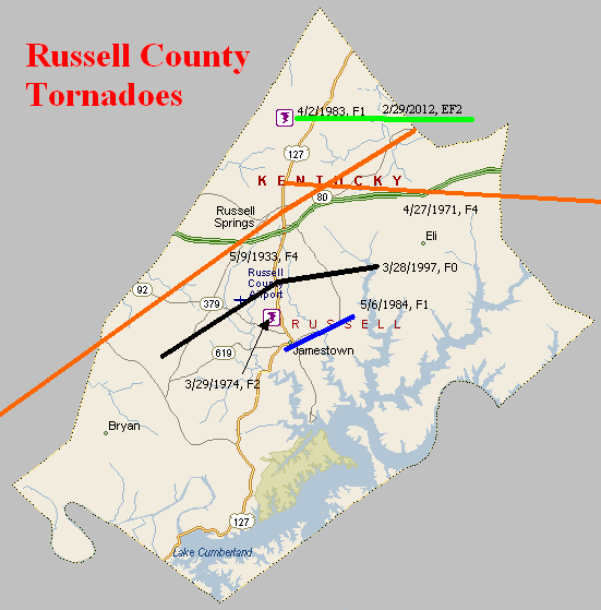
May 9, 1933
Counties: Monroe, Cumberland, Adair, Russell
F-scale: F4
Deaths: 36
Injuries: 87
Path width: 800 yards
Path length: 60 miles (probably a family of tornadoes)
Time: 8:30pm
Notes: This historic event began around 8pm when there was 30 minutes of rain and hail in Tompkinsville, followed by five minutes of absolute calm. The calm was shattered when a tornado touched down just southwest of town and moved northeast, directly into southern sections the city (the "Negro section," as newspapers called it at the time). The path of utter destruction, in which everything was flattened, was a quarter mile wide. The damaged residences of O. C. Landrum and Oscar Sims marked the edges of the devastation. Between them was a treeless and fenceless waste, with scattered remnants of homes and uprooted trees. A heavy rain, which fell continuously from 1 o'clock until 6 the following morning, made roads almost impassable and handicapped the work of rehabilitation. Only three homes that were affected by the funnel were able to be salvaged. World War I veterans described the devastation and suffering as worse than what they witnessed during the Great War. The twisting nature of the winds was clearly revealed when the bodies of the Tyree family were found 75 yards south of their home site, and the bodies of the Redeford family were discovered 100 yards north of the spot where their home had stood. The Tyrees lived on the southern edge of the storm area, while the Redefords lived near the northern edge. The body of the Rev. Redeford's wife was carried 150 yards to a pond on the land belonging to L. P. Hagan. The corpse of the husband was found entangled in a barbed wire fence, having been blown about one hundred yards. Sixteen people in Tompkinsville lost their lives that evening, with another 2 deaths just northeast of town in Sewell. Fifty citizens were injured in Monroe County. After Tompkinsville, the tornado continued to the northeast, crossing Cumberland County (2 people injured) and clipping the southeast corner of Adair County (2 people killed in the Cundiff area) with comparatively little damage, before intensifying again as it entered Russell County. The tornado grew into a mile-wide monster as it plowed down at least 100 homes. The edge of the tornado missed downtown Russell Springs by only half a mile. The tornado spent its last fury in the Happy Acre area, causing damage along Goose Creek, near Friendship Church, and on the southern end of Bethany Ridge where chickens were stripped of their feathers. The tornado lifted at the Casey County line. Fatality counts for Russell County vary from 14 to 20 depending on the source...this study will use Grazulis' number of 18. Of those 18, 14 were killed on the southeast edge of Russell Springs. Up to 100 people may have been injured in Russell County.
April 27, 1971
Counties: Russell (to Pulaski)
F-scale: F4
Deaths: 2 (Mr and Mrs Bulon Swanson)
Injuries: 72 (70 in Russell County, 2 in Pulaski County)
Path width: 100 yards
Path length: 14 miles
Time: 10:53pm
Grazulis narrative: Moved east from east of Russell Springs, to Salem, and to Faubush. At Gosser Ridge two people were killed on a farm as most of the buildings were swept away. Along the path, 35 homes, four trailers, 60 barns, and 79 other buildings were destroyed. There was major damage to 105 more homes. The Salem School was damaged. At one point, there were two distinct paths, as two funnels moved parallel to one another. See this YouTube video.
Noted discrepancies: SPC and NCDC give a path length of 13 miles, Storm Data and Grazulis give 14. SPC, NCDC, and Storm Data give a path width of 100 yards, Grazulis give 200 yards. According to Storm Data this tornado touched down two miles north of Russell Springs (Grazulis starts it east of Russell Springs).
March 29, 1974
Counties: Russell
F-scale: F2
Deaths:
Injuries: 1
Path width:
Path length:
Time: 9:00pm
Grazulis narrative: A tornado destroyed two trailers and a barn, just north of Jamestown.
Noted discrepancies: SPC and NCDC give a time of 9:00pm, Grazulis and Storm Data five 10:00pm.
April 3, 1974
Counties: Russell (to Pulaski, Rockcastle)
F-scale: F3
Deaths:
Injuries:
Path width:
Path length:
Time: 10:30pm
Noted discrepancies: NWS ranks this as an F3, but Grazulis does not list it. NCDC lists only Pulaski and Rockcastle counties. SPC lists only Pulaski County lat/lons. SPC lists a path width of 10 yards, NCDC 30 yards. The SPC/NCDC touchdown lat/lon is just barely inside Pulaski County. Storm Data moves this tornado from near Mount Victory, which is nowhere near the lat/lons given for Pulaski County, then along the Laurel/Rockcastle county line (but listing only Rockcastle County). This tornado is unplottable, pending further research.
April 2, 1983
Counties: Russell
F-scale: F1
Deaths:
Injuries: 1
Path width:
Path length:
Time: 9:35am
Noted discrepancies: None
May 6, 1984
Counties: Russell
F-scale: F1
Deaths:
Injuries:
Path width:
Path length:
Time: 1:00am
Noted discrepancies: None.
March 28, 1997
Counties: Russell
F-scale: F0
Deaths:
Injuries:
Path width:
Path length:
Time: 7:50pm
Notes: Storm Data touched this tornado down near KY 55 and hits Middletown and Half Acre.
February 29, 2012
County: Russell, Casey
EF-Scale: EF-2
Deaths: 0
Injuries: 0
Path width: 150 yards
Path length: 7.2 miles
Time: 1:22pm CST
Notes: The tornado first touched down north of Russell Springs in northern Russell County west of Highway 127 where it did minor damage to trees, barns, and outbuildings. The tornado then intensified as it moved east with the worst damage occurring along a 1.5 mile stretch from Highway 76 east over Oak Grove Road to Pattie Ridge Road. On Highway 76, two mobile homes were totally destroyed and a modular home was rotated 30-80 feet counterclockwise off its foundation (with a quarter of the home blown away). Two residents survived in an underground tornado shelter where they took refuge having heard of the warning via sirens and phone calls 3-5 minutes before the tornado destroyed their homes. Residents were not home at the time of the tornado at the other homes destroyed along its path. The tornado then weakened as it moved into southern Casey County where it damaged more trees, barns, and outbuildings. The tornado finally lifted west-southwest of Windsor leaving a 7.2 mile track.


 Weather Story
 Weather Map
 Local Radar