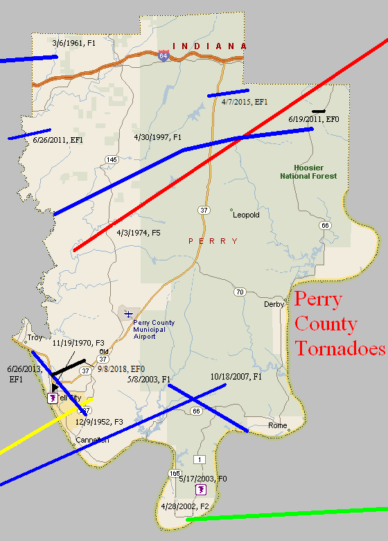
December 9, 1952
Counties: Hancock, Perry (from Daviess)
F-scale: F3
Deaths: 0
Injuries: 3
Path width: 880 yards
Path length: 32 miles
Time: 3:00pm
Grazulis Narrative: Moved northeast, striking the northern part of Tell City. There were three homes destroyed in Kentucky, and $200,000 damage. Many barns were destroyed in Indiana, where there was $300,000 damage. Most of the Indiana damage was from wind-driven hail.
Noted discrepancies: SPC and NCDC call this an F3, Grazulis an F2. SPC and NCDC give a time of 3:00pm, Grazulis 2:30pm. SPC gives a path length of 70 miles, NCDC gives 35 miles, Grazulis gives 32 miles. SPC gives a path width of 880 yards, NCDC gives 30 yards, Grazulis says 400 yards. Grazulis mentions this was probably a family of tornadoes. NCDC or Grazulis must have the better path length...SPC entry looks to be an entry error. Storm Data says the tornado crossed from Kentucky into Indiana at Tell City with a "total path length in both states" of 32 miles.
November 19, 1970
Counties: Perry IN
F-scale: F3
Deaths:
Injuries:
Path width:
Path length:
Time: 10:47pm
Noted discrepancies: SPC and NCDC rank this as an F3...Grazulis does not list it. The worst damage mentioned in Storm Data is the destruction of a barn and three farm buildings, along with scattered roof damage and a "wrecked" trailer.
Notes: According to Storm Data the tornado touched down on the southwest side of IN 66 at the west edge of Tell City. The storm crossed IN 66 into a cemetery and trailer court.
April 3, 1974
Counties: Perry, Crawford, Harrison IN, Washington IN, Clark IN, Scott IN
F-scale: F5
Deaths: 6
Injuries: 76
Path width:
Path length:
Time: 1:20pm
Grazulis narrative: Moved east-northeast and northeast from three miles south of Huffman, passing southeast of Branchville, north of Sulphur Springs and Pilot Knob, south of Sulphur and Curby, across the southeast part of DePauw, hitting two miles east of Palmyra, passing through Martinsburg, crossing the southeast half of Daisy Hill, passing between Bunker Hill and New Liberty, and ending two miles north of IN 160. This tornado immediately killed a woman as it destroyed her mobile home. As the tornado passed along southeast of Branchville it killed again. Two people, riding in a school bus, saw the tornado and took shelter in a nearby ditch. The bus was thrown fifty feet into the ditch, crushing the couple and killing the woman. Moving across Crawford County, the tornado widened to over a mile, missing many small communities and levelling several farms. In Harrison County the tornado killed a woman in her mobile home in southeast Depauw. Another woman was killed in her home two miles east of Palmyra. In the southeastern corner of Washington County the tornado struck the town of Martinsburg, destroying 38 of the town's 48 homes. Homes in the Daisy Hill area were completely swept away.
Noted discrepancies: SPC and Grazulis list 6 deaths for this tornado, NCDC lists 5. SPC lists 86 injuries, NCDC 53, Grazulis 76, Storm Data 95. SPC lists a path length of 68 miles, NCDC 50 miles, Grazulis 62 miles, Storm Data 67 miles. SPC gives a path width of 10 yards (obviously incorrect), NCDC 30 yards (obviously incorrect), Grazulis 1760 yards, Storm Data 700 yards. This tornado is split into two tornadoes at SPC. Grazulis lists an incorrect ending point for the tornado. Storm Data begins this tornado between Huffman and Tarry in Perry County and lifts it a few miles northeast of Lexington in Scott County. SPC lat/lon ends the tornado southwest of Lexington, rather than northeast. It's been mapped here according to the information in Storm Data, but additional research would be helpful.
April 30, 1997
Counties: Perry
F-scale: F1
Deaths:
Injuries:
Path width:
Path length:
Time: 8:00pm
Notes: Storm Data says the hardest hit areas were Apalona and Branchville.
April 28, 2002
Counties: Perry, Breckinridge, Meade
F-scale: F2
Deaths:
Injuries: 7
Path width:
Path length:
Time: 2:05am
Noted discrepancies: SPC lists a path width of 50 yards, NCDC and Storm Data list 150 yards. Storm Data takes this tornado from 3/10 of a mile southwest of Tobinsport to 1.8 miles east northeast of Tobinsport. Storm Data mentions that this tornado crossed into Kentucky from Perry County...hitting Irvington, two miles east northeast of Cloverport, and two and a half miles south of Garrett.
May 8, 2003
Counties: Perry
F-scale: F1
Deaths:
Injuries:
Path width:
Path length:
Time: 7:45pm
Notes: Storm Data takes this tornado from five miles southwest of Gerald to 2.4 miles west of Rome in Hoosier National Forest.
May 17, 2003
Counties: Perry
F-scale: F0
Deaths:
Injuries:
Path width:
Path length:
Time: 3:47am
Notes: Storm Data places this tornado about five and a half miles southwest of Rome in Hoosier National Forest.
October 18, 2007
Counties: Hancock, Perry
EF-scale: EF1
Deaths: 0
Injuries: 0
Path width: 220 yards
Path length: 14 miles (skipping)
Time: 6:18pm CDT to 6:45pm CDT
Notes: This tornado touched down along the Daviess County line near Gatewood and did primarily tree and power line damage as it headed northeast. The tornado lifted slightly and passed over Hawesville as a funnel cloud (though 75 mph winds still did damage in town). The tornado came back to earth just on the other side of Cannelton and proceeded northeast into the Hoosier National Forest, damaging the Girl Scout Camp on Cann Heights Road and lifting at Plock Knob.
June 19, 2011
Counties: Perry
EF-Scale: EF-0
Deaths: 0
Injuries: 0
Path width: 70 yards
Path length: 0.2 mile
Time: 6:31am CDT
Notes: Ten trees were uprooted, blown over, or snapped on either side of Route 66 north of Oriole.
June 26, 2011
Counties: Perry (from Spencer)
EF-Scale: EF-1
Deaths: 0
Injuries: 0
Path width: 200 yards
Path length: 2.3 miles
Time: 2:12am CDT
Notes: A tornado touched down 0.7 miles south of St. Meinrad in Spencer County on the southern end of the St. Meinrad Seminary grounds. It destroyed a cinder block outbuilding and took a 100 foot section of roofing off of a large metal outbuilding. The tornado also uprooted numerous trees and ripped off sections of roofing from several other buildings. The tornado weakened as it moved into forested hills where it snapped and uprooted several trees along a narrowing path. The tornado lifted near Catnip Road in Perry County which is about 2.3 miles east of St. Meinrad.
June 26, 2013
County: Perry
EF-Scale:EF1
Deaths: 0
Injuries: 0
Path width: 100 yards
Path length: 5.2 miles
Time: 8:29pm CDT
Notes: This tornado touched down southeast of Troy and moved southeast through the east side of Tell City. Several large trees were felled and there was some minor roof damage and damage to outbuildings. A large semi trailer and a few rides were blown sideways at a carnival at 10th & Watt streets.
April 7, 2015
County: Perry
EF-Scale: EF1
Deaths: 0
Injuries: 0
Path width: 100 yards
Path length: 2.6 miles
Time: 4:27pm - 4:30pm EDT
Notes: The tornado touched down just east of Lake Celina where one tree was uprooted and others were snapped. The tornado then continued east across IN-37 where it uprooted and snapped several dozen trees along Old IN-37. The damage continued east towards Ottoman Road where a carport was destroyed, along with additional trees that were snapped and uprooted. From there, the tornado took a jog to the northeast across Orchid and St. Croix Roads where it caused substantial tree damage, uprooting and/or snapping trunks 15-20 feet high on approximately 100 trees. The tornado then lifted just east of Saint Croix Road.
September 8, 2018
County: Perry
EF-Scale: EF0
Deaths: 0
Injuries: 0
Path width: 80 yards
Path length: 1.8 miles
Time: 2:38pm - 2:44pm EDT
Notes: The tornado touched down on Main Street in Tell City, midway between Steuben and Winkelreid Streets, doing minor damage to one roof and bending an amateur radio antenna tower. Moving east-northeast, the tornado damaged roofs and snapped several large tree limbs, as well as toppling a large but rotting tree that crushed the roof of a garage. A small shed was lofted out of its yard and became entangled in utility lines 30 yards to the northeast. As it crossed Winkelreid Street between 10th and 11th Streets, it buckled in a large overhead door and caused minor damage to the roof of the Indiana Southern Power building. Continuing to the northeast, a large metal carport was lifted and blown 50 feet north into neighboring trees, and more tree limbs were snapped, while a vinyl fence was blown northwest, as was a large trampoline and a patio umbrella, which was entangled in utility lines northwest of its origin. The tornado continued to cause tree damage as it moved east of 14th Street into a more rural area. On Brushy Fork Rd, the tornado snapped the trunks of three large trees, then continued northeast into a wooded area. The last evidence of the tornado was at the north end of Quaker Rd, where small branches were broken.


 Weather Story
 Weather Map
 Local Radar