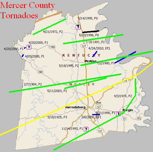
February 7, 1904
Counties: Washington, Mercer
F-scale: F2
Deaths: 0
Injuries: 11
Path width:
Path length: 15 miles
Time: 3:00am
Narrative: Moved east from ten miles west of Harrodsburg. The worst damage was at Cornishville, where seven homes, a church, and a bridge were destroyed. Other barns and homes were unroofed.
March 18, 1925
Counties: Marion, Washington KY, Mercer, Jessamine, Fayette, Bourbon
F-scale: F3
Deaths: 2
Injuries: 40
Path width: 300 yards
Path length: 60 miles (skipping)
Time: 6:30pm
Notes: What was almost certainly a family of tornadoes moved northeast from western Marion County (according to Grazulis) to 4 miles southwest of Paris in Bourbon County. This project has so far been unable to find any damage in Marion or Jessamine Counties. In Washington County many buildings across the county were leveled. The country home of Judge Case near Springfield was unroofed. The "Negro section" of Jimtown was destroyed, and all 25 houses in Jimtown were razed after the storm. In Springfield 30 people were injured and 2 were killed (the two fatalities may have been from Jimtown). Moving into Mercer County, two barns were lost on the Bond Farm. A barn was damaged and a house unroofed on the Terhune Farm, barns were blown down on the Quartz and Shelton Farms, a house and a barn were lost on the Sanford Farm, and the home of Kye Crossfield at Ebenezer was destroyed. The tornado was 1/4 mile wide in Mercer County. After possibly weakening or lifting in Jessamine County, the tornado slammed into eastern sections of Fayette County with renewed vigor. Trees were blown down on Chilesburg Road, and many trees and fences were torn down on the John E. Madden Farm on Winchester Road about four miles out of Lexington (roughly where Winchester Road meets I-75 today). The tornado reached its peak strength, high-end F3 (possibly F4) over a four-mile stretch of eastern Fayette County. About five and a half miles from Lexington on Briar Hill Road the twister devastated the Kelley Farm. Mrs. Kelley's 40-year-old "Negro hired hand" was blown 300 yards to his death. Nearly every bone in his body was broken. His right hip was dislocated to the point where it was alongside his chest. No trace of his cabin was ever found. The two-story eight-room main residence was "torn from its foundations" and reduced to a pile of rubble. The farm's chickens were stripped of their feathers. According to witnesses, the tornado was "cone-shaped and had a large black cloud at its top, coming out of the west. A pillar of flame shot skyward when the vortex of the twister struck the Kelley residence." Trees and telephone poles were blown down for a mile along Briar Hill Road. The Jonas Weil Farm on Briar Hill Road suffered an unroofed home, two miles of destroyed fence, and 500 felled trees. Moving along to the northeast, the Muir area was next in line (near the intersection of KY 1970 and KY 1973 today). William Johnson's residence on Muir Pike was "piled upon its foundations and partly blown away." The Deaver Farm was damaged, and a 15 pound rock was blown through a wall like a cannonball. Many trees were blown down. Proceeding into Bourbon County, the house of Rodes Donald had two rooms blown away, the Dudley School was moved four feet off its foundation, fifty trees were blown down on the Ewing Farm, and the Spears Farm on Stewart Road was damaged. The tornado then finally began to weaken and it dissipated about four miles shy of Paris.
April 21, 1972
Counties: Mercer
F-scale: F2
Deaths:
Injuries:
Path width:
Path length:
Time: 10:10pm
Grazulis narrative: Moved northeast from six miles west of Salvisa to one mile east of Ballard. Five barns were destroyed, two of which had concrete foundations. A house and a metal silo were destroyed. Two cars and a truck were destroyed, and a 400-gallon water tank was moved three-quarters of a mile. A 16-inch rafter was driven into the ground.
Noted discrepancies: Grazulis lists this tornado at 11:10pm. SPC/NCDC stop this tornado at Salvisa, but Grazulis takes it into Anderson County, ending it one mile east of Ballard. In Storm Data the tornado touched down six miles west of Salvisa in Mercer County (one mile east of Ballard) and moved northeast along Stratton Road, Kirkwood Road, Gash Road, and Hickory Grove Road, all of which are in Mercer County. At this point, prefer to plot this tornado only in Mercer County.
April 3, 1974
Counties: Boyle, Mercer
F-scale: F2
Deaths: 0
Injuries: 10
Path width:
Path length: 16 miles
Time: 6:12pm
Grazulis narrative: Moved north-northeast from five miles west of Danville to the east side of Pleasant Hill, passing two miles east of Harrodsburg and ending about eight miles northeast of that town. Ten people were injured in rural Boyle County. In Mercer County four homes and 26 homes were destroyed. Thirty-four homes were damaged.
Noted discrepancies: NCDC gives no liftoff lat/lon. SPC gives a path length of 16 miles, NCDC 17 miles, Grazulis 18 miles. SPC gives a path width of 10 yards, NCDC 30 yards, Grazulis nothing.
Notes: Storm Data begins this tornado near Nevada, moving it to the east side of Burgin, then curving northward to 3/4 of a mile west of Dix Dam, to the east side of Pleasant Hill.
July 2, 1980
Counties: Mercer, Woodford
F-scale: F1
Deaths:
Injuries: 1
Path width:
Path length:
Time: 7:30pm
Noted discrepancies: Storm Data also includes Jessamine County, but mentions no specific damage.
May 21, 1990
Counties: Mercer
F-scale: F1
Deaths:
Injuries:
Path width:
Path length:
Time: 4:15pm
Noted discrepancies: None
November 14, 1993
Counties: Mercer
F-scale: F1
Deaths:
Injuries:
Path width:
Path length:
Time: 8:31am
Notes: Storm Data says this tornado touched down three miles south of Harrodsburg.
May 14, 1995
Counties: Mercer
F-scale: F0
Deaths:
Injuries:
Path width:
Path length:
Time: 1:55am
Noted discrepancies: NCDC and Storm Data give no F-scale rating for this tornado.
Notes: Storm Data puts this tornado at Salvisa.
Grazulis lists an F2 tornado in Woodford County with eight injuries, a path length of one mile, and a path width of 200 yards on May 18, 1995 at 6:35am. His narrative: "A trained spotter saw a tornado near Salvisa. Cars were blown upside-down and homes were demolished." Neither SPC nor NCDC list this tornado. Wonder if it could actually be the following events? Salvisa is in Mercer County, not Woodford.
May 18, 1995
Counties: Mercer, Woodford
F-scale: F2
Deaths: 0
Injuries: 8
Path width: 125 yards
Path length: 10 miles
Time: 7:16am-7:28am EDT
Notes from investigation in 2017: Several homes were damaged and trees uprooted as the tornado touched down. On the north side of Salvisa there was roof damage to barns and sheds along with extensive tree damage. On US 127 cars were blown off the road and damaged. Trees and power poles were snapped between Oregon and Ebenezer. Tree damage occurred near Nonesuch with F1 strength winds in southern Woodford County.
Noted discrepancies: SPC and NCDC list this as an F2, but Grazulis does not list it (which it should be, regardless of strength, as was his practice in his 1992-1995 supplement...lending support to the theory that this tornado is listed in Grazulis as the Woodford County event.) The lat/lon given for this tornado agrees with the location Grazulis gives: Salvisa, which is in Mercer County, not Woodford. Storm Data mentions the tornado location as Salvisa, but lists it under Woodford County, at 7:45am, with 6 injuries.
May 18, 1995
Counties: Mercer, Woodford, Jessamine, Fayette
F-scale: F2
Deaths: 0
Injuries: 30
Path width: 350 yards
Path length: 24 miles
Time: 7:19am-7:46am EDT
Notes from investigation in 2017: In McAfee several homes had uplifted roofs, a chimney was destroyed, and garage doors collapsed. Barns and outbuildings were destroyed. Several cars were blown off US 127, resulting in injuries. The tornado crossed into southern Woodford County just north of Mundys Landing. It damaged or destroyed eight homes with several injuries. In southwest Jessamine County at the intersection of KY 1268 and US 68 seven horses were killed along with extensive barn and fence damage. West Jessamine High School was hit around 7:36am when the tornadic wind speeds were around 145mph. Extensive structural damage was done to the school, amounting to a cost of two million dollars. There were at least 20 injuries, one critical. The tornado struck as students were arriving at school on buses. Eleven buses suffered damage and had their windows blown out. The high school roof was lifted and some top floor exterior walls collapsed. The school's tobacco barn and greenhouse were destroyed and the cattle barn was damaged. The tornado then hit a strip mall and Wal-Mart producing roof uplift and sign damage. Numerous pallets loaded with mulch and topsoil were thrown or shifted several yards. Across the county numerous power poles, barns, and homes sustained damage. The tornado weakened to F1 strength as it moved into the Tates Creek Trailer Park on the Fayette County line. There was complete destruction of roofs and walls of several single and double wide trailers. As the tornado lifted at Coletown several trees fell or were snapped.
Grazulis narrative: A tornado touched down near US 127 and moved northeast. Three houses were destroyed and five were damaged. Barns were blown down along KY 1160 near McAfee. There were also two cars damaged and eight minor injuries. A car was tossed several hundred yards.
Noted discrepancies: Grazulis times this at 6:35am. NCDC gives no beginning or ending locations for this tornado. SPC gives one point, just northeast of KY 390 northwest of Bohon.
May 13, 1998
Counties: Mercer
F-scale: F0
Deaths:
Injuries:
Path width:
Path length:
Time: Noon
Noted discrepancies: SPC lists a path width of 30 yards, NCDC says 20 yards.
Notes: Storm Data takes this tornado on a two mile long path along Gilberts Creek from Salvisa to two miles east of Salvisa. Oregon Road was blocked by felled trees from US 127 to the Kentucky River where the tornado lifted.
April 20, 2000
Counties: Mercer
F-scale: F1
Deaths:
Injuries:
Path width:
Path length:
Time: 5:05pm
Notes: Storm Data takes this tornado from 1.7 miles southwest of Dugansville to 1.6 miles southwest of Dugansville, or half a mile east of Tablow.
April 20, 2000
Counties: Mercer
F-scale: F1
Deaths: 0
Injuries: 0
Path width: 40 yards
Path length: 1/10 of a mile
Time: 5:07pm
Noted discrepancies: SPC and NCDC do not list this tornado.
Notes: Storm Data takes this tornado from one mile west of Dugansville to 9/10 of a mile west of Dugansville.
April 20, 2000
Counties: Mercer
F-scale: F1
Deaths: 0
Injuries: 0
Path width: 40 yards
Path length: 1/10 of a mile
Time: 5:10pm
Noted discrepancies: This tornado is not listed at SPC or NCDC.
Notes: Storm Data takes this tornado from Dugansville to 1/10 of a mile east of Dugansville.
May 11, 2003
Counties: Mercer
F-scale: F2
Deaths: 1
Injuries: 8
Path width:
Path length:
Time: 4:30am
Notes: Storm Data says this tornado formed one and a half miles south southeast of Bohon and moved across Bohon Road near the Salt River, dissipating east of US 127 3.3 miles southeast of McAfee.
February 6, 2008
Counties: Mercer
EF-scale: EF1
Deaths: 0
Injuries: 0
Path width: 350 yards
Path length: 0.9 miles
Time: 1:20am EST to 1:22am EST
Notes: The touchdown point was on the east side of Harrodsburg and it caused three walls of a warehouse to collapse. Near the intersection of KY 152 and Mac Court extensive tree damage occurred. Metal sheeting was found in trees. A large tree fell on a house and power lines, and that same house had its garage destroyed. A small branch was driven into the side of a car and a chimney was knocked down from the side of a house. Near KY 152 and Montrose Street the roof of a factory was blown in and extensive tree damage occurred. An elementary school suffered quite a bit of roof and ceiling damage.
April 24, 2010
County: Mercer
EF-scale: EF1
Deaths: 0
Injuries: 0
Path width: 50 yards
Path length: 1.4 miles
Time: 8:25pm - 8:27pm EDT
Notes: Near Patterson Lane and McAfee Lane between McAfee and Ebenezer a well-built barn had two walls blown out and its roof blown one-half mile downstream. Two other barns were also damaged or destroyed, and many trees were uprooted or damaged.


 Weather Story
 Weather Map
 Local Radar