Louisville, KY
Weather Forecast Office
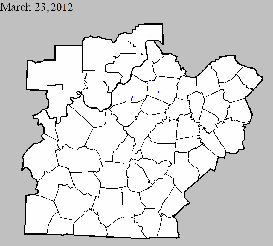
March 23, 2012
County: Jefferson, KY
EF-Scale: EF-1
Deaths: 0
Injuries: 0
Path width: 70 yards
Path length: 2.5 miles
Time: 2:07pm EDT
Notes: This tornado touched down just north of the intersection of Cedar Creek Road and Mount Washington Road, and lifted just northeast of the intersection of Cedar Creek Road and Long Rifle Lane. The most significant damage was done on Brook Chase Court, about in the middle pf the path.
March 23, 2012
County: Shelby
EF-Scale: EF-1
Deaths: 0
Injuries: 0
Path width: 50 yards
Path length: 2.25 miles
Time: 2:28pm EDT
Notes: The tornado traveled mainly over plowed fields, but was witnessed by at least three people and did do some damage to farms. Two barns were destroyed, two barns suffered significant roof and structural damage, and about two dozen trees were snapped or uprooted.
Current Hazards
Hazardous Weather Outlook
Storm Prediction Center
Submit a Storm Report
Advisory/Warning Criteria
Radar
Fort Knox
Evansville
Fort Campbell
Nashville
Jackson
Wilmington
Latest Forecasts
El Nino and La Nina
Climate Prediction
Central U.S. Weather Stories
1-Stop Winter Forecast
Aviation
Spot Request
Air Quality
Fire Weather
Recreation Forecasts
1-Stop Drought
Event Ready
1-Stop Severe Forecast
Past Weather
Climate Graphs
1-Stop Climate
CoCoRaHS
Local Climate Pages
Tornado History
Past Derby/Oaks/Thunder Weather
Football Weather
Local Information
About the NWS
Forecast Discussion
Items of Interest
Spotter Training
Regional Weather Map
Decision Support Page
Text Products
Science and Technology
Outreach
LMK Warning Area
About Our Office
Station History
Hazardous Weather Outlook
Local Climate Page
Tornado Machine Plans
Weather Enterprise Resources
US Dept of Commerce
National Oceanic and Atmospheric Administration
National Weather Service
Louisville, KY
6201 Theiler Lane
Louisville, KY 40229-1476
502-969-8842
Comments? Questions? Please Contact Us.
Thank you for visiting a National Oceanic and Atmospheric Administration (NOAA) website. The link you have selected will take you to a non-U.S. Government website for additional information.
NOAA is not responsible for the content of any linked website not operated by NOAA. This link is provided solely for your information and convenience, and does not imply any endorsement by NOAA or the U.S. Department of Commerce of the linked website or any information, products, or services contained therein.
You will be redirected to:


 Weather Map
 Local Radar