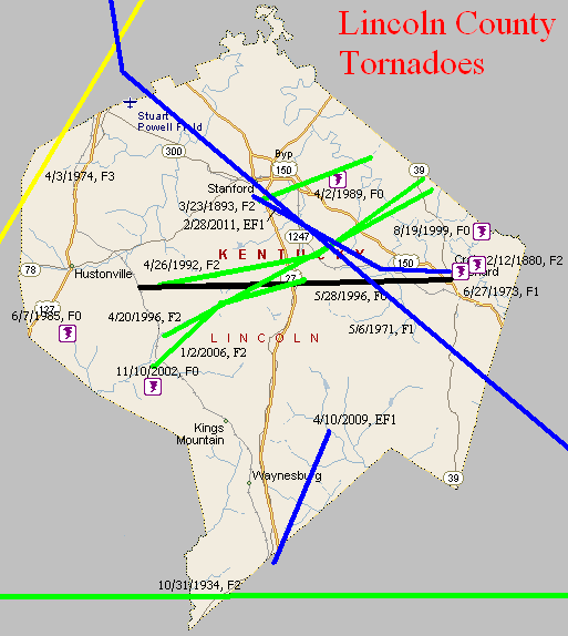
February 12, 1880
Counties: Lincoln
F-scale: F2
Deaths:
Injuries:
Path width:
Path length:
Time: 12:30pm
Narrative: Coincidentally enough, a tornado hit Lincoln County on Abraham Lincoln's birthday. Homes and other buildings were unroofed at Crab Orchard Springs.
March 23, 1893
Counties: Lincoln
F-scale: F2
Deaths: 0
Injuries: 3
Path width: 200 yards
Path length: 5 miles
Time:
Narrative: Moved east from the southeast edge of Stanford, passing near Rowland, two miles east of Stanford. Homes and businesses were destroyed. Mail from the post office was found up to two miles away.
October 31, 1934
Counties: Casey, Lincoln, Pulaski (and on into Rockcastle and Laurel)
F-scale: F2
Deaths: 6
Injuries: 32
Path width: 300 yards
Path length: 45 miles (probably a family of skipping tornadoes)
Time: 5:30pm
Narrative: A complex series of tornadoes and downbursts produced over $350,000 damage in a nine-county area of central Kentucky. The destruction of forty barns in Hart County and damage to 57 homes in Taylor County was likely from straight-line downburst winds. The likelihood of tornado involvement seemed to begin near Gilpin, continued east, passing south of Eubank, and ending in northern Laurel County. One person died in a home near Gilpin. A mother and four children died in one home on the Laurel County side of the Rockcastle River, fifteen miles northwest of London. Their home, which was destroyed, caught fire and only one child could be rescued. Most of the injuries were in the Gilpin-Mount Olive area.
May 6, 1971
Counties: Boyle and Lincoln (and on into Rockcastle)
F-scale: F1
Deaths: 0
Injuries: 0
Path width: 33 yards
Path length: 34 miles (skipping)
Time: 1:55pm EST
Notes: Tornado touched down on the northwest side of Danville. It initially moved south, damaging a farm south of town on Hustonville Road. A number of roofs were removed and walls blown out along the path through Danville. Boyle County Stockyards lost roofs. There was about $250,000 (1971) damage done in Danville. Funnels were sighted by the public. Winds in Danville were estimated at over 100 mph. Moving into Lincoln County, two barns were destroyed. At Stanford the sky was "filled with debris" and funnels were again sighted, along with scattered damage. The tornado then proceeded into Rockcastle County, doing additional damage at Wildie.
June 27, 1973
Counties: Lincoln
F-scale: F1
Deaths:
Injuries:
Path width:
Path length:
Time: 1:00pm
Noted discrepancies: SPC gives a path width of 10 yards, NCDC 30 yards.
April 3, 1974
Counties: Casey, Lincoln, Boyle
F-scale: F3
Deaths: 1
Injuries: 98
Path width:
Path length: 18 miles
Time: 5:35pm
Grazulis narrative: Moved north-northeast from five miles southwest of Hustonville, passing through Junction City and ending at the south end of Lake Herrington northeast of Danville. Over 100 homes were severely damaged or destroyed at Junction City. Losses totalled five million dollars in Lincoln County.
Noted discrepancies: SPC and NCDC give a path length of 21 miles...Grazulis give 18 miles. SPC gives a path width of 10 yards, NCDC gives 30 yards, Grazulis doesn't know. Grazulis lists this tornado at 6:35pm.
June 7, 1985
Counties: Lincoln
F-scale: F0
Deaths:
Injuries:
Path width:
Path length:
Time: 10:39am
Noted discrepancies: None
April 2, 1989
Counties: Lincoln
F-scale: F0
Deaths:
Injuries:
Path width:
Path length:
Time: 7:10pm
Noted discrepancies: None
April 20, 1996
Counties: Lincoln
F-scale: F2
Deaths:
Injuries: 7
Path width:
Path length:
Time: 3:26am
Notes: Storm Data says this tornado went from near McKinney to Preachersville to near the Garrard County line, damaging the county fairgrounds and Maywood.
May 28, 1996
Counties: Lincoln
F-scale: F0
Deaths:
Injuries:
Path width:
Path length:
Time: 8:35pm
Notes: Storm Data says this tornado moved from McKinney to Crab Orchard.
August 19, 1999
Counties: Lincoln
F-scale: F0
Deaths:
Injuries:
Path width:
Path length:
Time: 2:00pm
Notes: Storm Data puts this tornado two miles north of Crab Orchard.
November 10, 2002
Counties: Lincoln
F-scale: F0
Deaths:
Injuries:
Path width:
Path length:
Time: 7:45pm
Noted discrepancies: SPC lists a path width of 7 yards, NCDC 27 yards, Storm Data 25 yards.
Notes: Storm Data says this tornado struck Angel Ridge.
January 2, 2006
Counties: Lincoln
F-scale: F2
Deaths: 0
Injuries: 2
Path width: 200 yards
Path length: 9 miles
Time: 4:34pm
Notes: This tornado passed through western and central Lincoln County. A man received minor injuries when a barn he was in collapsed around him. An elderly woman was hospitalized with a broken collar bone and nose. She had been sucked out of her mobile home when she tried to open her front door. In all, eight mobile homes were destroyed, with most of the damage concentrated south of McKinney. At one location the tornado had embedded two by six boards firmly into the ground.
April 10, 2009
Counties: Lincoln (from Pulaski)
EF-scale: EF1
Deaths: 0
Injuries: 0
Path width: 100 yards
Path length: 6.5 miles
Time: 3:17pm EDT - 3:27pm EDT
Notes: Once the tornado crossed into Lincoln County, it first destroyed a metal shed and blew it 700 feet away. Half of the roof of a mobile home was also taken off. The tornado then crossed US 27, destroying several barns, uprooting and snapping trees, and damaging several homes. Three miles east of Waynesburg a mobile home was completely destroyed and a house was pushed 30 feet off of its foundation. The tornado was at its strongest right before it dissipated. The tornado went over a hill and down into a holler where multiple vortices were witnessed. A mobile home was destroyed and a conventional home was shoved 10 feet off of its foundation. The tornado dissipated about a minute later.
February 28, 2011
Counties: Lincoln
F-scale: EF1
Deaths: 0
Injuries: 0
Path width: 250 yards
Path length: 8.2 miles
Time: 6:49am EST
Notes: The tornado first touched down about 0.8 miles southwest of Stanford. It then traveled southeast damaging the middle school complex on Highway 27 about a mile south of Stanford. The tornado continued to damage large barns and out buildings as well as snap trees until it lifted about 2 miles northwest of Crab Orchard.


 Weather Story
 Weather Map
 Local Radar