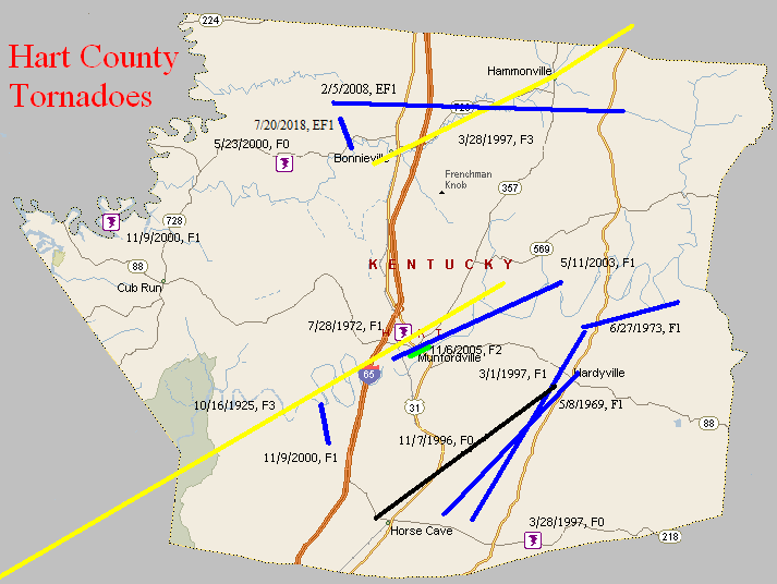
October 16, 1925
Counties: Warren, Edmonson, Hart
F-scale: F3
Deaths: 1
Injuries: 44
Path width: 300 yards
Path length: 45 miles (probably a family of tornadoes)
Time: 4:00pm
Notes: A family of tornadoes and downbursts moved from six miles west of Bowling Green to beyond Munfordville. Homes were wrecked near Kuykendall's Store west of Bowling Green and in Davenport on Barren River Pike. Three houses and four barns were blown into the Barren River at Thomas Landing, injuring ten people. A car was blown off the road, over a fence, and into a field. The vehicle landed on its tires and the driver survived, despite the top half of the car getting sheared off. Additional damage occurred in the Richardsville area. In Edmonson County, barns and a hotel were torn apart near Mammoth Cave National Park, along with the home of a cave tour guide. In Hart County the tornado and its attendant straight-line winds mowed down a path five miles wide. Three people were injured as houses were unroofed and barns destroyed. Canmer and Woodsonville were the hardest struck districts. Seven barns were blown down near Munfordville.
May 8, 1969
Counties: Hart
F-scale: F1
Deaths: 0
Injuries: 1
Path width: 100 yards
Path length: 9 miles
Time: 6:15pm
Grazulis narrative: Moved northeast from three miles northeast of Horse Cave, to Uno, and on to Hardyville. Several houses and five barns were demolished. Most of the house damage was caused by falling trees.
Noted discrepancies: SPC and NCDC rank this as an F1, Grazulis gives it an F2. SPC and NCDC give it a path length of 9 miles, Grazulis and Storm Data give 8 miles. SPC and NCDC lat/lons start the tornado east of Horse Cave...Grazulis starts it northeast of Horse Cave.
Notes: Storm Data says this tornado struck three miles northeast of Horse Cave, and then to Uno and Hardyville, crossing KY 541 about two miles west of US 31E. However, KY 541 is in Breathitt County. Probably meant KY 571.
July 28, 1972
Counties: Hart
F-scale: F1
Deaths:
Injuries:
Path width:
Path length:
Time: 6:30pm
Notes: According to Storm Data, this tornado damaged four city blocks on the west side of Munfordville.
June 27, 1973
Counties: Hart
F-scale: F1
Deaths:
Injuries: 2
Path width:
Path length: 4 miles
Time: 3:30pm
Noted discrepancies: SPC gives a path width of 10 yards, NCDC gives 30 yards.
Narrative: Tornado touched down about a mile southwest of Canmer and moved to the east-northeast. In the Canmer area, Gilead Church (near the intersection of US 31E and Gilead Fairview Road) lost its roof, and debris from the roof was found two miles away. A house under construction collapsed and injured the man inside, while another man was pulled from the garage and rolled across the ground. Several homes lost roofs. Hopewell Cumberland Presbyterian Church was damaged. Near the end of the track along Davis Bend Road, trees were blown down and 22 barns and stables were damaged or destroyed. Marble sized hail was also reported.
November 7, 1996
Counties: Hart
F-scale: F0
Deaths:
Injuries: 5
Path width:
Path length:
Time: 1:45pm
Notes: Storm Data mentions damage at Horse Cave and Hardyville.
March 1, 1997
Counties: Hart
F-scale: F1
Deaths:
Injuries:
Path width:
Path length:
Time: 10:00pm
Notes: Storm Data places this tornado near Hardyville.
March 28, 1997
Counties: Hart, LaRue
F-scale: F3
Deaths: 1
Injuries: 15
Path width:
Path length:
Time: 6:04pm
Noted discrepancies: SPC/NCDC endpoint lat/lon for this tornado is in LaRue County, and narrative at NCDC includes LaRue County. LaRue County is also included for this tornado at the NCDC website. For this project this tornado was mapped all the way to the SPC/NCDC ending lat/lon in LaRue County. Upon further investigation it appears that this tornado was split into two at SPC. Storm Data says this twister touched down at Bonnieville in Hart County and moved to Magnolia in LaRue County before lifting. Hammonville was struck. The tornado crossed I-65 at Exit 71.
March 28, 1997
Counties: Hart
F-scale: F0
Deaths:
Injuries:
Path width:
Path length:
Time: 10:28pm
Notes: According to Storm Data this tornado touched down near Seymour.
May 23, 2000
Counties: Hart
F-scale: F0
Deaths:
Injuries:
Path width:
Path length:
Time: 1:25pm
Notes: SPC lists a path width of 20 yards, NCDC 27 yards, Storm Data 25 yards.
Notes: Storm Data puts this on the northwest side of Priceville.
November 9, 2000
Counties: Hart
F-scale: F1
Deaths:
Injuries:
Path width:
Path length:
Time: 1:06pm
Notes: Storm Data takes this tornado from one mile southwest of Blowing Springs to one mile northwest of Blowing Springs.
November 9, 2000
Counties: Hart
F-scale: F1
Deaths:
Injuries:
Path width:
Path length:
Time: 1:15pm
Noted discrepancies: SPC lists a path width of 70 yards, NCDC 73 yards, Storm Data 75 yards. The lat/lon for this tornado shows it moving northwest, though no mention of that is made in the NCDC narrative. Storm Data moved this tornado from three miles northwest of Horse Cave to five miles northwest of Horse Cave.
May 11, 2003
Counties: Hart
F-scale: F1
Deaths:
Injuries:
Path width:
Path length:
Time: 3:59am
Notes: Storm Data says this tornado touched down on Rowlette Street one mile west southwest of Munfordville and on KY 537, and moved northeast toward Glen Lily one mile east-northeast of Munfordville.
November 6, 2005
Counties: Hart
F-scale: F2
Deaths: 0
Injuries: 0
Path width: 200 yards
Path length: 1 mile
Time: 4:41am
Notes: This tornado struck downtown Munfordville. The tornado caused major damage to 44 homes and two businesses. Twenty-five homes were declared uninhabitable. Six businesses and 34 homes had minor damage. Munfordville Elementary School had part of its roof removed. About 50 vehicles in a car dealership lot were totaled.
February 5, 2008
Counties: Hart
EF-scale: EF1
Deaths: 0
Injuries: 0
Path width: 150 yards
Path length: 10.5 miles
Time: 11:32pm CST to 11:43pm CST
Notes: The tornado first touched down near Lone Star, where it destroyed several barns and a mobile home. The tornado next touched down along US 31W north of Bonnieville, where it heavily damaged or destroyed several more barns and mobile homes. It touched down again near the intersection of Hammonville and Bacon Creek roads. Here, it caused minor damage to some homes, destroyed a barn, and damaged the roof of another. The tornado continued on eastward, where it damaged several barns near US 31E.
July 20, 2018
County: Hart
EF-Scale: EF1
Deaths: 0
Injuries: 0
Path width: 60 yards
Path length: 1.2 miles
Time: 9:56pm - 9:59pm CDT
Notes: This tornado touched down in a wooded area midway between J Riggs Rd and Copelin Rd north of KY 728, snapping trees as it moved southeast along a hay field where it destroyed two 1200 lb hay bales and rolled numerous others up to a tenth of a mile into a soybean field and uphill onto a knoll. Snapping trees on the land adjacent to the hay and soybean fields, the tornado took a slight right turn, crossing KY 728, and destroyed a large barn. Large parts of the barn debris were lofted into trees southwest of the structure, snapping their trunks. A 20 x 20 section of the barn was blown 500 feet to the south-southeast. The tornado continued southward for another two-tenths of a mile, downing trees along Campground Rd before lifting.


 Weather Story
 Weather Map
 Local Radar