October 29, 1883
Counties: Bourbon
F-scale: F1
Deaths: 2
Injuries: 1
Path width:
Path length: 6 miles
Time: 2:00am
Grazulis Narrative: Tornado moved from "Husto" to "Kinney Station". Two people were killed in one rural building. Most of the path was through dense forest.
NWS Notes: While Lexington newspapers listed the many farms that were struck by the tornado (or its attendant straight-line winds), no road names and few references to nearby towns were given. However, Grazulis's "Kinney Station" was likely Kenney Station, which today is Monterey, located 4 miles southwest of Paris. "Husto" was possibly Huston, named for a local landowner with that name, though it is unclear exactly where Huston was located, though it may have been where Paris sits today. Lexington newspapers stated that the "cyclone did great damage," including unroofing J. L. Taylor's clothing store across the street from the courthouse in Paris. Warehouses were unroofed along Stoner's Creek. G. W. Bedford's barn was blown down, and an old stone house on the Clay Farm was destroyed, killing two people inside the house (Maria Johnson and a young boy). The Morris Gass Farm also received damage. The cyclone moved from south to north "over the lower edge" of Paris. Several buildings were unroofed. The warehouse of Mr. Tarr was completely destroyed. "Several church spires were bent, while the dome on the courthouse rocked to and fro at an alarming rate. The track of the cyclone was very narrow." It appears that tornadoes may have also struck Franklin, Anderson, and Fayette Counties on this day.
April 22, 1887
Counties: Bourbon
F-scale: F2
Deaths: 0
Injuries: 0
Path width: 400 yards
Path length:
Time: 8:00am
Notes: More specific information is needed to accurately map this tornado. A tornado leveled trees and unroofed houses along a track 400 yards wide "at Paris" or "near Paris" (depending on the source used). White's Distillery's roof was blown "out of sight." The Turney, Clark, and Company livery stable was blown across the street. Mrs. Herrick's boarding house was nearly demolished, and the Paris Flour Mill's roof was damaged. Mrs. Carson's roof was carried across the street. The Daily Press said, "A tornado struck the city with inconceivable energy." While there were heavy property losses, no one was killed.
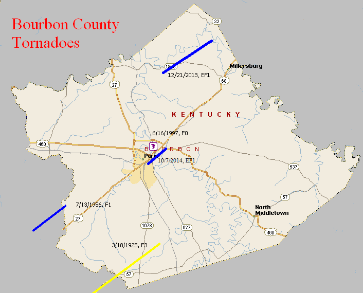
March 18, 1925
Counties: Marion, Washington KY, Mercer, Jessamine, Fayette, Bourbon
F-scale: F3
Deaths: 2
Injuries: 40
Path width: 300 yards
Path length: 60 miles (skipping)
Time: 6:30pm
Notes: What was almost certainly a family of tornadoes moved northeast from western Marion County (according to Grazulis) to 4 miles southwest of Paris in Bourbon County. This project has so far been unable to find any damage in Marion or Jessamine Counties. In Washington County many buildings across the county were leveled. The country home of Judge Case near Springfield was unroofed. The "Negro section" of Jimtown was destroyed, and all 25 houses in Jimtown were razed after the storm. In Springfield 30 people were injured and 2 were killed (the two fatalities may have been from Jimtown). Moving into Mercer County, two barns were lost on the Bond Farm. A barn was damaged and a house unroofed on the Terhune Farm, barns were blown down on the Quartz and Shelton Farms, a house and a barn were lost on the Sanford Farm, and the home of Kye Crossfield at Ebenezer was destroyed. The tornado was 1/4 mile wide in Mercer County. After possibly weakening or lifting in Jessamine County, the tornado slammed into eastern sections of Fayette County with renewed vigor. Trees were blown down on Chilesburg Road, and many trees and fences were torn down on the John E. Madden Farm on Winchester Road about four miles out of Lexington (roughly where Winchester Road meets I-75 today). The tornado reached its peak strength, high-end F3 (possibly F4) over a four-mile stretch of eastern Fayette County. About five and a half miles from Lexington on Briar Hill Road the twister devastated the Kelley Farm. Mrs. Kelley's 40-year-old "Negro hired hand" was blown 300 yards to his death. Nearly every bone in his body was broken. His right hip was dislocated to the point where it was alongside his chest. No trace of his cabin was ever found. The two-story eight-room main residence was "torn from its foundations" and reduced to a pile of rubble. The farm's chickens were stripped of their feathers. According to witnesses, the tornado was "cone-shaped and had a large black cloud at its top, coming out of the west. A pillar of flame shot skyward when the vortex of the twister struck the Kelley residence." Trees and telephone poles were blown down for a mile along Briar Hill Road. The Jonas Weil Farm on Briar Hill Road suffered an unroofed home, two miles of destroyed fence, and 500 felled trees. Moving along to the northeast, the Muir area was next in line (near the intersection of KY 1970 and KY 1973 today). William Johnson's residence on Muir Pike was "piled upon its foundations and partly blown away." The Deaver Farm was damaged, and a 15 pound rock was blown through a wall like a cannonball. Many trees were blown down. Proceeding into Bourbon County, the house of Rodes Donald had two rooms blown away, the Dudley School was moved four feet off its foundation, fifty trees were blown down on the Ewing Farm, and the Spears Farm on Stewart Road was damaged. The tornado then finally began to weaken and it dissipated about four miles shy of Paris.
July 13, 1956
Counties: Fayette, Bourbon
F-scale: F1
Deaths: 0
Injuries: 0
Path width: 30 yards
Path length: 3 miles
Time: 5:00pm
Grazulis Narrative: Moved northeast from extreme northeast Fayette County, tearing apart four farms. At least one barn was destroyed.
Noted discrepancies: SPC and NCDC list this as an F1...Grazulis calls it an F2. SPC and NCDC give a time of 6:00pm, Storm Data gives 5:00pm, Grazulis says 6:30pm. SPC gives a path length of 1/10 of a mile...NCDC gives nothing...Grazulis gives 3 miles. SPC and Grazulis give a path width of 30 yards...NCDC gives nothing...Storm Data says 38 yards. SPC and NCDC give only a touchdown point (which agrees with Grazulis' touchdown point), but no lift-off point.
June 16, 1997
Counties: Bourbon
F-scale: F0
Deaths:
Injuries:
Path width:
Path length:
Time: 7:15pm
Noted discrepancies: None
December 21, 2013
County: Bourbon
EF-Scale: EF1
Deaths: 0
Injuries: 0
Path width: 125 yards
Path length: 4.8 miles
Time: 11:41pm - 11:45pm EST
Notes: The NWS storm survey team found many areas of straight line wind damage across northern Bourbon County, and one specific tornado path within the straight line wind damage. There were many barns damaged or destroyed, power lines and poles down or snapped, and many softwood and hardwood trees snapped, twisted, and uprooted. Several homes and outbuildings had roof damage. The most concentrated damage was along Colville Road, down Endicott Lane, and over to the Steele Ford Road area. In this area, several large barns, garages, and outbuildings were either destroyed or sustained significant damage, with debris thrown to the north, northeast, and east. In addition, some well anchored solid footers from a garage and barn at 201 Endicott Lane were lifted up and thrown 75 yards. Several residents reported a loud roar, their ears popped, and there was zero visibility in torrential rain when the storm struck.
October 7, 2014
County: Bourbon
EF-Scale: EF1
Deaths: 0
Injuries: 1
Path width: 60 yards
Path length: 1.7 miles
Time: 4:12pm - 4:13pm EDT
Notes: Touchdown occurred near the Vine Street loop where damage was done to homes' roofs and siding. One woman was pulled out of her house and landed on her porch. Power lines and many trees were downed, some of which fell on homes. Tree and house damage also occurred at the end of Windamere Lane, and warehouses were damaged just before the tornado lifted at US 460.


 Weather Story
 Weather Map
 Local Radar