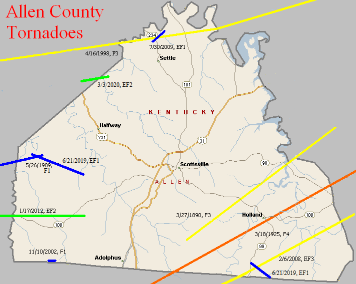
March 27, 1890
Counties: Allen, Barren
F-scale: F3
Deaths: 4
Injuries: 25
Path width: 600 yards
Path length: 15 miles
Time: 9:00pm
Narrative: Moved northeast from five miles south of Scottsville to near Tracy. Four people were killed in Allen County as at least three homes were destroyed. Death toll may have been as high as 17.
March 18, 1925
Counties: Allen, Barren, Monroe, Metcalfe (from Sumner TN)
F-scale: F4
Deaths: 39
Injuries: 95
Path width: 400 yards
Path length: 60 miles (probably a family of tornadoes)
Time: 5:00pm
Narrative: From one of the worst tornado outbreaks ever to strike central Kentucky. This tornado moved east-northeast from near Buck Lodge, eight miles north of Gallatin. Homes were swept away in many communities, including Keytown, Angle, Oak Grove, and Liberty. As many as eight people died in one home. Trees were blown down in the steep valleys as well as on the hilltops. At least 27 people died in Tennessee. Crossing into Kentucky, the tornado struck Mt. Union (near the present-day intersection of KY 1421 and Napier Road) and then Holland, killing four. The funnel may have either weakened or lifted over southern Barren County before striking Beaumont in Metcalfe County. There it killed eight more, including five in one family. Over 150 homes were damaged or destroyed.
May 26, 1989
Counties: Simpson, Allen
F-Scale: F1
Deaths:
Injuries:
Path width:
Path length:
Time: 3:27pm
Notes: Storm Data says this tornado did damage on Kinnard Road, passed Gold City, and ended one mile northeast of Mount Aerial (about two miles into Allen County). Using Storm Data information plus SPC's lift-off point work well for plotting this.
April 16, 1998
Counties: Logan, Warren, Allen, Barren
F-Scale: F3
Deaths: 2
Injuries: 9
Path width:
Path length: 58 miles
Time: 2:35pm
Notes: After researching this tornado (see discrepancies below), including reviewing radar data, it appears this tornado touched down at Chandlers Chapel in northeast Logan County, moving through Warren County crossing I-65 about seven and a half miles south of Bowling Green, continuing eastward into northernmost Allen County passing just north of Meador, then turning to the northeast near Finny, Haywood, three miles south of Glasgow, and ending at the Metcalfe County line near where the parkway crosses the border. The worst damage was in Barren County. Homes on Needmore School Road southwest of Haywood were extensively damaged, and a mobile home was flipped over near the intersection of Riddle Road and KY 249. In Glasgow one person was killed in his mobile home and another was killed by flying debris. In the Glasgow area one house was destroyed (F3 damage) and 45 badly damaged. Winds estimated at 175mph near Glasgow damaged or destroyed 35 mobile homes and 25 barns.
Noted Discrepancies: SPC mistakenly replaces Warren County with Lawrence County. SPC gives a beginning latitude of 36.92...NCDC gives 36.95. SPC gives a path width of 100 yards, NCDC gives 200 yards. The lat/lons given for this event are all over the place. Going by the beginning lat/lon in Logan County and the ending lat/lon in Barren County, the track would go through the south side of Glasgow and would end at the Barren/Metcalfe county line, which agrees with the narrative given at NCDC. However, this path would completely miss Allen County. Storm Data has it in Logan County (Chandlers Chapel to six miles east of Chandlers Chapel), Warren County (ten miles southwest of Bowling Green to sixteen miles southeast of Bowling Green), Allen County (three miles west of Meador to two miles east of Meador), and Barren County (fourteen miles southwest of Glasgow to ten miles east of Glasgow, with Glasgow hard hit).
November 10, 2002
Counties: Allen
F-Scale: F1
Deaths:
Injuries:
Path width: 25 yards
Path length:
Time: 2:00am
Notes: Storm Data says this occurred near New Roe. Lat/lon given place it in Sumner County, Tennessee. Will plot it between New Roe and the Tennessee border.
Noted discrepancies: SPC lists a path width of 7 yards, NCDC 27 yards, Storm Data 25 yards.
February 6, 2008
Counties: Allen, Monroe (from Macon, TN)
EF-Scale: EF3
Deaths: 4
Injuries: 11
Path width: 440 yards
Path length: 10.4 miles
Time: 1:40am CST to 1:53am CST
Notes: This tornado destroyed 12 homes and mobile homes, mainly in the Amos community and in the Tracy Lane area. Many other homes and buildings were damaged. Four people were killed near Tracy Lane, and eleven others were injured in southeast Allen County. The tornado continued through rural and wooded sections of eastern Allen County, and crossed into Monroe County near Fountain Run.
July 30, 2009
County: Allen
EF-Scale: EF1
Deaths: 0
Injuries: 0
Path width: 200 yards
Path length: 1 mile
Time: 11:35 - 11:40pm CDT
Notes: A small tornado touched down near the intersection of state routes 234 and 1533 near the northern tip of Allen County. Most of the damage was to trees, and there was some minor structural damage to two farms. Three track maps are available: zoomed in (local view), zoomed out (regional view), and a satellite map withdamage points plotted.
January 17, 2012
Counties: Simpson, Allen
EF-Scale: EF-2
Deaths: 0
Injuries: 0
Path width: 150 yards
Path length: 9 miles
Time: 12:20pm CST
Notes: This tornado touched down near Hickory Flat Road just south of its intersection with Hickory Flat-Ridge Road in Simpson County where about a dozen trees were uprooted. The most significant damage occurred near the intersection of McKendree Church Road and Highway 100 where a well constructed brick house completely lost its roof. Multiple barns, garages, and outbuildings were destroyed here as well. Nearly a complete roof of one outbuilding was project 1/2 mile to the east. Another area of significant damage was at the intersection of Highway 100 and Reeder School Road (near the Simpson/Allen County line) where a house had significant roof damage and had an exterior wall blown out. A jeep in the driveway was blown into the house and a camper was blown from the driveway across the road with debris scattered through the field beyond. Damage continued east into Allen County with the last evidence of damage at Walker Chapel Road about a mile south of Highway 100.
June 21, 2019
County: Allen
EF-Scale: EF1
Deaths: 0
Injuries: 0
Path width: 125 yards
Path length: 4.6 mile
Time: 7:39pm CDT
Notes: There was significant straight line wind damage across much of the county facing an easterly and southeasterly direction. Interspersed with the straight line wind damage was at least one tornado in western Allen County north of and paralleling KY 585. The tornado touched down near the Horseshoe Ford Road and Horseshoe Bend Road intersection. There were numerous large hardwood trees split, twisted, and uprooted facing from northerly to southeasterly. Horseshoe Bend Road was closed due to trees down across the road and from flooding. Winds in this area were estimated to be between 90 and 95 mph. Further east along Mayhew Road a large, well-built barn was uplifted and removed from its foundation with several cedar and maple trees twisted and snapped. Across a farmer's field, corn was flattened and twisted in multiple directions. Large, heavy fuel tanks were rolled in two different directions on Mayhew Road. Several barns and outbuildings had roof damage as well. At the Mayhew and Pope Road intersection there was extensive softwood and hardwood tree damage, especially around the Harmony Missionary Baptist Church at 5226 Pope Road. Residents said there was a major pressure change with the tornado. There were indications there may have been more than one tornado as tree positions would go from a tornadic circulation of northeasterly to southeasterly direction and then to all straight line wind damage in an easterly wind direction, then back to a tornadic circulation in multiple directions. The width of the individual circulations varied between 75 and 125 yards with widespread straight line wind damage all around. Most of the wind damage was between 85 and 95 mph. More tree and power line damage was along KY 585 near Shores Road. The tornado dissipated halfway between the intersection of KY 585 and Shores Road and the intersection of Shirk Road and Grider Drive.
June 21, 2019
County: Allen
EF-Scale: EF1
Deaths: 0
Injuries: 0
Path width: 125 yards
Path length: 1.6 mile
Time: 8:04pm CDT
Notes: Interspersed among straight-line wind damage was a tornado that first touched down a half mile east of Amos. A family farm had numerous trees twisted, snapped, and uprooted. Several barns sustained severe structural damage to the roofs. A dozen or so portions of two-by-fours were impaled into the ground in multiple directions. Further southeast on Highland Church Road numerous trees were uprooted and snapped with trees facing from the north northeast to the southeast. The tornado continued to the Tennessee state line. At 2592 Highland Church Road (Highland General Baptist Church) there was significant brick damage on the west, south, and east sides of the church due to open vents.
March 3, 2020
County: Warren, Allen
EF-Scale: EF2
Deaths: 0
Injuries: 0
Path width: 250 yards
Path length: 2.2 mile
Time: 12:15am CST
Notes: Most of the damage was around the southeastern portion of the Alvaton community. The tornado was preceded by straight-line winds, then just east of Claypool Boyce Road there was a distinct change in the tree pattern. Instead of just going to the northeast trees were now going to the northwest, north and northeast. A large 2 x 8 went flying and got wedged between the windshield wiper and the windshield of a vehicle but incredibly did not crack the windshield. This is where a small tornado formed within the straight-line wind path with winds between 80 and 85 mph. Residents reported half inch hail, followed by a surge in lightning, then quiet, then a 20 second loud roar with popping in their ears followed by complete silence again. Further east in the 500 block of Kara Court there was significant tree damage with the back of a house being uplifted and insulation being thrown upwind and downwind around the back of the house. Trees were laying in all directions with lots of twisting and many snapped trees. At the 200 block of Cross Creek Court was the clearest evidence of trees facing all eight cardinal directions. In this area many trees were snapped and uprooted. The survey team estimated well over 500 trees in a 1 mile stretch uprooted, snapped, or pushed over. Two of the snapped trees landed on pick-up trucks. Winds increased to 95 mph with a width of 225 yards. At the 2400 block of WG Talley Road was the most significant damage of the entire survey. Three barns were destroyed, 2 of them were concreted in strong firm footers. One of the barns was 30 x 80, one was 150 x 100, and one was 12 x 16 along with numerous sheds destroyed, and debris was thrown in all directions downwind up to 500 yards. A 5000 pound horse trailer was thrown to the northwest 70 yards. A very well-built family residence took a direct hit from the EF2 tornado, with the front side of the home having the plywood exposed and with most of the shingles gone but the rest of the house fully intact due to the house having all the proper clips and braces with rebar. Wind speeds at this point were 116 mph with a width of 250 yards. Tree damage continued into Allen County along Allen Springs Road. The tornado lifted just north of Bailey School Road in far NW Allen County.


 Weather Story
 Weather Map
 Local Radar