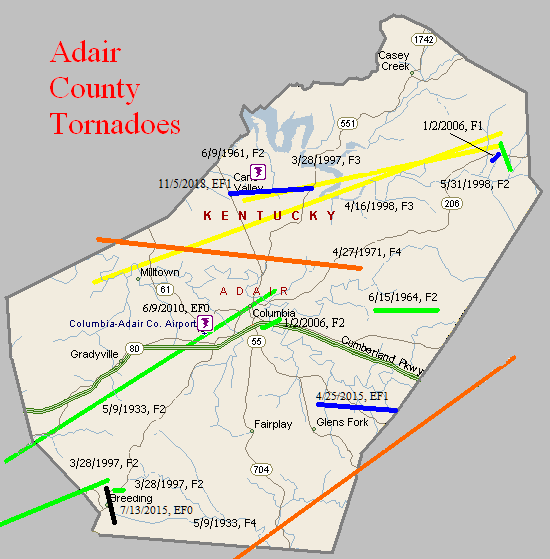
May 9, 1933
Counties: Monroe, Cumberland, Adair, Russell
F-scale: F4
Deaths: 36
Injuries: 87
Path width: 800 yards
Path length: 60 miles (probably a family of tornadoes)
Time: 8:30pm
Notes: This historic event began around 8pm when there was 30 minutes of rain and hail in Tompkinsville, followed by five minutes of absolute calm. The calm was shattered when a tornado touched down just southwest of town and moved northeast, directly into southern sections the city (the "Negro section," as newspapers called it at the time). The path of utter destruction, in which everything was flattened, was a quarter mile wide. The damaged residences of O. C. Landrum and Oscar Sims marked the edges of the devastation. Between them was a treeless and fenceless waste, with scattered remnants of homes and uprooted trees. A heavy rain, which fell continuously from 1 o'clock until 6 the following morning, made roads almost impassable and handicapped the work of rehabilitation. Only three homes that were affected by the funnel were able to be salvaged. World War I veterans described the devastation and suffering as worse than what they witnessed during the Great War. The twisting nature of the winds was clearly revealed when the bodies of the Tyree family were found 75 yards south of their home site, and the bodies of the Redeford family were discovered 100 yards north of the spot where their home had stood. The Tyrees lived on the southern edge of the storm area, while the Redefords lived near the northern edge. The body of the Rev. Redeford's wife was carried 150 yards to a pond on the land belonging to L. P. Hagan. The corpse of the husband was found entangled in a barbed wire fence, having been blown about one hundred yards. Sixteen people in Tompkinsville lost their lives that evening, with another 2 deaths just northeast of town in Sewell. Fifty citizens were injured in Monroe County. After Tompkinsville, the tornado continued to the northeast, crossing Cumberland County (2 people injured) and clipping the southeast corner of Adair County (2 people killed in the Cundiff area) with comparatively little damage, before intensifying again as it entered Russell County. The tornado grew into a mile-wide monster as it plowed down at least 100 homes. The edge of the tornado missed downtown Russell Springs by only half a mile. The tornado spent its last fury in the Happy Acre area, causing damage along Goose Creek, near Friendship Church, and on the southern end of Bethany Ridge where chickens were stripped of their feathers. The tornado lifted at the Casey County line. Fatality counts for Russell County vary from 14 to 20 depending on the source...this study will use Grazulis' number of 18. Of those 18, 14 were killed on the southeast edge of Russell Springs. Up to 100 people may have been injured in Russell County.
May 9, 1933
Counties: Metcalfe, Adair
F-scale: F2
Deaths: 2
Injuries: 12
Path width: 400 yards
Path length: 15 miles
Time: 8:30pm
Narrative: Moved northeast, destroying five homes and damaging a dozen others at Columbia.
June 9, 1961
Counties: Adair
F-scale: F2
Deaths:
Injuries:
Path width:
Path length:
Time: 1:00pm
Noted discrepancies: SPC and NCDC rank this as an F2, Grazulis does not list it. SPC gives a path width of 10 yards, NCDC says 30 yards.
June 15, 1964
Counties: Adair
F-scale: F2
Deaths:
Injuries:
Path width:
Path length:
Time: 4:30pm
Noted discrepancies: SPC and NCDC list this as an F2...Grazulis does not list it.
April 27, 1971
Counties: Green, Adair
F-scale: F4
Deaths: 6
Injuries: 58
Path width: 100 yards
Path length: 15 miles
Time: 9:30pm CDT
Notes: Moved east-southeast from Bramlett, passing three miles northeast of Columbia, to Vester and Christine. Six people were killed when the tornado demolished a number of homes in the Mount Pleasant Church area on KY 551. The church itself was leveled. A total of 51 homes, 33 barns, three churches, four trailers, and 100 other buildings were destroyed, and fifty more homes had major damage.
Noted discrepancies: SPC and NCDC give a path length of 14 miles, Grazulis and Storm Data give 15.
March 28, 1997
Counties: Adair
F-scale: F3
Deaths:
Injuries: 7
Path width:
Path length:
Time: 7:15pm
Notes: Storm Data says this tornado touched down at Cane Valley and lifted around Pellyton.
Noted discrepancies: SPC lists the beginning and ending lat/lons as 36.88/-85.72, 37.03/-85.45...NCDC has 37.18/-85.32, 37.22/-85.08. SPC lists a path length of 15 miles...NCDC says 10 miles. The lat/lons and path lengths given here are the mirror image of the lat/lons and path lengths given in the next event.Storm Data
March 28, 1997
Counties: Metcalfe, Adair
F-scale: F2
Deaths: 1
Injuries: 6
Path width:
Path length:
Time: 7:15pm
Noted discrepancies: SPC has beginning and ending lat/lons as 37.18/-85.32, 37.22/-85.08...NCDC has 36.88/-85.72, 37.03/85.45. SPC has a path length of 10 miles...NCDC says 15 miles. The lat/lon issue and path length issue here are the mirror image of the lat/lon issue and path length issue of the previous tornado. End lat/lon takes this tornado into Adair County, which agrees with NCDC narrative. Will plot into Adair County. Storm Data lists this tornado as having struck both Metcalfe and Adair counties, touching down a mile west of Summer Shade at the intersection of KY 90 and Milam Clark Road, crossing KY 90 and KY 640, KY 163 south of Goodluck, lifting just north of Breeding.
March 28, 1997
Counties: Adair
F-scale: F2
Deaths:
Injuries:
Path width:
Path length:
Time: 7:45pm
Noted discrepancies: None
April 16, 1998
Counties: Adair
F-scale: F3
Deaths:
Injuries:
Path width:
Path length:
Time: 4:15pm
Notes: Storm Data says Pellyton was hard hit...tornado went from Portland to one mile northeast of Pellyton.
May 31, 1998
Counties: Adair
F-scale: F2
Deaths:
Injuries:
Path width:
Path length:
Time: 7:35pm
Notes: Storm Data takes this tornado from Pellyton to one mile southeast of Pellyton.
January 2, 2006
Counties: Adair
F-scale: F2
Deaths: 0
Injuries: 0
Path width: 200 yards
Path length: 1 mile
Time: 2:22pm CST
Notes: This tornado touched down near Columbia. It destroyed a mobile home and removed the roof from a house. Other homes and mobile homes were damaged.
January 2, 2006
Counties: Adair
F-scale: F1
Deaths: 0
Injuries: 0
Path width: 100 yards
Path length: 1 mile
Time: 2:57am CST
Notes: This tornado touched down in the Pellyton area. Several homes and barns were damaged.
June 9, 2010
Counties: Adair
F-scale: EF0
Deaths: 0
Injuries: 0
Path width: 40 yards
Path length: 0.6 mile
Time: 6:12pm CDT
Notes: A barn was destroyed and several trees were blown down west of Columbia.
April 25, 2015
County: Adair
EF-Scale: EF1
Deaths: 0
Injuries: 0
Path width: 150 yards
Path length: 3.8 miles
Time: 8:29pm - 8:36pm CDT
Notes: This tornado touched down 6 miles southeast of Columbia along Dale Morrison Road. Numerous trees were uprooted, a 145-foot barn was destroyed, and the top was sheared off an adjacent silo. The tornado then moved east into a wooded area, snapping and uprooting trees. It damaged three more barns and uprooted more trees along Montpelier Rd. A home near the intersection of Montpelier Rd and Old Montpelier Rd sustained minor siding damage.
July 13, 2015
County: Adair
EF-Scale: EF0
Deaths: 0
Injuries: 0
Path width: 35 yards
Path length: 1.5 miles
Time: 5:58pm - 6:00pm CDT
Notes: This small tornado destroyed one outbuilding in addition to uprooting and snapping limbs on several trees in a very narrow path near the community of Breeding.
November 5, 2018
County: Adair
EF-Scale: EF1
Deaths: 0
Injuries: 0
Path width: 150 yards
Path length: 3.8 miles
Time: 10:52pm - 10:56pm CST
Notes: This skipping tornado first touched down along Campbellsville Rd near the community of Cane Valley where it downed power lines as it snapped tree limbs and uprooted several large trees. Moving eastward over open fields, it tore most of the roof off a barn at the end of Doug White Road, plastering insulation from the barn onto the northeast side of the adjacent home. To the north of the barn and home, it tossed a 1500 lb. hay roll southeast over a fence. From here, the tornado raced east-northeast over more fields, where it snapped the tops off a few trees before it hit the next farm, at Milky Way Lane on Mt. Carmel Road. Here it destroyed one large outbuilding and tore much of the roof off another in addition to destroying two small grain hoppers. Flying debris damaged at least two other buildings and vehicles, with roofing debris scattered a quarter of a mile to the northeast. Across the road from these buildings, the tornado tore the roof off and partially collapsed the wall of another large outbuilding. Flying debris from this building damaged another outbuilding, while columns on the southwest-facing front porch of the farm home were blown out as the porch roof was briefly elevated. The tornado continued eastward, snapping the trunks of several large trees along Butler Creek and damaging carports and a metal outbuilding along Holmes Bend Rd and Turkey Trace. Again moving over open land, the final two buildings damaged were metal outbuildings on Willis Rd and near the intersection of West Egypt Rd and Knifley Rd. It also toppled the sign of the Green River Bait and Grocery before lifting as it crossed Knifley Rd.


 Weather Story
 Weather Map
 Local Radar