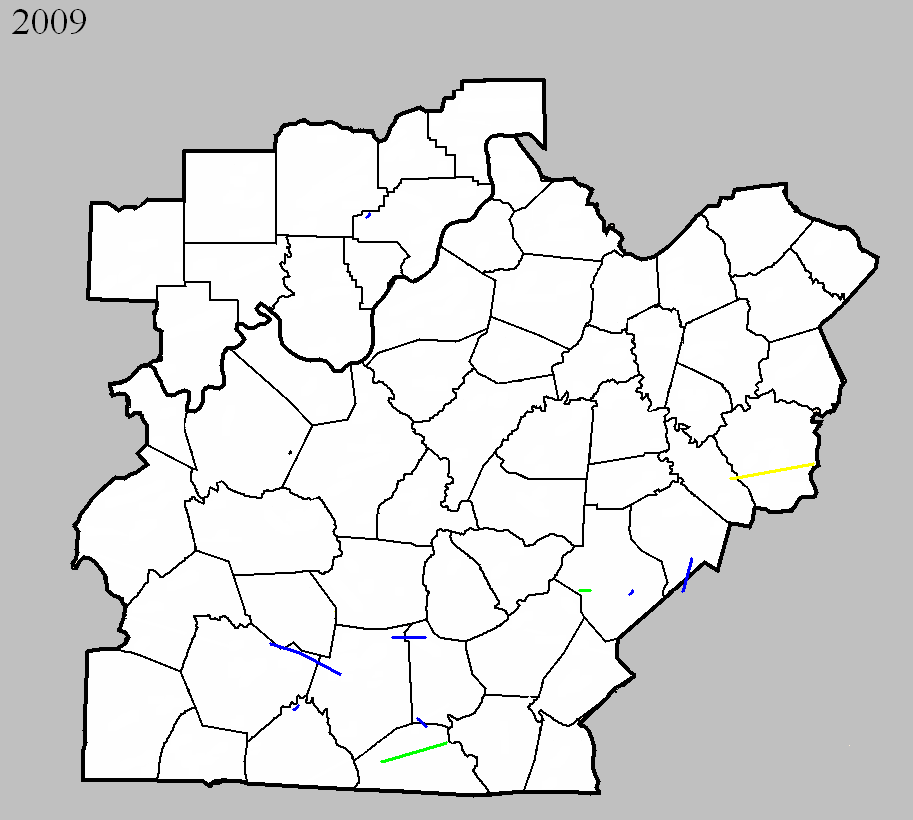
April 5, 2009
Counties: Casey
EF-scale: EF1
Deaths: 0
Injuries: 0
Path width: 50 yards
Path length: 1/2 mile
Time: 9:20pm EDT
Notes: One well-constructed home lost its roof, two barns were demolished, and numerous trees were felled.
April 10, 2009
Counties: Lincoln (from Pulaski)
EF-scale: EF1
Deaths: 0
Injuries: 0
Path width: 100 yards
Path length: 6.5 miles
Time: 3:17pm EDT - 3:27pm EDT
Notes: Once the tornado crossed into Lincoln County, it first destroyed a metal shed and blew it 700 feet away. Half of the roof of a mobile home was also taken off. The tornado then crossed US 27, destroying several barns, uprooting and snapping trees, and damaging several homes. Three miles east of Waynesburg a mobile home was completely destroyed and a house was pushed 30 feet off of its foundation. The tornado was at its strongest right before it dissipated. The tornado went over a hill and down into a holler where multiple vortices were witnessed. A mobile home was destroyed and a conventional home was shoved 10 feet off of its foundation. The tornado dissipated about a minute later.
May 8, 2009
Counties: Barren and Metcalfe
EF-scale: EF1
Deaths: 0
Injuries: 0
Path width: 30 yards
Path length: 4 miles (skipping)
Time: 3:04pm CDT - 3:11pm EDT
Notes: The tornado touched down just east of Hiseville on Buck Williams Road. A home and a small outbuilding were damaged, and numerous trees were uprooted. A piece of tin roofing ended up wrapped around a tree 500 yards to the east across an open field. The tornado peaked in intensity on a farm just north of Sexton Lane. Three outbuildings and a well-constructed barn were destroyed. Debris from these structures was found up to 300 yards to the east in a pond. In Metcalfe County, south of Center, a pole barn was uplifted and scattered across a field.
May 8, 2009
Counties: Garrard and Madison
EF-scale: EF3
Deaths: 2
Injuries: several, some serious
Path width: 150 yards
Path length: 22 miles
Time: 4:55pm EDT - 5:19pm EDT
Notes: The tornado touched down in eastern Garrard County south of Nina on Bethel Road. The first damage observed was of EF1 intensity, and the tornado grew to EF2 intensity before reaching the Madison County line. The second home in the path of the tornado was badly damaged and a paper bill from the home was lifted into the tornado and carried 35 miles to the northeast into Powell County, landing in the yard of a National Weather Service employee. The tornado peaked at EF3 intensity near the intersections of KY 52 and KY 1295 in Madison County. A mobile home was picked up, thrown, and disintegrated by the tornado. Two adults were killed and thrown into a nearby pond. Five other occupants of the mobile home were injured. One person became paralyzed from the neck down, and a 4 year old child suffered a fractured skull and broken leg. The tornado then weakened and crossed the Blue Grass Army Depot, doing minor damage. The twister finally lifted near the end of Drowning Creek Road northeast of Waco.
June 11, 2009
Counties: Warren, Edmonson, Barren
EF-scale: EF1
Deaths: 0
Injuries: 0
Path width: 150 yards
Path length: 18 miles (skipping)
Time: 7:00pm CDT
Notes: This tornado touched down along the Edmonson/Warren county line between Brownsville and Bowling Green. It moved to the east-southeast, passing just north of Smiths Grove, west of Hays, and dissipating at Beckton west of Glasgow. Many trees were snapped or uprooted, and farms in the path suffered roof and outbuilding damage. Cornfields were flattened and convergent wind signatures could be seen in the vegetation.
June 11, 2009
Counties: Metcalfe, Monroe
EF-scale: EF1
Deaths: 0
Injuries: 0
Path width: 150 yards
Path length: 1.3 miles
Time: 8:01pm CDT
Notes: A small tornado traveled from northwest of Cyclone to south of Cyclone, damaging a few buildings and felling trees.
July 30, 2009
County: Allen
EF-scale: EF1
Deaths: 0
Injuries: 0
Path width: 200 yards
Path length: 1 mile
Time: 11:35 - 11:40pm CDT
Notes: A small tornado touched down near the intersection of state routes 234 and 1533 near the northern tip of Allen County. Most of the damage was to trees, and there was some minor structural damage to two farms. Three track maps are available: zoomed in (local view), zoomed out (regional view), and a satellite map with damage points plotted.
September 20, 2009
County: Clark IN
EF-scale: EF1
Deaths: 0
Injuries: 0
Path width: 35 yards
Path length: 0.75 mile
Time: 5:58pm - 5:59pm EDT
Notes: The tornado uprooted and snapped several large trees and destroyed a small shed on Daisy Hill Road north of Borden. One snapped tree came down onto the roof of a home and did considerable damage.
October 9, 2009
County: Breckinridge
EF-scale: EF0
Deaths: 0
Injuries: 0
Path width: 100 yards
Path length: 0.5 mile
Time: 2:20am - 2:21am CDT
Notes: Several mobile homes were damaged and trees were snapped on Lyons-Daughtery Road. Two barns were destroyed.
October 9, 2009
County: Monroe
EF-scale: EF2
Deaths: 0
Injuries: 0
Path width: 880 yards
Path length: 15.6 miles
Time: 1:20pm - 1:36pm CDT
Notes: This tornado touched down near Flippin and inflicted EF-1 damage on trees between Flippin and Mud Lick. After Mud Lick the tornado strengthened and damaged homes, barns, and trees on its way to Rockbridge.
October 9, 2009
County: Casey
EF-scale: EF2
Deaths: 0
Injuries: 0
Path width: 95 yards
Path length: 1.5 miles
Time: 2:36pm - 2:38pm EDT
Notes: Several structures were badly damaged as the tornado moved along KY 70 from Elm Drive to KY 206.


 Weather Story
 Weather Map
 Local Radar