
| 1. Henryville EF4 Tornado | |
| March 2, 2012 | |
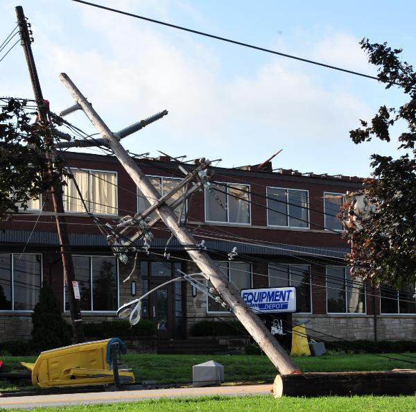
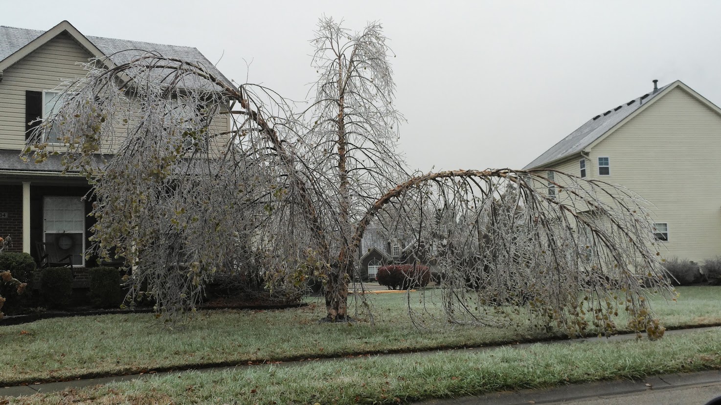
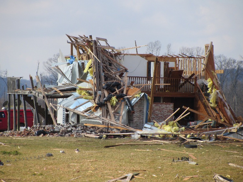 Damage west of Henryville in Clark County
|
|
|
Temperatures over southern Indiana and central Kentucky had soared well into the 70s by midday, with southern Kentucky setting record highs in the lower 80s ahead of an approaching cold front. The atmosphere became very unstable with extremely strong wind shear (the change in direction and speed of wind with height). The unstable, humid atmosphere would lead to storm development, and the wind shear would promote tornado development. The parent low of the system continued to deepen as it raced towards southern Michigan and dragged its attendant cold front into the Ohio and Tennessee Valleys. Storms erupted throughout the region. The result was eight tornadoes and many reports of large hail in southern Indiana and central Kentucky. The strongest wind shear maximized over southern Indiana, where twin supercells tracked from Dubois County to Trimble County. The lead supercell produced an EF4 tornado that stayed on the ground for 49 miles and caused 11 deaths. It was the region's strongest tornado since May 28, 1996 and the deadliest since the Brandenburg Tornado of April 3, 1974. Photo: NWS |
|
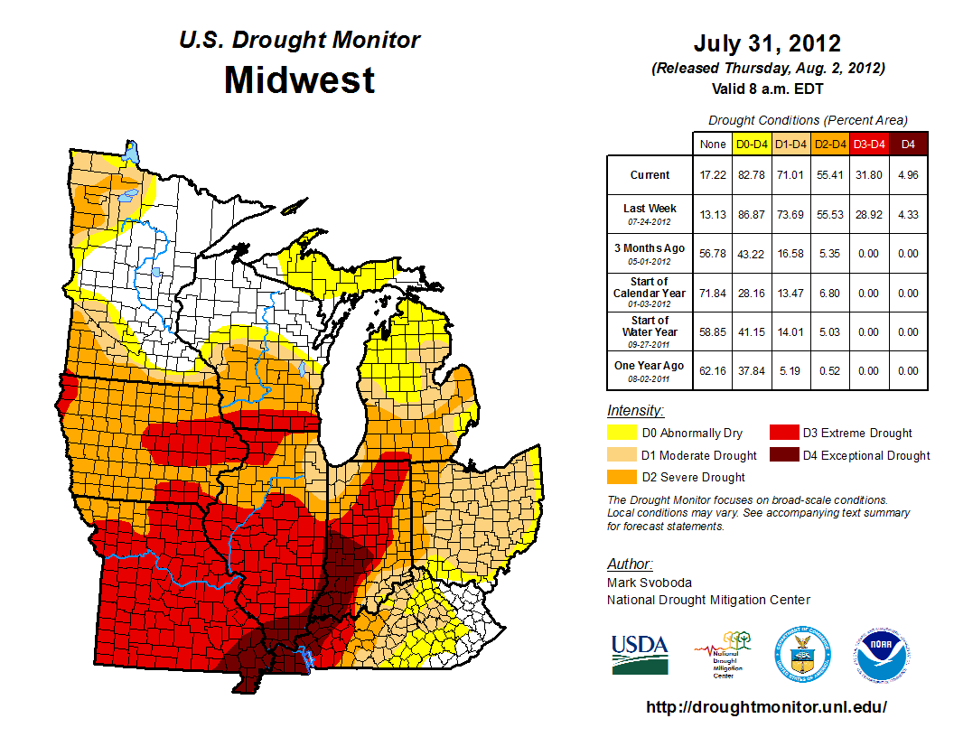
| 2. Exceptional (D4) Drought and Extreme Heat | |
| June - August 2012 | |
|
|
|
|
The worst heat of the summer of 2012 first hit in late June. Record highs over 100° were set each of the last three days of the month at Louisville and Bowling Green. On the 29th Bowling Green's temperature soared to 110°, breaking the old all-time record high for June of 108° set back in the Dust Bowl year of 1936. Louisville also set its all-time record high for June that day at 105°. The relentless heat continued into July, with record temperatures of 100° or more recorded somewhere in central Kentucky on 6 of the first 7 days of the month. Lexington and Louisville peaked at 105°, Bowling Green 106°. The morning low in Louisville on the 5th was a muggy 80°. July ended up being the hottest ever experienced in Louisville, and #2 in Lexington and Bowling Green. While there were occasional storms through the summer, the June-July heat wave baked the region and led to crippling drought, especially west of Interstate 65. Burn bans were in effect and agriculture suffered significantly, especially in southwest Indiana. By the second day of August 95% of Indiana's subsoil was short or very short of moisture. |
|
3. Derby Flood
|
|
May 1-2, 2010
|
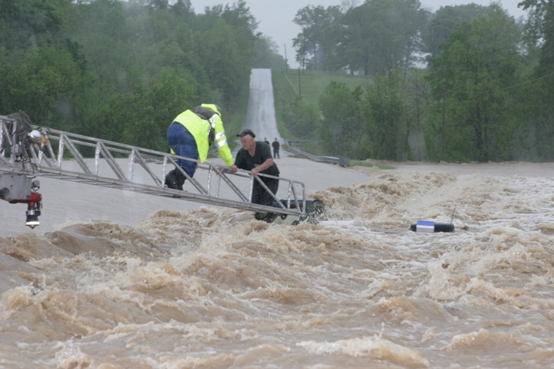 Swift water rescue in Allen County on May 2, 2010. The top of the victim's truck is just barely poking above the surface.
|
|
8 to 10 inches of rain inundated the region, especially from southern Kentucky into middle Tennessee, along a stationary front draped over the area. Atmospheric moisture was very deep and led to rainfall rates of 1 to 2 inches per hour. Impacts included flash flooding, rivers out of their banks, mudslides, a small dam failure, road closures, evacuations, and swift water rescues. In central Kentucky damage totaled $30 million and there were five fatalities. 9.67" of rain drenched Bowling Green setting a new 2-day rainfall record for the city.
|
|
March 4-6, 2015
|
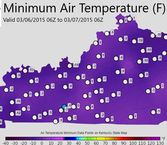 Low temperatures March 6, 2015
|
|
A slow-moving cold front brought waves of flooding rains March 4-5. Cold air coming in behind the front then turned the rain to snow. Due to the slow movement of the system, a band of very heavy snow, including thundersnow, set up from western to northern Kentucky, along and just south of the Ohio River. Final amounts were in the 18-24" range, including 17.1" at Lexington which broke the old 2-day March snowfall record by almost 7", and the city's all-time 2-day snowfall record (in any month) by almost 4". Louisville received 11.9" and Bowling Green 7.2". With the deep, fresh snow cover on the ground on the 5th, temperatures crashed that night. By the morning of the 6th Crab Orchard in Lincoln County was down to -12°, and Frankfort bottomed out at -10° which broke the old March all-time record low by 7 degrees. Lexington tied the record for March at -2°; only the 5th sub-zero temperature in March ever recorded in Lexington. |
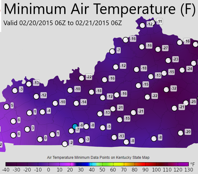
| 5. Heavy Snow, Intense Cold | |
| February 16-20, 2015 | |
|
Frosty weather February 17, 2015 |
|
|
On February 16 high pressure over the Great Lakes pulled cold air southward that interacted with moisture around low pressure traveling from Texas to North Carolina. Up to a foot of snow fell on central Kentucky with the heaviest amounts along and south of the Blue Grass and Western Kentucky Parkways. A weak cold front brought another 2-4" on the 18th, and then Arctic high pressure moved in over the fresh snowpack on the 19th and 20th. As the sun came up on the 20th the mercury plummeted to an astounding -23° at Cynthiana, -21° at Frankfort (#2 all-time coldest temperature) and -18° at Lexington (4th all-time coldest). Bowling Green fell to -7°, Louisville -6°. Photo: Wade Bell
Low temperatures February 20, 2015 |
|
| 6. 24 Tornadoes in 3 Hours | |
| April 19-20, 2011 | |
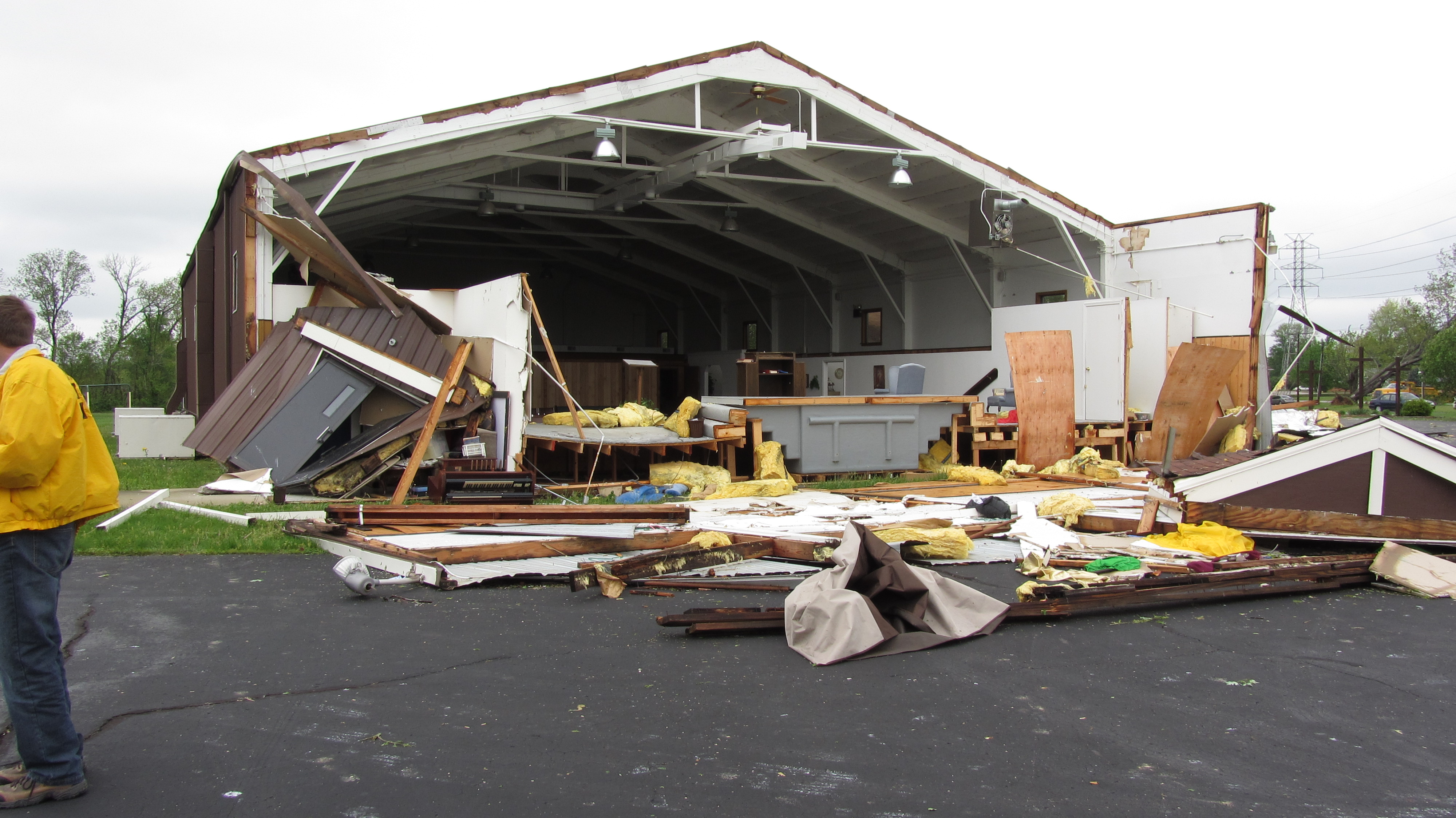
Dubois County tornado damage
|
|
|
A squall line erupted ahead of a cold front on the afternoon of the 19th from Illinois to Oklahoma. A low pressure center moving from Kansas to Ohio swung the cold front through the Ohio Valley that night. The squall line intensified as it moved eastward and became a prolific tornado producer. In southern Indiana and central Kentucky no fewer than 24 tornadoes touched down in only about three hours, between 11:22pm and 2:30am EDT. All but two of the tornadoes were north of Interstate 64. The strongest twisters were an EF2 in Dubois County near Bretzville and Saint Anthony, and an EF2 in Orange County at Roland. Even though the outbreak happened late at night when many people were asleep, there wasn't a single injury. Photo: NWS |
| 7. Churchill Downs/Louisville Metro Tornadoes |
|
June 22, 2011
|
Tornado damage near University of Louisville
|
|
A cold front approached the Ohio River during the late afternoon. Several storms developed to the west of Louisville and intensified as they moved east into the city. A very small, brief tornado touched down in Harrison County, Indiana, but the main event was in Jefferson County, Kentucky, where four more tornadoes formed, two of which attained EF2 strength. One of the EF2s damaged apartments and horse barns at Churchill Downs and a large industrial building near the University of Louisville's football stadium. Photo: Mike Dossett/KEMA |
| 8. 12-18" Snow, I-75 Closed | |
|
January 22-23, 2016
|
|
 Deep snow south of Upton, KY (Hart County) |
|
|
The first significant winter storm of the 2015-2016 winter season impacted much of Kentucky. A deepening low pressure system across the southern U.S. lifted copious amounts of moisture northward into the lower Ohio Valley where temperatures were in the teens and 20s. The combination of cold air and moisture brought a mix of snow, sleet, and freezing rain initially to southern Kentucky. Precipitation quickly changed over to moderate to heavy snow as several snow bands pivoted through the state. The heaviest snow fell from mid-morning until the mid-evening hours before tapering off around midnight. One to two feet piled up from near Glasgow and Munfordville east through Liberty and into eastern Kentucky. The snow resulted in very hazardous to impossible driving conditions, especially across central and eastern Kentucky. Portions of Interstate 75 south of Lexington were shut down as several accidents prevented road crews from clearing the interstate. Additionally, strong northeast winds resulted in areas of blowing and drifting snow, further hampering road clearing efforts. Widespread school and business closings were reported. Photo: Chasity Walters |
| 9. 5-8" Rain, Flood, Fire | |
|
April 2-3, 2015
|
|
|
Brownsboro Road in Louisville |
|
|
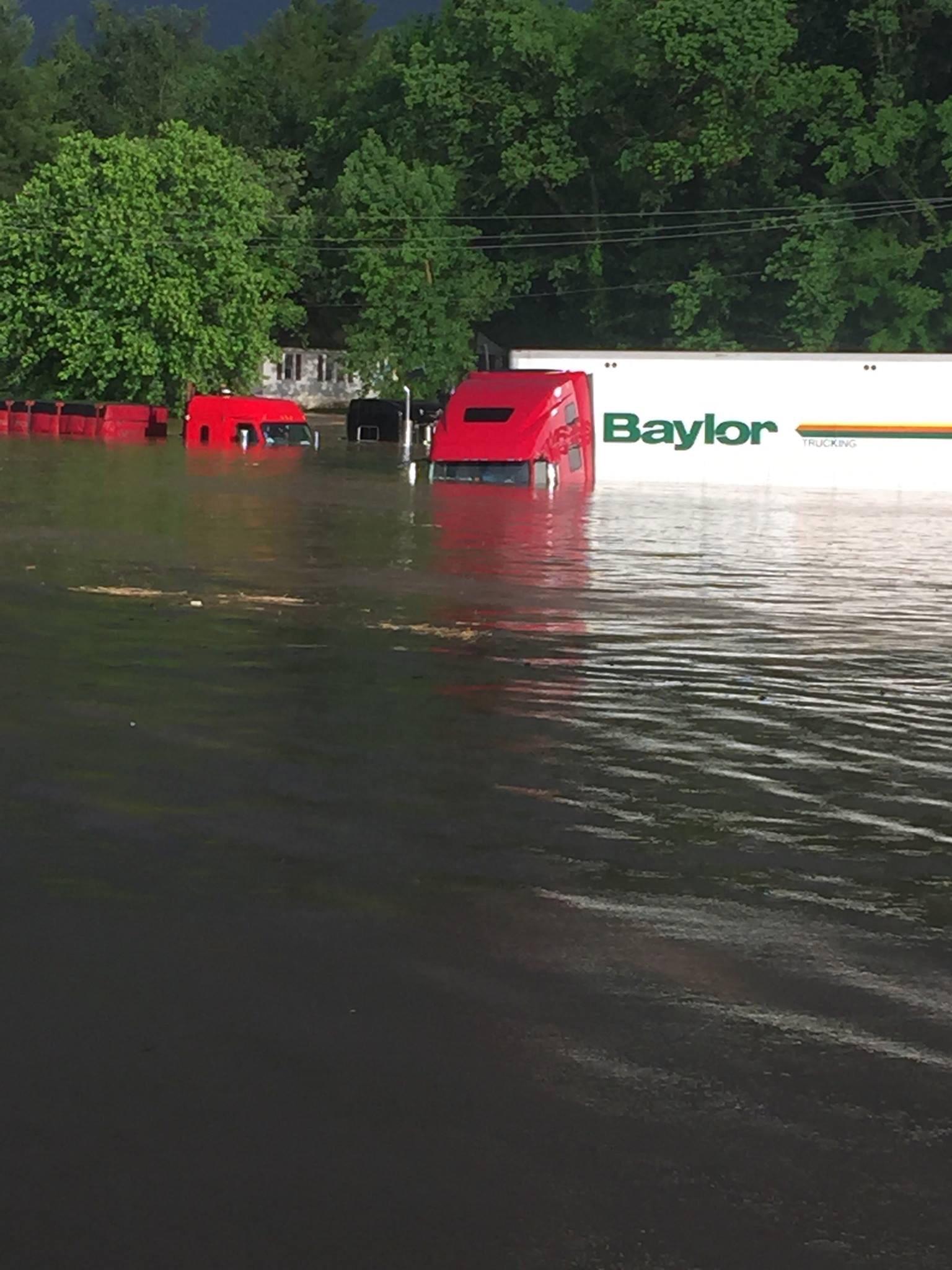
A stalled frontal boundary brought several rounds of showers and thunderstorms to the Ohio Valley. Storms during the afternoon and evening of the 2nd produced large hail and damaging winds. Training storms (multiple storms that follow one another over the same area) during the pre-dawn hours on April 3 resulted in flash flooding. Five to eight inches of rain fell, including 5.64" at Louisville for the city's 4th wettest calendar day on record (6.81" fell from the 2nd into the 3rd). The event garnered national media attention as over 160 water rescues took place in Louisville and several roads were washed out. To add to the disaster, a massive fire broke out at the General Electric Appliance Park in Louisville. Black smoke billowed into the sky and further stretched the resources of first responders. Photo: Joe Sullivan/NWS |
|
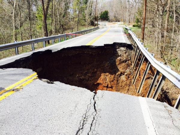
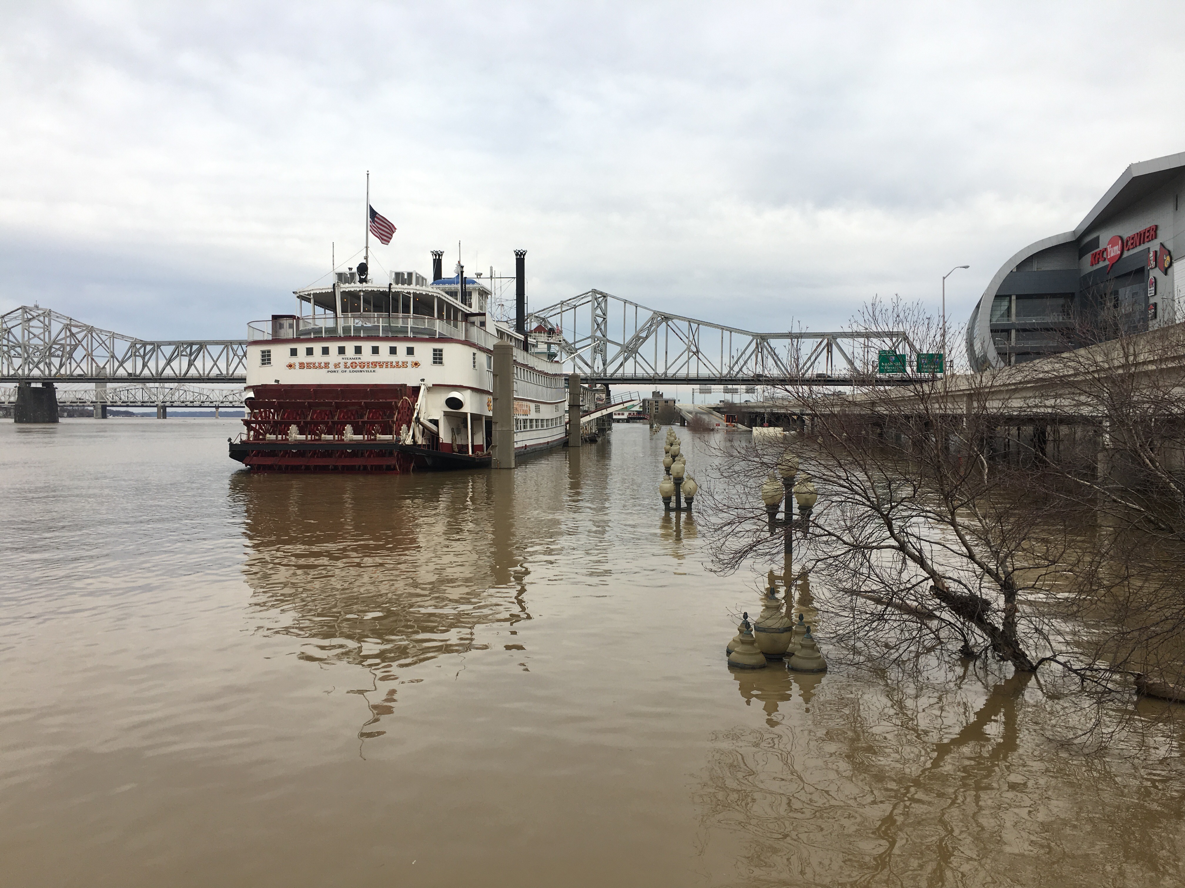
| February 25-27, 2018 |
|
|
|
Repeated rounds of moderate to heavy rainfall across the entire Ohio River basin totaled 8 to 9 inches along and on either side of the Ohio River from February 15 to March 1. These totals were 200 to 400% above normal for mid to late February. The large areal extent of the excessive rainfall led to significant rises on area rivers, including the Ohio River. This was the biggest flood on the Ohio River in Louisville since March 1997. The river reached its 7th highest stage on record at Cannelton (50.7') and Tell City (49.3'). The river attained the 10th highest level on record at McAlpine Upper in Louisville (35.6'). At Shepherdsville the Salt River peaked at 35', the 7th highest reading on record. Photo: NWS |
| 11. Flash Drought, Extreme Late-Season Heat | ||
| September-October 2019 | ||
 Incredible October heat |
||
|
After a very wet 2018 and first half of 2019, the rains became much less frequent starting in early July. By September drought had developed across the region, culminating as a Severe Drought (D2) across most of central Kentucky and extreme southern Indiana. At its peak on October 1 cyanotoxins and algal blooms were discovered in the Ohio River, causing Ironman Louisville to cancel the swimming portion of the competition. 109 of Kentucky's 120 counties were under burn bans, including Fayette County. The Kentucky River in the Blue Grass was reduced to less than 10% of its normal flow. Of the Kentucky Mesonet's 71 stations, 31 of them received less than a tenth of an inch of rain in September. In Lexington September 2019 was the first calendar month since records began in 1872 in which no measurable rain fell. The city's record for longest stretch without measurable rain was also set, at 39 days, ending on October 5. Drought begets heat. Louisville recorded 22 days in September with temperatures in the 90s and Lexington experienced 19 such days -- both new records for the month. The first three days of October were like none ever seen before in the month. Afternoon temperatures were in the middle to upper 90s each day. Louisville and Lexington set new all-time record highs for October with 97°, and Bowling Green did the same when the city hit 98°. |
| 12. Unusual Ice Storm | |
| November 14-15, 2018 | |
|
|
|
|
A cold air mass in place combined with a low pressure system to produce an early season freezing rain event across central Kentucky and southern Indiana. Many locations received between a tenth and a quarter of an inch of ice accumulating on trees/shrubs and other elevated surfaces. Warm ground temperatures kept most roads ice-free, though some bridges had slick spots. The ice on the trees, many of which still had leaves that helped to weigh them down, caused several limbs/branches to snap and some trees to fall. There were many reports of power flashes as branches hit transformers. At the peak of the event, over 100,000 customers were without power in the region. It was the region's first freezing rain event in November since 1989. Photo: NWS |
| June 26, 2018 | |
|
Tornado damage in Worthington Hills, Kentucky |
|
|
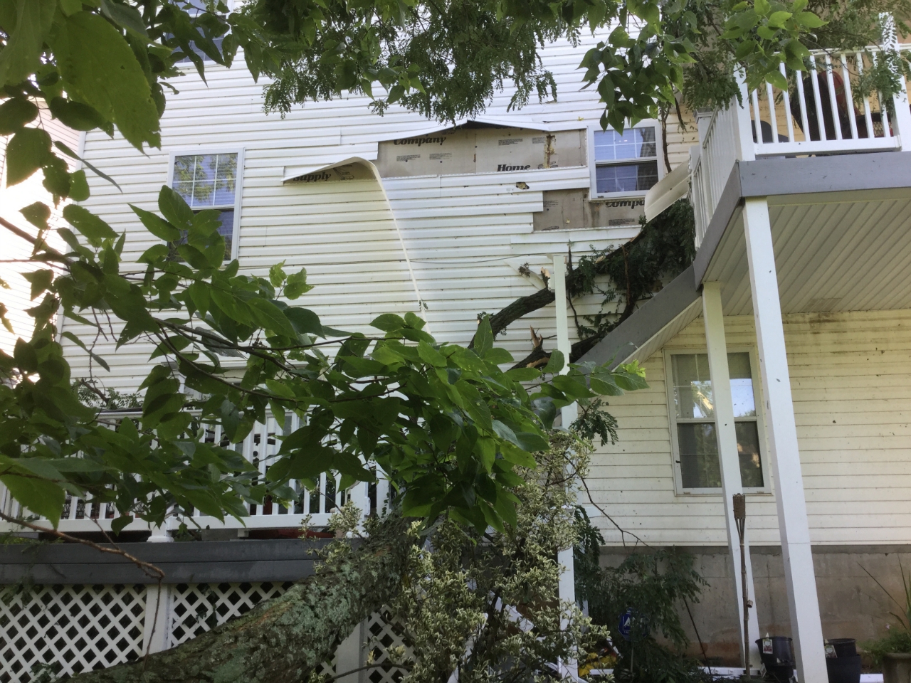
It was a small tornado but it touched down in a heavily populated area of east Louisville with mixed uses including single family homes, apartment buildings, and commercial properties. There was widespread roof, tree, and wall damage, and several large businesses were hit or just barely missed. The storm raised awareness of the responsibility business owners have toward the protection of their employees during severe weather. The tornado gained strength as it moved across the south edge of Pewee Valley, doing significant damage to trees. Photo: NWS |
|
|
February 28, 2011
|
|
 A destroyed barn in Boyle County |
|
|
One of five late winter tornadoes on this day. The tornado touched down just to the southwest of KY 1899 (Mulberry Pike) and crossed into Springhill Estates subdivision. Two homes were destroyed along with three outbuildings. Trees were uprooted and snapped. Fifteen power poles were blown down along KY 1359. One barn was destroyed and another had the roof blown off. The tornado continued across KY 22 where trees were blown down and one outbuilding was damaged. The tornado lifted near Drennon Creek. The storm caused one injury. Peak winds were around 140 mph. Photo: NWS |
| 15. Salem, Indiana Flash Flood Emergency | |
| May 19, 2017 | |
 Severe flooding in Salem, Indiana |
|
|
An extremely warm, moist, and unstable air mass resided over the lower Ohio Valley during the middle of May. As a series of strong weather systems passed through the region, rounds of strong to severe thunderstorms developed and tracked across southern Indiana. Several inches of rain fell in a very short time resulting in a significant flash flood event in Washington County. Multiple high water rescues were performed. The West Fork of the Blue River in Salem hit a record crest of 20.2', surpassing the old record by about three feet. Photo: Rosy Callahan |


 Weather Story
 Weather Map
 Local Radar