Structure and Evolution of Squall Lines and Bow Echoes
A "squall line" refers to a linearly-oriented zone of convection (i.e., thunderstorms). Squall lines are common across the United States east of the Rockies, especially during the spring when the atmosphere is most "dynamic." A "bow echo" or "bowing line segment" is an arched/bowed out line of thunderstorms, sometimes embedded within a squall line. All these terms fall under the more generic term Quasi-Linear Convective System (QLCS). Bow echoes, most common in the spring and summer, usually are associated with an axis of enhanced winds that create straight-line wind damage at the surface. In fact, bow echo-induced winds/downbursts account for a large majority of the structural damage resulting from convective non-tornadic winds. Transient tornadoes also can occur in squall lines, especially in association with bow echoes. These tornadoes, however, tend to be weaker and shorter-lived on average than those associated with supercell thunderstorms. Severe squall lines and bow echoes are quite common in the Ohio Valley, including Kentucky. A sequence of WSR-88D Doppler radar images and discussions from some squall line/bow echo events across Kentucky and south-central Indiana are available to complement this document. Detailed squall line and bow echo information is given below, including pre-storm environments, and WSR-88D radar reflectivity, velocity, and mesocyclone characteristics.
PRE-STORM ENVIRONMENTS ASSOCIATED WITH SQUALL LINES/BOW ECHOES
Warm Season Events (Summer; Weak Synoptic Forcing)
- SURFACE PATTERNS
- Generally east-west frontal boundary (genesis area frequently north of front).
- Strong surface convergence (near genesis area).
- High dewpoints pooled near front/genesis area; maximum values just south of front.
- Surface equivalent potential temperature (theta-e) values very high along derecho track.
- Bow echo often moves parallel to front with slight component toward warm sector.
- UPPER-LEVEL PATTERNS
- Straight or anticyclonically curved mid/upper-level flow near a ridge axis.
- Weak shortwave trough located near/upstream from genesis region.
- Moderate/strong warm advection at 850 and 700 mb present near genesis area with weaker advection downwind. Neutral or weak cold advection noted in mid/upper levels over and downwind of genesis area.
- 850 mb moisture very high and pooled just south of bow echo track; drier air can be present at 700 and 500 mb enhancing damaging wind potential.
- Bow echo moves generally along 850 and 700 mb thermal gradient (along or north of thermal/theta-e ridge axis).
- THERMODYNAMIC AND VERTICAL WIND SHEAR PROFILE
- Long-lived warm season bow echo events associated with very unstable air mass.
- Average maximum convective available potential energy (CAPE) values in genesis area roughly 2400 J/kg with even greater instability downwind where average maximum CAPE is about 3500-4000 J/kg (range of 2500-6000 J/kg).
- Extreme instability due to pooling of moisture near front, so surrounding upper-air soundings may be unrepresentative of true local instability.
- Winds at 850 and 700 mb show good directional shear (veering) near genesis area, and often mainly speed shear parallel to storm track downwind.
Cool Season Events (Late Winter/Spring Strong Dynamic Forcing)
- SURFACE PATTERNS
- Strong, progressive low pressure system and associated warm and cold fronts.
- Squall line with embedded bowing line segments often located along or north of warm front southward across warm sector along or ahead of cold front.
- UPPER-LEVEL FEATURES
- Moderate/strong wind fields throughout atmosphere; 850 mb wind speeds 30-60 kts common with upper-level jet stream axis aloft nearby (often north and/or west of squall line).
- Wind fields stronger than in warm season bow echo events.
- Significant divergence/convergence fields and dynamical forcing (to produce strong lift) associated with convective development which overcomes possible limited moisture and instability.
- Environmental wind momentum aloft may transfer downward causing damaging surface winds, especially if no low-level inversion present.
- THERMODYNAMIC AND VERTICAL WIND SHEAR PROFILE
- Cool season squall lines/bow echoes often associated with less instability than for warm season events.
- Degree of instability varies widely. CAPE values vary from less than 500 J/kg to over 2000 J/kg. Strong forcing/vertical shear compensates for limited instability.
- Layer of dry, potentially cold air (or cold advection/backing winds) often present in mid-level downdraft entrainment area (3-7 km layer) which impinges on squall line from upstream side, thereby enhancing damaging wind potential.
- Cool season squall lines/bow echoes associated with moderate/strong wind shear within the lowest 2.5 km layer (surface to 850 or 700 mb).
- Optimal conditions for bow echoes: linear shear profile with strong SPEED (limited directional) shear of 50 kts within lowest 2.5 km of atmosphere with minimal shear aloft.
TWO BASIC PATTERNS OF SQUALL LINE/BOW ECHO CONVECTIVE SYSTEMS
Progressive: Length of squall line/bow echo relatively short and curved, and oriented perpendicular to mean environmental wind. Line bulges/bows downwind which is associated with downburst activity. Warm season bow echoes associated with high instability and an east-west surface front often exhibit a progressive pattern.
Serial: Length of squall line/bow echo usually extensive (much longer than progressive type) and oriented nearly parallel to mean environmental wind direction. Within squall line, a series of line echo wave patterns (LEWPs) and bow echoes often occur, resulting in damaging winds and possible transient tornadoes. High precipitation (HP) supercell characteristics sometimes can occur within organized, long-lived bowing line segments within serial squall lines. Dynamically-induced cool season events often exhibit a serial pattern.
REFLECTIVITY CHARACTERISTICS:
- During a bow echo's incipient stage, a strong downburst may descend within or on the rear flank of the convective echo, resulting in an initial bulging echo pattern.
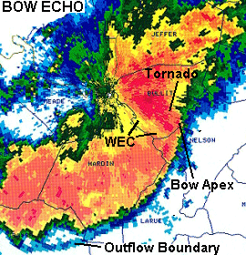
- Bow echoes exhibit a bulging/bowing of the reflectivity gradient forward/downwind from the rest of the squall line. Usually, a strong low-level reflectivity gradient is present on the leading edge of intense convection indicating strong convergence and a vertical updraft. See images below.
- Subtle weak echo regions (WERs) may be present on the leading edge of the reflectivity gradient marking the location of significant storm-relative inflow and the updraft zone.
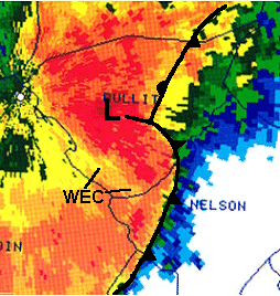
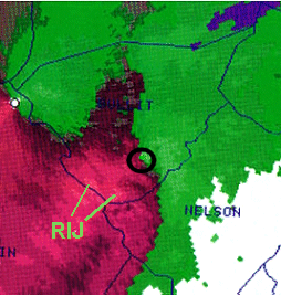
- Rear inflow notches (RINs)/weak echo channels (WECs) frequently are noted behind the leading intense convection, which usually are co-located with local enhancements in the rear inflow jet (RIJ). See images below.
- Within an overall serial-type squall line, there may be several bowing echo segments embedded.
- Bow echoes often are associated with significant damaging surface winds (assuming a well-mixed boundary layer) near the apex of the bow (i.e., along the RIJ), and possible non-supercell tornadoes along or north (cyclonic side) of the apex.
- The leading convective line remains intense if the low-level cold pool beneath the convection balances the ambient vertical wind shear, so that the outflow boundary and intense updrafts remain on the leading edge of the convective line. An outflow boundary propagating ahead of the line may initiate new cells downwind but will eventually diminish updrafts and the intensity within the main line.
- There may or may not be a relatively large "stratiform" precipitation area (albeit still some thunder and lightning) behind the leading convective line depending on the amount of storm-relative elevated front-to-rear flow. Squall lines that exhibit significant stratiform rainfall behind the entire length of the line are referred to as symmetric, while those with significant trailing rainfall only with the northern portion of the line are referred to as asymmetric. Serial-type "cool season" squall lines usually are associated with more training stratiform precipitation than progressive "warm season" events.
VELOCITY CHARACTERISTICS:
- Mid-altitude radial convergence (MARC) signature may be evident in WSR-88D storm-relative velocity map (SRM) data at an altitude of about 3-7 km. Strong (over 50 kts; 25 m/s), persistent, deep-layered radial velocity differences (Vin + Vout along similar radials, i.e., MARC) within an area of convection can signify entrainment of environmental air that can enhance negative buoyancy through evaporation, resulting in downdraft acceleration, i.e., a downburst. Rear inflow in the system coupled with substantial MARC can accentuate the downburst. This causes the onset of damaging surface winds and the development of a low-level bow structure in reflectivity data. However, wind damage can occur before significant low-level bowing appears. Thus, the identification of spatially and temporally coherent MARC in convective systems is crucial to anticipating subsequent wind damage. MARC can precede the onset of surface wind damage by up to 15-20 minutes. MARC is also very useful in anticipating possible microbursts associated with severe pulse storms. Decreasing WSR-88D vertically integrated liquid (VIL) values in conjunction with significant MARC may signify a collapsing storm that is about to produce a downburst.
- Local enhancements in the rear inflow jet (RIJ) tend to develop along and behind axes of bowing line segments, especially those associated with significant trailing stratiform precipitation. Convective downdrafts can intensify wind flow and damage associated with RIJs along the leading bow apex. See images above.
- If the ambient wind shear is moderate-to-strong, the RIJ tends to remain elevated up to near the leading edge of the bow echo, then rapidly descends at the updraft/downdraft interface causing significant wind damage. Systems with elevated RIJs tend to be long-lived with rapid multicell growth along the leading edge of the system.
- If the ambient shear is weak, the RIJ tends to descend and spread out along and behind the leading line, still with possible wind damage but less intense/shorter-lived than for stronger sheared MCSs.
- Squall lines often contain two main airflow streams relative to the moving convective system. The first stream is rear-to-front associated with the RIJ. Above this stream is storm-relative front-to-rear flow. This stream has warm, moist origins ahead of the squall line, rises up rapidly within the leading convection, then exhibits a much more gently sloped ascent behind the line resulting in trailing stratiform precipitation.
MESOVORTEX CHARACTERISTICS:
- Cyclonic circulation (mesovortex) formation and possible tornadogenesis within squall lines usually occur in association with bowing line segments given sufficient forcing, instability, and wind shear.
- For leading line (bow echo) tornadoes, the initial circulation typically develops as an area of enhanced cyclonic-convergence in the lower portions of the storm along/just north of the bow apex, then rapidly intensifies and deepens in altitude, partly due to rapid vertical stretching in the updraft. The circulation may be wrapped within precipitation. The vortex eventually broadens and weakens as it propagates rearward with respect to the leading line. Tornado occurrence is most likely during the intensifying and deepening stage, when tight shears and strongest rotational velocities exist. Some mesovortices can deepen and be of strength to rival mesocyclones. See images above.
- Tornadoes sometimes can be tucked within a subtle weak echo region (WER) on the front forward flank of an organized bow containing high precipitation (HP) supercell characteristics. Tornadoes also are possible within moderate-to-heavy precipitation under or near a rapidly rotating comma head reflectivity signature.
- Convective cell or boundary interactions with bow echoes may further enhance convergence and vertical stretching allowing for more rapid development and spin-up of mesovortices/cyclonic circulations.
- Vortex evolution along an organized, long-lived bow echo can be cyclic, i.e., the initial circulation develops and intensifies, propagates along the bow, and eventually weakens. However, new circulations can develop quickly along the bow apex just to the south and/or east of the initial vortex go through the same life cycle. This can result in a series/family of transient tornadoes.
- Tornadoes associated with bow echoes frequently are relatively short-lived and usually of EF0-EF2 intensity. Tornadic damage usually is embedded within and/or on the northern fringe of straight-line wind damage associated with the bow apex and rear inflow jet. While tornado damage within bow echoes can be significant, the large majority of damage from bow echoes is from straight-line winds. Maximum wind damage also often occurs along the path of mesovortices.
In the severe weather warning process for squall lines and bow echoes, knowledge of the environment and accurate and timely assessment of WSR-88D reflectivity and velocity structure is crucial. Reflectivity is used to delineate those locations for greatest potential for damaging straight-line winds and tornadoes. Certain reflectivity structures typically are associated with very strong surface winds and tornadoes. Velocity (base and storm-relative) data also is used to evaluate straight-line wind potential and mesovortex evolution.
Back to Training Documents


 Weather Story
 Weather Map
 Local Radar