After an extremely wet September across southern Indiana and north central Kentucky, in October the axis of the heavy rains shifted south. Greater than normal rainfall amounts were reported from the Bowling Green region east to Lake Cumberland and northeast into the southern Blue Grass counties. Fayette, Nicholas, and Madison counties were especially wet. On the 4th a localized downpour dropped almost three and a half inches of rain on Blue Grass Field. Meanwhile, southern Indiana received less than half of the rain it normally sees during the first 30 days of October. Much of southern Indiana's deficit was made up with heavy rain on the 31st, especially in the counties along the Ohio River.
The first week and a half of the month was unusually warm, especially at night. Each day from the 1st to the 10th was 10-20 degrees warmer than normal. On the 11th a cold front swept through the region and ushered in a much cooler regime for the remainder of the month.
The only severe weather occurred about six and a half hours before the month ended when a small EF-1 tornado damaged homes just south of Rineyville in Hardin County.
| Average Temperature | Departure from Normal | Precipitation | Departure from Normal | |
| Bowling Green | 61.2° | +2.4° | 5.12" | +1.74" |
| Frankfort | 59.2° | +2.8° | 5.27" | +2.03" |
| Lexington | 59.6° | +2.5° | 7.35" | +4.22" |
| Louisville Bowman | 61.3° | +3.1° | 2.45" | -0.77" |
| Louisville International | 61.5° | +2.0° | 2.79" | -0.43" |
Records
2nd: Warm low of 70° at Frankfort, warm low of 69° at Lexington, warm low of 73° at Louisville
4th: Warm low of 70° at Lexington, rainfall of 3.42" at Lexington
5th: Warm low of 71° at Lexington (also record warm low for the month of October)
6th: Warm low of 68° at Frankfort
7th: Warm low of 70° at Lexington, warm low of 70° at Louisville
8th: Warm low of 66° at Bowling Green, warm low of 68° at Frankfort, warm low of 70° at Lexington, warm low of 72° at Louisville
9th: Warm low of 70° at Lexington, warm low of 72° at Louisville
10th: Warm low of 70° at Bowling Green, warm low of 70° at Lexington, warm low of 71° at Louisville
13th: Cold high of 55° at Bowling Green, cold high of 49° at Frankfort
14th: Rainfall of 1.62" at Bowling Green
15th: Rainfall of 1.58" at Bowling Green
31st: Rainfall of 2.82" at Frankfort
Third wettest October on record at Lexington
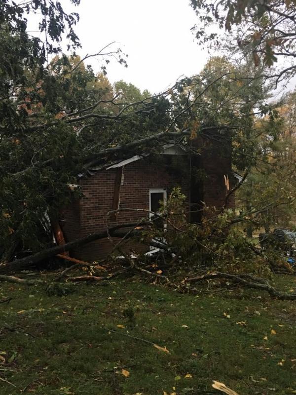
Storm damage near Rineyville on Halloween. Photo courtesy Shelly Keeney.


 Weather Map
 Local Radar