Louisville, KY
Weather Forecast Office
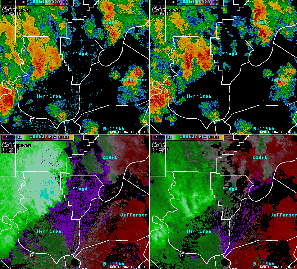 |
Different radar products can be displayed in a 4-panel layout to assess storm structure. In the image, the top 2 panels show reflectivity data at 2 different elevation angles. The bottom panels show base velocity at the same 2 levels as in reflectivity at top. Thus, 2 different products at 2 different levels are displayed. Another product called All-Tilts can quickly show all radar elevation angles of reflectivity and velocity to provide the best storm analysis. In this event, thunderstorms over Harrison County, IN moved southeast on July 10, 2013. Velocity data showed winds over 60 kts (around 70 mph) at 2000-3000 ft off the ground over northern Harrison (light blue color in bottom left panel) associated with these storms. Winds were a little lighter around 6000 ft up (bottom right panel). The storms produced several reports of wind damage as they moved across Louisville and Jefferson County, KY shortly after this time. |
Current Hazards
Hazardous Weather Outlook
Storm Prediction Center
Submit a Storm Report
Advisory/Warning Criteria
Radar
Fort Knox
Evansville
Fort Campbell
Nashville
Jackson
Wilmington
Latest Forecasts
El Nino and La Nina
Climate Prediction
Central U.S. Weather Stories
1-Stop Winter Forecast
Aviation
Spot Request
Air Quality
Fire Weather
Recreation Forecasts
1-Stop Drought
Event Ready
1-Stop Severe Forecast
Past Weather
Climate Graphs
1-Stop Climate
CoCoRaHS
Local Climate Pages
Tornado History
Past Derby/Oaks/Thunder Weather
Football Weather
Local Information
About the NWS
Forecast Discussion
Items of Interest
Spotter Training
Regional Weather Map
Decision Support Page
Text Products
Science and Technology
Outreach
LMK Warning Area
About Our Office
Station History
Hazardous Weather Outlook
Local Climate Page
Tornado Machine Plans
Weather Enterprise Resources
US Dept of Commerce
National Oceanic and Atmospheric Administration
National Weather Service
Louisville, KY
6201 Theiler Lane
Louisville, KY 40229-1476
502-969-8842
Comments? Questions? Please Contact Us.


 Weather Story
 Weather Map
 Local Radar