Louisville, KY
Weather Forecast Office
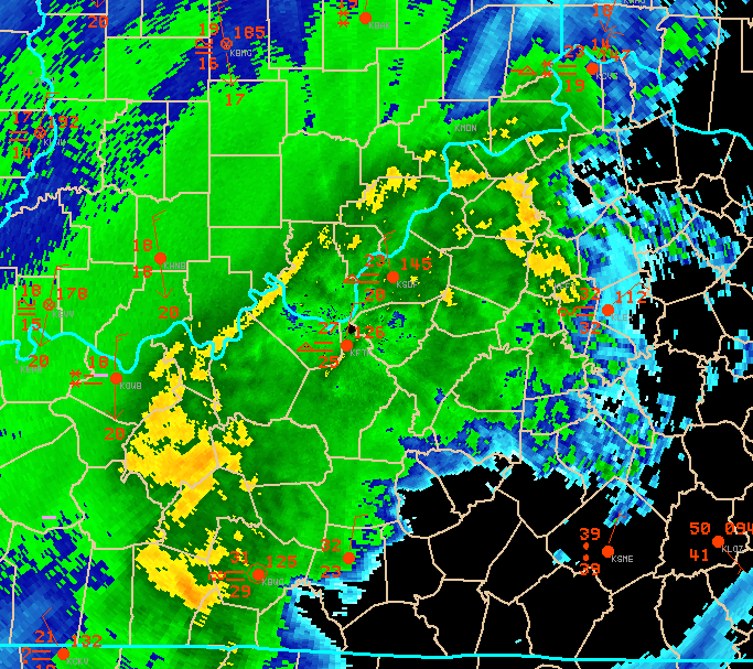 |
NWS Doppler radar base reflectivity data shows where and how hard it is raining or snowing, as well as precipitation intensity trends and movement. The image shows 0.5 degree base reflectivity data from the December 22-23, 2004 major winter storm over central Kentucky and southern Indiana. Overlaid on radar are surface observations in red. Over southern Indiana, green colors represented moderate to heavy snow, while the narrow band of yellow in far southern Indiana just north of the Ohio River (blue line) was an axis of very heavy snow with large snowflakes. This band remained nearly stationary for several hours. Coupled with snow earlier in the day, total snowfall amounts in southern Indiana from the storm ranged from 1 to 3 feet, with higher drifts! Thunder snow also occurred (thunderstorm producing snow). In north-central Kentucky (including Louisville), moderate to heavy precipitation in the form of sleet and some snow was occurring at this time. Farther south, freezing rain accumulated, while little or no precipitation was falling at this time over parts of south-central Kentucky (area of black). |
Current Hazards
Hazardous Weather Outlook
Storm Prediction Center
Submit a Storm Report
Advisory/Warning Criteria
Radar
Fort Knox
Evansville
Fort Campbell
Nashville
Jackson
Wilmington
Latest Forecasts
El Nino and La Nina
Climate Prediction
Central U.S. Weather Stories
1-Stop Winter Forecast
Aviation
Spot Request
Air Quality
Fire Weather
Recreation Forecasts
1-Stop Drought
Event Ready
1-Stop Severe Forecast
Past Weather
Climate Graphs
1-Stop Climate
CoCoRaHS
Local Climate Pages
Tornado History
Past Derby/Oaks/Thunder Weather
Football Weather
Local Information
About the NWS
Forecast Discussion
Items of Interest
Spotter Training
Regional Weather Map
Decision Support Page
Text Products
Science and Technology
Outreach
LMK Warning Area
About Our Office
Station History
Hazardous Weather Outlook
Local Climate Page
Tornado Machine Plans
Weather Enterprise Resources
US Dept of Commerce
National Oceanic and Atmospheric Administration
National Weather Service
Louisville, KY
6201 Theiler Lane
Louisville, KY 40229-1476
502-969-8842
Comments? Questions? Please Contact Us.


 Weather Story
 Weather Map
 Local Radar