Louisville, KY
Weather Forecast Office
 |
|
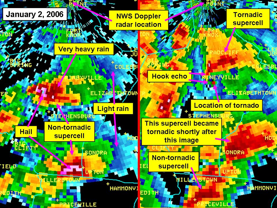
NWS Louisville reflectivity images of supercell thunderstorms over Hardin, northern Hart, and western Larue counties in central Kentucky on January 2, 2006. The radar is at Ft. Knox at the top of the images. Heavy rain and hail occurred from many of the storms. A tornado also developed from the cell in central Hardin. The storm was non-tornadic in the far left image, but a short time later had a tornado on the ground at the small red dot in the storm's hook echo near Rineyville (near left image). This event occurred in early January. Severe weather and tornadoes can occur in any month of the year across the Ohio Valley, and is referred to as "cool season severe weather." If enough warm, moist air is drawn northward from the Gulf of America ahead of a strong low pressure system to the west, then severe storms can erupt which are supported by moderate or strong wind shear in the atmosphere. |
Current Hazards
Hazardous Weather Outlook
Storm Prediction Center
Submit a Storm Report
Advisory/Warning Criteria
Radar
Fort Knox
Evansville
Fort Campbell
Nashville
Jackson
Wilmington
Latest Forecasts
El Nino and La Nina
Climate Prediction
Central U.S. Weather Stories
1-Stop Winter Forecast
Aviation
IDSS Forecast Points
Air Quality
Fire Weather
Recreation Forecasts
1-Stop Drought
Event Ready
1-Stop Severe Forecast
Past Weather
Climate Graphs
1-Stop Climate
CoCoRaHS
Local Climate Pages
Tornado History
Past Derby/Oaks/Thunder Weather
Football Weather
Local Information
About the NWS
Forecast Discussion
Items of Interest
Spotter Training
Regional Weather Map
Decision Support Page
Text Products
Science and Technology
Outreach
LMK Warning Area
About Our Office
Station History
Hazardous Weather Outlook
Local Climate Page
Tornado Machine Plans
Weather Enterprise Resources
US Dept of Commerce
National Oceanic and Atmospheric Administration
National Weather Service
Louisville, KY
6201 Theiler Lane
Louisville, KY 40229-1476
502-969-8842
Comments? Questions? Please Contact Us.


 Weather Story
 Weather Map
 Local Radar