Louisville, KY
Weather Forecast Office
Ice accumulation from freezing rain does not coat the surface of objects evenly. Gravity will usually cause the rain water to run to the underside of an object before it freezes. Wind can create the same effect. In either case, the result would be a thicker coating of ice on one side of the object compared to the opposite side.
You can accurately estimate the thickness of the ice with the method below. You will need a ruler and possibly a piece of paper and pencil.
1. Locate an ice-covered object that is out in the open. A small tree branch in the middle of the yard is usually easiest to handle.
2. Move to a position where you can see both the thickest and thinnest portions of ice coating the object from one side to the other.
3. Using the ruler, measure the thickest part of the ice, from the edge of the object to the edge of the ice. Record that value on your paper.
4. Similarly, measure the thinnest part of the ice, from the edge of the object to the edge of the ice. Record that value on your paper.
5. Add the two values together and then divide by two. The resulting value is your ice accumulation.
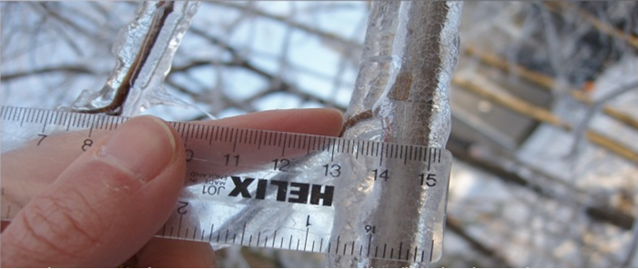
In the example below, the ice thickness on the left side of the branch is about 5/16" thick, and the thickness on the right side is about 3/16" thick (using the marks on the bottom of the ruler). Add those two numbers together and divide by two to get the average thickness of 4/16"...or about a quarter inch of ice.

A great way to report ice to the National Weather Service is to send us a Tweet (@NWSLouisville). You may also fill out our Storm Report Form, post a message on our Facebook page, or if it's during the week between 8am and 6pm EST just give us a call at (502) 969-8842. When you report your ice thickness, be sure to let us know if you measured it on a round surface like a tree branch or on a flat surface like a deck or sidewalk. Of course, be sure to tell us your location, too!
Current Hazards
Hazardous Weather Outlook
Storm Prediction Center
Submit a Storm Report
Advisory/Warning Criteria
Radar
Fort Knox
Evansville
Fort Campbell
Nashville
Jackson
Wilmington
Latest Forecasts
El Nino and La Nina
Climate Prediction
Central U.S. Weather Stories
1-Stop Winter Forecast
Aviation
Spot Request
Air Quality
Fire Weather
Recreation Forecasts
1-Stop Drought
Event Ready
1-Stop Severe Forecast
Past Weather
Climate Graphs
1-Stop Climate
CoCoRaHS
Local Climate Pages
Tornado History
Past Derby/Oaks/Thunder Weather
Football Weather
Local Information
About the NWS
Forecast Discussion
Items of Interest
Spotter Training
Regional Weather Map
Decision Support Page
Text Products
Science and Technology
Outreach
LMK Warning Area
About Our Office
Station History
Hazardous Weather Outlook
Local Climate Page
Tornado Machine Plans
Weather Enterprise Resources
US Dept of Commerce
National Oceanic and Atmospheric Administration
National Weather Service
Louisville, KY
6201 Theiler Lane
Louisville, KY 40229-1476
502-969-8842
Comments? Questions? Please Contact Us.


 Weather Story
 Weather Map
 Local Radar