|
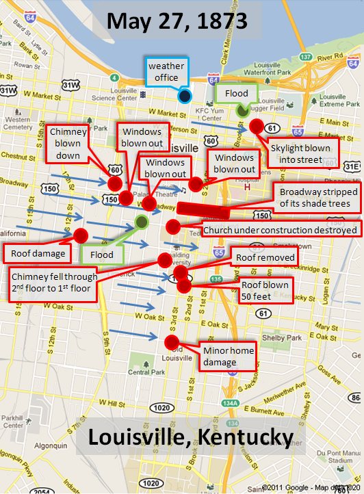
This storm struck Louisville with alarming suddenness as blue sky was quickly replaced by a rapidly developing thunderhead that exploded to life just west of town. As the storm moved east, rain, hail, and lightning hit "all at once" between 1 and 2 o'clock in the afternoon according to reports. Hailstones were as large as pigeons' eggs (about an inch and a half across). Prodigious lightning was also observed, and several chimneys were struck and damaged. The lightning was described as "unusually brilliant and of long duration" and the thunder shook houses like an earthquake. Although newspaper articles called this event a "fierce tornado," the damage was more likely the result of very strong straight-line winds, possibly the result of a wet downburst. If there were any small tornadic spin-ups, the most likely location was along Broadway between Ninth and Brook. The avenue was "stripped of shade trees" between Fourth and Brook. The home of Mr. and Mrs. L. B. Porch on Fourth Street was badly damaged when the winds struck the home from the west. The chimney fell through the roof, through the second floor narrowly missing Mrs. Porch, landing on the first floor. About a thousand dollars (1873) damage was done. At Floyd and Market a skylight covering was thrown from a building onto a streetcar full of passengers in the street below. Fortunately no one was hurt. In addition to the widespread wind damage, flash flooding was severe. The streets "ran like rivers" according to news reports. The water was knee deep on York Street between Sixth and Seventh "to the great pleasure of local schoolboys" and was deep and swift enough that logs were witnessed floating down the street. At Brook and Main the flooding was so bad it caused a building that was under construction to collapse. There were no fatalities or injuries from the sudden storm. The heart of the storm missed the weather office, but the office did measure 1.32" of rain. |
|
 |
|