Louisville, KY
Weather Forecast Office
The first week and a half of June was characterized by seasonable temperatures and frequent rains. Central Kentucky and southern Indiana received rainfall on nine of the first eleven days of the month.
Active weather continued mid-month with scattered severe storms each day from the 11th to the 13th, mostly resulting in tree and power line damage. The official weather observing equipment at Frankfort recorded a 66 mph wind gust on the 11th!
On the night of June 18-19 torrential rains fell across much of central Indiana, southwestern Ohio, and northern Kentucky. The Madison, Indiana area reported 3 to 7 inches of rain. Severe flash flooding up to 5 feet deep led to the evacuation of 35 residents. Sixty buildings were damaged. After the water receded, 80 tons of debris was removed.
After a pleasant day on the 22nd with afternoon temperatures in the 70s, heat slowly built across the region. By the 27th-29th temperatures were back into the 90s. Louisville hit 97° on the 29th.
| Average Temperature | Departure from Normal | Precipitation | Departure from Normal | |
| Bowling Green | 77.1° | +1.0° | 2.78" | -1.73" |
| Frankfort | 74.7° | +1.0° | 5.42" | +1.08" |
| Lexington | 72.6° | -0.7° | 6.70" | +1.74" |
| Louisville Ali | 77.8° | +1.4° | 4.49" | +0.22" |
| Louisville Bowman | 76.5° | +1.0° | 2.80" | -1.88" |
Records
8th: Rainfall of 1.75" at Frankfort
25th: Warm low of 75° at Bowling Green
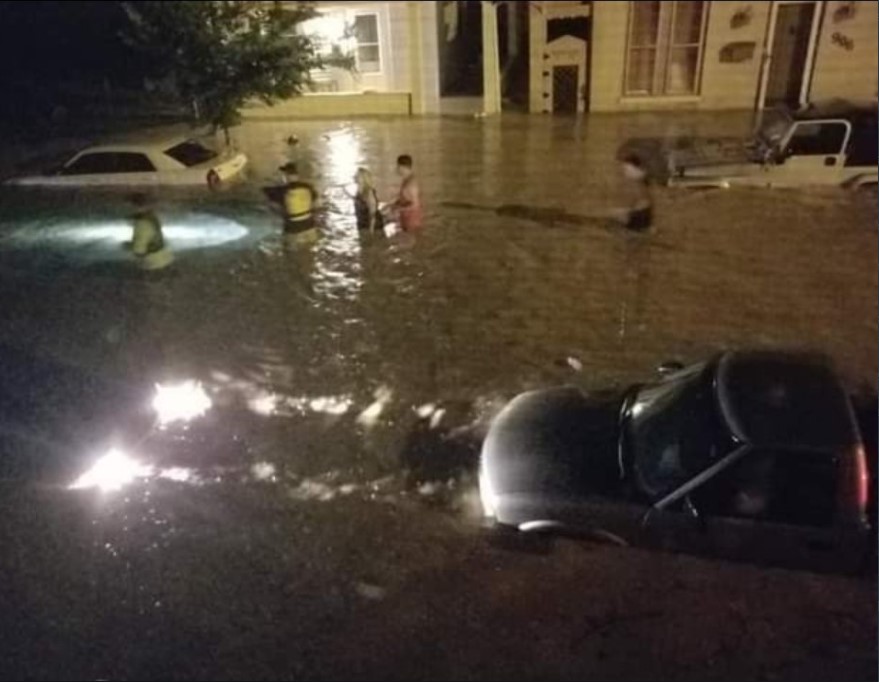
Walnut Street in Madison during the pre-dawn hours on the 19th. Photo courtesy Rob Connett
Current Hazards
Hazardous Weather Outlook
Storm Prediction Center
Submit a Storm Report
Advisory/Warning Criteria
Radar
Fort Knox
Evansville
Fort Campbell
Nashville
Jackson
Wilmington
Latest Forecasts
El Nino and La Nina
Climate Prediction
Central U.S. Weather Stories
1-Stop Winter Forecast
Aviation
IDSS Forecast Points
Air Quality
Fire Weather
Recreation Forecasts
1-Stop Drought
Event Ready
1-Stop Severe Forecast
Past Weather
Climate Graphs
1-Stop Climate
CoCoRaHS
Local Climate Pages
Tornado History
Past Derby/Oaks/Thunder Weather
Football Weather
Local Information
About the NWS
Forecast Discussion
Items of Interest
Spotter Training
Regional Weather Map
Decision Support Page
Text Products
Science and Technology
Outreach
LMK Warning Area
About Our Office
Station History
Hazardous Weather Outlook
Local Climate Page
Tornado Machine Plans
Weather Enterprise Resources
US Dept of Commerce
National Oceanic and Atmospheric Administration
National Weather Service
Louisville, KY
6201 Theiler Lane
Louisville, KY 40229-1476
502-969-8842
Comments? Questions? Please Contact Us.


 Weather Story
 Weather Map
 Local Radar