 |
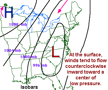
This picture shows an example of a high and low pressure system. At the surface, in the Northern Hemisphere, winds flow counterclockwise (cyclonically) around low pressure, and clockwise (anticyclonically) around high pressure. (Highs and lows spin the other way in the Southern Hemisphere.) The actual pressure of these systems can be measured in either inches of mercury (e.g., 30.10) or millibars (e.g., 1004 mb). Lines of equal pressure between highs and lows are called "isobars". Surface winds generally flow at an angle to the isobars from high to low pressure. |
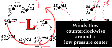 |
Here, a typical surface weather map shows winds rotating counterclockwise around a low pressure system. Each reporting station's observation gives wind direction and speed, temperature, dewpoint, and pressure at that station. |
 |
 |
|
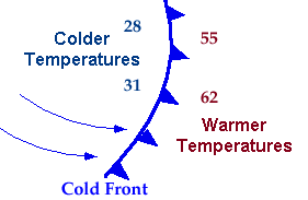
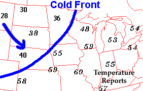
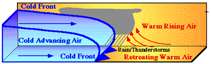
Surface low pressure systems usually have fronts associated with them. A front represents a boundary between two air masses that contain different temperature, wind, and moisture properties. Here, a cold front is shown which can be present any time of the year, but is most pronounced and noticeable during the winter. Air normally is warmer ahead of a cold front and colder behind it. With a cold front, cold air advances and displaces the warm air since cold air is more dense (heavier) than warm air. |
|
 |
|
|
This vertical cross-section of a cold front shows cold air behind the cold front (dark blue lines) advancing into warmer air ahead of the front. Where the two air masses meet, convergence often occurs which can result in upward motion of air parcels. If the air contains enough moisture, rain can occur. If the air also is unstable, thunderstorms can develop as well. This is a simplified view of a cold front. Sometimes, fronts aloft (above the surface) can result in precipitation ahead of cold fronts. |
|
 |
 |
|
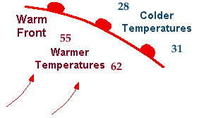
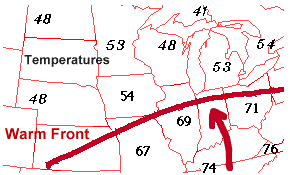
Warm fronts also are common, especially from Fall through Spring when larger temperature differences exist across the United States. Relatively cool or cold air is present ahead of a warm front with warmer air behind the front, i.e., the opposite from that of cold fronts. However, while cool air at the surface exists ahead of a warm front, relatively warmer air often is located above it as the warmer surface air behind the front rises up and over the cool air below. If enough moisture is present, this can result in precipitation along and ahead of the front. With a warm front, the cool air ahead of it must retreat before the warm air behind it can advance. |
|
 |
|
|
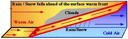
A vertical cross-section of a warm front (dark red lines) shows how surface warm air behind the warm front flows upward in a slantwise manner over top low-level cool or cold air ahead of the position of the surface warm front. This causes clouds and precipitation ahead of the surface warm front, assuming enough upward motion of air parcels and available moisture. |
|
 |
 |
|
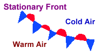
A stationary front is similar to a warm front, i.e., warm air is present behind it (to its south) with cool air ahead of it (to its north). However, while a warm front shows movement, a stationary front shows little or no movement as the cooler, more dense air remains in tact and does not retreat. Notice the winds from the northeast in the picture on the right above. Since these winds are blowing toward the front somewhat, this cooler air is not retreating, so the warmer air to the south of the front cannot lift northward. With a stationary front, a balance usually exists between the warmer and colder air masses on both sides of the front, so that neither air mass can advance on the other one. Thus, the front remains nearly stationary. |
|
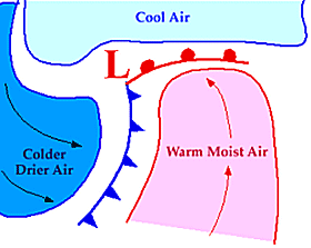 |
Here, we see what a typical low pressure system might look like on a surface weather map. A cold front extends to the south of the low pressure center, with a warm front to the east. Warm air is located ahead of the cold front and behind the warm front (the so-called "warm sector"), while cool air exists ahead of the warm front and cold air is present behind the cold front. Not all weather systems, however, are as simple as this model. |
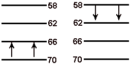 |
This graphic shows how temperature "advection" occurs. To "advect" means to move from one place to another via the wind. At far left, warm air is being advected to the north, i.e., from bottom (warmer) to top (cooler) by a south wind. This is called "warm air advection" and occurs, for example, with warm fronts. Warm air advection can occur at the surface or aloft, and given enough lift and moisture, will result in precipitation. At near left is the opposite. The wind is blowing from north to south moving cooler air toward the warmer air. This is called "cold air advection", and is what usually occurs behind cold fronts. |
 |
 |
|
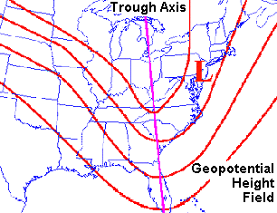
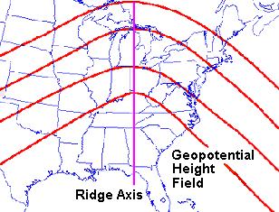
The weather on the surface of the earth is controlled significantly by what occurs in the atmosphere above. Therefore, meteorologists always analyze "upper air charts" for weather disturbances, moisture, temperatures, etc. and their expected changes to determine what weather likely will occur at the surface. The pictures above show what a very basic upper air weather map might look like (in this example, at 500 mb or about 18,000 feet). At left, we see a "trough" of low pressure, which may be associated with a low pressure system (red "L"), fronts, and precipitation at the surface ahead of the upper trough location. At right, we see a "ridge" of high pressure aloft. A surface high pressure system and often fair weather typically are located ahead (east) of an upper ridge axis with lower surface pressure behind (west of) the ridge. Troughs and ridges can be weak or quite strong. |
|
 |
 |
|
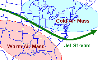
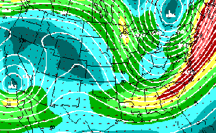
In looking at upper air data, we also closely examine the "jet stream" which is a relatively high speed ribbon of air between 25,000 and 40,000 feet above the ground. The jet stream is strongest in the winter when the greatest temperature differences exist across the Northern Hemisphere. In a general sense, warmest air masses are located south of the jet with cold air to its north (left picture). Changes in the jet stream pattern and different wind speeds within the jet play a major role in surface temperature and precipitation patterns. At right is a typical upper air chart (300 or 200 mb, i.e., about 30,000 or 40,000 feet) showing height (white) lines revealing troughs across southern California/Baja of Mexico and the eastern United States, with a ridge across much of the Rocky Mountains. In addition, wind vectors and colored isotachs (lines of equal wind speed) show the location of the jet stream (green colors). Yellow, red, and pink colored isotachs represent a ribbon of higher speed winds within the jet. Notice that within the jet stream, wind speeds usually differ. It is these differences in wind speeds within the jet stream that can cause significant weather. In this example, the highest winds are located along the East Coast. This is called a "jet streak" within the overall jet stream. |
|
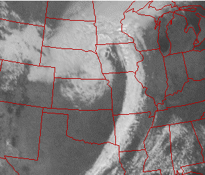 |
This picture is a satellite image showing clouds associated with a major low pressure system. Satellite pictures are taken by weather satellites located about 22,000 miles above the earth. The surface low center in this case likely would be located in western Iowa with a cold front extending south through Missouri into eastern Texas along the cloud band. Rain showers may be occurring within this band. Meanwhile, across Nebraska, South Dakata, Minnesota, and northern Wisconsin, steadier rain or snow may be occurring to the north and west of the surface low and warm front (which probably extends northeast from the low across central Wisconsin). |
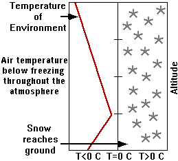 |
Now we will look at different precipitation types. The red line above represents a vertical profile of temperature in the atmosphere. Notice that temperatures (the red line) remain colder than 0 deg C (32 deg F) throughout the atmosphere. Thus, snow will form aloft and remain as snow as it falls to the ground. |
 |
 |
|
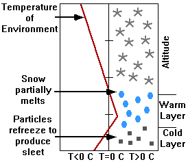
Now we see a different temperature profile. The air is colder than 0 deg C aloft where snow forms, but then warms to just above freezing in a small layer. In this layer, the falling snow partially melts so that the precipitation is now partly snow and partly water. As it continues to fall toward the surface where cold air again exists (temperature below freezing), the precipitation refreezes to form sleet or ice pellets. |
|
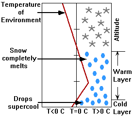 |
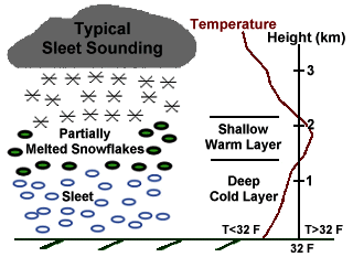
This temperature profile is fairly similar to that for sleet, although a warmer and deeper warm layer exists with a shallower cold layer near the surface. Therefore, snow falls from above where the temperature is cold enough, then it completely melts to rain within the warm layer. As the rain then falls into the shallow cold layer at the surface, it does not have time to refreeze until it hits the surface. Upon doing so, the "supercooled" raindrops freeze on exposed surfaces. This can be a very dangerous situation as ice is more difficult to walk and drive on than snow or sleet. |


 Weather Story
 Weather Map
 Local Radar