Overview
|
A major winter storm impacted the Ohio Valley on January 24-26, 2026. The storm dropped a swath of heavy snow and sleet ranging between 6 and 13 inches across southern Indiana and northern Kentucky. In addition, damaging amounts of ice from .20" to .80" were noted across much of central and eastern Kentucky.
Summary of Impacts to the Region: - Federal Disaster Declaration on January 23rd, 2026 ahead of the weather event. Kentucky State Emergency Operations Center activated to Level 2 on the morning of January 24th. - Power outages across southern, central, and eastern Kentucky peaked around 75,000 on Sunday afternoon, mostly from freezing rain/ice impacts. - Every county in the state of Kentucky was put under a Winter Storm Warning. - 65,000 personnel from 43 states and Canada were pre-positioned to assist with utility restoration ahead of the storm. - During the peak of the weather event, over 350 resource requests had been received by the Kentucky State Emergency Operations Center. - 109 counties across Kentucky declared a State of Emergency. - 136 Shelters were opened across the state of Kentucky. - 937 people used warming shelters at the peak of the event. - 1 confirmed fatality resulting from cold impacts following the winter weather. |
Snow/Ice
Below are observed total snow and ice accumulations from the January 24-26, 2026 Winter Storm.


Photos & Video
Franklin, KY
 |
 |
 |
 |
| Courtesy of @StateLineWX on X | Courtesy of @StateLineWX on X | Courtesy of @StateLineWX on X | Courtesy of @StateLineWX on X |
Louisville, KY (Middletown/Shelbyville Rd area)
 |
 |
 |
 |
| Courtesy of CJ Padgett | Courtesy of CJ Padgett | Courtesy of CJ Padgett | Courtesy of CJ Padgett |
Scottsville, KY
 |
 |
 |
 |
| Courtesy of Jamie Perretta | Courtesy of Jamie Perretta | Courtesy of Jamie Perretta | Courtesy of Jamie Perretta |
 |
 |
 |
 |
| Courtesy of Jamie Perretta | Courtesy of Jamie Perretta | Courtesy of Jamie Perretta | Courtesy of Jamie Perretta |
 |
 |
 |
|
| Courtesy of Kristen Keown | Courtesy of Kristen Keown | Courtesy of Kristen Keown |
 |
 |
 |
 |
| Courtesy of David Calvert | Courtesy of David Calvert | Courtesy of David Calvert | Courtesy of David Calvert |
Tompkinsville, KY
 |
 |
 |
 |
| Courtesy of Jake Z. | Courtesy of Jake Z. | Courtesy of Jake Z. | Courtesy of Jake Z. |
Other Area Photos
 |
 |
 |
 |
| Glasgow, KY Courtesy of Ashley Orehek |
Elizabethtown, KY Courtesy of Tom Williams |
Elizabethtown, KY Courtesy of Tom Williams |
Milton, KY Courtesy of Katelyn Brooks |
 |
|||
| Woodburn, KY Courtesy of Sara McDonald |
Storm Reports
 |
 |
...LSR SUMMARY FOR JANUARY 24-26, 2026 WINTER STORM EVENT...
..TIME... ...EVENT... ...CITY LOCATION... ...LAT.LON...
..DATE... ....MAG.... ..COUNTY LOCATION..ST.. ...SOURCE....
..REMARKS..
0200 PM Freezing Rain 1 ESE Bowling Green 36.96N 86.42W
01/25/2026 M0.36 Inch Warren KY ASOS
Flat Ice Accretion. REPORTED AT KBWG.
0923 AM Freezing Rain 1 SSW Franklin 36.71N 86.58W
01/26/2026 M0.30 Inch Simpson KY Trained Spotter
Radial ice measurement.
0515 PM Freezing Rain Centertown 37.42N 87.00W
01/25/2026 M0.10 Inch Ohio KY Public
1245 PM Freezing Rain Tompkinsville 36.70N 85.69W
01/25/2026 M0.60 Inch Monroe KY Trained Spotter
0301 PM Freezing Rain Richmond 37.74N 84.30W
01/25/2026 M0.25 Inch Madison KY Public
0952 AM Freezing Rain Greensburg 37.26N 85.50W
01/26/2026 M0.25 Inch Green KY Trained Spotter
0100 PM Freezing Rain 6 W Lexington 38.04N 84.61W
01/25/2026 M0.30 Inch Fayette KY ASOS
0914 AM Freezing Rain 1 ENE Liberty 37.32N 84.91W
01/26/2026 E0.50 Inch Casey KY Emergency Mngr
0330 PM Freezing Rain Glasgow 37.00N 85.92W
01/25/2026 M0.40 Inch Barren KY Law Enforcement
Radial ice measurement converted to flat
ice.
1245 PM Freezing Rain 3 SSW Scottsville 36.71N 86.22W
01/25/2026 M0.65 Inch Allen KY CO-OP Observer
0635 PM Freezing Rain 1 SSE Winchester 37.98N 84.18W
01/25/2026 M0.50 Inch Clark KY Amateur Radio
Converted from a radial ice measurement to a
flat ice estimate.
0600 PM Freezing Rain Glasgow 37.00N 85.92W
01/25/2026 M0.75 Inch Barren KY Cocorahs
Radial ice measurement converted to flat ice
equivalent.
0700 AM Snow 1 SSE Midway 38.14N 84.68W
01/26/2026 M3.5 Inch Woodford KY Cocorahs
Cocorahs station KY-WF-16 Midway 0.7 SSE.
0807 PM Snow 2 SSE Bowling Green 36.94N 86.43W
01/25/2026 M3.0 Inch Warren KY Broadcast Media
0700 AM Snow 1 ESE Bowling Green 36.97N 86.42W
01/26/2026 M3.5 Inch Warren KY Official NWS Obs
0800 AM Snow 1 WSW Bowling Green 36.97N 86.45W
01/26/2026 M3.1 Inch Warren KY Cocorahs
Cocorahs station KY-WR-34 Bowling Green 0.7
WSW.
0638 PM Snow 1 NNE Milton 38.72N 85.37W
01/25/2026 M7.5 Inch Trimble KY Public
0700 AM Snow 2 W Elk Creek 38.10N 85.40W
01/26/2026 M5.0 Inch Spencer KY NWS Employee
0700 AM Snow 1 N Shelbyville 38.24N 85.23W
01/26/2026 M5.2 Inch Shelby KY Cocorahs
Cocorahs station KY-SH-15 Shelbyville 1.3 N.
0700 AM Snow 2 N Georgetown 38.23N 84.55W
01/26/2026 M5.3 Inch Scott KY Cocorahs
Cocorahs station KY-SC-1 Georgetown 1.3 NNE.
0600 PM Snow 1 WSW Buckner 38.38N 85.44W
01/25/2026 M7.0 Inch Oldham KY Public
0700 AM Snow 2 SSW Buckner 38.36N 85.45W
01/26/2026 M6.0 Inch Oldham KY Cocorahs
Cocorahs station KY-OL-1 Park Lake 1.8 NE.
0700 AM Snow 2 NNE La Grange 38.43N 85.36W
01/26/2026 M8.6 Inch Oldham KY Cocorahs
Cocorahs station KY-OL-8 La Grange 2.2 NNE.
0800 AM Snow Beaver Dam 37.41N 86.89W
01/26/2026 M4.2 Inch Ohio KY Cocorahs
Cocorahs station KY-OH-10 Beaver Dam 0.6 NW.
0800 AM Snow 1 W Balltown 37.73N 85.52W
01/26/2026 M4.0 Inch Nelson KY Cocorahs
Cocorahs station KY-NL-4 New Haven 6.4 NE.
0511 PM Snow 1 ENE Muldraugh 37.94N 85.99W
01/25/2026 M5.5 Inch Meade KY Emergency Mngr
0511 PM Snow 1 NNW Rhodelia 38.01N 86.42W
01/25/2026 M5.8 Inch Meade KY Emergency Mngr
0600 AM Snow 6 N Bradfordsville 37.58N 85.15W
01/26/2026 M4.4 Inch Marion KY Cocorahs
Cocorahs station KY-MR-2 5 N Bradfordsville.
0545 PM Snow 1 NE Russellville 36.85N 86.89W
01/25/2026 M3.5 Inch Logan KY Public
1000 AM Snow 2 E Epleys Station 36.94N 86.89W
01/26/2026 M1.0 Inch Logan KY Cocorahs
Cocorahs station KY-LG-10 Russellville 6.6
N.
0724 AM Snow 1 NNE Wilmore 37.87N 84.66W
01/26/2026 M2.8 Inch Jessamine KY Cocorahs
Cocorahs station KY-JS-17 Wilmore 0.6 NNE.
0332 PM Snow 2 SE Shively 38.17N 85.80W
01/25/2026 M5.8 Inch Jefferson KY Public
0338 PM Snow 2 SE Shively 38.17N 85.80W
01/25/2026 M5.8 Inch Jefferson KY Public
0525 PM Snow 4 SW Valley Station 38.06N 85.89W
01/25/2026 M5.0 Inch Jefferson KY Public
0558 PM Snow Fern Creek 38.15N 85.59W
01/25/2026 M5.5 Inch Jefferson KY Public
0626 PM Snow Prospect 38.35N 85.62W
01/25/2026 M7.5 Inch Jefferson KY Public
0700 AM Snow 1 SW Pewee Valley 38.30N 85.51W
01/26/2026 M5.7 Inch Jefferson KY Cocorahs
Cocorahs station KY-JF-1 Anchorage 2.8 NE.
0700 AM Snow 4 SE Pewee Valley 38.27N 85.44W
01/26/2026 M5.2 Inch Jefferson KY Cocorahs
Cocorahs station KY-JF-32 Middletown 4.9
ENE.
0700 AM Snow 1 W Saint Matthews 38.25N 85.66W
01/26/2026 M5.7 Inch Jefferson KY Cocorahs
Cocorahs station KY-JF-72 Bellewood 1.0 SSW.
0700 AM Snow 2 W Middletown 38.24N 85.56W
01/26/2026 M5.5 Inch Jefferson KY Cocorahs
Cocorahs station KY-JF-103 Douglass Hills
0.6 WNW.
0700 AM Snow 3 NW Anchorage 38.30N 85.57W
01/26/2026 M4.0 Inch Jefferson KY Cocorahs
Cocorahs station KY-JF-40 Louisville 11.0
ENE (Springhurst).
0800 AM Snow 2 W Middletown 38.24N 85.55W
01/26/2026 M4.5 Inch Jefferson KY Cocorahs
Cocorahs station KY-JF-99 Douglass Hills 0.2
N.
1000 AM Snow 4 ENE Middletown 38.25N 85.45W
01/26/2026 M5.6 Inch Jefferson KY NWS Employee
0439 PM Snow Smithfield 38.39N 85.26W
01/25/2026 M5.5 Inch Henry KY Amateur Radio
1100 AM Snow 1 WNW Eminence 38.37N 85.19W
01/26/2026 M5.0 Inch Henry KY Cocorahs
0600 AM Snow 1 NE Connersville 38.39N 84.41W
01/26/2026 M4.6 Inch Harrison KY Cocorahs
Cocorahs station KY-HR-6 Cynthiana 6.2 W.
0700 AM Snow 3 NNW Breckinridge 38.47N 84.38W
01/26/2026 M4.7 Inch Harrison KY Cocorahs
Cocorahs station KY-HR-10 Berry 3.6 S.
0700 AM Snow Oddville 38.45N 84.24W
01/26/2026 M4.6 Inch Harrison KY Cocorahs
Cocorahs station KY-HR-8 Cynthiana 5.6 NNE.
0352 PM Snow 2 E Elizabethtown 37.69N 85.84W
01/25/2026 M5.0 Inch Hardin KY Public
Corrects previous snow report from 2 E
Elizabethtown.
0730 AM Snow 3 SE Colesburg 37.75N 85.74W
01/26/2026 M5.5 Inch Hardin KY Cocorahs
Cocorahs station KY-HD-20 Elizabethtown 7.9
ENE.
0800 AM Snow 2 W Vine Grove 37.81N 86.01W
01/26/2026 M5.1 Inch Hardin KY Cocorahs
Cocorahs station KY-HD-33 Vine Grove 1.7 W.
0830 AM Snow 2 SE Elizabethtown 37.69N 85.84W
01/26/2026 M4.0 Inch Hardin KY Cocorahs
Cocorahs station KY-HD-5 Elizabethtown 1.8
SE.
0952 AM Snow Greensburg 37.26N 85.50W
01/26/2026 M2.7 Inch Green KY Trained Spotter
0800 AM Snow 1 SE Ready 37.35N 86.45W
01/26/2026 M2.6 Inch Grayson KY Cocorahs
Cocorahs station KY-GY-9 1 SE Ready.
0700 AM Snow 2 W Forks of Elkhorn 38.22N 84.83W
01/26/2026 M6.5 Inch Franklin KY CO-OP Observer
CO-OP Observer station RVEK2 Ridgeview
Estates 3 NE.
0800 AM Snow 4 N Alton 38.14N 84.93W
01/26/2026 M5.0 Inch Franklin KY Cocorahs
Cocorahs station KY-FR-23 Frankfort 5.0 SW.
0500 AM Snow 2 SSE Lexington 38.02N 84.50W
01/26/2026 M3.5 Inch Fayette KY Cocorahs
Cocorahs station KY-FY-9 Lexington 1.7 SSE.
0700 AM Snow 6 W Lexington 38.04N 84.61W
01/26/2026 M5.5 Inch Fayette KY Official NWS Obs
Storm Total for January 24 through the
morning of January 26.
0700 AM Snow 1 SE Liberty 37.31N 84.92W
01/26/2026 M3.3 Inch Casey KY Cocorahs
Cocorahs station KY-CS-4 Liberty 1.1 SE.
0914 AM Snow 1 ENE Liberty 37.32N 84.91W
01/26/2026 E4.5 Inch Casey KY Emergency Mngr
Snow and sleet combined.
0800 AM Snow 1 S Aberdeen 37.23N 86.68W
01/26/2026 M4.0 Inch Butler KY CO-OP Observer
CO-OP Observer station ABEK2 Aberdeen.
0700 AM Snow 2 WSW Mount Washington 38.04N 85.59W
01/26/2026 M7.7 Inch Bullitt KY Cocorahs
Cocorahs station KY-BT-25 Mount Washington
2.1 WSW.
0700 AM Snow 3 W Big Spring 37.79N 86.23W
01/26/2026 M5.9 Inch Breckinridge KY CO-OP Observer
CO-OP Observer station CNRK2 Corners.
1000 AM Snow 2 NE Glasgow 37.02N 85.89W
01/26/2026 M2.5 Inch Barren KY Cocorahs
0800 AM Snow Lawrenceburg 38.04N 84.90W
01/26/2026 M4.5 Inch Anderson KY Cocorahs
Cocorahs station KY-AN-12 Lawrenceburg 0.4
NNW.
0800 AM Snow 3 WSW Lawrenceburg 38.01N 84.94W
01/26/2026 M3.5 Inch Anderson KY Cocorahs
Cocorahs station KY-AN-16 Lawrenceburg 2.8
WSW.
0700 AM Snow 2 SW Scottsville 36.73N 86.22W
01/26/2026 M5.4 Inch Allen KY CO-OP Observer
CO-OP Observer station SCTK2 Scottsville 3
SSW.
0800 AM Snow 2 WNW Scottsville 36.76N 86.24W
01/26/2026 M3.0 Inch Allen KY Cocorahs
Cocorahs station KY-AL-20 Scottsville 2.3
WNW.
0715 AM Snow 1 ENE Mckinley 38.76N 86.18W
01/26/2026 M12.5 Inch Washington IN Cocorahs
Cocorahs station IN-WS-27 Campbellsburg 8.4
NNE.
0900 PM Snow 1 NW Scottsburg 38.70N 85.79W
01/25/2026 M10.5 Inch Scott IN Public
0800 AM Snow 2 ESE Leopold 38.09N 86.56W
01/26/2026 M6.5 Inch Perry IN Cocorahs
Cocorahs station IN-PY-6 Leopold 1.7 ESE.
0700 PM Snow 3 NW Syria 38.61N 86.44W
01/25/2026 M13.0 Inch Orange IN Public
0700 AM Snow French Lick 38.55N 86.62W
01/26/2026 M12.0 Inch Orange IN Public
0700 AM Snow 1 S Hanover 38.70N 85.47W
01/26/2026 M10.0 Inch Jefferson IN Cocorahs
Cocorahs station IN-JF-1 Hanover 1.4 S.
0700 AM Snow 2 NE New Middletown 38.18N 86.02W
01/26/2026 M6.0 Inch Harrison IN Trained Spotter
0700 AM Snow 2 NNW White Cloud 38.26N 86.25W
01/26/2026 M7.0 Inch Harrison IN Cocorahs
Cocorahs station IN-HR-5 Milltown 5.7 SSE.
0600 AM Snow 2 WNW Floyds Knobs 38.32N 85.90W
01/26/2026 M6.3 Inch Floyd IN Cocorahs
Cocorahs station IN-FD-22 Galena 3.0 SE.
0800 AM Snow 3 ESE Scottsville 38.38N 85.87W
01/26/2026 M9.2 Inch Floyd IN Cocorahs
Cocorahs station IN-FD-2 Galena 4.3 ENE.
0700 AM Snow Portersville 38.50N 86.98W
01/26/2026 M13.0 Inch Dubois IN Trained Spotter
0700 AM Snow Holland 38.25N 87.04W
01/26/2026 M8.0 Inch Dubois IN Cocorahs
Cocorahs station IN-DB-17 Holland 0.2 W.
0801 AM Snow Huntingburg 38.29N 86.96W
01/26/2026 M11.8 Inch Dubois IN Cocorahs
0815 AM Snow Celestine 38.38N 86.78W
01/26/2026 M10.5 Inch Dubois IN Cocorahs
Cocorahs station IN-DB-11 Celestine 0.3 WSW.
0815 AM Snow 1 WSW Mentor 38.31N 86.73W
01/26/2026 E10.0 Inch Dubois IN Cocorahs
Event total.
0700 AM Snow 1 NW Jeffersonville 38.31N 85.74W
01/26/2026 M6.0 Inch Clark IN Cocorahs
Cocorahs station IN-CK-18 Jeffersonville 0.8
NW.
0606 PM Snow Buckner 38.38N 85.43W
01/25/2026 M6.9 Inch Oldham KY Public
Event total snow and sleet accumulation.
0650 PM Snow 2 WNW Pewee Valley 38.32N 85.52W
01/25/2026 M8.5 Inch Oldham KY Trained Spotter
Storm total snow accumulation.
0515 PM Snow Centertown 37.42N 87.00W
01/25/2026 E5.5 Inch Ohio KY Public
Storm total snow and sleet accumulation.
0511 PM Snow 1 ENE Brandenburg 38.00N 86.17W
01/25/2026 E6.0 Inch Meade KY Emergency Mngr
Combined snow and sleet totals.
0551 PM Snow 3 WNW Pewee Valley 38.32N 85.54W
01/25/2026 E8.1 Inch Jefferson KY Public
Event total snow and sleet accumulation.
0700 PM Snow 1 N Louisville Intl Ai 38.17N 85.74W
01/25/2026 M5.9 Inch Jefferson KY Official NWS Obs
Storm total snow and sleet accumulation at
Louisville International Airport (KSDF).
0700 PM Snow 2 SSW Highview 38.11N 85.65W
01/25/2026 M5.6 Inch Jefferson KY Official NWS Obs
Storm total snow and sleet measurement at
the NWS Louisville office.
0707 PM Snow 4 ENE Middletown 38.26N 85.45W
01/25/2026 M5.2 Inch Jefferson KY Trained Spotter
Combined storm total snow and sleet.
0725 PM Snow 2 SSW Vine Grove 37.79N 85.98W
01/25/2026 M5.5 Inch Hardin KY NWS Employee
Storm total snow and sleet accumulation.
0635 PM Snow 1 SSE Winchester 37.98N 84.18W
01/25/2026 M3.3 Inch Clark KY Amateur Radio
Event total snow and sleet accumulation.
0552 PM Snow Hanover 38.72N 85.48W
01/25/2026 M10.0 Inch Jefferson IN Cocorahs
Storm total snowfall.
0600 PM Snow 2 S Saint Joseph 38.36N 85.81W
01/25/2026 M7.0 Inch Floyd IN Trained Spotter
Event total snow and sleet accumulation.
0625 PM Snow Saint Anthony 38.32N 86.83W
01/25/2026 M8.5 Inch Dubois IN Trained Spotter
Event total snow and sleet accumulation.
0535 PM Snow Borden 38.47N 85.95W
01/25/2026 M7.5 Inch Clark IN Broadcast Media
Event total accumulation.
0552 PM Snow 2 ENE Speed 38.43N 85.71W
01/25/2026 E8.0 Inch Clark IN Public
Event total snow and sleet accumulation.
0630 PM Snow 1 SSW Hamburg 38.37N 85.77W
01/25/2026 M6.4 Inch Clark IN NWS Employee
Event total snow and sleet accumulation.
0445 PM Snow/Ice Dmg 1 WSW Bowling Green 36.97N 86.46W
01/25/2026 Warren KY Public
Delayed report from social media. Photo
shows power pole snapped due to tree
branches falling on power lines just south
of downtown Bowling Green.
0826 AM Snow/Ice Dmg 1 SSW Plano 36.88N 86.42W
01/26/2026 Warren KY Trained Spotter
Corrects previous snow/ice dmg report from 1
SSW Plano. Actual location is 1 SSW
Franklin. Disregard this LSR.
0826 AM Snow/Ice Dmg 1 SSW Franklin 36.71N 86.58W
01/26/2026 Simpson KY Trained Spotter
Photos on social media show tree damage due
to ice accretion.
Environment
A strong low pressure system moved through the Ohio Valley January 24-26, 2026. The following images (Figures 1-3) show it's strength at the surface, mid levels and upper levels of the atmosphere.
 |
 |
 |
| Figure 1: Jan 25 7am Sfc Analysis | Figure 2: Jan 25 7am 500 mb Analysis | Figure 3: Jan 25 7am 300 mb Analysis |
This Winter Storm featured strong frontogenetical forcing as shown in Figures 4 & 5 which led to higher than normal snow, sleet and freezing rain accumulations. Figure 6 depicts the strong warm layer aloft that help create the sleet and freezing rain precipitation types.
.gif) |
.gif) |
 |
| Figure 4: Jan 25 7am 850 mb Frontogenesis | Figure 5: Jan 25 7am 700 mb Frontogenesis | Figure 6: Jan 24 10pm 850 mb Temperature Advection |
The last two figures below show higher than normal precipitable water values (Figure 7) and a healthy axis of instability aloft (MUCAPE - Figure 8) which contributed to efficient precipitation production and strong intensity at times.
.gif) |
.gif) |
|
| Figure 7: Jan 25 7am Precipitable Water | Figure 8: Jan 25 7am MUCAPE |
Additional Information
The Forecast
 |
 |
 |
| Potential for a Winter Storm followed by Extreme Cold highlighted on Jan 19th (5 days ahead of storm) |
Winter Storm Watch Issued issued Jan 21st (3 days ahead of storm) |
Winter Storm Warning issued Jan 22nd (2 days ahead of storm) |
 |
 |
 |
| Initial Snow/Ice Accums forecasted on Jan 23rd | Dangerously Cold Air forecasted behind the Winter Storm (Jan 23rd) | Forecasted Snow/Ice Accums refined just ahead of the Winter Storm (Jan 24th) |
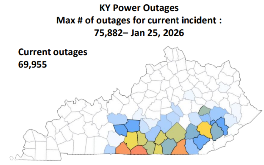
Power outages peaked around 75,000 on Sunday afternoon
Briefings
 |
 |
| WCM Mike Kochasic briefing Gov Andy Beshear on the Winter Storm | Forecaster Brian Neudorff giving a weather briefing at the Louisville Mayor's Winter Storm Press Conference |
NWS Weather briefings at the Louisville Mayor's Winter Storm Press Conferences
 |
Media use of NWS Web News Stories is encouraged! Please acknowledge the NWS as the source of any news information accessed from this site. |
|


 Weather Story
 Weather Map
 Local Radar