Louisville, KY
Weather Forecast Office

Public Information Statement
National Weather Service Louisville, KY
1139 AM EDT Wed Sep 25 2024 /1039 AM CDT Wed Sep 25 2024/

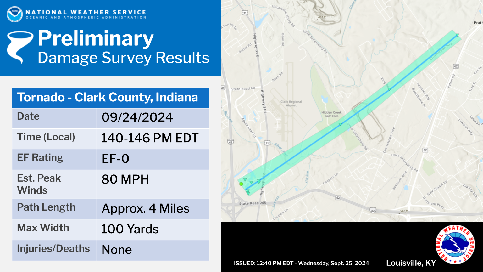
...NWS Damage Survey for 09/24/2024 Tornado Event...

.Clark County, Indiana...

Rating:                 EF-0
Estimated Peak Wind:    80 mph
Path Length /statute/:  4 miles
Path Width /maximum/:   100 yards
Fatalities:             0
Injuries:               0

Start Date:             09/24/2024
Start Time:             01:40 PM EDT
Start Location:         Cementville / Clark County / IN
Start Lat/Lon:          38.3493 / -85.7513

End Date:               09/24/2024
End Time:               01:46 PM EDT
End Location:           2 N Watson / Clark County / IN
End Lat/Lon:            38.3819 / -85.6929

Survey Summary:

The National Weather Service damage survey team confirmed an EF-0
between Clarksville and Sellersburg Indiana. The tornado touched
down just northeast of the interstate 65 and interstate 265
interchange. The majority of the damage was in the Silver Lake
Trailer Park. Sporadic tree damage, power poles, and cross members
were the main damage. Trees were uprooted and topped, hitting 2
different mobile homes and were facing from the north to the
northeast. There were 9 power poles and 7 cross members heavily
damaged. Some mobile homes had foundation movements. Tornado wind
speeds were estimated to be 80 mph, with a width up to 100 yards
wide.

A railroad arm at Apple Leaf Lane and US31 was bent significantly.
The tornado damaged a couple of trees in fields as it moved to the
northeast towards Charlestown Pike. Near the Prather One Room
School and Ladies Union Club on Charlestown Pike, there were
several trees twisted and topped. Tornado wind speeds were
estimated to be 75 mph, with a width up to 50 yards wide. The
tornado lifted just northeast of Charlestown Pike.

The National Weather Service would like to thank Clark County
Emergency Management Director Gavan Hebner and his team for their
assistance with the survey.


&&

EF Scale: The Enhanced Fujita Scale classifies tornadoes into the
following categories:

EF0.....65 to 85 mph
EF1.....86 to 110 mph
EF2.....111 to 135 mph
EF3.....136 to 165 mph
EF4.....166 to 200 mph
EF5.....>200 mph

NOTE:
The information in this statement is preliminary and subject to
change pending final review of the event and publication in NWS
Storm Data.

$$
Gordon/Nunn/LaDuke/Ledbetter
Have Storm Damage? Know of Some? We want your report.... You can fill out this form it's VERY IMPORTANT we have DATE, Best Guess Time it Occurred and your Location...
Current Hazards
Hazardous Weather Outlook
Storm Prediction Center
Submit a Storm Report
Advisory/Warning Criteria
Radar
Fort Knox
Evansville
Fort Campbell
Nashville
Jackson
Wilmington
Latest Forecasts
El Nino and La Nina
Climate Prediction
Central U.S. Weather Stories
1-Stop Winter Forecast
Aviation
Spot Request
Air Quality
Fire Weather
Recreation Forecasts
1-Stop Drought
Event Ready
1-Stop Severe Forecast
Past Weather
Climate Graphs
1-Stop Climate
CoCoRaHS
Local Climate Pages
Tornado History
Past Derby/Oaks/Thunder Weather
Football Weather
Local Information
About the NWS
Forecast Discussion
Items of Interest
Spotter Training
Regional Weather Map
Decision Support Page
Text Products
Science and Technology
Outreach
LMK Warning Area
About Our Office
Station History
Hazardous Weather Outlook
Local Climate Page
Tornado Machine Plans
Weather Enterprise Resources
US Dept of Commerce
National Oceanic and Atmospheric Administration
National Weather Service
Louisville, KY
6201 Theiler Lane
Louisville, KY 40229-1476
502-969-8842
Comments? Questions? Please Contact Us.


 Weather Story
 Weather Map
 Local Radar