
Showers and thunderstorms, along with high-elevation snow, will begin to develop over parts of the Southwest late tonight and is expected to continue through Wednesday morning. Mountain snow over parts the Northeast will continue through Tuesday. A few strong to severe storms and heavy rainfall are possible across portions of the Lower Ohio Valley Tuesday. Read More >
Louisville, KY
Weather Forecast Office
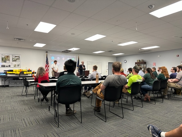
NWS Louisville attended the Ohio River Basin Tri-agency Meeting this past week which is a hydrology focused meeting between the NWS, USGS and USACE. These agencies work together to improve and manage river and reservoir observations and forecasts across the Ohio Valley. Also, NWS Louisville was invited to speak to National USGS Director Dr. Applegate during his visit to the USGS in Louisville this past week. NWS Louisville Service Hydrologist Andrea Schoettmer spoke to the Director about the great collaboration between the USGS and NWS and how the USGS robust river gauge network provides ground truth and aides NWS river forecasts. Another hot topic of conversation was the Eastern KY Flood of July 2022, and how our agencies can work together to improve river observations and flood warning systems for rural communities like those of Eastern KY.
The image below shows Dr. Applegate addressing the USGS Louisville staff.
 |
Current Hazards
Hazardous Weather Outlook
Storm Prediction Center
Submit a Storm Report
Advisory/Warning Criteria
Radar
Fort Knox
Evansville
Fort Campbell
Nashville
Jackson
Wilmington
Latest Forecasts
El Nino and La Nina
Climate Prediction
Central U.S. Weather Stories
1-Stop Winter Forecast
Aviation
Spot Request
Air Quality
Fire Weather
Recreation Forecasts
1-Stop Drought
Event Ready
1-Stop Severe Forecast
Past Weather
Climate Graphs
1-Stop Climate
CoCoRaHS
Local Climate Pages
Tornado History
Past Derby/Oaks/Thunder Weather
Football Weather
Local Information
About the NWS
Forecast Discussion
Items of Interest
Spotter Training
Regional Weather Map
Decision Support Page
Text Products
Science and Technology
Outreach
LMK Warning Area
About Our Office
Station History
Hazardous Weather Outlook
Local Climate Page
Tornado Machine Plans
Weather Enterprise Resources
US Dept of Commerce
National Oceanic and Atmospheric Administration
National Weather Service
Louisville, KY
6201 Theiler Lane
Louisville, KY 40229-1476
502-969-8842
Comments? Questions? Please Contact Us.


 Weather Story
 Weather Map
 Local Radar