Isolated heavy rainfall will continue through tonight across portions of central Texas, though some relief from the heavy rain is expected on Tuesday. Heat and humidity will remain in place across the Eastern U.S. and interior Northwest U.S. over the next few days with widespread moderate to major Heat Risk. Dangerous heat will build into the Desert Southwest Tuesday through Thursday. Read More >
Overview
|
A couple of lines of storms merged across southwest Indiana and west central Kentucky before moving into our region and causing widespread wind damage as well as a couple of tornadoes across south central Kentucky. |
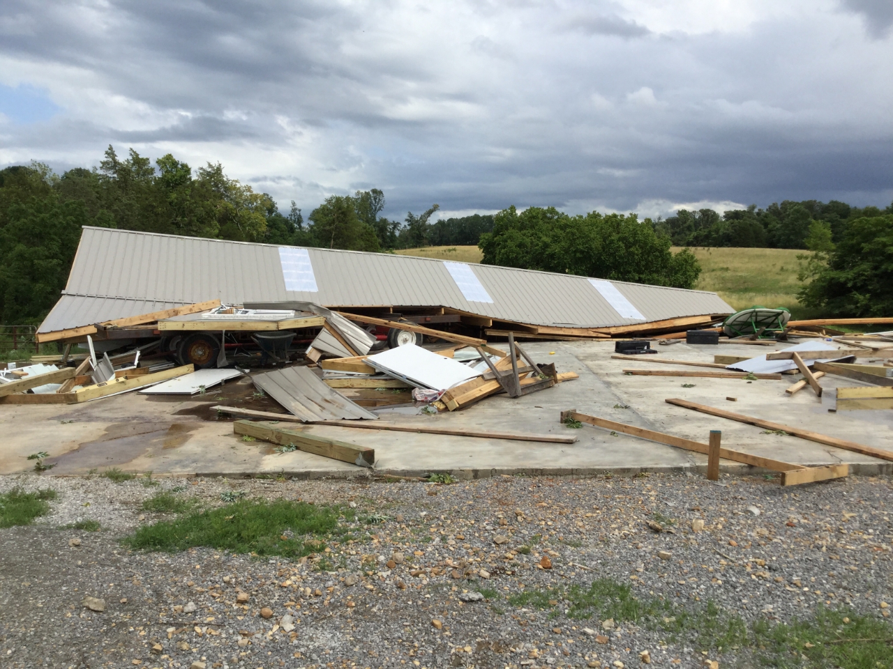
 Barn downed by EF-1 Tornado west of Scottsville, KY |
Tornadoes:
|
|
||||||||||
|
||||||||||

Tornado - Hillsdale, KY
Track Map 
|
||||||||||||||||

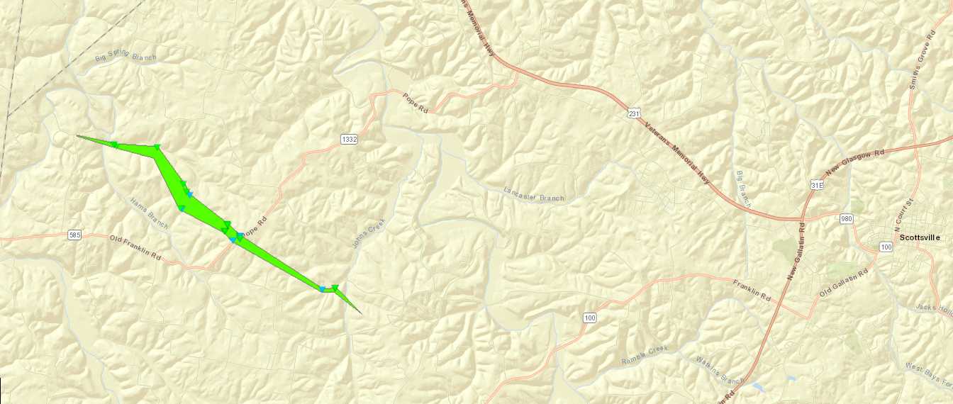
Tornado - Mount Aerial, KY
Track Map 
|
||||||||||||||||
Tornado - Amos, KY
Allen County
| Date | 06/21/2019 |
| Time (Local) | 904 PM EDT |
| EF Rating | EF-1 |
| Est. Peak Winds | 90 MPH |
| Path Length | 1.6 Miles |
| Max Width | 125 Yards |
| Injuries/Deaths | 0 |
Summary:
THE NATIONAL WEATHER SERVICE CONDUCTED A STORM DAMAGE SURVEY ACROSS SOUTHEAST ALLEN COUNTY TO ASSESS DAMAGE FROM THE STORMS ON FRIDAY EVENING, JUNE 21. THERE WAS A SIGNIFICANT AMOUNT OF STRAIGHT LINE WIND DAMAGE ACROSS SOUTHERN ALLEN COUNTY. MOST OF THIS DAMAGE HAD WIND SPEEDS BETWEEN 60-65 MPH ALL FACING EAST SOUTHEAST DIRECTION. THERE WERE TWO SIGNIFICANT AREAS OF STRAIGHT LINE WIND DAMAGE. THERE WAS A BARN NORTH OF AMOS ON HIGHWAY 99. THE SECOND WAS TWO LARGE BARNS JUST NORTH OF HAYESVILLE, TN. INTERSPERSED AMONGST THE STRAIGHT LINE WIND DAMAGE WAS A TORNADO WHICH FIRST TOUCHED DOWN A HALF MILE EAST OF AMOS. A FAMILY FARM HAD NUMEROUS TREES TWISTED, SNAPPED, AND UPROOTED. SEVERAL BARNS SUSTAINED SEVERE STRUCTURAL DAMAGE TO THE ROOFS. A DOZEN OR SO PORTIONS OF TWO BY FOURS WERE IMPALED INTO THE GROUND IN MULTIPLE DIRECTIONS. FURTHER SOUTHEAST ON HIGHLAND CHURCH ROAD NUMEROUS TREES WERE UPROOTED AND SNAPPED WITH TREES FACING FROM THE NORTH NORTHEAST TO THE SOUTHEAST DIRECTION. THERE WAS CLEAR EVIDENCE THAT THE TORNADO WENT TO THE TENNESSEE STATE LINE IN MACON COUNTY AS WE COULD SEE TREES SNAPPED AND UPROOTED ON THE STATE LINE WHICH CORRELATES WELL THE NWS NASHVILLE STORM SURVEY ACROSS MACON COUNTY. AT 2592 HIGHLAND CHURCH ROAD (HIGHLAND GENERAL BAPTIST CHURCH) THERE WAS SIGNIFICANT BRICK DAMAGE ON THE WEST, SOUTH AND EAST SIDES OF THE CHURCH DUE TO OPEN VENTS. THE SURVEY CREW ZIG ZAGGED ACROSS ROADS SOUTH OF SCOTTSVILLE TO HIGHWAY 31 BUT ONLY FOUND SPORADIC STRAIGHT LINE TREE AND BARN DAMAGE ALL FACING SOUTHEASTERLY DIRECTION. THE VERY LAST CONCENTRATED AREA OF DAMAGE THE TEAM FOUND WAS AT 444 OLD BUCK CREEK ROAD WERE THERE WAS NUMEROUS SOFTWOOD TREE DAMAGE AT THE RESIDENCE WITH POWER POLES DOWN ACROSS THE ROAD. THE NATIONAL WEATHER SERVICE WOULD LIKE TO THANK WBKO METEOROLOGIST SHANE HOLINDE, WKU METEOROLOGY STUDENT MATTHEW WINE, NWS STUDENT VOLUNTEERS EVAN HATTER AND OLIVIA CAHILL, AND FUTURE METEOROLOGIST COOPER BENNETT WITH THEIR ASSISTANCE WITH THE STORM SURVEY. |
 |
The enhanced Fujita (EF) Scale classifies tornadoes into the following categories:
| EF0 Weak 65-85 mph |
EF1 Moderate 86-110 mph |
EF2 Significant 111-135 mph |
EF3 Severe 136-165 mph |
EF4 Extreme 166-200 mph |
EF5 Catastrophic 200+ mph |
 |
|||||
Storm Reports
..TIME... ...EVENT... ...CITY LOCATION... ...LAT.LON...
..DATE... ....MAG.... ..COUNTY LOCATION..ST.. ...SOURCE....
..REMARKS..
0556 PM Tstm Wnd Dmg 1 SW Huntingburg 38.28N 86.97W
06/21/2019 Dubois IN Emergency Mngr
EM reports tree down across Old SR 64 near
Huntingburg. Also had report of tree down
across Division Road west of Jasper. Time
estimated based on radar.
0617 PM Tstm Wnd Dmg 1 SSW Ferdinand 38.21N 86.87W
06/21/2019 Dubois IN Emergency Mngr
Report of one large tree down adjacent to
house near E Mariah Hill Road near
Ferdinand.
0649 PM Tstm Wnd Dmg 2 NNW Beda 37.53N 86.97W
06/21/2019 Ohio KY 911 Call Center
Report of tree down near US HWY 231 N.
0654 PM Tstm Wnd Dmg 3 SE Patesville 37.76N 86.68W
06/21/2019 Hancock KY 911 Call Center
Tree down across State Route 1700. Time
estimated from radar.
0720 PM Tstm Wnd Dmg Garfield 37.79N 86.35W
06/21/2019 Breckinridge KY 911 Call Center
Report of tree fallen on power lines near W
HWY 86. Power lines on the ground, and local
power outages.
0725 PM Tstm Wnd Dmg Vertrees 37.70N 86.14W
06/21/2019 Hardin KY Amateur Radio
Large tree completely blocking road and on
power lines. Near 12000 block of Hardinsburg
Road in Hardin Co.
0732 PM Hail 2 SE Cool Springs 37.28N 86.85W
06/21/2019 E1.00 inch Ohio KY Public
Social Media report of quarter size hail in
southern Ohio County.
0808 PM Tstm Wnd Dmg 1 SW Russellville 36.83N 86.91W
06/21/2019 Logan KY 911 Call Center
Corrects previous tstm wnd dmg report from 1
SW Russellville. Trees and power lines down.
Possible fire due to lightning strike.
REPORTED NEAR 100 BLOCK OF NORTH CRESCENT
LANE, RUSSELLVILLE KY.
0827 PM Heavy Rain 2 WSW Woodbury 37.16N 86.67W
06/21/2019 M1.17 inch Butler KY Mesonet
KY Mesonet reports 1.17 inches at Butler
County site in last 15 minutes.
0828 PM Tstm Wnd Dmg 2 S Woodburn 36.81N 86.53W
06/21/2019 Simpson KY 911 Call Center
Corrects previous tstm wnd dmg report from 2
S Woodburn. Tree down. Blocking entire road.
REPORTED IN 3000 BLOCK OF SPORTSMAN LAKE
ROAD WOODBURN, KY.
0830 PM Tstm Wnd Dmg 3 E Franklin 36.73N 86.53W
06/21/2019 Simpson KY 911 Call Center
Corrects previous tstm wnd dmg report from 3
E Franklin. Tree down on road. REPORTED IN
100 BLOCK OF ROARK ROAD FRANKLIN.
0830 PM Tstm Wnd Dmg 5 WNW Mammoth Cave 37.24N 86.18W
06/21/2019 Edmonson KY 911 Call Center
Report of tree down across Ollie Ridge Road.
Time estimated from radar.
0830 PM Tstm Wnd Dmg 1 WSW Boyce 36.83N 86.38W
06/21/2019 Warren KY Public
Corrects previous tstm wnd dmg report from 1
WSW Boyce. Unknown cause. Report from public
who heard about the incident on police
scanner to EMS. REPORTED IN 10000 BLOCK OF
WOODBURN ALLEN SPRINGS RD, ALVATON, KY
42122.
0832 PM Tstm Wnd Dmg 3 SW Plano 36.85N 86.45W
06/21/2019 Warren KY Public
Tree down. Social media report. REPORTED AT
OLD UNION CHURCH ROAD KENTUCKY 42104.
0835 PM Tornado 4 NNW Gold City 36.80N 86.48W
06/21/2019 Simpson KY NWS Storm Survey
Brief EF1 tornado touched down near I-65.
The survey crew found a mixture of straight
line winds and a small area of a tornado
embedded within. The tornado hit the Salem
Road area hard with extensive tree damage. A
wheat field had distinct circulations quite
visible. The tornado was on the ground for
0.6 miles with a width of 75 yards.
0835 PM Tstm Wnd Gst 3 ENE Providence 36.68N 86.61W
06/21/2019 M51 MPH Simpson KY Mesonet
Measured at the Simpson County Kentucky
Mesonet station.
0838 PM Tstm Wnd Dmg Gold City 36.75N 86.45W
06/21/2019 Simpson KY Broadcast Media
Viewer reports numerous trees down along
Craft Road and Barn School Road.
0838 PM Tstm Wnd Dmg 4 NNW Gold City 36.80N 86.48W
06/21/2019 Simpson KY Broadcast Media
Social media report of roof blown off a home
on Blackjack Rd in NE Simpson County.
Located near Whiteside Ford Rd. Time
estimated from radar.
0839 PM Tornado 1 NNW Mt. Arieal 36.77N 86.39W
06/21/2019 Allen KY NWS Storm Survey
Another EF1 tornado embedded within a
widespread swath of straight line wind
damage. This one was on the ground longer,
4.6 miles and had a peak wind of 95 mph and
width of 125 yards. The tornado touched down
near Horseshoe Ford Road where numerous
large hardwood trees split, twisted, and
uprooted facing from due northerly to
southeasterly. Along Mayhew Road a large,
well-build barn was uplifted and removed
from its foundation. Downstream a large corn
field had corn flattened and twisted in
multiple directions. A couple of large heavy
fuel tanks were rolled into two different
directions, also on Mayhew Road. Several
barns and outbuildings had roof damage.
There were indications there may have been
more than one tornado. The width of the
individual circulations varied between 75
and 125 yards. The tornado dissipated near
Hwy 585 and the intersection of Shirk Rd.
and Grider Dr. The survey crew traveled all
along southern Allen County south of
Scottsville and found straight line winds
facing east and southeasterly directions.
0843 PM Tstm Wnd Dmg 3 E Franklin 36.72N 86.52W
06/21/2019 Simpson KY Emergency Mngr
Tree down on gold city road near roark road
in simpson county.
0845 PM Tstm Wnd Dmg 3 NE Rapids 36.70N 86.42W
06/21/2019 Simpson KY Emergency Mngr
Large tree down at Simpson/Allen county line
on HWY 100.
0845 PM Tstm Wnd Dmg 3 NW Mt. Arieal 36.78N 86.41W
06/21/2019 Simpson KY Emergency Mngr
Tree across road at Harris/Temperance roads
in Simpson County.
0900 PM Tstm Wnd Gst 1 W Scottsville 36.75N 86.21W
06/21/2019 M49 MPH Allen KY Mesonet
Recorded at the Allen County Kentucky
Mesonet station.
0900 PM Tstm Wnd Dmg 3 WNW Maynard 36.78N 86.14W
06/21/2019 Allen KY Broadcast Media
*** 1 FATAL ***
A tree killed a man when it fell on his
truck on Washington School Road.
0900 PM Tstm Wnd Dmg 3 ENE Maynard 36.78N 86.04W
06/21/2019 Barren KY 911 Call Center
Tree down. REPORTED AT BEWLEY TOWN RUNAWAY
DRIVE KENTUCKY.
0901 PM Tstm Wnd Dmg 1 NE Austin 36.83N 86.01W
06/21/2019 Barren KY 911 Call Center
Corrects previous tstm wnd dmg report from 1
NE Austin. Tree down. REPORTED IN 4000 BLOCK
OF AUSTIN TRACEY ROAD KENTUCKY.
0904 PM Tstm Wnd Dmg 4 ENE Finney 36.94N 86.04W
06/21/2019 Barren KY 911 Call Center
Tree down. REPORTED AT 5000-BLOCK FINNEY
ROAD, GLASGOW.
0906 PM Tstm Wnd Dmg 1 N Roseville 36.90N 85.92W
06/21/2019 Barren KY 911 Call Center
Corrects previous tstm wnd dmg report from 1
N Roseville. Multiple trees down along
Roseville Road. REPORTED AT ROSEVILLE ROAD
KENTUCKY.
0906 PM Tstm Wnd Dmg 2 ENE Tracy 36.81N 85.94W
06/21/2019 Barren KY 911 Call Center
Trees down at the intersection of Thomerson
Park Road and Deseated Creek Road.
0915 PM Tstm Wnd Dmg 3 NNW Beaumont 36.91N 85.65W
06/21/2019 Metcalfe KY 911 Call Center
Trees down at 6000 block of Tompkinsville
Road.
0915 PM Tstm Wnd Dmg 1 WNW Edmonton 36.98N 85.63W
06/21/2019 Metcalfe KY 911 Call Center
Trees down at intersection of West Stockton
Street and Love Street.
0930 PM Tstm Wnd Dmg Tompkinsville 36.70N 85.69W
06/21/2019 Monroe KY 911 Call Center
Multiple reports of trees and power lines
down. Time is estimated based off radar.
0935 PM Tstm Wnd Gst 4 WNW Burkesville 36.81N 85.43W
06/21/2019 E53 MPH Cumberland KY Mesonet
Reported at the Cumberland County Kentucky
Mesonet station.
0940 PM Tstm Wnd Dmg 3 S Columbia 37.05N 85.31W
06/21/2019 Adair KY 911 Call Center
Multiple reports of trees and power lines
down across the southern half of Adair
County.
0940 PM Tstm Wnd Dmg Burkesville 36.79N 85.37W
06/21/2019 Cumberland KY 911 Call Center
Multiple trees and power lines down
throughout the county, mainly in
Burkesville. REPORTED AT BURKESVILLE
KENTUCKY.
0951 PM Tstm Wnd Dmg 2 WSW Creelsboro 36.87N 85.23W
06/21/2019 Russell KY 911 Call Center
Dispatch center reports trees down across
power lines. Time estimated from radar.
0957 PM Tstm Wnd Dmg Albany 36.69N 85.14W
06/21/2019 Clinton KY 911 Call Center
Trees and power lines down throughout
Clinton County, mainly near Albany. REPORTED
AT ALBANY KENTUCKY.
 |
Media use of NWS Web News Stories is encouraged! Please acknowledge the NWS as the source of any news information accessed from this site. |
 |