Overview
|
A stalled frontal boundary along with plenty of moisture streaming in from the Gulf set the stage for waves of heavy rainfall from Friday February 26 through Sunday night February 28. Record rainfall fell with the last wave on Sunday, with Bowling Green setting a February daily rainfall record, 5.11" on 2/28, breaking the previous record from 2/23/1975 of 3.74"! Sunday evening, a line of storms organized and crossed south central Kentucky. As the line picked up some energy over the Lake Cumberland region and with strong winds pushing above the line, a brief EF1 tornado formed just north of Albany, KY. |
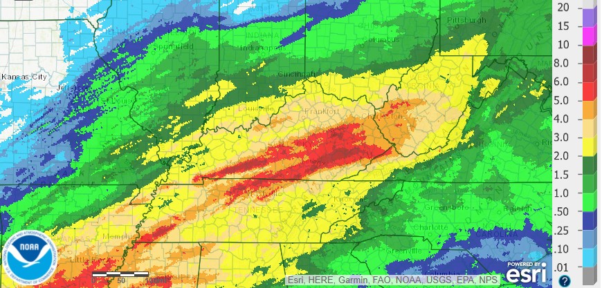
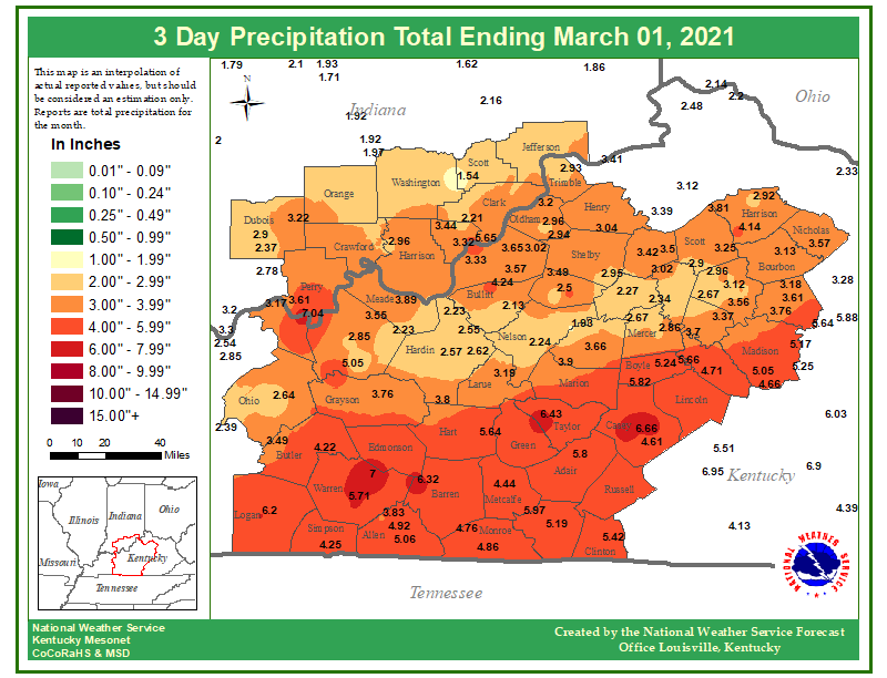 3-Day Observed Rainfall Ending March 1, 2021 |
 |
 |
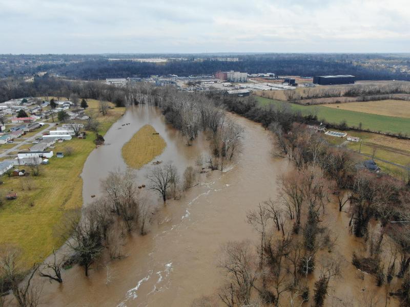 |
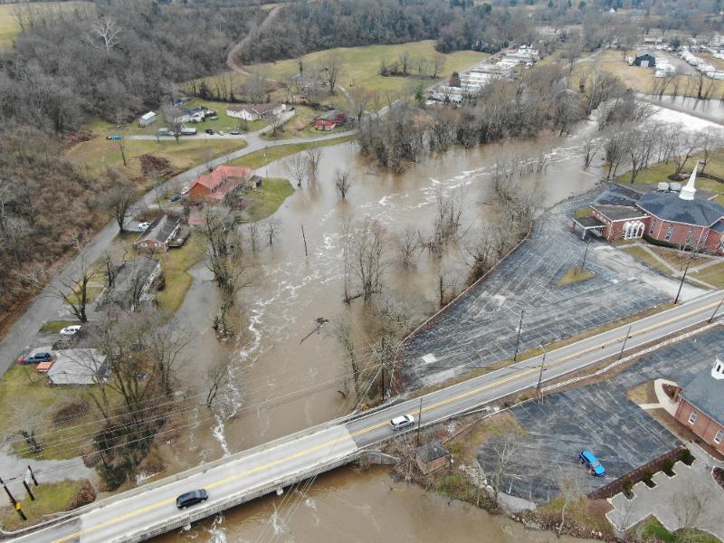
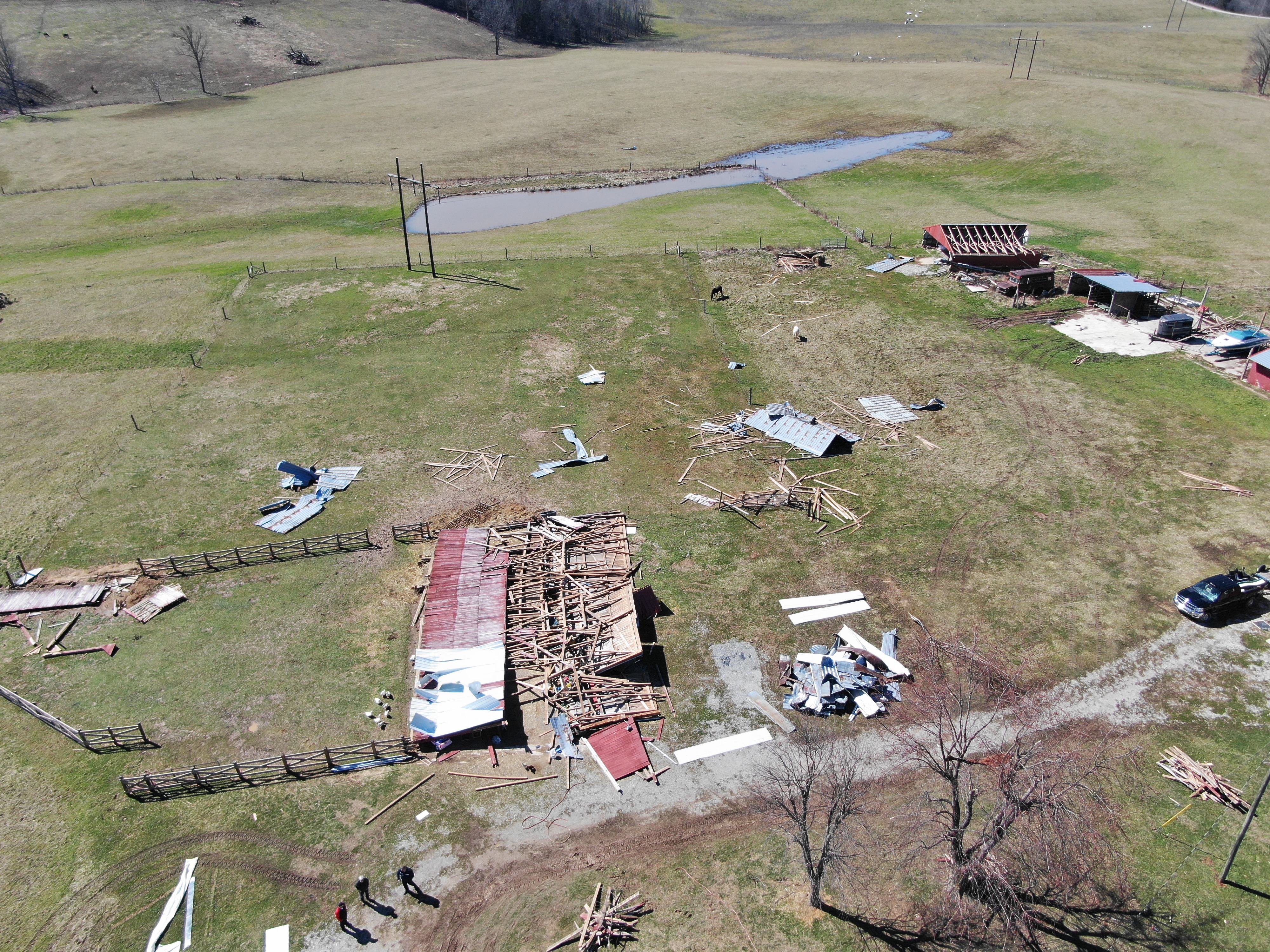
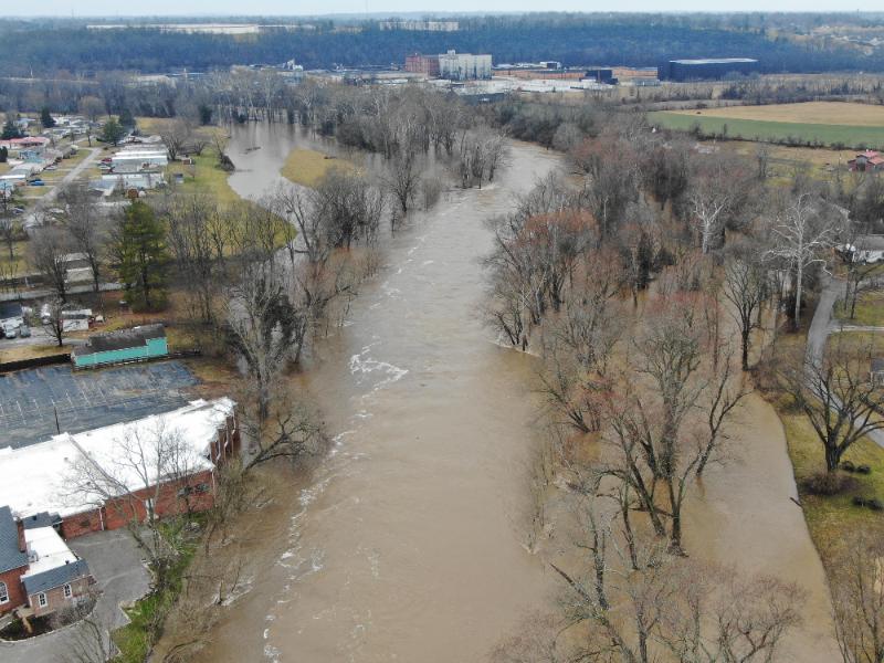
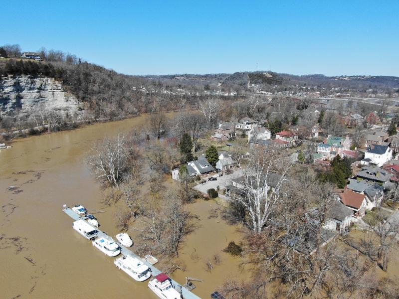
| Franklin County, KY Flooding | EF-1 Tornado Damage in Clinton County, KY | Franklin County, KY Flooding |
Tornadoes
|
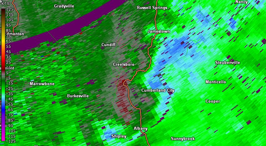
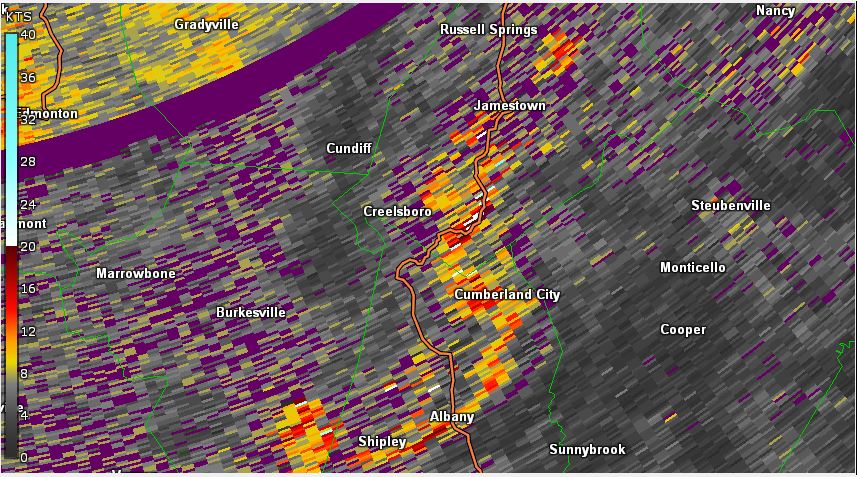
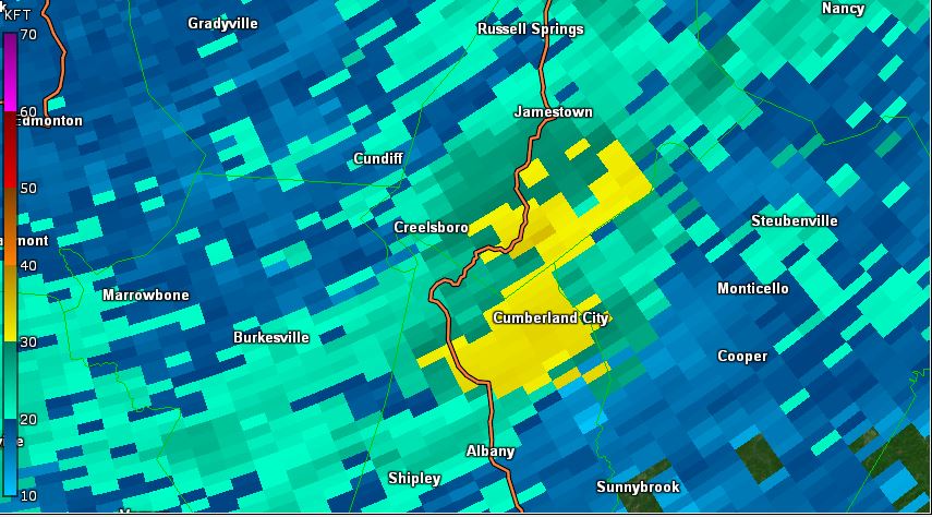
Tornado - CUMBERLAND CITY
Track Map 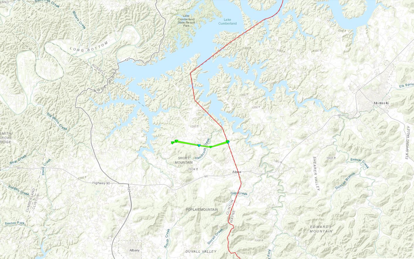 
Downloadable KMZ File |
||||||||||||||||
|
||||||||||||||||
The Enhanced Fujita (EF) Scale classifies tornadoes into the following categories:
| EF0 Weak 65-85 mph |
EF1 Moderate 86-110 mph |
EF2 Significant 111-135 mph |
EF3 Severe 136-165 mph |
EF4 Extreme 166-200 mph |
EF5 Catastrophic 200+ mph |
 |
|||||
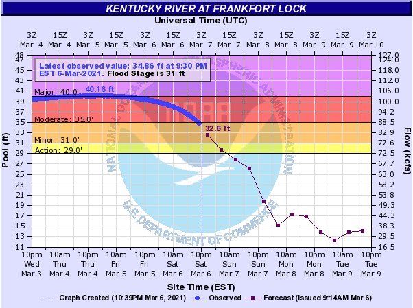
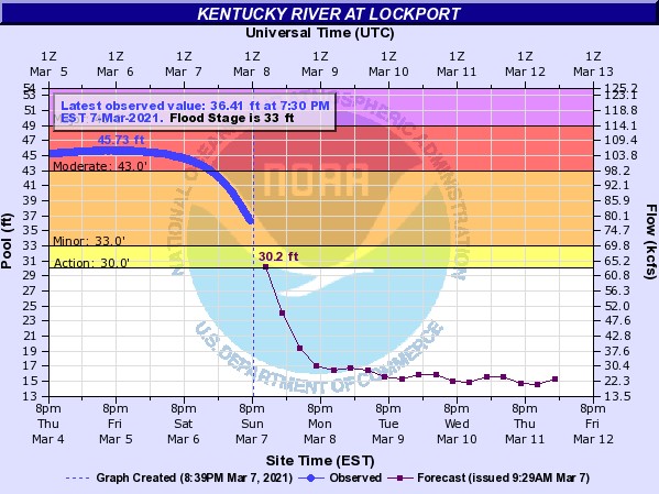
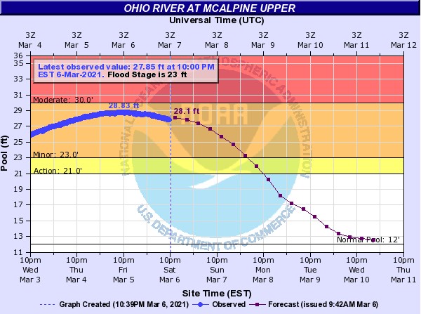
Flooding
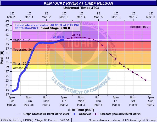
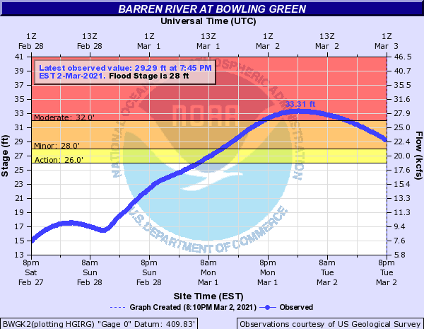
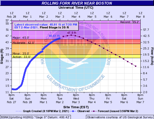
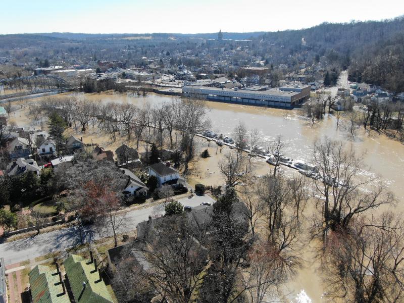
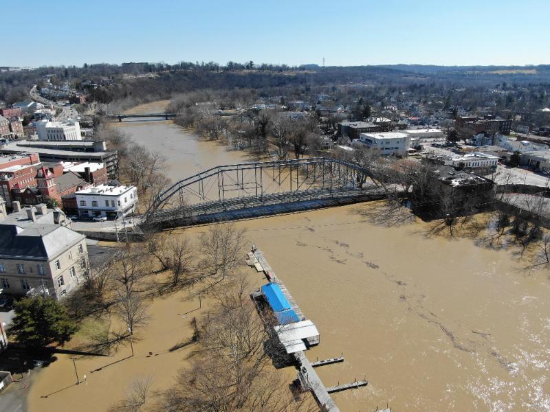
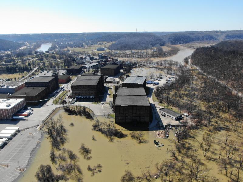
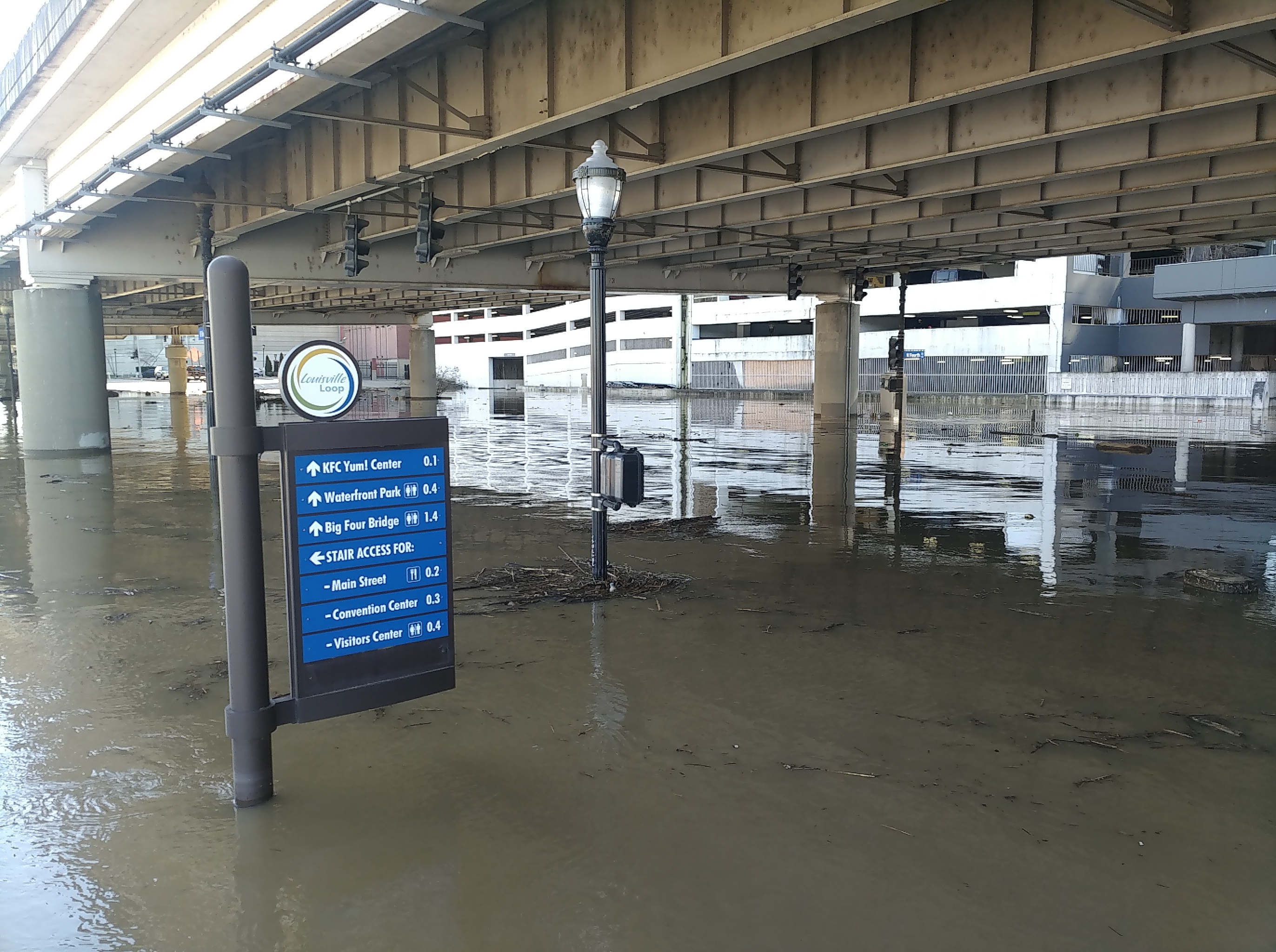
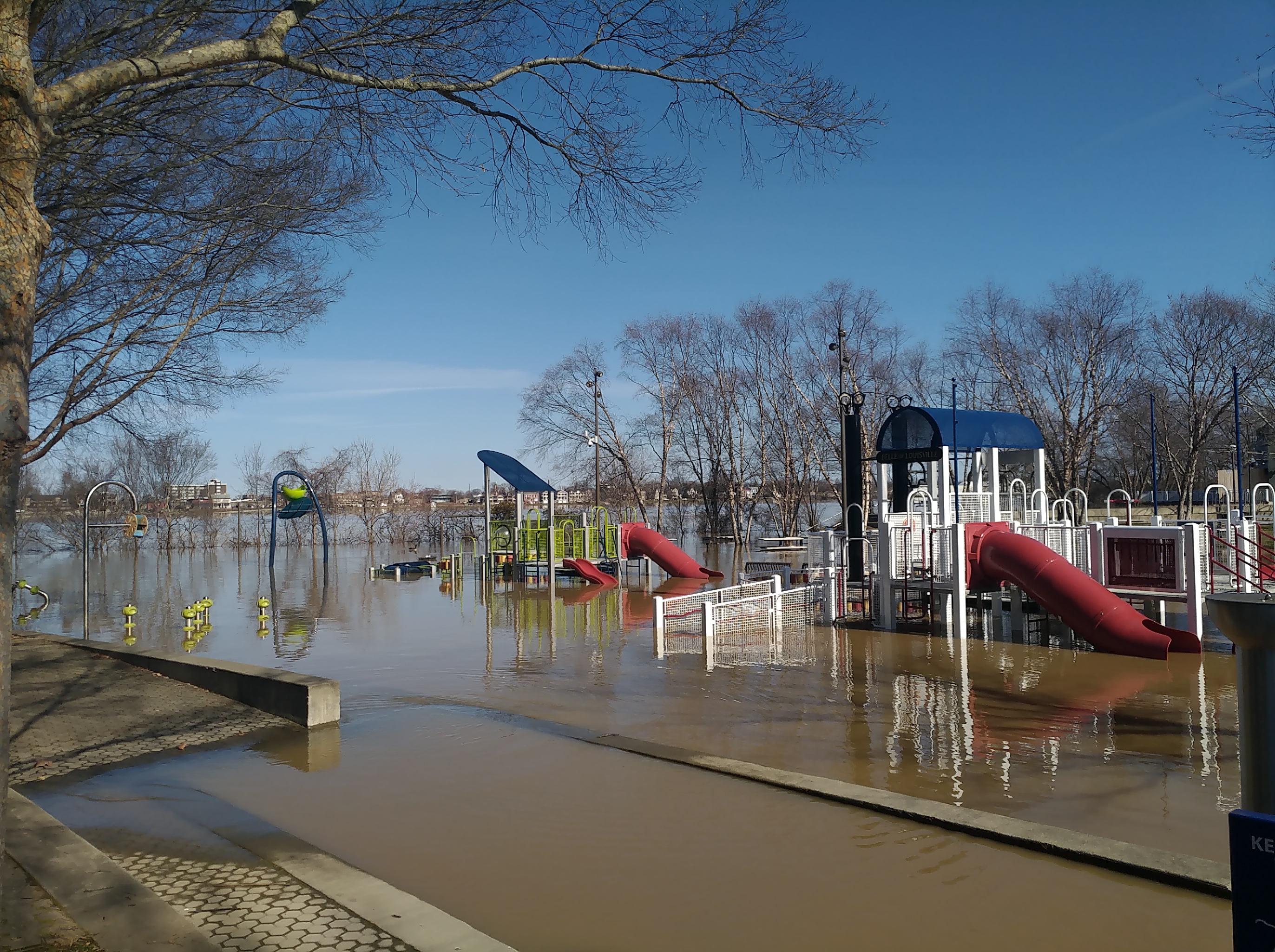
Peak rainfall totals for the whole event ranged from 2-7 inches, with the highest values in south central Kentucky. Heavy rain resulted in widespread flooding, including some flash flooding. Widespread river flooding also occurred, including moderate to major flooding along the Kentucky River.
Hydrographs
 |
 |
 |
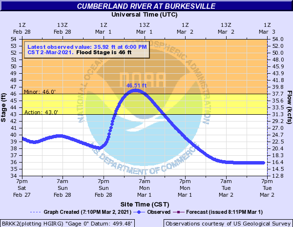 |
| Kentucky River @ Camp Nelson | Barren River @ Bowling Green | Rolling Fork River near Boston | First Flood Warning at new Burkesville point on Cumberland River |
 |
 |
 |
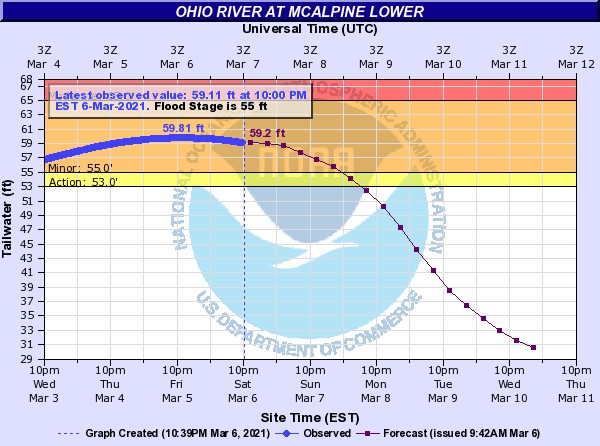 |
| Kentucky River @ Frankfort | Kentucky River @ Lockport | Ohio River @ Louisville (McAlpine Upper) | Ohio River @ Louisville (McAlpine Lower) |
Photos
 |
|
|
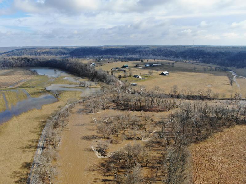 |
| Franklin County, KY Flooding | Franklin County, KY Flooding | Franklin County, KY Flooding | Franklin County, KY Flooding |
 |
 |
 |
 |
| Franklin County, KY Flooding | Franklin County, KY Flooding | Franklin County, KY Flooding | Franklin County, KY Flooding |
Drone footage of the Ohio River at Louisville
Drone footage of the Kentucky River at High Bridge
Drone footage of the Kentucky River in Frankfort
WeatherNation interviews NWS Louisville Meteorologist-in-Charge John Gordon about flooding
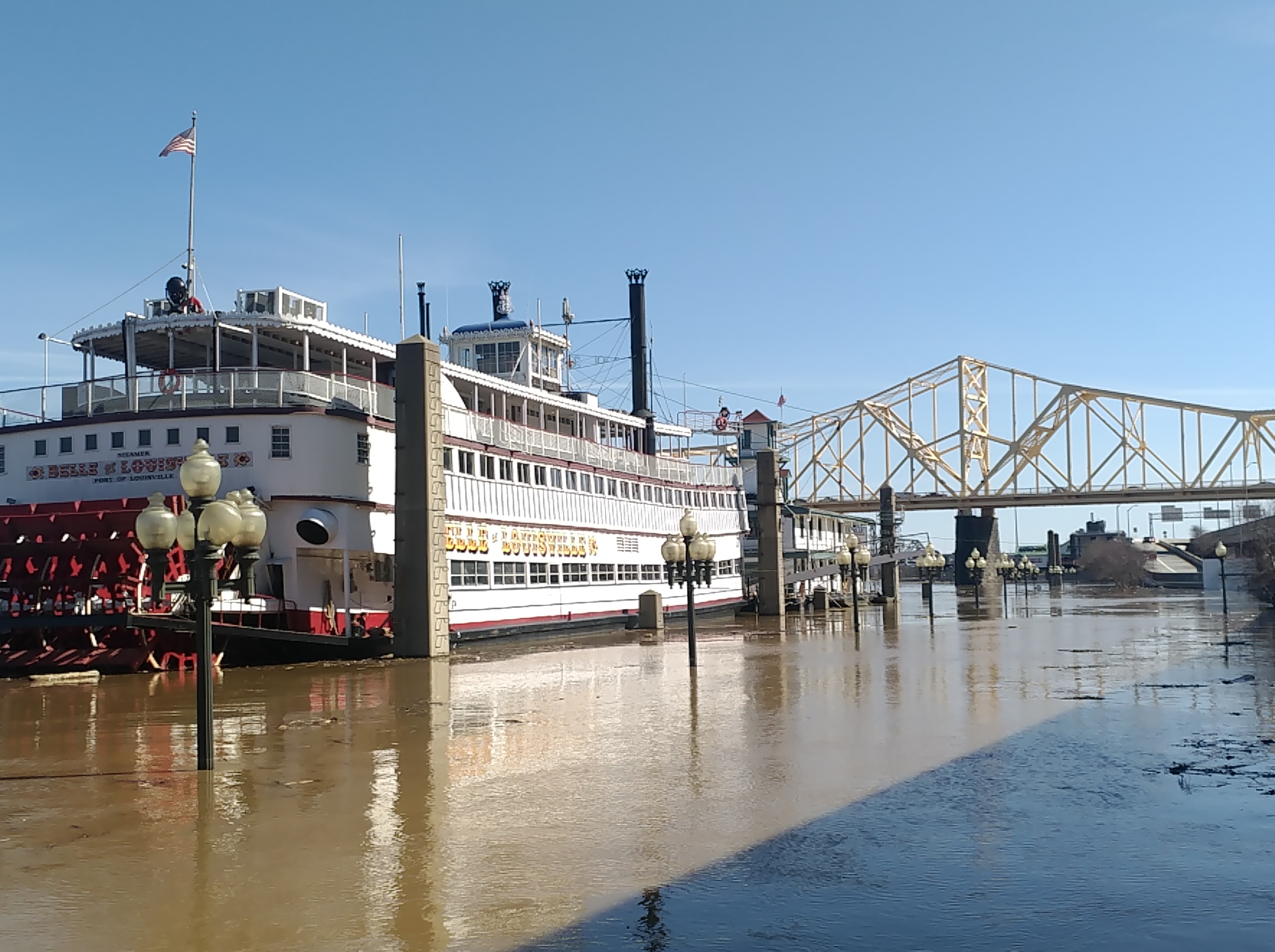
Photos & Video
Flooding
 |
 |
 |
| Belle of Louisville |
Louisville Loop |
Playground in Louisville |
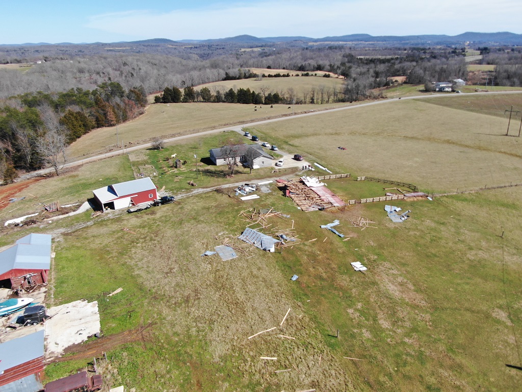
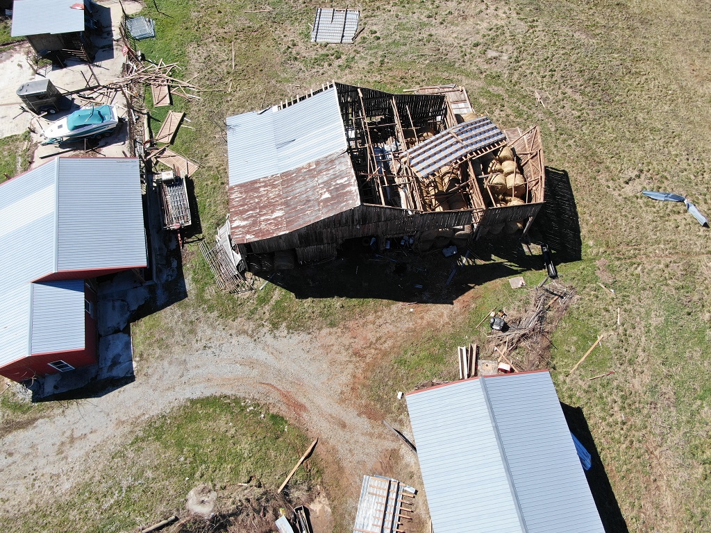
Tornado Damage in Clinton County
 |
 |
 |
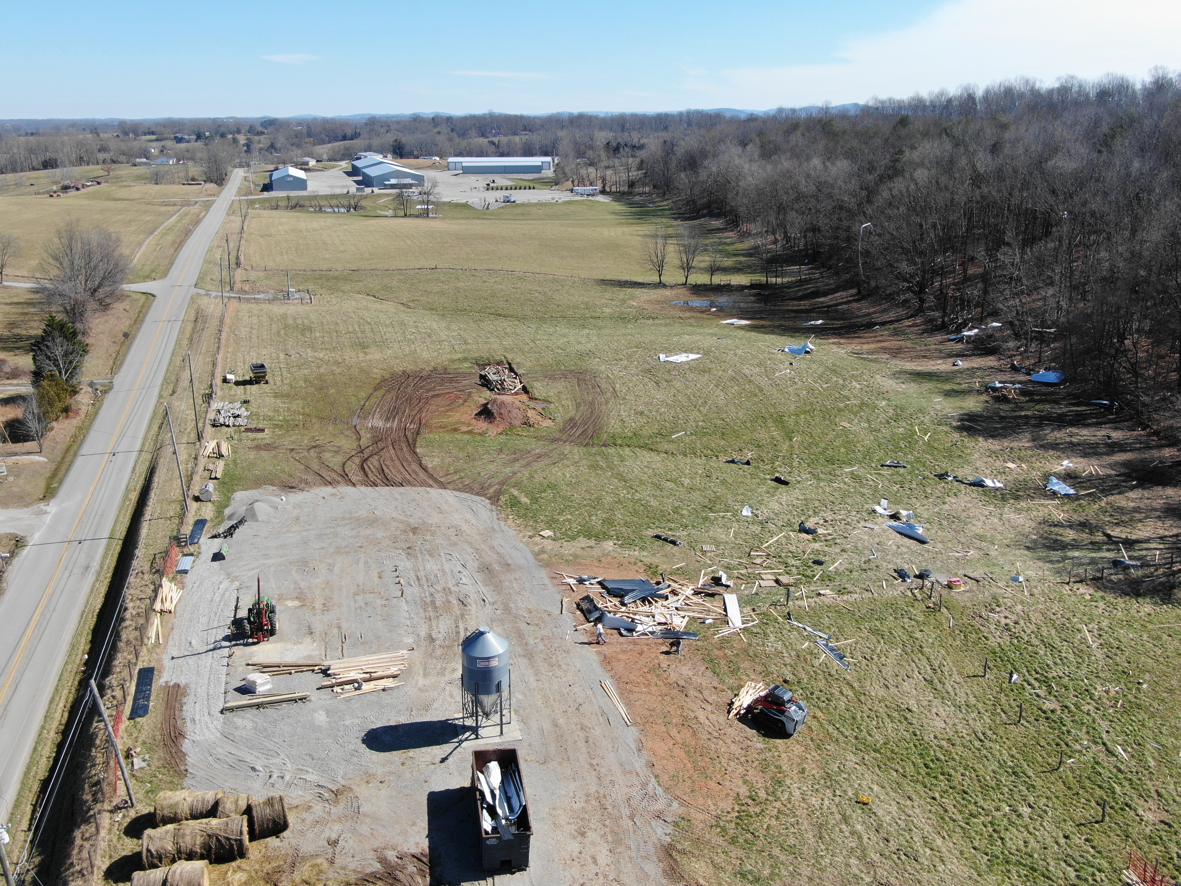 |
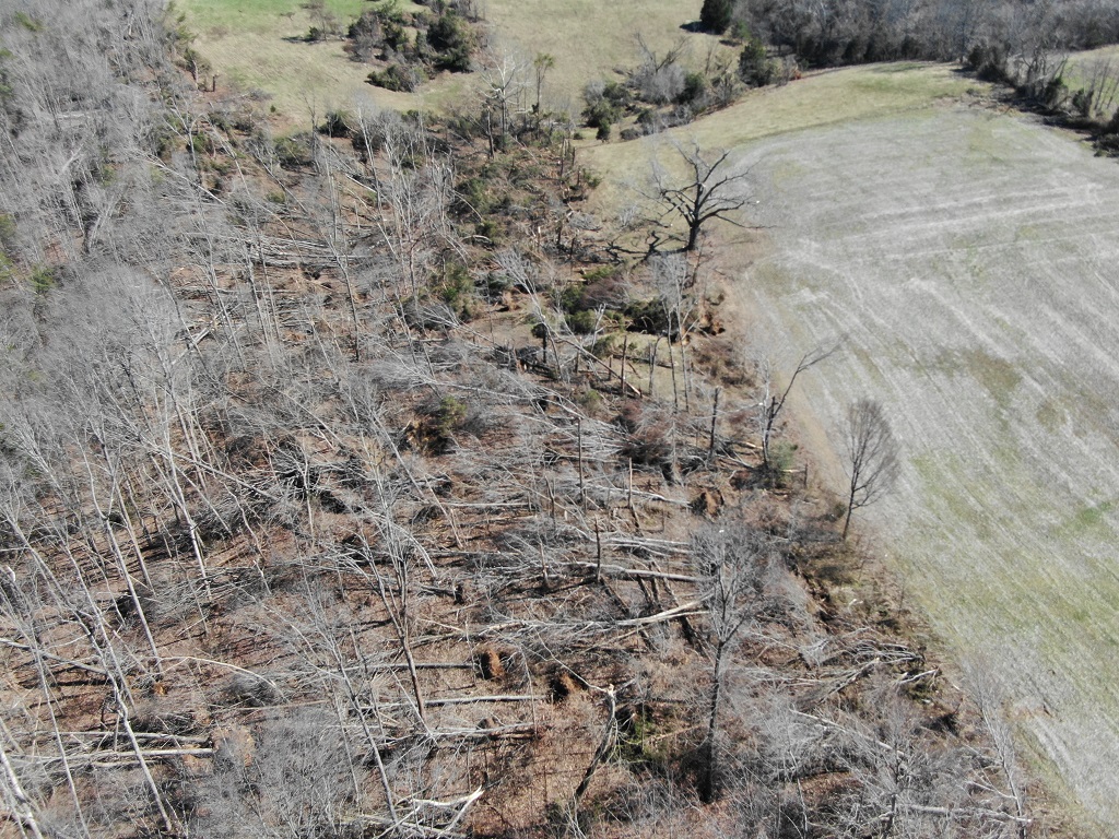
| Drone photo showing rotation patterns in tree damage as well as grass (NWS Storm Survey) |
Additional drone footage (NWS Storm Survey) |
Additional drone footage (NWS Storm Survey) |
Additional drone footage (NWS Storm Survey) |
Storm Reports
..TIME... ...EVENT... ...CITY LOCATION... ...LAT.LON...
..DATE... ....MAG.... ..COUNTY LOCATION..ST.. ...SOURCE....
..REMARKS..
0844 PM Tstm Wnd Dmg 1 N Tompkinsville 36.71N 85.69W
02/28/2021 Monroe KY Law Enforcement
one tree down.
0852 PM Tstm Wnd Dmg 2 ENE Marrowbone 36.82N 85.46W
02/28/2021 Cumberland KY Dept of Highways
HWY 90 W had a road closure due to a downed
utility pole.
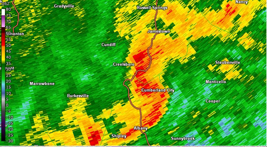
0918 PM Tornado 1 WSW Cumberland City 36.79N 85.09W
02/28/2021 Clinton KY NWS Storm Survey
EF1 tornado on the ground for 4 minutes,
continuing into far western portions of
Wayne county. It caused several uprooted and
or snapped trees and structural damage to
several homes and large barns.
Rain Reports
..TIME... ...EVENT... ...CITY LOCATION... ...LAT.LON...
..DATE... ....MAG.... ..COUNTY LOCATION..ST.. ...SOURCE....
..REMARKS..
0820 PM Heavy Rain 3 SW Liberty 37.28N 84.96W
03/02/2021 M6.65 inch Casey KY Mesonet
Mesonet station PCWN Liberty 3 SW.
0700 PM Heavy Rain 4 N Albany 36.75N 85.13W
03/02/2021 M6.63 inch Clinton KY Mesonet
Mesonet station ALBK2 Albany 4 N.
0812 PM Heavy Rain 5 ESE Rhoda 37.13N 86.15W
03/02/2021 M6.57 inch Edmonson KY Mesonet
Mesonet station CDSK2 Houchin Meadow.
0200 PM Heavy Rain 3 ESE Mammoth Cave 37.19N 86.04W
03/02/2021 M6.43 inch Hart KY CO-OP Observer
CO-OP Observer station MAMK2 3.4 E Mammoth
Cave.
0820 PM Heavy Rain 4 N Black Gnat 37.36N 85.46W
03/02/2021 M6.40 inch Taylor KY Mesonet
Mesonet station BNGL Campbellsville 7 W.
0820 PM Heavy Rain 2 SE Hays 37.01N 86.11W
03/02/2021 M6.29 inch Barren KY Mesonet
Mesonet station MROK Glasgow 11 W.
0820 PM Heavy Rain 2 NW Russellville 36.85N 86.92W
03/02/2021 M6.19 inch Logan KY Mesonet
Mesonet station RSVL Russellville 2 W.
0900 AM Heavy Rain 1 N Dubre 36.85N 85.55W
03/02/2021 M5.87 inch Cumberland KY Cocorahs
Cocorahs station KY-CM-1 Dubre 1.0 NE.
0820 PM Heavy Rain 3 SSE Cane Valley 37.14N 85.29W
03/02/2021 M5.75 inch Adair KY Mesonet
Mesonet station CMBA Columbia 3 N.
0815 PM Heavy Rain 3 NE Rich Pond 36.93N 86.47W
03/02/2021 M5.67 inch Warren KY Mesonet
Mesonet station FARM Bowling Green 5 S.
0820 PM Heavy Rain 1 ENE Hardyville 37.26N 85.78W
03/02/2021 M5.60 inch Hart KY Mesonet
Mesonet station HDYV Munfordville 6 E.
0753 PM Heavy Rain 1 ESE Bowling Green 36.97N 86.42W
03/02/2021 M5.54 inch Warren KY ASOS
ASOS station KBWG Bowling Gree.
0815 PM Heavy Rain 1 N Albany 36.71N 85.14W
03/02/2021 M5.39 inch Clinton KY Mesonet
Mesonet station ALBN Albany 1 N.
0818 PM Heavy Rain 1 WSW Rich Pond 36.89N 86.52W
03/02/2021 M5.35 inch Warren KY Mesonet
Mesonet station CW2972 Bowling Green.
0815 PM Heavy Rain Liberty 37.32N 84.94W
03/02/2021 M5.34 inch Casey KY Mesonet
Mesonet station EW7213 Liberty.
0800 PM Heavy Rain 3 E Sweeden 37.25N 86.23W
03/02/2021 M5.31 inch Edmonson KY Mesonet
Mesonet station BOWK2 MAMMOTH CAVE BOWLING
GREEN 21NNE KY US.
0756 PM Heavy Rain 1 WNW Burkesville 36.80N 85.38W
03/02/2021 M5.22 inch Cumberland KY Mesonet
Mesonet station TR889 Alpine.
0820 PM Heavy Rain 1 SSW Waco 37.72N 84.15W
03/02/2021 M5.16 inch Madison KY Mesonet
Mesonet station ELST Richmond 8 E.
0820 PM Heavy Rain 3 WSW Danville 37.62N 84.82W
03/02/2021 M5.13 inch Boyle KY Mesonet
Mesonet station DANV Danville 3 SW.
0815 PM Heavy Rain 4 W Mintonville 37.19N 84.91W
03/02/2021 M5.11 inch Casey KY Mesonet
Mesonet station EW5790 Liberty.
0820 PM Heavy Rain 4 WNW Burkesville 36.80N 85.43W
03/02/2021 M5.11 inch Cumberland KY Mesonet
Mesonet station GRDR Burkesville 3 W.
0100 PM Heavy Rain 3 E Sweeden 37.25N 86.23W
03/02/2021 M5.03 inch Edmonson KY Mesonet
Mesonet station BOWK2 MAMMOTH CAVE BOWLING
GREEN 21NNE KY US.
0700 PM Heavy Rain 2 WSW Burkesville 36.78N 85.40W
03/02/2021 M4.97 inch Cumberland KY CO-OP Observer
CO-OP Observer station BRKK2 1.8 W
Burkesville.
0900 AM Heavy Rain 3 SE Halfway 36.77N 86.25W
03/02/2021 M4.93 inch Allen KY Cocorahs
Cocorahs station KY-AL-14 Scottsville 3.5
WNW.
0900 AM Heavy Rain 1 NNE Rapids 36.68N 86.46W
03/02/2021 M4.92 inch Simpson KY Cocorahs
Cocorahs station KY-SM-5 Franklin 7.1 ESE.
0819 PM Heavy Rain 2 ENE Roseville 36.90N 85.88W
03/02/2021 M4.62 inch Barren KY Mesonet
Mesonet station CW9659 Glasgow.
0815 PM Heavy Rain 3 NNW Glasgow 37.03N 85.95W
03/02/2021 M4.49 inch Barren KY AWOS
AWOS station KGLW Glasgow.
0820 PM Heavy Rain 1 SSW Wisdom 36.99N 85.70W
03/02/2021 M4.41 inch Metcalfe KY Mesonet
Mesonet station RNDH Edmonton 5 W.
0820 PM Heavy Rain 3 E Providence 36.67N 86.61W
03/02/2021 M4.24 inch Simpson KY Mesonet
Mesonet station SWZR Franklin 4 SW.
0820 PM Heavy Rain 1 SW Woodbury 37.18N 86.65W
03/02/2021 M4.21 inch Butler KY Mesonet
Mesonet station WDBY Morgantown 4 SSE.
0815 PM Heavy Rain 2 SSE Albany 36.66N 85.11W
03/02/2021 M4.10 inch Clinton KY Mesonet
Mesonet station 3863D 2 SE Albany.
0815 PM Heavy Rain Fern Creek 38.16N 85.61W
03/02/2021 M4.06 inch Jefferson KY Mesonet
Mesonet station EW9362 Louisville.
.
Environment
Synoptic Environment
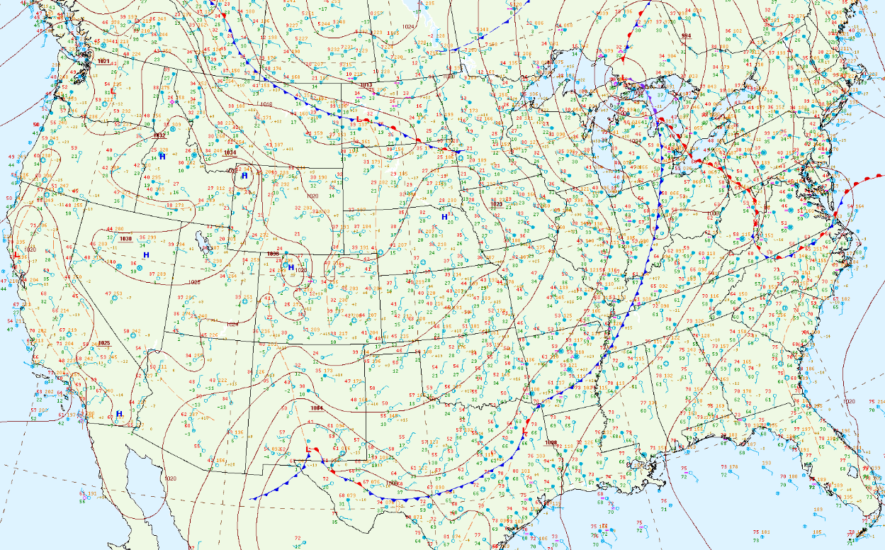 |
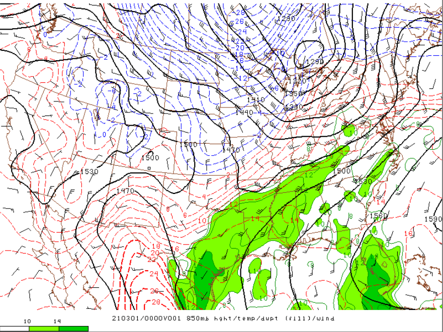 |
 |
.png) |
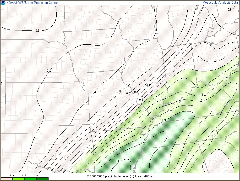
| Figure 1: February 28, 7 PM EDT Surface Analysis | Figure 2: 850mb March 1, 00Z | Figure 3: Precipitable Water March 1, 00Z | Figure 4: 300mb March 1, 00Z |
Near-storm Environment
 |
 |
 |
|
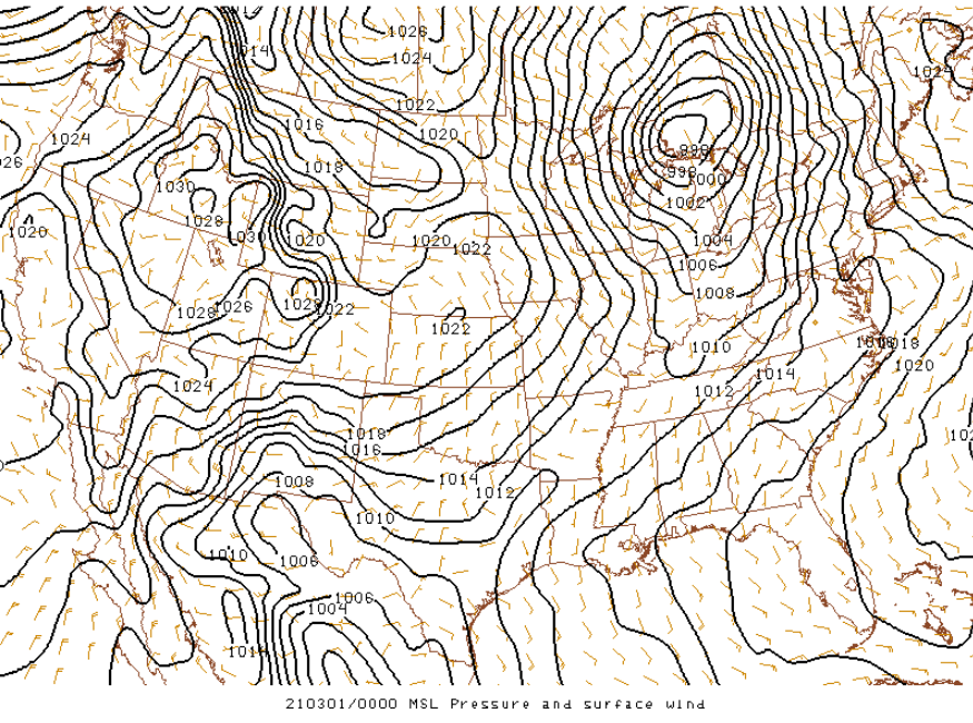
Figure 5: February 28, 7 PM EDT MSL Pressure |
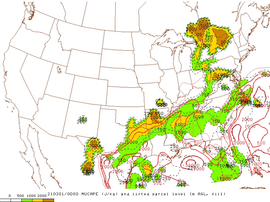
Figure 6: February 28, 7 PM EDT MUCAPE |
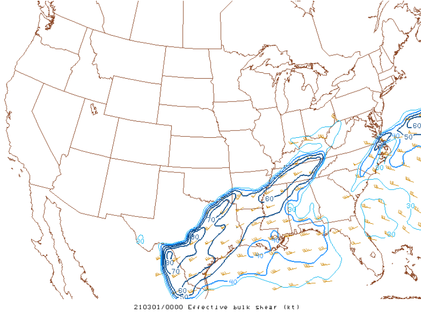
Figure 7: February 28, 7 PM EDT Effective Bulk Shear |
Additional environmental data
 |
 |
 |
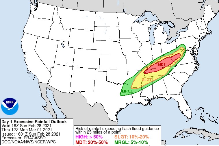
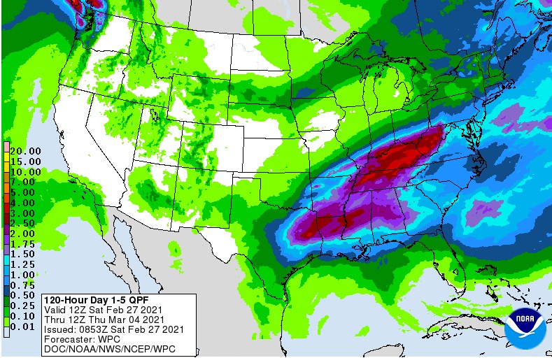
| Day One Excessive Rainfall Outlook from the Weather Prediction Center (WPC) | WPC Storm Total Precipitation Forecast from the morning of February 27 | Total Rainfall |
 |
Media use of NWS Web News Stories is encouraged! Please acknowledge the NWS as the source of any news information accessed from this site. |
|


 Weather Story
 Weather Map
 Local Radar